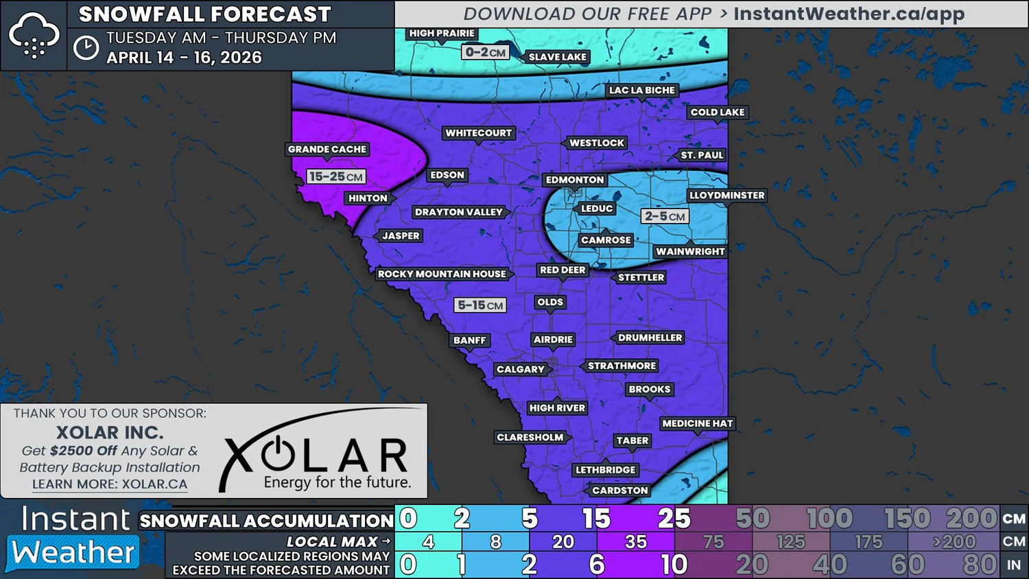
A One-Two Punch of Winter Weather Could Bring Up to 15cm of Snow to Much of Central & Southern Alberta This Week
/
NOTE: YOU CAN CLICK ON THE MAP TO OPEN A ZOOMABLE IMAGE
As is to be expected for April in Alberta, winter’s grip isn’t quite ready to let go, despite some mild, spring-like conditions having already made brief appearances.
This week, two separate systems will bring fresh snow across Central and Southern Alberta, and into parts of Northern Alberta. Even though these two systems will originate from different places, the tail end of the first system will meld into the leading edge of the second. As a result, we have opted to create a single forecast for both storms.
The snow will begin to fall early Tuesday morning in Jasper National Park and into the Grande Cache area, where it will fairly light and scattered for most of the day. Some pockets snow could stretch east towards Edson and Drayton Valley during the morning, but it is expected to be mixed with rain, which will limit any accumulating snow.
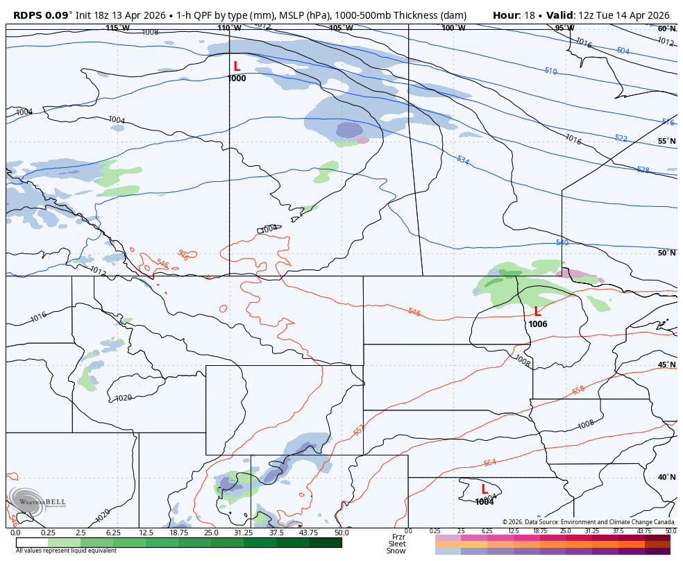
The rdps model showing precipitation type and intensity at 6Am MT on Tuesday, courtesy of WeatherBell.
During the evening is when we expect to really start to see precipitation pushing eastward across the province. As with the possibility of this in the morning, the precipitation will fall as rain initially, since it will be above freezing, but it will change over to snow overnight as the temperatures fall.
This won’t be a very wide band of precipitation, impacting the southern extent of Northern Alberta as far north as Slave Lake. A shift in the track since Sunday afternoon means that the bulk of this snow is now expected to stay north of Edmonton. The band of snow will settle over this region overnight and through to Wednesday afternoon.
The steady light to moderate snowfall during this period will result in 5-15cm of accumulation across much of the impacted region, with up to 25cm possible in the Grande Cache area as a result of the prolonged snow beginning on Tuesday.
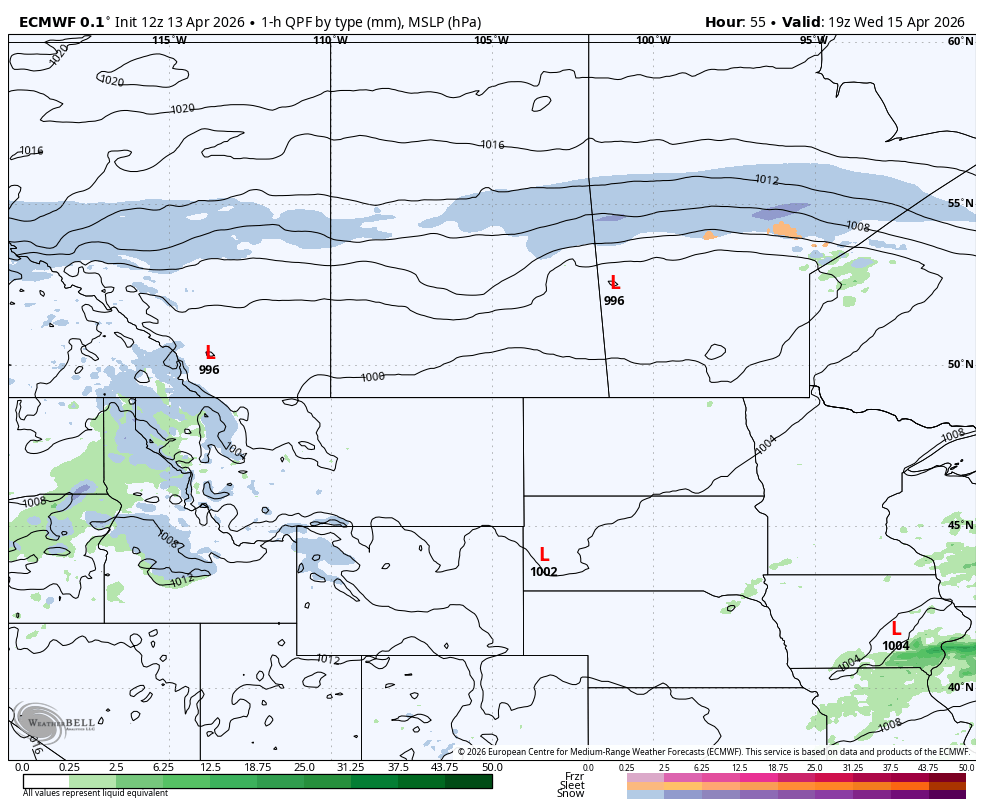
The ECMWF model showing precipitation type and intensity at 1pm MT on Wednesday, courtesy of WeatherBell.
In the late afternoon, snow from the second system will start to make its way into the Southern Rockies from the southwest. Meanwhile the band of snow to the north will begin to sink southward. These two areas of snow will combine, leading to one large area of snowfall developing over most of Central and Southern Alberta in the late evening.
This large region of snowfall will maintain its position over the region into Thursday morning. Then in the afternoon, the snow will start to gradually taper off as the entire system continues to track eastward across the Prairies. The snow is expected to completely exit the province by midnight.
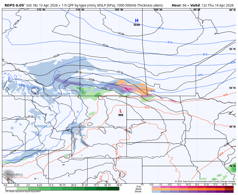
The rdps model showing precipitation type and intensity at 6Am MT on Thursday, courtesy of WeatherBell.
The combination of these two systems, which will impact different parts of the province, means that snow will end up accumulating over a considerable portion of Alberta.
As previously mentioned, the first system is expected to bring 5-15cm to parts of Northern Alberta, while the Grande Cache area may see up to 25cm. The amount of snow that falls in this part of the province will be very dependent on when the transition from rain to snow occurs Tuesday night; a delayed shift would limit how much snow ends up falling.
As far as the remnants of the first system merging with the second are concerned, the steady rate of snowfall will also lead to 5-15cm of snow falling over the majority of Central and Southern Alberta. There are a couple of exceptions, though.
It’s looking likely that before the band of snow impacting Northern Alberta starts to track southward Wednesday evening, the snow might taper off slightly in the east. This would reduce the amount of snow that accumulates in a stretch from Edmonton to Lloydminster.
There is also possibility that there could be some rain falling instead of snow in the Southeast corner of the province during the early morning hours of Thursday, which would also greatly reduce the amount of accumulating snow. However, there is still some disagreement between weather models on whether this occurs. Nonetheless, these two possibilities are reflected on our forecast map as areas that could receive less than 5cm.
It’s also worth noting that the snow could be heavy at times in eastern parts of Central and Southern Alberta as the second system hits the region. Some weather models are showing that this could lead to some areas receiving over 15cm of snow. While this is a possibility on a local scale, the snow in this region is expected to melt on contact with the warm ground at first, before it eventually starts to stick. This should therefore keep accumulations below the 15cm mark.
Since the arrival of the second system is still 48 hours away from when this forecast is originally being posted (on Monday evening), it is possible that we could see some changes in its track and the amount of snow it could bring. We will continue to monitor the situation and have an updated forecast if there are any significant changes.


