Soaking Rains Will Mark the End of May and Start of June Across Most of Alberta, More Than 100mm Possible Over Four Days
/
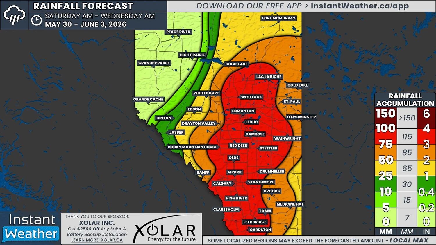
NOTE: YOU CAN CLICK ON THE MAP TO OPEN A ZOOMABLE IMAGE
It’s been a scorcher of a week for parts of Alberta and it’s felt more like summer thanks to temperatures climbing into the low-to-mid 30s, which is 10-20°C above seasonal, depending on the location. Now, the upper level ridge responsible for the heat is shifting eastward and it will be replaced by more moderate temperatures across the province.
Alongside these cooler temperatures, we are also looking at several days of much-needed rain that is expected to fall over the majority of Alberta. Unfortunately, it’s looking like the heavy rain won’t make it into Northwestern Alberta so those in this region will have to make do with what falls on Friday and into early Saturday.
Patchy areas of light and moderate rainfall will start to make its way into Southern Alberta from the States on Saturday morning from a low pressure system over Montana. The low will gradually track north towards the Saskatchewan border through the day and with it, the rain will also spread northwards. Rain will also cross from Saskatchewan into later in the day to create one large area of rainfall that covers much of the eastern half of the province by Sunday morning.
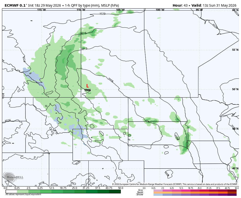
The ECMWF model showing precipitation type and intensity at 7AM MT on Sunday, courtesy of WeatherBell.
The low pressure center should be located over Southwestern Saskatchewan before sunrise on Sunday. This is when the low is expected to strengthen, which will lead to heavier rain falling across Eastern Alberta. The system will slowly continue tracking north throughout Sunday, which will bring the rain up to the Northwest Territories border by the evening.
On Saturday alone, at least 10mm of rain is expected fall across the eastern half of the province and conservatively, up to 50mm could be possible in parts of East Central and Northeastern Alberta.
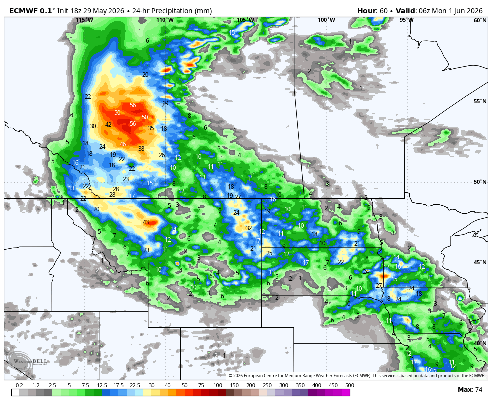
The ECMWF model showing total precipitation over 24 hours up to 12am MT Monday, courtesy of WeatherBell.
The rain will continue to fall into Monday, with the continuation of heavy rain as well. However, the system will begin to fall apart in the afternoon and the rain will end for most of Northeastern Alberta.
The rain will continue to fall in East Central and Southern Alberta throughout the day, but there could be breaks in the rainfall, as well as periods of heavy rain. These opposite ends of the spectrum make the rainfall totals on Monday a bit tougher to forecast.
Once again, at least 10mm of rain is expected to fall over a significant area over the course of Monday. Overall, not as much rain is expected to fall on Monday than on Sunday, but some areas could still see up to 40mm of rain by the end of the day.
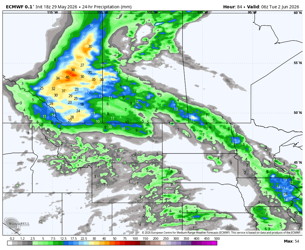
The ECMWF model showing total precipitation over 24 hours up to 12am MT Tuesday, courtesy of WeatherBell.
Going into Tuesday, there is still expected to be some pockets of heavier rain that will continue during the morning. However, the remaining rain will gradually taper off through the day, ending by Wednesday morning.
By the time the rain comes to an end Wednesday morning, more than 50mm of rain is expected to have fallen over a large portion of Alberta. Along the Highway 2 corridor and extending north of Edmonton, 75-100mm of rain is expected to fall and potentially over 100mm locally. The heaviest rain will fall at an average of 3-5mm/hr, but there could possibly be pockets of intense rain falling at 10-15mm/hr, which could really drive these totals up.
Seeing as this is an event that will occur multiple days, it’s possible that there could be a shift in where the rain ends up falling between the time that this forecast is posted (Friday evening) and Monday, in particular. We will be watching how the system sets up and if there are any major changes, we’ll be sure to keep you updated! Nonetheless, this is expected to make a huge impact to the fire danger across much of Alberta.