Rare November Stratospheric Warming Event Could Spread Arctic Chill Across Canada for December
/
You may have heard a new term being thrown around in the news and on social media: “Sudden Stratospheric Warming”. It’s not a new term, meteorologically speaking, and it’s related to the polar vortex. It happens most winters, but it’s making headlines now because of how early it is happening; it has only occurred three times in the month of November over the last 70 years. Additionally, this could be the earliest instance of sudden stratospheric warming on record and it could lead to some very cold temperatures across the country in the coming weeks.
It’s certainly nothing we can’t handle, but it’s always interesting to learn about how something happening in the Arctic, 10s of kilometres above the surface, can impact our day-to-day weather.
Before we dive into what sudden stratospheric warming is, however, we’re going to need a bit of background information. The first thing we need to know is what and where the stratosphere is.
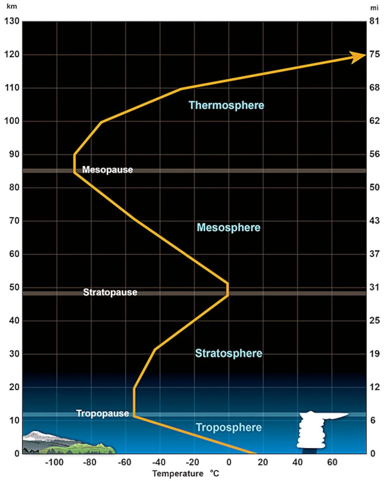
The layers of the atmosphere. Image courtesy of NOAA.
The Earth’s atmosphere is made up of layers and the stratosphere is the second layer from the surface, stretching from 10-50km above the surface. It sits on top of the troposphere, which is where we live and all our weather occurs. The two layers are separated by the tropopause, where the temperature stops decreasing with height and it instead stabilizes. Moving higher, into the stratosphere, the temperature increases with height and the layer itself is quite stable, making it ideal for commercial planes to fly in.
Next, we need a bit of understanding of the polar vortex. This is a concept that has become more mainstream in the last 10 years or so, but there’s a bit more to it than just a period of cold weather.
The easiest way to explain the polar vortex is to imagine a spinning wall of wind, called the polar night jet, in the stratosphere that traps cold air over the Arctic. The polar vortex is always there, but it is weaker in the summer and stronger in the winter during polar night, which is how the polar night jet gets its name.
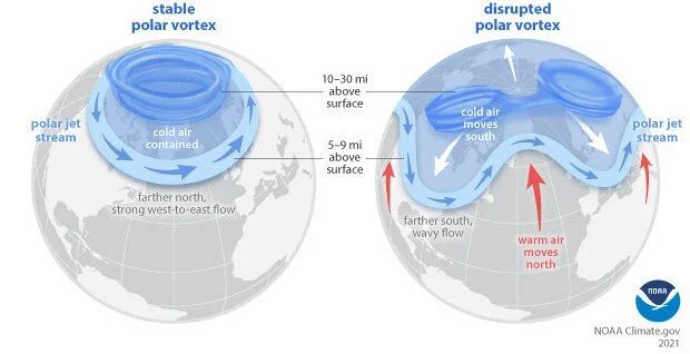
A stable polar vortex vs a disrupted polar vortex. Image courtesy of NOAA.
When the polar vortex is stable, it can be almost perfectly circular and centred over the North Pole, while the polar jet stream in the troposphere stays further north and flows west to east. However, the polar vortex can be disrupted and the circulation weakened, allowing cold air to flood southwards and pushing the polar jet stream further south and making it become wavy.
One of the main ways the polar vortex can be disrupted is through a sudden stratospheric warming event. As the name suggests, sudden stratospheric warming is when we see sudden warming in the stratosphere, particularly over the polar regions. This could be upwards of 40°C of warming over the course of only a few days!
Sudden stratospheric warming is typically caused by strong upper level high pressure that interacts with the low pressure polar vortex. The high pressure pushes the polar vortex away from the North Pole, settles there in its place and blocks out the polar vortex. Air always falls within a high so once the high pressure replaces the polar vortex, the air in the stratosphere collapses, warming as it falls due to compressional heating and resulting in the sudden stratospheric warming.
Meanwhile, the polar vortex has become weakened and disrupted, forcing the polar jet stream to become wavy and the polar night jet slows down or even reverses direction. This all results in cold air flooding the mid-latitudes throughout the Northern Hemisphere until the blocking high weakens and the polar vortex can restrengthen, allowing it to move back to over the North Pole.

The modelled presence of a high over the north pole (shown in Yellow, red and Pink)and the polar vortex at lower lower latitudes (shown in blue, purple in green) on November 23rd. image courtesy of WeatherBell.
Weather models are showing that we could see the beginnings of a sudden stratospheric warming event starting in the coming days and temperatures in the stratosphere could jump to 30°c above normal. This means that there could be an outbreak of cold Arctic air in the next two weeks or so.
How long this cold air outbreak lasts is dependent on the strength of the sudden stratospheric warming event. If the incoming high pressure is disruptive enough for the winds of the polar night jet to reverse, the Arctic air could persist over the country for several weeks. Two of the previous three instances of sudden stratospheric warming in November saw this wind reversal and in those years, the cold lasted throughout the month of December.
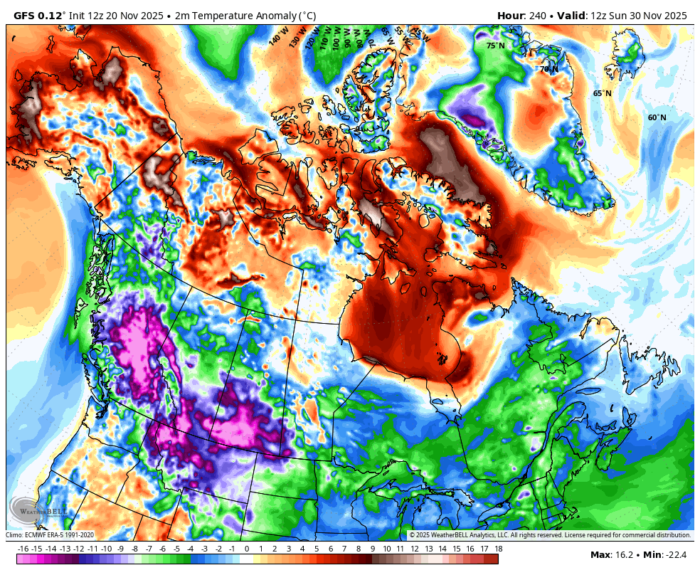
The GFS Model of temperature anomalies (departures from normal) on the morning of November 30th. Image courtesy of WeatherBell.
It’s important to note that there is still some uncertainty in how all of the pieces will come together for this possible sudden stratospheric warming event and there’s a slight possibility that it doesn’t even happen. However, it’s becoming increasingly likely that we will see a disruption in the polar vortex so it becomes a question of who gets the cold, how cold it gets, and for how long.
The American GFS model, for instance, shows the Arctic air arriving in British Columbia and Alberta by mid-next week and spreading eastward in the following days. By Sunday morning, much of the country could see temperatures well below seasonal and some areas could see temperatures of 20°C below normal.
As we get closer to the sudden stratospheric warming taking place, we will have a clearer look at how long the Arctic air could be around. Until then, now might be a good time to dig out all your winter gear because you might need it!


