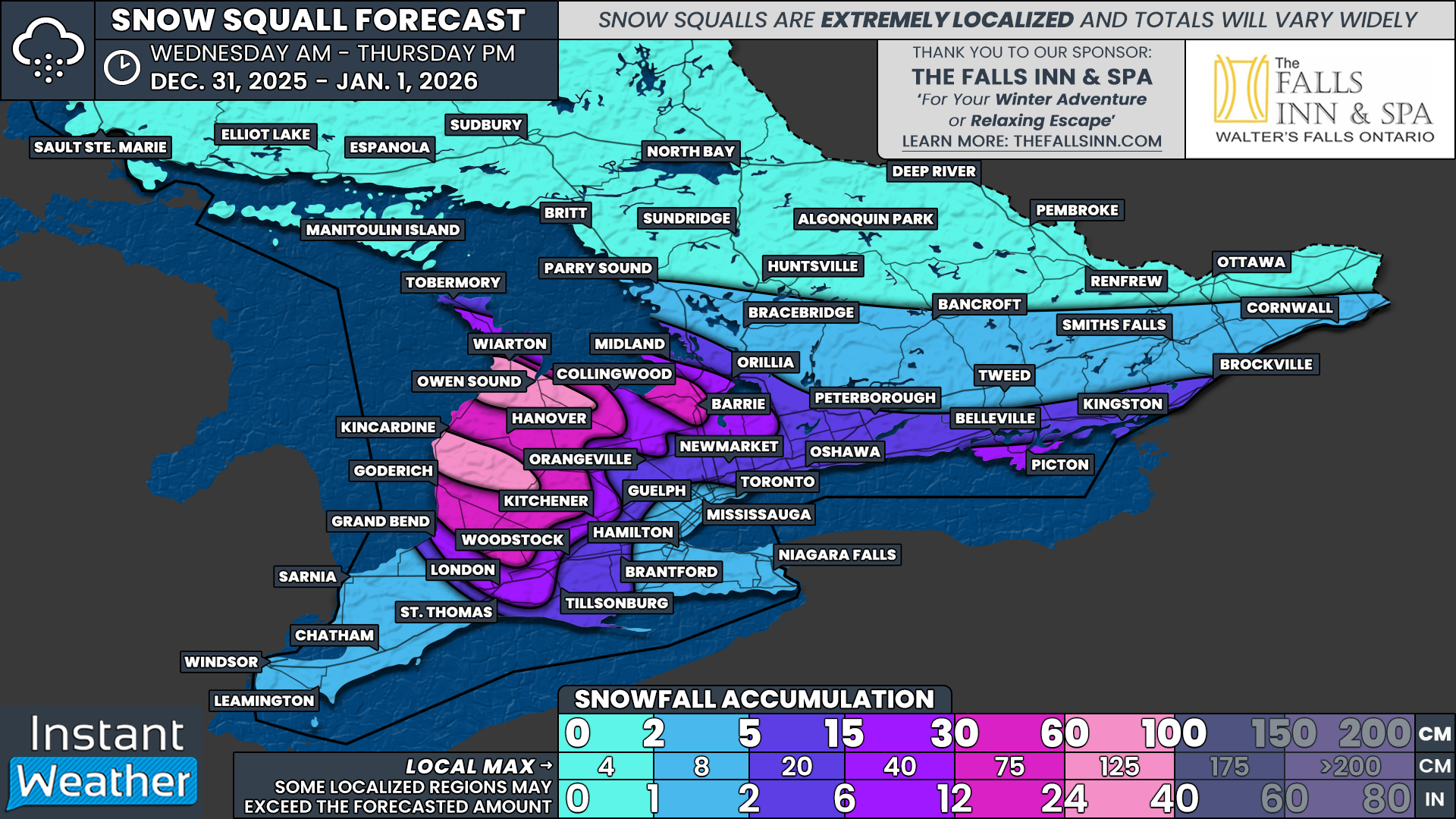
Parts of Southern Ontario To Ring In the New Year Buried in Up to 100cm of Additional Snow by Thursday
/
NOTE: YOU CAN CLICK ON THE MAP TO OPEN A ZOOMABLE IMAGE
The weather story this week has been dominated by intense snow squalls that have practically paralyzed areas east of Lake Huron and southeast of Georgian Bay, and this prolonged event is far from finished.
As of Tuesday evening, many roads across Huron, Perth, Grey, Bruce and Simcoe Counties have been closed due to dangerous whiteout conditions and rapidly accumulating snow. Springwater Township has even issued an emergency alert asking residents to stay off the roads entirely, citing the inability for emergency services to safely respond.
Unfortunately, the situation is expected to continue into the New Year as snow squall activity remains locked in across the region. Additional road closures are possible as squalls continue to drift and redevelop through Grey and Bruce Counties on Wednesday. Blowing snow will remain a major concern, even during brief lulls in snowfall, keeping travel extremely hazardous.
With snow squalls persisting and slowly shifting over the next 48 hours, widespread snowfall totals east of Lake Huron are expected to range from 30 to 60cm by the end of Thursday. We continue to highlight a few high-impact pockets between Owen Sound and Goderich, including areas near Chatsworth, Wingham and Point Clark, where total snowfall could approach or even reach 100cm if the most intense bands remain locked in place.
Simcoe County will also continue to be affected on and off through Wednesday and Thursday. A narrow but intense zone that includes hard-hit Springwater Township, along with Wasaga Beach, Barrie and Angus, could pick up an additional 30 to 60cm of snow. Confidence is slightly lower here compared to Lake Huron, and some locations may underperform if the bands wobble, but significant impacts remain likely.
Late Wednesday into early Thursday morning, attention will also turn to Lake Ontario. A snow squall currently targeting upstate New York may drift northward into portions of Prince Edward County, including Picton. If this materializes, snowfall rates could quickly ramp up, leading to a fast 15 to 30cm of accumulation in just a few hours.
Snow squall activity is expected to continue into Friday, though the pattern begins to evolve. A more westerly flow later Thursday and Friday would favour the Bruce Peninsula, northern Simcoe County and Muskoka for continued lake effect snowfall.
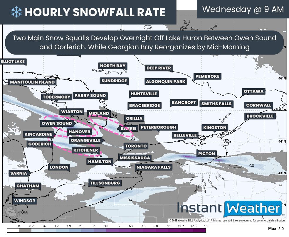
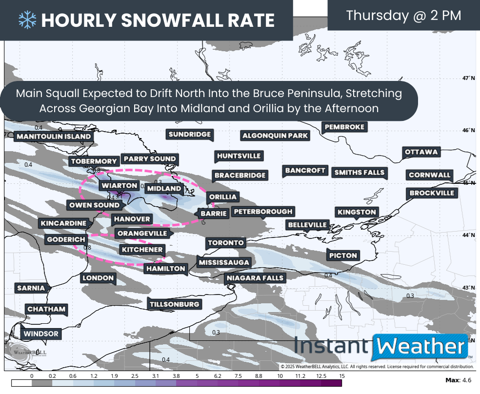
Hourly snowfall rates (cm) - MAP FROM WEATHERBELL
Overnight, snow squall activity is expected to consolidate into two primary bands between Owen Sound and Goderich. Meanwhile, activity off Georgian Bay may briefly weaken overnight, although confidence in that outcome remains low. Radar trends continue to show a very robust squall set up between Orillia and Barrie, and even if it temporarily diminishes, it is expected to redevelop by mid-morning Wednesday.
The southern Lake Huron squall may also stretch farther inland at times, potentially reaching areas like Kitchener and parts of the western GTA, bringing brief but intense bursts of snow and rapidly changing road conditions.
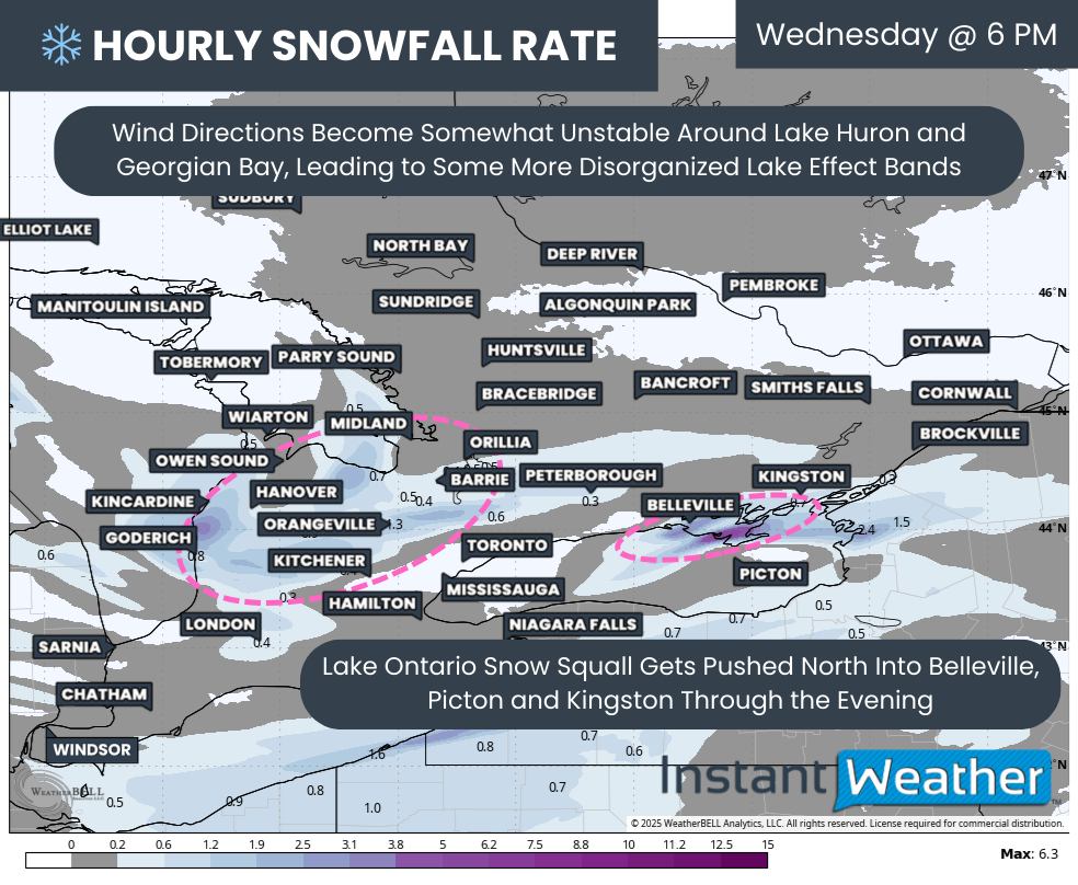
Hourly snowfall rates (cm) - MAP FROM WEATHERBELL
These squalls are expected to persist through Wednesday morning and afternoon. By Wednesday evening, a weak Alberta clipper will move through Southern Ontario, briefly shifting winds and causing lake effect snow to become more scattered for a time.
That same clipper will also cause a wind shift over Lake Ontario, which could push an organized snow squall northward into Belleville, Picton and possibly Kingston. Snowfall rates in this band could reach 4 to 8cm per hour, with total accumulations of 15 to 30cm possible before the squall exits around midnight.
Hourly snowfall rates (cm) - MAP FROM WEATHERBELL
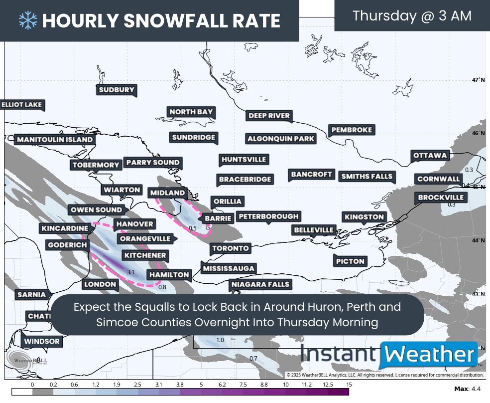
Snow squall activity should reorganize overnight into Thursday morning for regions east of Lake Huron and southeast of Georgian Bay as colder air deepens once again.
Based on the latest guidance, the strongest Lake Huron squall on Thursday looks most likely to set up somewhere near Kincardine, Wingham and Listowel, though this position could still shift. At the same time, the Georgian Bay squall is expected to continue hammering the Springwater and Barrie area.
Hourly snowfall rates (cm) - MAP FROM WEATHERBELL
By Thursday afternoon, the focus may shift northward as a multi-lake squall develops, stretching across the Bruce Peninsula, over Georgian Bay and into Midland and Orillia. Additional weaker bands may linger farther south across Huron and Perth Counties, including areas like Goderich and Stratford.
Looking ahead to Thursday night into Friday morning, the Georgian Bay squall may intensify further as winds become more westerly. This would allow the band to push northward into southern Muskoka, where it could lock in for much of the day Friday. A separate forecast focusing on Friday and the weekend will be issued closer to that time.
NOTE: YOU CAN CLICK ON THE MAP TO OPEN A ZOOMABLE IMAGE

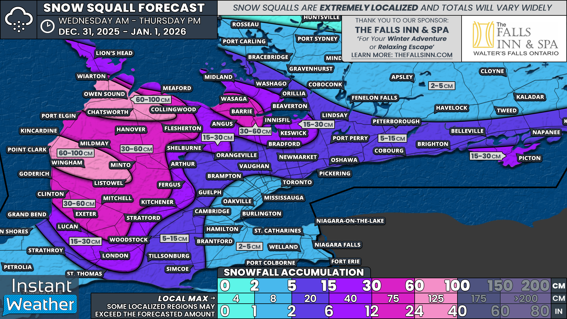
Before getting into final snowfall totals, it is important to remember that lake effect snow squalls are extremely localized. These narrow bands can produce massive snowfall in one community while areas just a few kilometres away receive very little. Forecast zones are intentionally broad to account for shifting winds and band placement, meaning not everyone within a zone will reach the listed totals.
With that in mind, there is strong model agreement on two primary zones with the highest snowfall potential ranging from 60 to 100cm, with localized amounts possibly exceeding 100cm if the most aggressive solutions verify.
The northern high-impact zone includes Owen Sound and Chatsworth, while the southern high-impact zone includes Point Clark and Wingham.
For the remainder of the eastern Lake Huron shoreline, snowfall totals of 30 to 60cm are expected, though isolated pockets could approach 75cm. Similar totals are possible from Wasaga Beach through Barrie, though totals there are more likely to remain on the lower end of the range.
Farther inland, areas including London, Woodstock, Kitchener, Fergus, Orillia, Innisfil, Keswick and Bradford could see 15 to 30cm. This is more conditional and depends on squalls stretching far enough inland in the right position.
That same 15 to 30cm potential also applies to parts of Prince Edward County, including Picton, where much of that snow could fall in a very short window Wednesday evening.
Surrounding regions extending southeast of London toward the Lake Erie shoreline, into Guelph, the north and eastern GTA, and along the Lake Ontario shoreline into Eastern Ontario could see 5 to 15cm by the end of Thursday. Most areas will likely stay closer to the lower end, though isolated pockets could approach 15cm due to intermittent lake effect bands.
The remainder of Southern Ontario, outside of northern Central and Eastern Ontario, can expect a general 2 to 5cm, mainly associated with the weak clipper system on Wednesday. Farther north, including the Ottawa Valley, less than 2cm is expected.


