Florida Braces for Catastrophic Landfall of Hurricane Milton; Potential to be the Most Destructive Hurricane on Record for the State
/
Satellite Image of Hurricane Milton from October 8th at 2:21PM EDT, Courtesy of National Hurricane Center.
Following its almost unprecedented intensification from a Tropical Storm to a Category 5 hurricane and becoming the 5th most intense Atlantic hurricane on record, Milton’s development was stunted overnight while undergoing an eyewall replacement cycle. During this, the inner structure of the storm changed significant, with the eye filling in and the wind field expanding. The peak winds fluctuated and Milton was downgraded to a Category 4 hurricane this morning.
With the eyewall replacement complete, the eye cleared and shrunk in size, marking the possibility it might regain some of its slight loss in strength and achieve Category 5 status once again. The latest Hurricane Hunter recon mission estimates that Milton is just shy of the threshold of becoming a Category 5 hurricane with maximum sustained winds of 155 mph (250 km/h). However, continued structural changes over the next 24 hours will result in further fluctuations in strength.

Forecast Track for Hurricane Milton, Courtesy of The National Hurricane Center.
Hurricane Milton continues its offshore passage of the Yucatan Peninsula, where it has brought significant damage to coastal areas. The storm has already made its predicted turn and begun moving northeastward into the heart of the Gulf, where it will increase its forward speed bringing it into Central Florida.
There has been very little change in the official forecast track from the National Hurricane Center (NHC), aside from the possibility that landfall might occur just south of Tampa Bay. This slight change is of little consequence because even at 24-36 hours out, the NHC forecasts have of a margin of error 60-70 miles so it is still difficult to pinpoint exactly where landfall will occur. Furthermore, Milton and its wind field are still projected to grow in size as the storm encounters vertical wind shear ahead of landfall. The area of hurricane and tropical storm-force winds is expected to double in size, spreading the threats of life-threatening surge, heavy rains, and destructive winds far beyond the forecast cone.
The NHC’s storm surge forecast for the Anclote River to Englewood, including Tampa Bay, has been increased to 10-15ft and could be double that from Hurricane Helene two weeks ago. With the area still recovering from storm surge damage that resulted from Helene, large piles of debris can be found all along the coast, posing a very unique threat. Not only will some of the debris get washed back inland with the storm surge, the hurricane-force winds could easily turn these remnants into dangerous projectiles when the storm hits.
In addition to the threat of storm surge and intense winds, central and northern portions of Florida Peninsula could see 5-12 inches (127-305 mm) of rainfall, with localized totals potentially reaching 18 inches (457 mm). These heavy rains will push far inland and elevate the risk of flash flooding over a large part of the state, especially in low-lying areas and along rivers. The Weather Prediction Center (WPC) has issued a High Risk (their highest level) for flash flooding across a large swath of Central Florida that includes Tampa and Orlando.
After landfall, Milton is expected to track across the Florida Peninsula and emerge into the Atlantic, where it will briefly remain a hurricane before transitioning into a post-tropical storm. However, the impacts to Florida and surrounding areas will be significant long before the storm weakens.
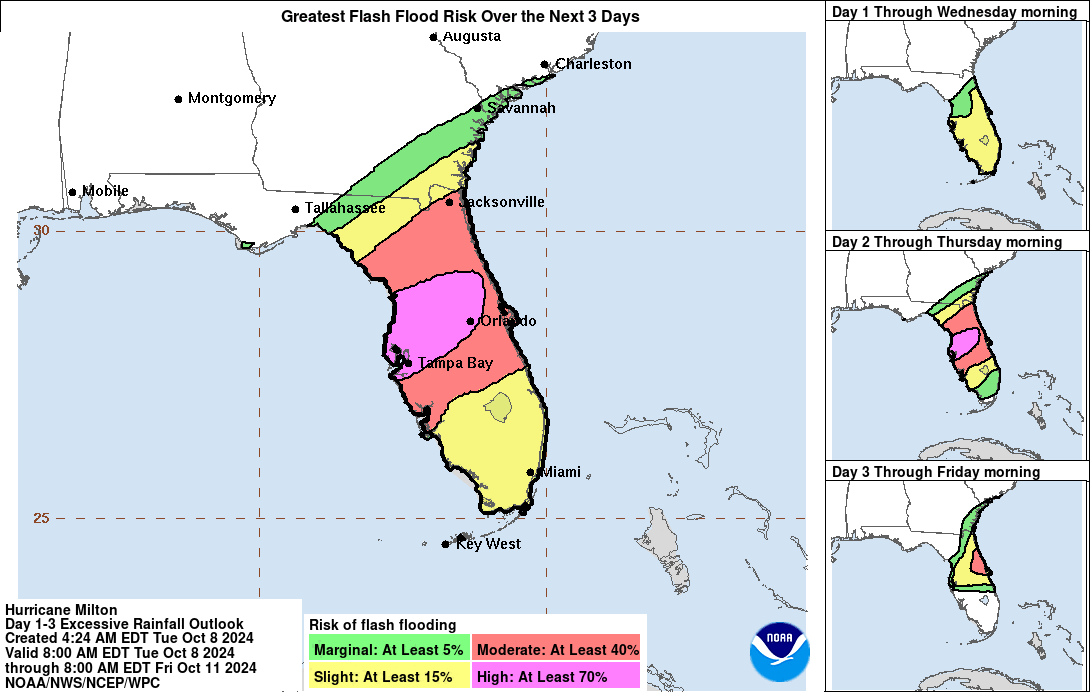
Flash Flood Forecast in Florida from Hurricane Milton, Courtesy of The National Hurricane Center.
Milton’s rapid intensification has been fuelled by its movement through an area of deep, warm waters, with sea surface temperatures exceeding 28°C, providing ample energy for the storm. Additionally, low wind shear in the region has allowed the hurricane to strengthen unhindered. Thankfully, we began to see that development stall overnight with the eyewall replacement cycle. As it continues to approach Florida, Milton is still expected to encounter an area of shear that will weaken it further, but it will still be a powerful hurricane at landfall. The NHC forecast maintains that it could make landfall as a Category 3 hurricane, with maximum sustained winds of 125 mph (201 km/h). However, they have stated that this projection is on the high end of model guidances so there is the possibility of an adjustment to this forecast in the next 24 hours.
The entire Florida Peninsula is now under a Tropical Storm or Hurricane Warning. Residents in the projected path are being urged to finalize their preparations while there is still time. Tropical storm-force winds are expected to arrive as early as tomorrow morning, with landfall projected overnight Wednesday. While uncertainty remains regarding Milton’s exact landfall location and strength, the potential for widespread heavy rainfall, destructive winds, and life-threatening storm surges is significant.
If you or your loved ones are in the storm’s potential path, it’s crucial to stay informed, heed evacuation orders if they are issued, and follow any directives from local emergency personnel. We will continue to provide updates as more information becomes available, so stay tuned. Your safety is the priority as Hurricane Milton approaches.

Forecast Track and Intensity of Hurricane Milton with Sea Surface Temperatures, courtesy of Tomer Burg.


