Significant Wind Storm Takes Aim at Alberta Starting Sunday Evening and Continuing Into Monday; Wind Gusts in Excess of 100km/h Possible

Strong winds that have developed Sunday afternoon are only expected to get stronger later in the evening and overnight across Alberta. This is courtesy of a system that is also bringing widespread snowfall to the province early Monday morning and lasting through the day.

We expect the worst conditions will pre-dawn on Monday with maximum wind gusts across Southern Alberta approaching 100km/h or even exceeding that in some areas. Wind damage along with some power outages are likely. The wind will begin to die down as we head into the afternoon on Monday although it’ll still be quite gusty throughout the rest of the day.

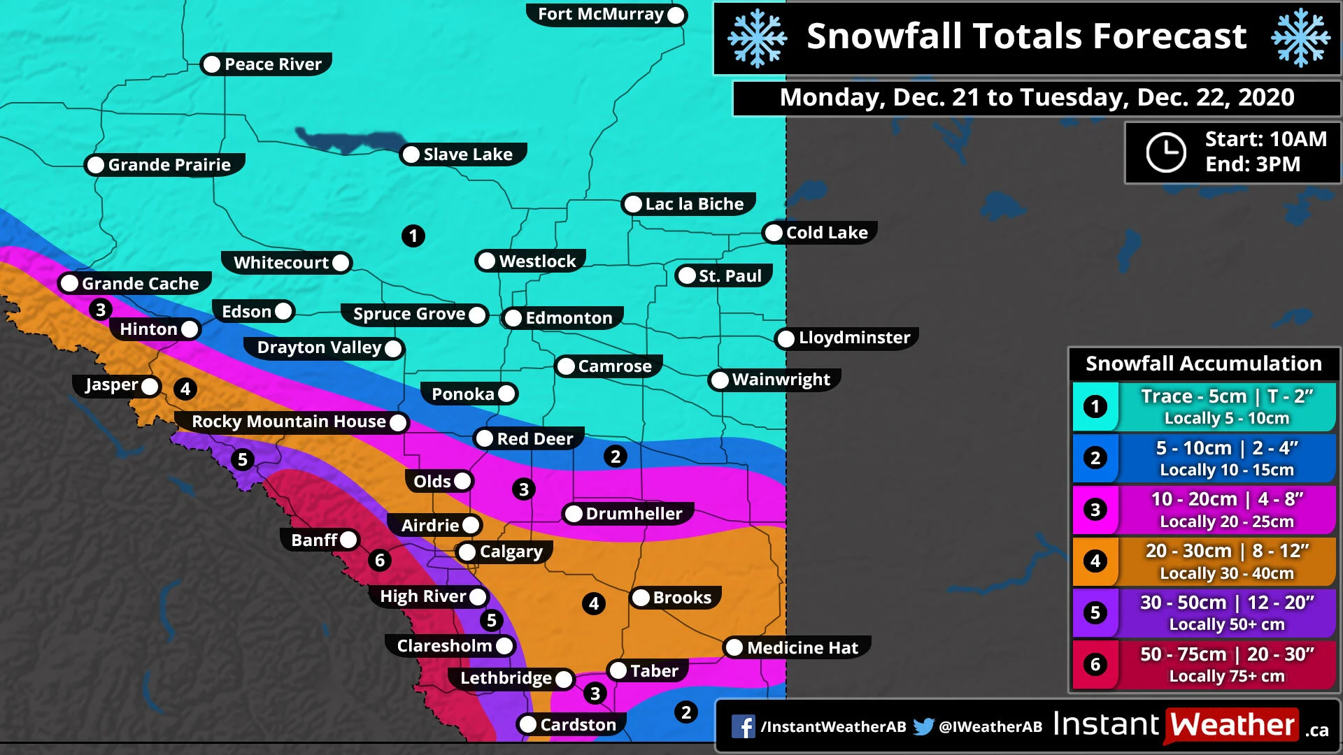
As far as the snowfall is concerned, we’re not expecting significant accumulation and most areas will see maybe 5-10cm of snowfall accumulation. Higher amounts in the Rockies which is fairly typical with between 25-40cm expected as per Environment Canada. However, the strong winds could create blowing snow and hazardous driving conditions while the snow is coming down during the morning hours on Monday. Please drive with caution!

Conditions will improve late Monday as the system moves out over Saskatchewan and Manitoba.

The Nightmare Before Christmas; Major Snowstorm Set to Dump Up to 50cm of Snow on Southern Alberta Including Calgary Between Monday and Tuesday

With only days to go until Christmas, a powerful snowstorm is setting its sight on parts of Southern Alberta beginning late Monday morning along the Rockies and later Monday for other areas. Heavy snowfall will be ongoing throughout the day on Monday and extending into Tuesday as moisture from the Pacific Ocean is drawn into the province.

To make matters worse, the low-pressure system bringing all this weather will further intensify causing wind gusts to pick up into the 40-60km/h range with stronger gusts overnight into Tuesday. Blowing snow and hazardous driving conditions are likely during this time so avoid all non-essential travel if possible. Snowfall will begin to come to an end later in the day on Tuesday as the system moves out over Saskatchewan although flurries will likely continue through the evening and maybe even into early Wednesday.

As with most snowstorm that affects Alberta, this will be a very elevation dependent storm when it comes to accumulation. The highest snowfall totals will of course be found through the Rockies to the southwest of Calgary including the Banff area with between 50-75cm of accumulation possible. A small area just to the south of Calgary that is slightly more elevated including the Foothills such as High River and Claresholm has the potential for between 30-50cm of snowfall accumulation.

Outside of the elevated areas, we expect between 20-30cm through the City of Calgary and eastward towards the Saskatchewan border including Brooks and Medicine Hat. Lower totals closer to 5-15cm is expected to the southeast of Lethbridge. And further north the accumulation will also be lower with less moisture to work with so Olds and Drumheller will see between 10-20cm while Red Deer gets around 5-10cm. Edmonton and Northern Alberta will see little to no snowfall from this event.

A White Christmas Appears Very Likely for Most of Alberta With Potential Snowstorm Monday Into Tuesday

This is a PRELIMINARY outlook - we will be updating it throughout the week as we get closer to Christmas.

This is a PRELIMINARY outlook - we will be updating it throughout the week as we get closer to Christmas.

Unsurprisingly, a White Christmas is basically guaranteed for the Rockies into the Northern parts of Alberta. There is a significant snowpack in this area and it will likely only continue to grow throughout the week with more snowfall accumulation. For the lower elevations of Alberta into Calgary and Edmonton, it looks like a White Christmas will probably happen but it’s not guaranteed. This is due to a limited snowpack going into the weekend and temperatures several degrees above the freezing mark on both Saturday and Sunday. Calgary and Edmonton will likely have very little snow on the ground by the end of the weekend.

For those who are hoping for a White Christmas, we have good news that a system is expected to deliver a blast of accumulating snowfall to Alberta including Calgary and Edmonton between Monday and Tuesday. Between 10-20cm is possible from this storm with higher amounts along the Rockies. Calgary will likely see lower snow totals between 5-10cm though that may change. We’ll have a more detailed forecast as the event draws closer. With this storm and temperatures expected to stay below the freezing mark from Tuesday through to Christmas Day, a White Christmas is very likely.

Now we have decided to give a small zone in Extreme Southern Alberta an equal chance of a White Christmas. This includes Lethbridge and Cardston mostly because they may not see much snow from the storm early in the week and above freezing temperature until Tuesday. We will have to see how this develops in the coming days and once we get to Monday or Tuesday it should become clear if they’ll see a White Christmas or not.

On behalf of the entire Instant Weather team, we’d like to wish everyone a happy and joyful holiday season! We’ll continue to be here keeping you informed on any impactful weather over the holiday season and into the New Year. Here’s hoping that 2021 is much better to everyone than the dumpster fire that 2020 has been! :)

Major Snowstorm on the Horizon for Southern Alberta This Weekend; Blizzard Conditions and Up to 30–50cm of Snow Possible

Winter is getting well underway across Alberta and that will continue to be true as we head into a very active weekend with multiple rounds of snowfall blasting parts of Southern Alberta. The worst conditions are expected late Saturday into Sunday as a strong low-pressure system tracks into Saskatchewan with very heavy snow recaching into Southern Alberta. Wind gusts between 50-75km/h are also expected to develop at the same time which no doubt will create hazardous driving conditions out on the roads due to blowing snow. The criteria for a blizzard may be reached in areas such as Lethbridge, Taber, Brooks and Medicine Hat creating whiteout conditions. When all is said and done, we’re looking at as much as 30-50cm of snowfall accumulation by Monday in the above-mentioned regions with local amounts potentially exceeding 50cm in the higher elevations around the Pincher Creek and Cardston area.

Wet snowfall mixed with rain has already started to affect areas near the International border and that is expected to linger into Saturday as temperatures hover a few degrees above the freezing mark. At this point, accumulation will be fairly light given that it will be wet snow and most of it will melt on contact. The exception to this is the higher elevations southwest of Lethbridge that are already near the freezing mark and is expected to remain that way throughout the weekend. Further to the north, the Edmonton and Lloydminster area will see moderate snowfall during the day on Saturday from this first round and the temperature will be several degrees below the freezing mark so it should have no problem accumulating. We expect this first round of snow to move off into Central Saskatchewan sometime during the evening hours on Saturday as a more potent round approaches from the south. Accumulation after the first round will generally range from 10-15cm including Edmonton and less near the border where some of the snow will melt with that Pincher Creek and Cardston zone seeing over 20cm.

You might be thinking that this ‘storm’ isn’t that bad by the time you get to Saturday evening but don’t be fooled! The worst is yet to come as temperatures plunge overnight Saturday with the snowfall rate picking up as heavier bands of precipitation reach the southern part of the province. This is also when we’ll see wind gusts start to increase reaching 50-75km/h around the midnight hour. These gusts will continue through Sunday morning and afternoon as the snow only continues to get heavier. Travel is strongly discouraged during the day on Sunday in the hardest-hit regions as near-zero visibility on the roads along with rapidly accumulating snowfall will be occurring during this time. Conditions will begin to slowly improve late Sunday from west to east with the extreme southeast corner of the province (Medicine Hat area) being the last region to see conditions improve. The system will fully move out of Alberta by midnight leading to a clear start to the week as you wake up Monday morning to clean up.

As far as accumulation goes, totals for the entire weekend including both rounds of precipitation will vary significantly throughout the province. We expect the highest totals in a zone around the US border including Pincher Creek and Medicine Hat where the accumulation will range from 30-50cm and potentially more than 50cm in some localized areas. Surrounding regions including Claresholm, Lethbridge and Brooks will likely top out at around 20-30cm although the potential is there for this zone, in particular, to overachieve the forecast depending on where the bands of snow end up. A fairly expansive zone stretching from High River through Central and Southeastern Alberta including Edmonton, Drumheller and Lloydminster will see between 10-20cm. And finally, we currently have the Red Deer and Calgary in the 5-10cm zone but there’s high uncertainty as some models show Calgary getting less than 1cm of snow while others have over 10cm so it could be higher or lower than our forecast.

Stay safe this weekend and if possible just stay home and off the roads. If you must travel, be sure to drive according to the conditions.