Blizzard To Slam Much of the Island With First Big Snowfall of 2021!

Issued: January. 21, 2021 @ 12:10 PM

Updated: January. 21, 2021 @ 12:10 PM

Forecaster: James Follett

Winter Storm II.jpg

The first big snowstorm of the new year 2021 is now already approaching the province with some light snow and increasing winds, making it look lovely for now, but it’s about to look like a marshmallow world in the city! The heavy snow will quickly move in later this afternoon and evening hours, with the worst conditions between 5pm and 11pm on the Avalon Peninsula, but the moderate snow will continue through the overnight and continue into the early morning with periods of light snow still continuing to fall through the day, and even continue all the way into the weekend!

NFLD Storm Timeline.JPG

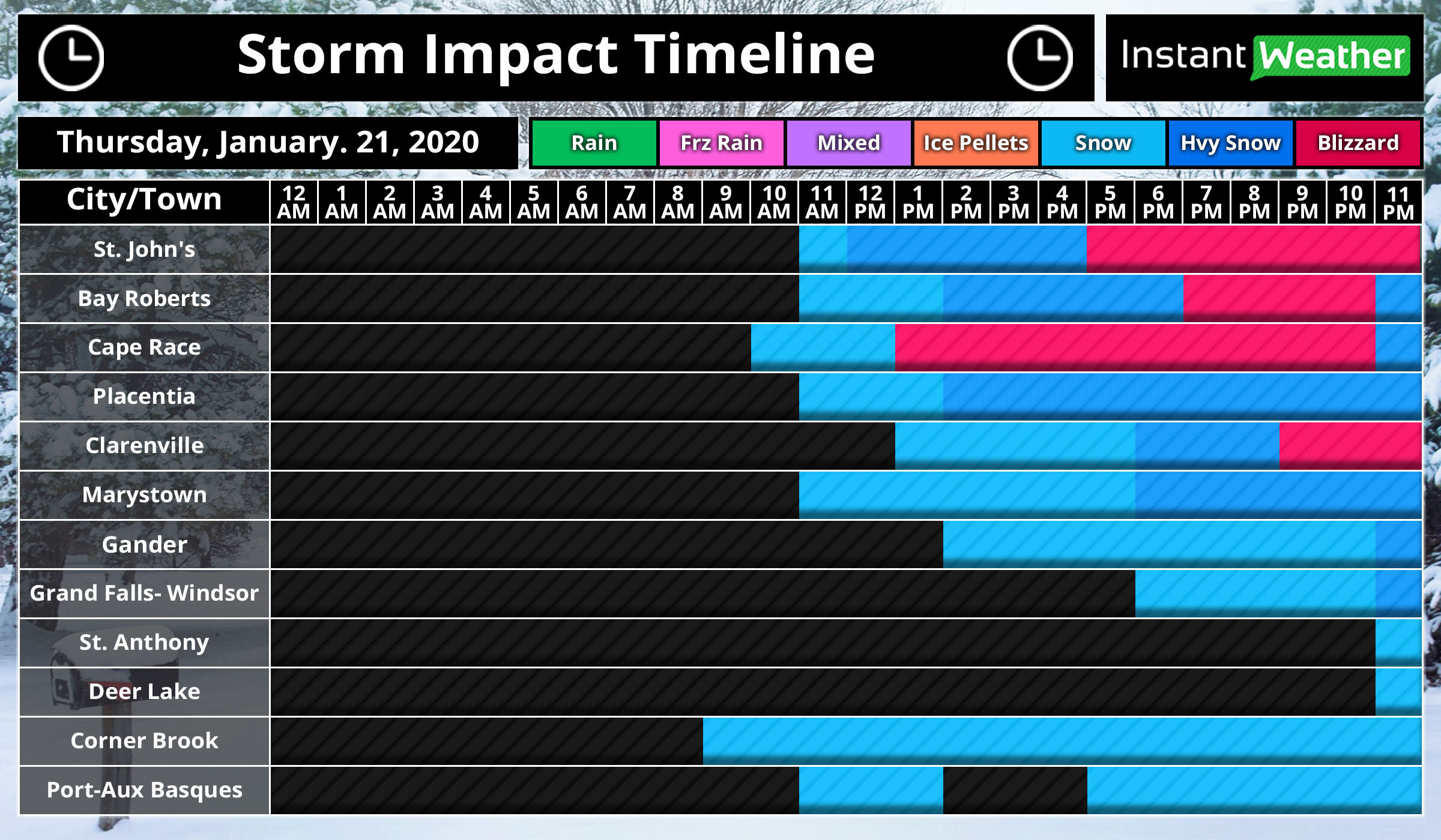
The storm has arrived on time right around the noon hour for St. John’s, we will expect that snow to quickly become steadier and heavier as the next few hours go by then it really gets bad by the time we get into the supper hour! Between 5 pm and 11 pm, we could see blizzard conditions!

The further west you go, the later the snow will arrive for you! Gander, Grand Falls- Windsor will see the snow starting later in the afternoon and early evening hours and by the time you reach St. Anthony & Deer Lake, expect the snow to not start until near 11 O’clock tonight!

On and off snow continues today for Corner Brook and Port-Aux-Basques.

Video Block
Double-click here to add a video by URL or embed code. Learn more

As can see by the radar, and futurecast, the snow has already engulfed the entire Avalon Peninsula and will continue to spread north and west through today and tonight as it increases in intensity. You may also notice that when playing the radar, the rain/snow and mix line gets rather fairly close to the southeast near Cape Race. I wouldn’t rule out the possibility of some Freezing rain or Ice pellets in that area later this evening. If it does then snow amounts will likely be a bit lower than forecast and some tweaks to the snow map may be needed.

NFLD Storm Winter storm threats Peninsulas 1.JPG

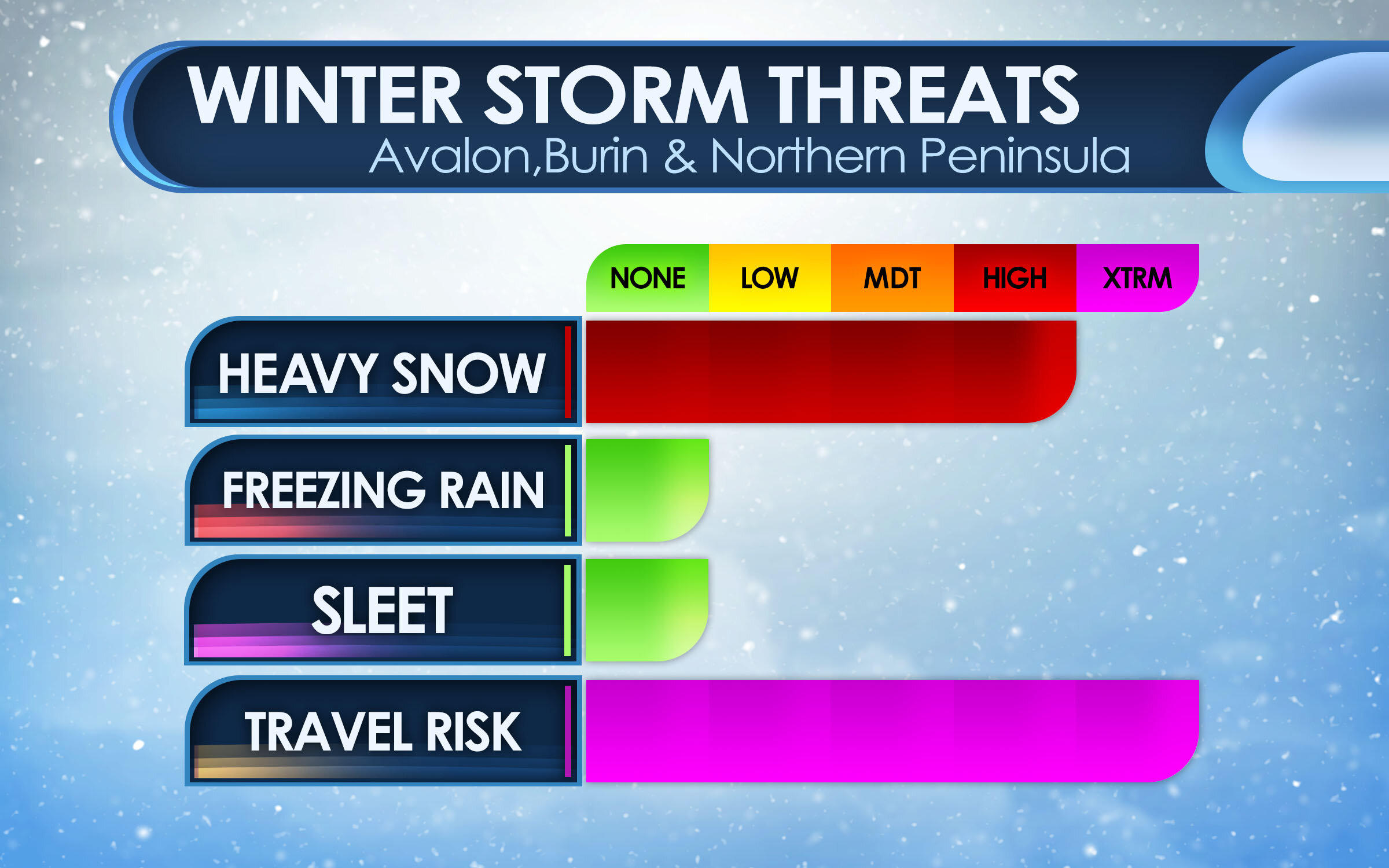
Here are the main threats with this winter storm, for the Peninsulas of Avalon, Burin and Northern Peninsula. The main threat is the Heavy snow and Travel risk! We are looking at high snowfall rates as much as 5-10cm per hour at times, many models put 40cm for St. John’s and surrounding areas. the heavy snow and combined strong wind gusts of 80-100 km/h will create blizzard conditions which will result in very hazardous travel, and for that reason the Travel Risk is at Extreme.

Central Winter Storm Threats.JPG

For Central areas, The impact is less severe as the storm will be a bit far, and the heaviest snow will miss. However, there still will be a lot of snow and strong gusty winds causing low visibility! a Moderate risk for Heavy snow, but it’s that Travel Risk that is the main Hazard! A very High Hazard, with as much as 15-25cm can fall in that area.

Avalon Peninsula Travel Risk.JPG

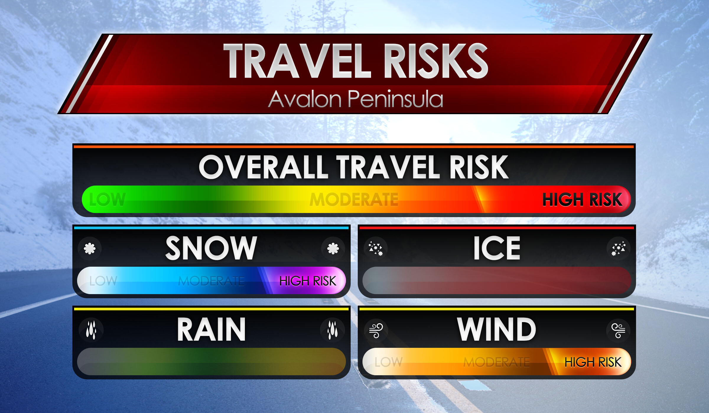
Here are the main risks for your travel risks! We’ll start with the Avalon Peninsula as that will be the hardest hit areas! Biggest risks are Snow & Wind, as we are on the colder side of the storm, snowfall amounts as much as 30 to 40cm can fall by Saturday morning! Whipped up by a high risk for winds as winds top 80-100 km/h. This will cause extensive blowing and drifting snow causing extreme low visibilities and Blizzard conditions, Overall Travel risk for the Avalon Peninsula is at High.

Burin, Northern & Central Travel Risk.JPG

We now go to the Burin, Northern Peninsulas and Central for travel risks. High risk again of course for snow! snowfall amounts of up to 25cm possibly more can fall by the weekend. We also will have gusty winds, however the winds will not be as severe as the Avalon, but will be gusty and blowing and drifting snow will still be a factor, but likely not at blizzard condition level. The risk for wind is at Moderate, and that is what the Overall travel risk is, at Moderate.

NFLD Winter Storm Hazards.JPG

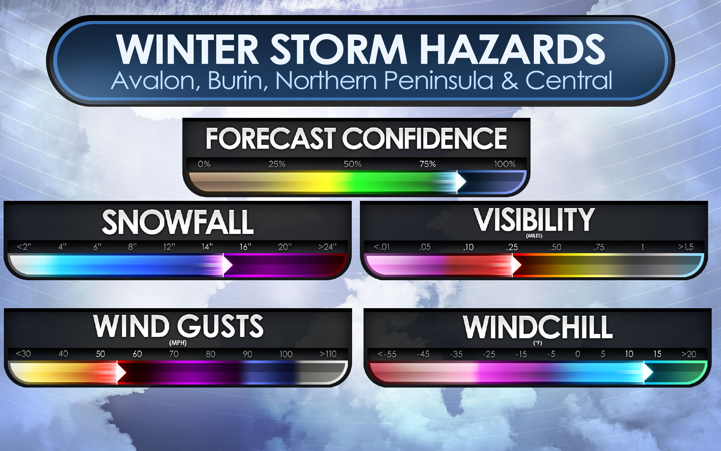
As we take a look at Threats and Travel risks, we now go to the Winter Storm Hazards! Main hazards are Snowfall, Visibility, Wind Gusts and for some, wind chill.

Snowfall: For the Avalon Peninsula, a good swath of 30 to 40cm is expected, however extreme western parts of the Avalon may see a little less in the range of 20-30cm. For Burin and Northern Avalon. as much as 10-20cm can fall and up to 30-40cm for the far northern areas. Central can see up to 25cm of snow, but lesser amounts as head south. Overall, snowfall hazards is up to 30-40cm or as much as 14-16”!

Wind Gusts: Strong wind gusts will also accompany this storm! winds of 40-60 sustained will gust to 80 to 100 km/h. this will create some property damage but most of all, the extensive blowing and drifting snow that will create white out conditions at times and blizzard conditions. Winds in the Avalon are expected to reach as high as 80 to 100 on the coast, or 50-60 mph.

Visibility: With the heavy snow and strong wind gusts, there is bound to be very low visibility… which is what is to be expected! visibility of near 0 is expected, and lot’s of times as low at 10 miles for several hours. Blizzard conditions would worsen the visibility, especially in white outs.

Wind chills: With temperatures below 0 and winds expected to clock over 40 sustained, wind chills of -10 to -15 degrees C, is likely and this could lead to a risk of frost bite. and with power outages likely, it’s a good idea to have a generator, or if have wood stove, have extra wood inside! If no generator or stove, have extra blankets and candles to try and keep warm.

NFLD Storm Snowfall map.JPG

Ok, let’s now go over the Forecast maps. We’ll start with the snowfall map. Starting with the Avalon! much of the eastern side will see the most with up to 40cm of snow expected including in the city of St. John’s and down to Cape Race. In the middle there is 20-30cm expected, then as get to the western side of the Avalon Peninsula, you have 12 to 20cm expected with locally up to 25cm that includes for the town of Placentia, Clarenville, and Gander. Blizzard conditions are possible for all of the Avalon Peninsula and including Northern sections from Clarenville to Gander.

For the Burin Peninsula! In the southern parts, such as Fortune and Grand Bank, you can look at only 2-6cm or locally up to 10cm. this is not a big storm for you! head north, however, towards Marystown then you will get into the higher snowfall amounts, of 6 to 12cm with locally as much as 16cm. This also covers much of the central parts of the province including Grand Falls- Windsor.

For Northern Peninsula, 12-20cm expected for Clarenville and even further amounts as head north, with up to a foot expected.

Central: not much snow expected unless going far northern central. expect 2 to 12cm with locally up to 16cm.

Western: Depends where in the west you are, the farther north you go the more snow you will get and the further south, the less you get. Stephenville, Corner Brook, and Deer Lake can see only 2-6cm with locally up to 10cm. But travel too far, far North all way up to good ‘Ol St. Anthony! then you could be talking about a good foot or more of snow!

NFLD Storm Wind Map.JPG

With this storm, the strongest winds will be on the Avalon and Northern parts of the province. But mostly the Avalon!

Avalon: Winds of 70-80 km/h is the expected forecast gusts from St. John’s to Placentia, however, on the South-Eastern tip could see Gusts approaching 80-100km/h, and the extreme North-Western tip will see 60-70 km/h wind gusts, this also spreads out into Clarenville & Gander as well as Stephenville.

For the rest of the province, looking at Gusts of only 40-60 km/h, lesser winds for the Southern sections near Port-Aux- Basques.

NFLD Storm Power Outage Map.JPG

When you have heavy snow and tropical-storm-force winds, you get the talk of power outages! Right now the Avalon Peninsula and the Northern parts of the province are at the highest risk of seeing Outages likely and even a wide swath of Widespread outages on the Avalon. Placentia, Clarenville, and Gander you can see outages likely due to heavy snow and winds. Where lesser wind and snow is expected, the outages are only possible over parts of Northern Burin Peninsula and Central including Grand Falls Windsor.

We could see some Isolated outages over the southern tip of the Burin and parts of western Central, elsewhere, there are no outages expected for tonight or tomorrow.

We will have more on this storm as we go through the day and night.

Be Safe, Be Well, Buh-Bye!!

~ James

Your Windshield Wipers Will Be On High as Cat and Dog Rainfall Arrive , Screaming Wind & A Few Slushy Inches

Issued: November 23, 2020 at 12:40 AM

Updated: November 23, 2020 at 6:50 AM

11 PM Late Evening Update

Forecaster: James Follette

Heavy Rain I.jpg

Good Evening! Another Storm system is on its way towards Atlantic Canada for the start of the new work week with Heavy soaking rains, Strong to Damaging Winds & yes, even some snow! with the potential for blowing snow and blizzard-like conditions.

Monday, November 23rd.

NS Mon 11 AM Map.jpg

Rain will begin to spread into the Southern portions of the province early tomorrow morning from 7am in Yarmouth to 11am in Halifax and surrounding areas, This rain will be the first outer bands so it will be a light rainfall.

NS Mon 5.30 PM Map.jpg

As we fast forward into the early evening hours, at around 5-5:30pm The rain will become more moderate over Eastern areas from Liverpool to Halifax, still fairly light through Digby & Yarmouth. Rain spreads into Northern Nova Scotia, almost entering Cape Breton.

NS Mon 8.30 PM Map.jpg

By Late evening hours tomorrow, we will begin to see that heavier rain moves into the Southern portions from Yarmouth to Halifax by 8 pm and Light rainfall spread elsewhere in the province, a more moderate rainfall as you may notice by the amount of rain falling on the map from Halifax to Antigonish and New Glasgow, that is Moderate rainfall occurring.

NS Mon 11 PM Map.jpg

Now at 11pm nearing Midnight, we see the Heavy rainfall continue in the South and spread North of the province, only Cape Breton seeing some Moderate rainfall.

Tuesday, November 24th

NS Tues 2AM Map.jpg

As we enter the early morning hours of Tuesday, The 2 systems will move a bit more quickly to taper off the showers and rain for Yarmouth and much of Shelburne, parts of Digby county as well. but light rain or showers will persist for Liverpool to Kentville and a more soaking rain for Halifax to New Glasgow and as far North as Sydney.

NS Tues 5AM Map.jpg

As many will wake up near 5 and 6am on Tuesday, the entire Southern portions will be dry and done with the rain and the rest of the system in fact! Few sprinkles in Halifax may linger and showers will persist into Truro and New Glasgow & Amherst with heavy rainfall persisting in Antigonish and Sydney.

NS Tues 8 AM Map.jpg

As we get later into the morning hours, by 8 am the system begins to accelerate and much of the province would be out of the woods for any more rainfall, in fact, much of Nova Scotia with the exception of Cape Breton should have a fairly beautiful day Tuesday, despite the cold breezy winds that will stick around. Cape Breton will be seeing continued rainfall here at 8 am.

Monday Storm Timeline

NS Monday Storm Timeline.jpg

Let’s now take a look at our storm timeline! We’ll start with the Southern portions first!

So in the Tri-Counties and South Shores, look for your rain to start very shortly this morning in the next few hours, between 7 and 8 am will be the first drops! and continue on to midnight.

For Mainland areas, New Glasgow, Halifax, Dartmouth, Greenwood & Kentville first drops falling near 10 or 11 am.

For Northern sections. Cheticamp and Sydney, your rain will not start until later this evening at around 8 pm. Cheticamp may see a brief period of flurries or light snow at 2 pm this afternoon from an onshore flow.

Tuesday Storm timeline

NS Tues Storm Timeline.jpg

As we forward into Tuesday now! Rain will begin to end in the overnight hours by 2 or 3 am Tomorrow morning for much of everyone with exceptions to Greenwood and Kentville where your rain may linger into 5 AM.

The cold air will rush in here like racing horses at the track fighting each other for a win. This will send rain turning into the snow for Mainland and Northern sections. Halifax, Dartmouth you can see a brief period of snow from 8 am into 11 am tomorrow morning. Kentville can see quick brief snow at 8 am tomorrow morning.

Rain ends for Sydney at 10 am tomorrow morning, so for much of the province, by the time we get to mid-morning tomorrow, the storm is done with. In a way, it is, however, look at Cheticamp where the precipitation just keeps going for another 24 hours and changes to snow by 9 am and just persists into midnight. That is the back end flow of that storm taking advantage of that bitterly cold air above and just keep the snow and snow squalls persisting much of Tuesday.

Wednesday Storm Timeline

NS Wed Storm Timeline.jpg

Now we are into Wednesday, Only place getting precipitation is Cheticamp and surrounding areas. Snow persists all way into early morning and ending by 6 am. So looking at a long period of snow from 9 am Tues to 6 am Wed. This will be the reason of the high snowfall amounts for this area.

Rainfall Amounts through Tuesday

NS Total Rain Map.jpg

Now looking at the Rainfall amounts we can expect through out Tuesday. Much of province looking to see 20-30 mm with local areas likely to receive 40 mm, Greenwood, Kentville, New Glasgow, Sydney you will all see a bit less rainfall with amounts of 10-20 mm with local amounts up to 30 mm. Then finally for Western Cape Breton.. going to be hardest hit area with up to 50 mm of rain and potential local amounts up to 70mm, and perhaps even a bit higher than that! this is before the change over to snow!

Ugh! Snowfall Amounts!

NS Snowfall Map.jpg

If there is any good news in this forecast, is that not everyone will see snow! Some Flurries are expected through parts of Digby and Kentville and then a widespread path of snowfall from Amherst to Antigonish and Sydney and these areas will see amounts of only up to 2cm! maybe some local amounts up to 4cm.

But the heaviest snow is Western Cape Breton! where the snow will fall for a very long period of time, into Wednesday morning. amounts of up to 6cm, some local amounts up to 10 cm.

The snow is not the bad part… it’s the wind! We are looking at very strong to damaging winds in Cape Breton along with Les Suetes! This combined with a long period of snow, at times heavy will create blizzard-like conditions!

The big bad wolf's breath… Blowing very hard! May cause some damage!

NS Wind Gust Map.jpg

Finally last but not least! the winds! Winds will Gust pretty strong across the province, but Northern parts will see the really big winds where you can see some power outages and damage to roofs, shingles, windows, property, Christmas Decor.

Much of province will see a good gusty wind of 70 to 80 km/h this includes from Yarmouth all way up to Halifax and near Antigonish.

Amherst, New Glasgow, Antigonish… you make it up to level 4! ;) congrats! that means you get to see winds from 80 to 95 km/h.

Majority of Cape Breton with the exception of Western Cape Breton… Level 5, is where you get to see the beginning of some slight wind damage. Gusts of 90 to 105 km/h.

And Western Cape Breton, this is the jackpot! Level 6 on our Wind Guage chart! Wind Gusts exceeding 100 to 115 km/h! This is where you will see nasty blizzard conditions, Blowing snow, windswept rain, large waves, power outages, and property wind damage.

We will have more on this system throughout the morning so keep checking back with us on IW Nova Scotia on Twitter and Facebook, and of course on our app! Just download the IW app, and you can check out our amazing radar! and hour by hour forecast and your long-range and any alerts or updates issued!

More coming up later this morning on this gloomy Monday, But try and love and shine bright!

Be safe! Wear your mask! Keep your distance! & wash your hands!

Love and light from us here at IW Nova Scotia.

Winter Storm! Snow for Vancouver, As Much as 2 Feet! Over Higher Terrains and Mountains

Issued: November.11,2020 @ 5 PM

Updated: November.11, 2020 @ 5 PM

Forecaster: James Follette

Winter Storm.jpg

Good Afternoon! We have a lot to talk about in today’s forecast! Although for many areas around the province it’s a nice sunny but cold day! We also have some showers that came through Victoria and Vancouver over the last few hours, The RGEM FutureCAST model has done a really good job in forecasting that.

Last night, I was leaning more on the NAM and ECMWF model, but now that I see the showers came about as the RGEM and GEM model forecast.

This doesn’t really change much in the forecast for the lashing winter weather we are about to get!!

A very strong and moisten storm will begin to arrive very late tonight into the day Thursday and then another storm comes in on Friday through Saturday morning.

So there are 2 separate storms and both of them will deliver something different to some parts along with Vancouver.

Storm 1: Late tonight into Thursday, Heavy snow at times for Inland Vancouver and Metro, Downtown Vancouver could even see a few slushy inches! But head far inland towards the North district of Vancouver and Port Moody to Coquitlam that is where you could see several inches of snow!

Along with the snow, is the heavy rain that would lash the coastal areas with as much as 50 to 75 mm of rain by the time that Saturday morning rolls around.

Winds will not be too strong as they will mainly stay south, but Gusts to 40-60 km/h is very likely.

Storm 2: Late Thursday night into Saturday morning, Heavy snow will continue to fall in the very high elevations and far inland. But snow will become rain over much of the entire Vancouver area, Snow in the mountains will continue to pile up, seeing as much as 2-3 feet! in lower elevations inland, up to 15-30cm is expected! The Interior could see another 5-15cm.

Rainfall will continue to fall on the coast, and become a bit heavier.

Winds will be stronger in this storm, gusting up to 80 km/h in Vancouver and Victoria and along the coast. Inland can see gusts up to 70 km/h.

So with all this rain, snow & wind, it is very likely we can see power outages.

rgem-all-vancouverski-instant_ptype_3hr-1605117600-1605128400-1605420000-10.gif

Looking at the FutureCAST timing this out over the next 3-4 days. This is the RGEM model and it’s doing a pretty good job so far in today’s forecast!

So Nice today, other than some flurries far inland and a few showers in Victoria and Vancouver. The heavy rain and snow arrive in the early hours of the morning so expect snow for inland Vancouver, a mix to mostly rain in the Metro of Vancouver and along the coast, Victoria will stay all rain for both systems.

The next system is a bit stronger and will sink south of Victoria, this will bring wind-driven rain for much of Vancouver and along the coasts & islands. But snow at times heavy will continue to fall for far inland areas and mountainous terrain.

By Saturday morning we finally begin to clear up a little.

rgem-all-vancouverski-total_snow_kuchera-1605117600-1605121200-1605420000-10.gif

Here is the models’ projection on snowfall over the next 3 days into Saturday, notice the bright pink-purple like colors? that is amounts of over 2-3 feet! This will fall over the higher terrains and mountainous areas. But Vancouver Inland… 5 to 15 cm over the North District of Vancouver, a few inches for the Metro and as head far north of Vancouver District, up to 30cm can fall! Vancouver Island Inland areas could see as much as 25 to 30cm of snow, coastal areas near the water will see much less with amounts of up to 5cm.

for the rest of the province, here is what you can expect in possible snowfall.

rgem-all-albertabc-total_snow_kuchera-5420000.png

Interior can see as much as 15cm, possibly more can not be ruled out! Further north more to the east, you will see far less snow, as the system will ne further away from you, Amounts of a few cm’s.

BC Snowfall Map.jpg

Here is what you can expect in my snowfall forecast!

Vancouver Island: 10-20cm with locally up to 25cm in the inland areas.

Inland Vancouver, Whistler, and Squamish to Hope you will see the highest amounts! depending on where you are, the higher up you are in the elevations the more snow you will get and those areas will see up to 50cm and lower elevations could see just 25cm.

For the Interior and much of mainland BC, look for about 5 to 10cm, however, could be some local amounts of up to 15cm.

Then we get to the Rockies into AB border, expect upwards of 30cm with local amounts near 40cm.

rgem-all-vancouverski-total_precip_mm-5420000.png

With the 2 combined storms, there is going to be a lot of precipitation water! now this includes all types of precipitation including snow! The areas that will see rain, such as along the coasts and in Vancouver, Vancouver Island Coastal areas. a good 50 to 75 mm of rain will likely fall by Saturday morning.

rgem-all-albertabc-total_precip_mm-5420000.png

For rest of BC, look at a good 10-30 mm of water in snow form! and with super cold temperatures far north and over mountains and high elevations that will produce a very high snow ratio and that is why the amounts are higher in those areas. The colder it is, the more snow will fall!

BC Rain Map.jpg

Here is my thoughts on the rainfall amounts through Saturday, A wide swath of a good 30-50mm with locally up to 70mm! And honestly, with the models being in a good agreement on showing 50 or more, I may tick that up in tonight’s forecast from 30-50 to 50-75mm. Either way, expect a flooding rain! You are wanting to make sure to unclog your storm drains so that the water call flow down into the sewer and not get clogged and create street flooding.

BC Remembrance Day Forecast.jpg

So for today, expect a chance of flurries or rain showers as that has been the case this afternoon from Squamish to Vancouver and for the South-East parts of the province.

BC Thursday Map.jpg

Then we get into Thursday!, There is that Low pressure just near Vancouver Island. A good soaking rain much of the coast, Very heavy snow inland and it will also be breezy at times with gusts up to 40 or 50 km/h. and from Prince George to the Okanagan looking at some Flurries.

Friday BC Storm.jpg

Then we have storm #2 for Friday! Low pressure over Vancouver island will sink south and curve up the coast. A nasty snow storm for Vancouver Island, and many parts of the coast, with exception of near Vancouver will you will be all rain!

Parts of the Interior from Kamloops to Hope, can look at a steady snowfall with blowing snow and potential blizzard conditions at times.

Strong winds on the coasts will gusts upwards of 60-80 km/h and that will create some blizzard conditions.

24 hour regional forecast.jpg

For the rest of today, expect sun and clouds for much of everyone, except some flurries in Kelowna and even some showers in Vancouver and Victoria late this afternoon and evening. Storm arrives in Vancouver to Victoria later overnight with a mix bag in Vancouver and rain in Victoria. Highs of 4-7 degrees, and lows tonight dipping down to -5 in Kamloops to as warm as +3 in Victoria.

BC Today forecast.jpg

Here in the city, expect gorgeous sunshine today, however again there is that shower chance in the afternoon hours. highs on the chilly side! only 3-6 degrees. South-West winds on the light side at only 5-10 km/h.

BC 24 hour forecast.jpg

Today, Sunny & cold with a chance of showers late in the day, high of 6. a slight chance of rain-snow mix overnight tonight with lows dipping down near the freezing mark at 1 degrees.

Vancouver 7 day.jpg

Here is your 7-day forecast, We are nice today, slightly breezy and cool with possible showers on the coast. high of 7. Colder tomorrow with a winter storm on our steps, snow inland, rain/mix on the coast. cold! highs only around 5 degrees!

Storm# 2 arrives on Friday, this time it is all rain and gusty winds to 80 km/h. That rain byway will be very heavy at times and some flooding is likely. milder at 7! lows of 4.

We continue to warm up on Saturday with lots of clouds but the precipitation stays far to the North sand South of us to not give us a bother. Sunday is also dry and slightly cool at 7. So your weekend is dry and cool but not a stormy one like Thursday & Friday so the weekend will be a great time to get out.

And getting out on the weekend will be a great idea because look what is coming for the start of the new week! YUP! another storm, this one though is all rain, lot’s of it! more flooding problems, strong winds. But the best part is that it is not a very cold rain, in fact, the temperatures will rise into the low 10’s!

I’ll have a better update on the 2 storms, and your latest updated forecast! coming up later tonight!

Have a safe Remembrance day, Remember to wash your hands, keep 6ft apart, and wear a mask! The more people that do this, the more quickly we can go back to normal!

Be safe, Be well, Buh-Bye!

You Will Have Plenty of Snow to Make Snow Cones!!!

Issued: November 9th, 2020 @ 10:30 PM

Updated: November 9th, 2020 @ 10: 30 PM

Forecaster: James Follette

BC Snow Map.jpg

The barometer is diving, the northerly winds are blowing, and the flakes are flying as of early this evening. Snow from the Fraser Valley to Osoyoos continues to pile up this evening and the snow will continue to fall well into the morning hours of tomorrow.

As much as 20+cm of snow can fall over much of the Interior and Fraser Valley from Prince George all the way down to Kelowna. There could also be amounts of up to 20-25 cm over Whistler. For the rest of the mainland, It looks like a good 6-12cm, however local amounts of up to 16cm is not out of the question.

For the coasts, Vancouver Island and the Metro of Vancouver, it looks like just a few slushy inches or up to 4cm, however further north in higher elevations of Vancouver could see local amounts nearing 6-10cm.

Vancouver Island can see as much as 10cm locally.

rgem-all-albertabc-instant_ptype_3hr-1604966400-1604977200-1605268800-10.gif

The white stuff is all thanks to a frontal low pressure and a low pressure over Northern Alberta, these two lows are sending cold arctic air down to the far south.

The weather will improve by Tomorrow afternoon, with scattered flurries still being a possibility, but the main snow will be done with.

High pressure takes over the province on Wednesday, but it will be located to the North West of us which means the winds will be coming from that area where it’s cold. So while it will be a beautiful day, there will also be some very chilly temperatures.

Another low pressure off the coast will impact coastal parts of the province Wednesday night into Thursday with more rain and snow & likely some gusty winds.

But a much bigger storm will arrive on Friday, with very low pressure, a pressure center of 968mb, So if you have a Barometer at home, the 968mb is way down near the bottom in the STORMY section.

Coastal parts of the province can expect a very long stretch of unsettled weather, heavy rain, snow & 100 km/h winds are likely on Friday.

There will be more on Friday’s system over the coming days.

Flooding rains, Tropical Storm Force Winds & Snow to Start The 1st Week of November!

Issued on November 1st, 2020 at 8 AM

Updated at 3:30 AM, November 2nd, 2020

Forecaster: Student Meteorologist James Follett

NS Rainfall map.jpg

Good Morning! It’s the first of November! only 2 full months left of this crazy terrifying year, and also 2 months until Christmas y’all! in fact, while I was buying some junk food for myself so I can binge Halloween movies much of the night haha. I ended up watching Halloweentown and Hocus Pocus! so anyway, As I was going through the isle I started to see the Christmas candy and foods out! such as candy canes, chocolate liquor & those Christmas day calendars with a piece of chocolate for each day. So it’s coming fast!

I hope you all had a fantastic Halloween and didn’t get sick from all the candy! You’re going to want to enjoy today’s weather because we have a pretty big size storm coming our way that will start off as some heavy flooding rainfall & strong Tropical-storm-force winds. Then as the system pulls away, it is going to usher in some very cold air, and that will change much of the rain to snow, and there could be some ocean effect snow squalls!

We have Flood warnings up for southern portions of Nova Scotia, and Wind warnings for Cape Breton, and I would not be surprised to see wind warnings get expanded to much of the province.

rgem-all-labrador-instant_ptype_3hr-1604188800-1604199600-1604491200-10.gif

We’ll start off by looking at the FutureCAST taking us out through the next 84 hours, High pressure currently keeping us dry, but very cold inland! will begin to break down and move eastward later today, this will give us some increasing cloudiness as we go into the rest of the day. Your afternoon drive, noon hour rush hour, and as well as the evening rush hour should be dry! It looks like, as of now that the first bands of rain will arrive on the South Shores and Tri-Counties sometime near 8 or 9 O’clock tonight.

The system is a fast mover, so it will not take long for the rain to spread across the province, the heaviest rain will arrive in the Southern parts of the province sometime near midnight and continue into the early morning hours of Monday. Then as the low begins to exit, we will see the rain taper off a little to some showers and light to moderate rain at times and this will continue until noontime, then we will see that cold air mass flow in right after lunchtime. Those are the blue lines you see, which represents the 500mb level, the lower the number in the blue, the colder the airmass so for example if you see 522, that is a polar air mass and that is very cold! 534-540 is the threshold for rain/snow or as we call it the rain/snow line. it’s the dividing line between cold and warm air.

By noontime, we will be 540, which is the start of cold air, however, it will still be warm enough to produce liquid precipitation. But because the colder air is funneling down, we’ll likely see temperatures drop through the day on Monday and the thickness levels drop down to 528mb by afternoon and this is normally the level we start seeing some mixed precipitation or snow however the models want to put it at drizzle/showers and I think it’s a bit underdone on the type of precipitation because at 7 pm Monday night, the model has precipitation falling as some light showers or drizzle and perhaps some light rain in the darkest green. The low will be centered just south of Yarmouth at this timeframe. a thickness level of 528, but when looking at the 850mbT ( Temperatures at 5000ft up) temperatures are going to be around -5 degrees, well cold enough for snow to form in the upper air, and temperatures at the surface will be between 3 and 6 degrees, which is mild.. however, if the air above is cold enough then it can still snow at these mild temperatures, in fact, it can snow even at 10 degrees C at the surface if the upper air temperatures are just cold enough! but it wouldn’t stick to the surface of course, but you would see it fall :)

In this case, with cold enough upper air temperatures and temperatures at the surface just a few degrees above freezing. The above freezing temperatures at the surface are likely why models say rain but I think this would fall as some wet snow! So do not be surprised to see some wet snowflakes around supper time Tomorrow.

Now, by the time we get near midnight Monday into Tuesday morning, you notice how the greens change to blue which represents snow of course. In fact, showing some moderate snowfall over Digby county by midnight. The thickness levels remain near 528, but the surface temperatures are right around 1 degree C, still above freezing but at 850mb or (5000ft) temperatures are now down to a very cold -10 degrees C and this is why the models are showing the change to snow, and I think the models have this pretty good at showing snow near midnight starting near Digby then spreading inland to rest of the province.

Scattered flurries and potential local ocean effect snow squalls continue into Tuesday afternoon as the cold air continues to dive down. in fact, by 10 am Tuesday the thickness levels are at 522! which is a polar airmass, this is an air mass with some very cold air, and so this is why we can expect precipitation to be all snow. It’s going to be a very cold day on Tuesday, so enjoy the last of warmth while you can!

By Wednesday it is back to sunshine, however, the temperatures will remain quite chilly!

simuawips (5).png

Taking a look at the latest Infrared Satellite, MSLP & Fronts. Here is our big storm located over Ontario, it’s very large! it is spreading clouds and precipitation over much of the North Eastern US, and parts of the SE states. We have this large cold front that stretches all the way down to Texas, this cold front is what will usher in cold air for Tomorrow late day and continue into Wednesday, and actually, there is another front behind that one, and that one is what will be the very cold but dry air for Wednesday.

simuawips (14).png

Here are the latest current temperatures and fronts. notice the warm air ahead of the first front under a High pressure? Temperatures in the 50’s and 60’s F. Behind the first front, there is little temperature change but it’s cooler into the 40’s to near 50 F. Then behind the 2nd cold front, and the very large high-pressure zone that is where you will see the coldest air! with temperatures into the 10’s F, which is in the -10’s C. We will be getting a piece of that! coming in here for Tuesday & Wednesday! so starting the month off to a bang and celebrating it with Mr. coldmeiser.

simuawips (15).png

Now, with that big low pressure, there is tightening isobars and the tighter they are the windier it is! and boy is it windy and gonna get even windier over Ontario and great lakes! We have sustained winds in those areas as high at 60 km/h with higher gusts near 100 km/h! and those winds are heading this way for later tonight into Tuesday.

simuawips (9).png

We have several advisories, watches & warnings in place to our south ahead of this storm, as well as do we in terms of wind and flood warnings. There are marine advisories up and down the whole entire eastern seaboard and all of the Southern state’s coastline as far as Texas! We have several winter advisories and wind advisories over the Great lakes, Freeze warnings to the south, and parts of the Northeastern states.

Looking at the current fronts, we have High pressure dominating much of the east coast and a large low pressure over the Great lakes, a cold front that stretches down towards Texas, another cold front behind it that goes into Oklahoma.

simuawips (10).png

Fast forward into 11 am Tomorrow, seeing the fronts not moving much, we have the cold fronts still over the Great Lakes, High pressure moved further away, and pressure falling.

simuawips (11).png

The low deepens and cold front becomes more longer and stronger as we get into the 24 hour period at 11 am Tomorrow morning.

So How much rain are we talking here?

simuawips (12).png
simuawips (13).png

We have the RDPS and ECMWF models of Total Precipitation. The top one, which is the RDPS Canadian model is suggesting that the highest amounts will be on the South Shores, while the Euro model says Digby/Yarmouth area.

As of now, with the storm track and model guidance, it looks like the heaviest rain will be in the entire southern parts of the province, elsewhere there will still be some significant rainfall but not as much as the southern areas.

rgem-all-labrador-total_precip_mm-4491200.png
NS Rainfall map.jpg

Here is a look at the amounts from the FutureCAST RDPS model, darkest reds are amounts 60-90mm+

Digby, Yarmouth, Shelburne & Queens can expect amounts of 50 to 75 mm, with higher local amounts possible. Instead, this model has 80 mm for Yarmouth through Wednesday. The rest of the province can see 30 to 50 mm, however a few spots looking to see 15 to 25 mm.

rgem-all-labrador-total_snow_kuchera-4491200.png

Now, the question is how much of the white stuff?? well, here is the good news! not expecting much. Much of the province will see an inch or less, there will be some spotty locations that will likely see some more. Parts of Digby county could see as much as 4” or 10 cm, and Northern & Western CB could see as much as 25 cm! Eastern CB, likely up to 2” or 5cm and much of the Eastern side of the province will see a dusting if anything!

ecmwf-deterministic-labrador-gust_kmh-1604188800-1604188800-1604426400-10.gif

From rain & snow to now winds, which will be the biggest story! because we are going to have many areas get Tropical-storm-force winds and these winds could be damaging. especially after just celebrating Halloween, if you have any decorations, it will be a good day to spend the day bringing them in as they could be at risk of being tossed in the wind. The wind will also cause possible damage to roofs and windows.

Winds will increase through tonight into Tomorrow, with Gusts over much of the province between 80 and 100 km/h, however, there will be some areas who may get above 110 km/h. Newfoundland is gonna get blasted Tomorrow!

Winds will be lightest in Digby & Yarmouth, where winds will likely just Gust to 70 km/h.

Check back here for a further update at 6pm for the latest on the storm and your local & regional forecast!

Arctic Blast To Freeze The Province With Cold, Snow, Rain & Wind

Updated: Saturday, October 18th, 2020 @ 5:45 AM

Valid: Friday, October 17th, 2020 @ 11 PM

Forecaster: James Follette

Winter Weather I.jpg

A large trough of low pressure that is bringing relentless bitter cold air to much of Northern British Columbia, Alberta, Saskatchewan, Manitoba, and Northern Ontario. Will continue to deepen today as it digs even further south over the coming days which will allow for more cold air to funnel in.

The first snow of the season arrived today for many parts of the province, including the Interior. Higher elevations could pick up as much as 10cm by Midnight Sunday.

Once the snow stops, there will be a series of low pressures that will spread snow and rain showers at times for a few days, then by Thursday, we’ll see a big blast of cold air with highs struggling to hit the freezing mark for many areas, including the coast of Vancouver.

A storm system will bring a messy mix bag of weather to the province on Friday with potential for heavy snow inland, mixed bag, and heavy rain on the coast, and very strong winds.

It could be near Halloween by the time that we will see things warm up back to seasonal again, which is around 13*C for this time of year.

ecmwf-deterministic-can-z300_speed-1602979200-1602979200-1603400400-10.gif

The jet stream is what divides cold and warm air and steers the storms and systems. A large High to the south of our province and a storm system off our coast is helping in keeping us in the middle (for now) notice how by Tomorrow and through Wednesday that the jet flattens? that means much colder air and with a storm off the coast, we are looking at more snow on the way, and rain on the coast. Either way though, we will be seeing some very bitter cold air through the week and possibly to start next week as well!

ecmwf-deterministic-albertabc-z500_barbs-1602979200-1602979200-1603843200-10.gif

One of the forecast model tools we use in forecasting and especially in winter forecasting is the 500mb Heights or also known as the 1000-500mb Thickness level. This will give us an idea of what air mass will be around, values of 522 and below indicate a polar air mass, this is where you will get the coldest temperatures and likely snow, 534-540 is known as the rain/snow line. normally 534 would be a mix of rain or snow or just snow and 540 would be a mix of rain and snow or just rain, anything above 540 is usually rain. Then there is 570 and above, that is your Tropical airmass, the hot, humid & sticky air mass from the south.

We’ll be right on that rain/snow line for a good while here in the Interior. Northern parts of the province will see the colder airmass values, and warmer along the coast. The extreme cold is currently over Alberta.

By mid-week, the jet stream flattens and the colder air with height values closer to 528 will bring a chance of snow again to the Interior and as far south as Vancouver West.

rgem-all-albertabc-t2m_c-1603000800-1603011600-1603303200-10.gif

Temperatures will be dropping over the next several days, with the coldest air hitting at the end of the week. Temperatures over Northern parts of the province will see temperatures fall to as low as -25*C and highs struggling to get to -5. As for the Interior, Central, and South, temperatures will plummet into the low to mid 5’s for highs with on/off snow and rain showers and wake up to temperatures of near or slightly below the freezing mark. Lower elevations in the city centres will be warmest and likely not see any snow.

For coastal areas, temperatures over the next few days will hover neat 10 degrees than by late week, we will see temperatures drop sharply to the low 5’s.

Overall, the story is that we will see temperatures be below normal by as much as 5 to 10 degrees much of this week!

rgem-all-albertabc-temp_change_24hr-1603000800-1603087200-1603303200-10.gif

The 24-hour Temperature change from yesterday will start to fall about near 4 degrees cooler, once we get into Monday-Tuesday, we’ll see 24-hour temperature changes by as much as 20 to 30 degrees colder!

rgem-all-albertabc-instant_ptype_3hr-1603000800-1603011600-1603303200-10.gif

Here’s the Short term forecast, looking at the FutureCAST, we are looking at the RGEM model here and we can see snow exiting this afternoon, as High pressure lingers a little keeping the Northern parts of our province dry. Then as a large High pressure settles over North Eastern parts of the province, the North East winds will shift in colder air to much of the province with exception to the coast, we’ll see scattered showers and snow flurries tonight and again tomorrow. Rain showers on the Vancouver coast.

It’s Thursday into Friday when the big changes happen, still early on those details, but could be looking at a messy size storm, and some record frigid cold air for the Okanagan deserts, especially in northern parts of province.

rgem-all-albertabc-total_snow_kuchera-1603000800-1603004400-1603303200-10.gif

How much snowfall can we expect? Through Tonight, a widespread 5 to 10cm is expected for mostly higher terrains, lower terrains will see less or just rain, some isolated areas will see only a few cms. further north will see up to 2cm, and the Southeast sections of the province can see as much as 20cm in the higher elevations!

As we fast forward the snowfall totals into Wednesday, we can see additional amounts of snow for Northern parts of the province with up to 20cm possible by end of Wednesday.

BC Snow map.jpg

Let’s take a look now at your forecast for Tonight!

T55 - One Bar 4 Day.jpg

Greater Vancouver area looking at Rain once again tonight, lows still mild! around 7 degrees. Rain/snow mix for Kamloops, except rain in the city, to snow in the higher elevations, could pick up as much as 10cm! Lows down to -1 tonight, near 0 in the city.

Prince George is beautiful with a few clouds, cold! -7 degrees and +2 in Kelowna with snow snow flurries!

Vancouver 7 day.jpg

Here is a look now at your Vancouver 7 day forecast!

Looking at rain ending later this morning or noon hour, then rather mostly cloudy skies, some peaks of sunshine. highs only around 10 today, a chance of showers tomorrow and a tad milder! around 12 degrees, then we dry it out for Tuesday through Thursday as high pressure, a very large one! lot’s of dry air with this and the models are predicting pressure as high as 1050mb! If you have a barometer at home, the 1050mb is the borderline of entering into the Very dry section. Those Northeast winds from the high pressure will send down cooler air again with temperatures dropping to near 10, 11 on Friday with rain and rain/snow mix, except snow in Vancouver West. and wet snow or mix for Saturday and a high of ONLY 4 degrees!

kamloops 7 day.jpg

For Kamloops and the Thompson river areas and Interior, we are looking at a very miserable and cold, wintry like forecast! Looking at snow ending this morning in the high elevations, rain clearing in the lower elevations. high of 4 today! Showers at times tomorrow and warmer at 8, but still below our normal of 12! Tuesday is when it goes down hill! chance of flurries and 5, Wednesday, a chance of flurries and 4, cloudy and 2 on Thursday, Snow, could be a lot! on Friday with highs near freezing, -9 on Friday morning! very cold on Saturday and a chance of flurries or snow… highs only at -4! and lows near -10.

There could be relief though by the last week of October heading into Halloween!