Instant Weather NS Rise 'n Shine Updates: January 12, 2021
/Issued: January 12th, 2021 @ 5 AM
Updated: January 12th, 2021 @ 8AM
Forecaster: James Follette
Good Soup Tuesday morning y'all!

Wow, compared to yesterday morning, It is balmy out there! especially on the south coast where we are now currently at around 3 to 5 degrees.
There is still some colder air in the northern parts of the province but not so bad as yesterday!
Today will be a bit milder! We do have a lot of clouds in the forecast for today and the next several days.

Winds are light this morning and will remain light through the day today and into the middle to later part of the week! Baccaro Point currently a breezy spot with a sustained wind of 22 km/h.
Your Hour by hour, Out the door day planner & the School bus stop forecast, is next at 6 O'clock! along with the not to shabby 5-day Regional forecast and 7 days Halifax forecast!


We also do have some snow out there this morning that have started not too long ago towards the TCH 101 From Digby County all the way towards Kentville, Wolfville, and Hantsport. So if out there this morning, take some extra time and drive slow!
Elsewhere on the roads this morning the 102, 103 is looking mighty fine!
Good Tuesday Morning, local time now 6:30 AM! on this rather cloudy morning, a bit snowy start to the morning on the western portions of the coast. Much milder today also!
Traffic & weather updates on the hour til 9 AM!
Good morning, James here for Instant Weather NS Rise 'n Shine, every morning from 5am to 9am!
Taking a look at the radar first! We do have some snow in the west from East of Digby County all the way towards Annapolis and Kings county. so much of the 101 is slick if heading or coming from there between Digby and Kings. Snow should taper off in a little bit, but we do keep the chance of flurries in the forecast for those areas, along with much of Halifax and north! A little more on the forecast coming up in the next hour.


Hour by Hour forecast, looking at cloudy skies this morning, some breaks in the clouds as we head towards noon, and then as we get into the evening hours, we'll see some of that shower and flurry chance before it clears up and gets much colder later this evening.

Day planner forecast, Look at a rather cloudy day, a chance of flurries later on in the afternoon. A milder day! Because of the clouds, the cool NW wind, and the chance of flurries. going to give this a C- grade today! Better than a D or F!

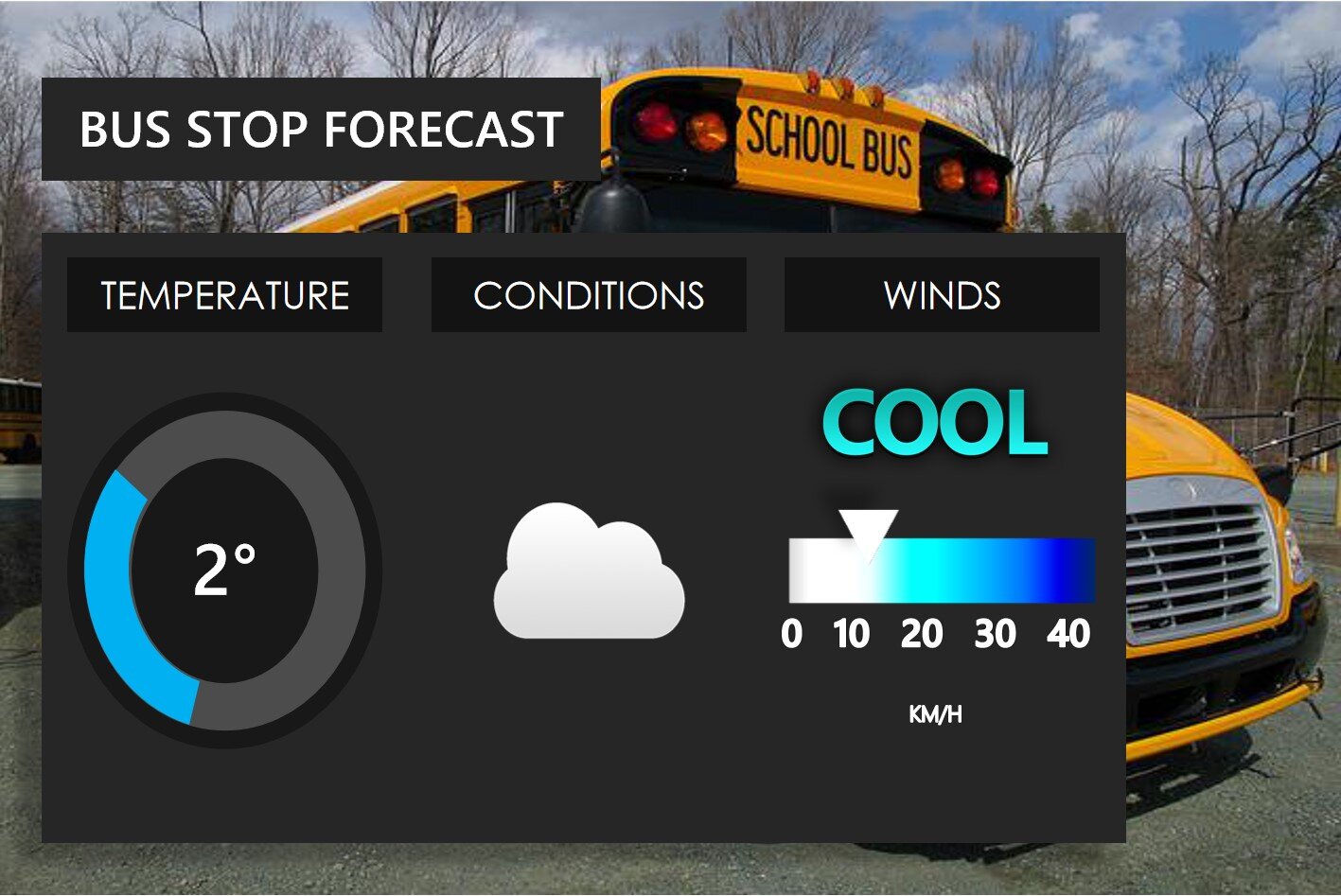
Out to the bus stop! looking at a much milder morning! compared to -10's yesterday morning. However more cloud cover! Temperatures around 2 degrees on the plus side as you head to the bus stop!
Coming up in the next half hour at 7am, we'll have the latest weather conditions and Traffic updates and at 8am, the latest on your detailed weather forecast!
7 AM! Time to look at the Traffic and latest weather conditions! We’ll start with traffic first! and we do have some snowy weather out there this morning along with the western parts of the province. Main areas of slow travel and snow-covered roads will be along with Cumberland County, Colchester & Hants county this morning.
So if you’re in those regions this morning, may want to give yourselves some extra time and reduce your speed this morning as you head off to school or work.


Elsewhere the roads are bare or wet! and dry conditions.


Taking a look at the road conditions now with the Nova Scotia webcams. We’ll start with the areas seeing the snow this morning.

Taking a look at Amherst HWY 104 N right now, no traffic but it’s not a pretty drive! mostly snow covered roads, and low visibility under some falling snow.

Springhill HWY 104 N, light traffic, some very heavy snow falling and roads are snow covered, so please use extra care on the roads this morning if in Springhill and surrounding areas!
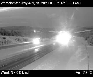
Westchester HWY 4 N now, light traffic and cloudy skies with some snow. wet and slushy road conditions so be sure to reduce your speed and take some extra time on the roads this morning.

Heading to Pugwash HWY 6 E we have snow falling, and wet and slushy roads but no traffic! If heading out this way, be sure to take extra care on the roads and give your self some extra time!
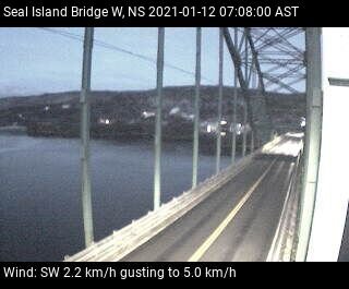
Looking at the Seal Island Bridge looking West, seeing no traffic, dry roads and dry conditions!

Looking at Seal Island Bridge looking East, no traffic, dry roads and dry conditions!

Bridgewater HWY 103 S now, little to no traffic, bare roads and dry conditions.

East Bay HWY 4 N, light traffic, bare roads, a bit slick and dry conditions.
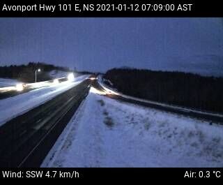
Avonport HWY 101 E looking at little to no traffic, slick roads and dry conditions

Pubnico HWY 103 E, looking at dry roads, dry conditions and little to no traffic!

Milford HWY 102 W we are looking at little traffic, dry conditions and bare roads.

Yarmouth HWY 101 N, light traffic and bare roads and dry conditions!

And lastly, looking at Meteghan HWY 101 N, little to no traffic, dry conditions and bare roads!
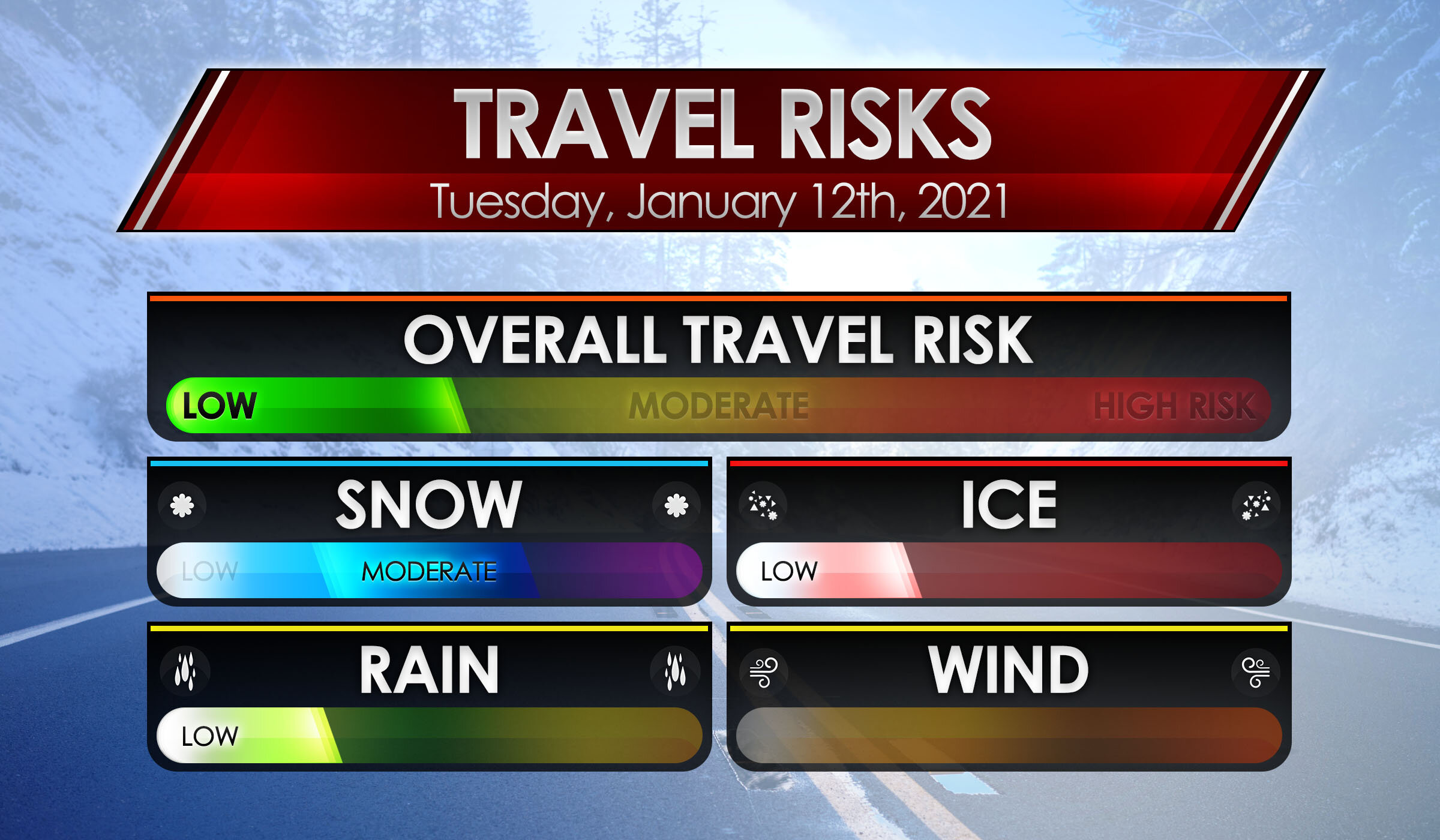
We have some travel risks to mention out there this morning with that snow in the western areas. Moderate travel risk for snow, Low travel risk for ice and rain. No wind issues! Overall the Travel risk is low, just be sure if heading on the 101 from Digby to Annapolis and then the 104 towards Amherst, you will need to slow down and take some extra time and care on the roads, this is where the weather Travel risks are needed. Elsewhere it’s dry and bare! and no Travel risk!

Heading for the airport this morning! Expect no delays! and all flights are on time!
The current local time is now 8 AM, when we come back at 9 AM we will have the full detailed weather forecast! And remember! to keep refreshing this page and keep checking it for live updates!