Fast-Moving System To Bring Southern Ontario’s First Widespread Snowfall of the Season Between Sunday and Monday

We’re now getting deep into November and it was only a matter of time before Mother Nature started to throw some wintery weather at Southern Ontario. And just that is in store for our region starting Sunday morning as an approaching weak system brings a mix of winter weather including rain and wet snow. For areas away from the lakeshore, we could be looking at several slushy centimetres of snow over the next 36 hours.

Now, this generally wouldn’t be considered a significant snowfall, but it will be quite wet and may make for some slippery driving conditions so you should drive according to the conditions. Less snow is expected through Extreme Southwestern Ontario, Niagara, GTA and in Eastern Ontario northeast of Lake Ontario. This is due to slightly warmer temperatures which will allow for more melting and some rain to mix in which would reduce overall accumulation.

This system is lacking in moisture which explains the lower snow totals across the region, however, a few pockets including to the northeast of Lake Erie east of London and through Central Ontario from Parry Sound into Algonquin Park may experience some lake enhancement. This could boost up the expected snow totals to near 10cm, but it’s not guaranteed especially in that Lake Erie zone which could be reduced by some rain mixing in.

The system will move out of the province by the mid-morning hours on Monday. We may see some lake effect snow develop off Georgian Bay and Lake Huron in the wake of the system later Monday although the exact intensity of this is unclear so it’s not included in the forecast.

Wintery Blast To Bring Northern Ontario’s First Significant Snowfall Between Wednesday and Friday With Up to 50cm of Accumulation Possible

A potential major snowstorm is on the horizon for parts of Northwestern Ontario over the next day as a strengthening low-pressure system stalls out and pumps moisture from the Gulf of Mexico into the region. This combined with a push of cold Arctic air will allow from rapidly accumulating snowfall starting late Wednesday, continuing through Thursday and lingering into Friday. The heavy snow will also be accompanied by some very strong wind gusts which will result in blowing snow and near whiteout conditions out on the roads.

Conditions will begin to deteriorate starting Wednesday evening as the first bands of snowfall enter the region from Manitoba and Minnesota and slowly spread to the north and east throughout the overnight hours. The worst conditions will be found during the day on Thursday when the snow will be at its heaviest in addition to the wind starting to pick up. Travel will likely be near impossible on Thursday through the Kenora, Dryden, Sioux Lookout and Armstrong area and we may even see some highways closures. This will continue overnight and into Friday will very rapid snowfall accumulation still occurring for much of the day on Friday too. We will finally see the system move out of the region by late Friday, but some snow may still continue especially near the Quebec border and around James Bay.

For accumulation, we’re looking at a maximum of around 30-50cm with locally in excess of 50cm. This zone includes the Kenora, Dryden, Sioux Lookout, Fort Frances and Armstrong areas. Other locations such as Atikokan, Geraldton and Fort Hope will see slightly lower amounts topping out at between 20-30cm. As for Thunder Bay, they’re right on the mixing line and may see some rain mix into the wet flurries which will help stop much accumulation from occurring. Right now we’re saying 5-10cm although this may change depending on the track of the system.

First Snowstorm of the Season Takes Aim at Saskatchewan and Manitoba With Up to 30cm of Snow Between Wednesday and Friday

A slow-moving system currently developing over Alberta is expected to bring a wintery blast of heavy snow beginning early Wednesday morning through Central Saskatchewan around Meadow Lake. This band of snow will slowly spread to the southeast towards the Yorkton region by late Wednesday morning and start to affect parts of Southern Manitoba during the day on Wednesday.

There was some uncertainty regarding precipitation type particularly through Southern Manitoba although the latest data appears to point towards a colder solution which would allow for more snow instead of rain mixing in and decreasing accumulation. As such, Winnipeg and most areas except for right along the International border will see predominately snow (likely in the form of heavy wet snow) with accumulation occurring later in the day as temperatures drop further below the freezing mark. Keep in mind that this event is still heavily temperature-dependent and a few degrees can make the difference between a few slushy centimetres and 20+cm of snow.

Snow will continue overnight into Thursday as the low-pressure system responsible for this snow stalls our and bands of precipitation wraps back in through Saskatchewan and Manitoba all day on Thursday. We will start to see some clearing later on Thursday for Saskatchewan with it lingering into early Friday for Southern Manitoba. All of the snow should be finished by Friday morning across the region except for some scattered flurries across Southwestern Manitoba.

As for accumulation, this is really tricky due to the issue with temperatures which can be hard to predict with melting. Although our target zone for the heaviest snowfall includes parts of Southeastern Saskatchewan around Yorkton and extending into Southern Manitoba around the higher elevations for Dauphin and the Interlakes region. This area can expect between 20-30cm of accumulation, but some models are pointing towards as much as 40-50cm of accumulation in localized areas mainly around Dauphin. The rest of Southern Manitoba including Winnipeg and Brandon extending through Central Saskatchewan will generally see between 10-20cm of accumulation over the next three days with most of the accumulation coming on Thursday.

Soaking Start To Fall Across Southern Ontario With Up to 75–125mm of Rainfall Accumulation by Thursday

The calendar might show the start of fall as of Wednesday afternoon, but it will seem like Mother Nature has mistaken it for the start of spring with expected significant rainfall across the region over the next few days. This rainfall event will get going late Tuesday evening as bands of heavy rainfall and embedded non-severe thunderstorms set up from Extreme Southwestern Ontario and into parts of Central Ontario. It will continue overnight and throughout the day on Wednesday encompassing almost the entire region.

The rainfall will come in waves on Wednesday with isolated heavier pockets where embedded thunderstorms could deliver locally heavier rainfall amounts. There might be a few hours of clearing during the afternoon on Wednesday particularly around the Golden Horseshoe, but it won’t last long as more rounds of heavy rainfall move into the region from south of the border. This round will linger past the evening and overnight for the second night of heavy rainfall with a focus on Central Ontario and the GTA.

We will also see some strong wind gusts developing along the Lake Huron and Georgian Bay shoreline during the evening on Wednesday and continuing overnight. Wind gusts of between 50-80km/h are possible especially in areas close to the shoreline, but they shouldn’t reach severe levels.

By early Thursday, we’ll finally see the light at the end of the tunnel as the flow of heavy rainfall slowly breaks apart in the west and shifts to the east. Central and Southwestern Ontario should see the rain taper off by the late morning or early afternoon. Rain will continue for Eastern Ontario through the day on Thursday and into the overnight hours but it will be less intense than what we saw the previous night. The system will fully exit Southern Ontario by Friday morning although it will be short-lived with more rainfall possible over the weekend.

In terms of accumulation, we expect the heaviest rainfall totals will be found in a zone extending from Windsor, through regions east of Lake Huron and into portions of Central Ontario including Muskoka and Algonquin Park. Totals here will generally range from 75-125mm with isolated pockets that see thunderstorm activity picking up over 125mm. The rest of Southern Ontario except for Northeastern and Eastern Ontario will see widespread amounts between 40-75mm with locally up to 100mm. Eastern Ontario should see around 25-50mm, but most of that rainfall will come on Thursday instead of the first two days.

It’s important to note that this rainfall won’t be coming all at once as it will be spread out over the next 72 hours. Flooding will still be a major concern with this event, but it won’t be anywhere close to the impacts if we saw the same amount of rain from a stationary thunderstorm in just a few hours. Most of the rainfall will come on Wednesday and into early Thursday morning except for Eastern Ontario which will mostly stay dry until late Wednesday and Thursday.

Drenching Rain for Southern Ontario Over the Weekend; Locally Up to 100mm of Rainfall Possible

Don’t forget your umbrella if you plan to be outside this weekend! Mother Nature is planning on turning on the taps across Southern Ontario as an active storm track sets up across the region and pumps significant amounts of moisture over the next few days. There will also be the potential for embedded thunderstorms within all this moisture which will only further increase the rainfall totals over the next 72 hours.

By the end of the weekend, we could be talking about triple-digit rainfall totals with the hardest-hit regions seeing between 50-100mm and perhaps locally up to 125-150mm. The focus for the highest totals will be on the Lake Huron shoreline through Central Ontario and into parts of Eastern Ontario near the Quebec border with lower amounts the more south/east or north/west you go.

If you aren’t a fan of the rain, the good news is that this won’t make a mess of the entire weekend and there will be short dry slots between the multiple rounds of rain over the next few days. The rain has already started across Southern Ontario with moderate to heavy rainfall throughout the day on Friday. This is expected to linger into the overnight hours before tapering off somewhat early Saturday morning, but scattered showers may linger around especially through Eastern Ontario.

Although the break will be short-lived as more moisture builds in from the west by Saturday afternoon. This wound could bring some quite intense and potentially near-severe thunderstorms during the evening hours on Saturday for regions east of Georgian Bay. At a minimum, these storms will pack a punch with very intense rainfall rates and some ‘training’ potential where the storms line up for hours over a particular location. Some stronger wind gusts and moderate-sized hail could also be associated with some of the more intense storms, but the exact severity remains unclear. This will be covered in a separate thunderstorm outlook for Saturday to be issued late Friday.

This heavy rain will continue throughout the overnight hours on Saturday and into Sunday morning with the bulk of the precipitation to the north of the GTA affecting Central and Eastern Ontario. It should move out of the province by Sunday mid-morning and allow for a fairly dry day on Sunday with the exception of some scattered showers and pop-up thunderstorms near Lake Huron towards the evening on Sunday. More rain will continue on and off for the early part of next week although we’re not expecting anything widespread or intense so we won’t be including it in this forecast.

The map above should give a rough idea of how much rain to expect over the next 3 days including what has already fallen on Friday. It’s important to note that at first glance the numbers on the map may appear quite extreme as we usually see severe flooding with just 50-75mm from a thunderstorm let alone 100+mm. The thing to remember that all this rainfall will be spread out over 72 hours rather than just a few hours that we see with the major flooding events in the past.

Regardless, we haven’t really seen a lot of rain over the past few months so this will be a significant amount of rain for the ground to absorb and flooding will be quite likely to an extent. Since thunderstorms will be embedded within the precipitation over the next few days it will result in highly variable rainfall totals even within a small area. For example, one location may see 50mm while another gets 150mm. That’s why our forecast ranges are quite large since this event is very tricky to narrow down the exact amount of rain a location will see.

Questionable Severe Thunderstorm Risk Through Eastern & Northeastern Ontario for Saturday Afternoon/Evening

Mother Nature has certainly cranked up the thermostat across Southern Ontario with a multi-day heatwave expected to continue into the early part of the week. Many areas will see daytime highs exceed 30°C including during the day on Saturday and for several days to come. This hotter weather is also a key ingredient in thunderstorms that could develop over the next few days bringing with it the threat of some severe weather.

The thunderstorm risk for Saturday is focused on parts of Southern Quebec and also extends into Northeastern and Eastern Ontario along the Quebec border. Any storms that develop in this area mainly during the late afternoon and early evening hours have the potential to quickly become severe with damaging wind gusts and large hail as the main threat. However, it’s not guaranteed and is dependent on storms actually developing which some models suggest the storms will stay over Quebec and not cross the border into Ontario. There is also a very low tornado threat, but it can’t be completely ruled out especially in this environment.

With the season’s first robust severe risk we thought it would be a good time to introduce our new regional thundercast timeline graphic that should help break down the risk by time instead of by location. Keep in mind this is still in testing and we’ll be tweaking it throughout the season - storms may happen outside of the timeline shown on the graphic, but it’s our best guess on when storms will develop based on the environment and future radar.

Today’s severe risk will likely occur during the late afternoon and early evening hours with a slightly earlier timeline through Northeastern Ontario compared to Eastern Ontario. The strongest threat will be found during the dinner hour between 5-10 PM depending on your location. Again, these storms could develop further to the north and stay over Quebec so it’s possible this whole event may ‘bust’.

As usual, we’ll be here keeping you updated on any active weather that may develop. Stay safe!

Very Isolated Risk for Marginally Severe Thunderstorms in Eastern Ontario and Parts of Northeastern Ontario (Tues, May 25, 2021)

We’re closely watching for the potential of very isolated, marginally severe thunderstorms this afternoon and evening in parts of eastern Ontario and northeastern Ontario. What do we mean by very isolated? Great question! We mean that the majority of those in the risk area will not even see a drop of rain. Having said that, for those who do see a storm, there is a low risk for damaging wind gusts, hail, frequent lightning, perhaps some isolated flooding, and a low risk for an isolated tornado.

Based on the latest model data, the risk is between 2PM and 9PM with a focus south of Ottawa, perhaps near the Smith Falls area around 3-6PM.

The storms should be moving in an east or southeasterly direction and again, the majority of those in the highlighted region won’t even see a drop of rain so don’t be disappointed if you’re missed. :)

Northeastern Ontario may also have some low tornado potential, especially further north than this map even covers. In case you’re in northern Ontario and wondering why we don’t cover your area, we have a Facebook & Twitter page dedicated to northern Ontario called “Instant Weather Northern Ontario”. Click the links below to join us there!

On Facebook, find us at Facebook.com/InstantWeatherNON and on Twitter you can find us at Twitter.com/IWeatherNON

Long story slightly longer, make sure you have our free app Instant Weather downloaded and if we see anything severe or anything with developing rotation, we’ll send out an update directly to your phone or tablet!

Blustery and Chilly End to the Week and Month With Wind Gusts Up to 95km/h and Risk of Flurries on Friday Across Parts of Southern Ontario

The weather in April this year has been all over the place from unseasonably warm temperatures well into the 20s on several days this month to a near-miss with a potential late-season snowstorm that still brought a blast of snow to parts of the province just over a week ago. The rollercoaster of weather continues as we say goodbye to April and hello to May with the return of colder temperatures along with strong wind gusts throughout the day on Friday. The colder temperatures could also result in the potential for a few flurries across Central and Eastern Ontario during the afternoon and evening on Friday although significant accumulation isn’t expected at this point. We’ll see early morning lows on Saturday several degrees below the freezing mark making for probably the chilliest morning in several weeks. Maybe hold off on putting away that winter coat!

The main story of Friday will be the brisk northwesterly winds that will pick up after sunrise on Friday that will also usher in the colder Arctic air from the north. These winds will be quite strong across Southern Ontario generally ranging from 60-80km/h in most areas with the strongest gusts occurring during the afternoon hours on Friday. There are a few pockets of even stronger gusts that we’re watching that could impact a zone to the north of the GTA around Lake Simcoe and along the eastern Lake Huron shoreline. These regions could experience gusts as high as 80-95km/h which could result in some damage and power outages. Be sure to bring in or secure any objects that could be blown away in the strong winds. The winds will remain quite strong as we head into the evening on Friday although we should being to see the subside past midnight into Saturday morning.

Precipitation associated with the system currently bringing some rainfall to Southern Ontario today will wrap back around on Friday as the colder air floods into the province. This will provide the potential for the rain to transitioning over to some wet flurries or even accumulating snow for more elevated and northern regions during the afternoon and evening on Friday. However, you likely won’t need to dig out the snow shovel for this event as most of the snow should melt on contact due to the wet ground from earlier snowfall and the ground will still be warm despite the below-freezing temperatures. The highest snow totals will be found through North Bay, Algonquin Park and more elevated parts of Central Ontario with the potential for up to 5cm of accumulation. Other areas can expect at most maybe a dusting of snow if anything at all. The snow will taper off late Friday as the system finally moves out of our region.

Most of Southern Ontario To Miss Out on Late Season Snowstorm for Wednesday; Niagara Region To Feel the Brunt With Up to 15cm of Snow

After a few days of bracing for what could be have been a historic snowstorm for this time of the year across Southern Ontario, it looks like we will see yet another near miss which has become the common occurrence this winter. Now, not all of Southern Ontario will escape the last blast of winter weather with a swath of heavy snowfall stretching from Extreme Southwestern Ontario along the Lake Erie shoreline, into Niagara Region and Eastern Ontario along the international border. If you were looking forward to the snow then you’d want to be in the eastern section of the Niagara Region including St. Catharines and Niagara Falls which could see around 15cm of accumulation on Wednesday.

The snow has already begun earlier than expected through Windsor and parts of Southwestern Ontario late this afternoon and it will continue through the evening. We will see even heavier bands of precipitation move into the province spreading to the northeast past the midnight hours and during the morning on Wednesday. The worst conditions will be found predawn Wednesday as the system hugs the international border as it tracks to the northeast. There is some uncertainty on the exact track and the cutoff between heavy snowfall to only a few flurries will be quite tight so just a few kilometres could be the difference between 1cm or 10+cm. The snow will taper off for most areas by the noon hour although it will linger into the afternoon for Eastern Ontario.

As we’ve said, the accumulation gradient will be very tight so there could still be some variance in the actual accumulation by Wednesday afternoon. Right now we’re looking at the Niagara Region being the ‘winner’ of the storm with around 10-15cm of accumulation possible. Other areas along the Lake Erie shoreline and into Eastern Ontario near the border can expect between 6-12cm (likely on the lower end of that range).

The Windsor and Hamilton area is on the cusp of the heavier accumulation so while we have them in the 6-12cm zone on the map, around 4-8cm is probably a better estimate in terms of what sticks to the ground once we account for the wetter snow and melting. Sarnia, London and the rest of the GTA will see a few centimetres of wet snow and maybe up to 5cm in the hardest-hit areas depending on the track. Wouldn’t be surprised to see this area underperform if the precipitation is even more contained to the border. All other parts of Southern Ontario will see just flurries with little to no accumulation expected.

If you don’t like the snow, you’ll be happy to hear that temperatures will rise well above the freezing mark later in the day on Wednesday so this should melt most of the snow that accumulated during the morning. And double-digit temperatures will make a return later by the end of the week! We don’t want to jinx it, but this will likely be our last major snowfall event of the season.

Close Call With Potential Late-Season Snowstorm for Parts of Southern Ontario; Up to 10–20cm of Accumulation With Northern Storm Track

At the beginning of the weekend, we noticed the potential for a late-season snowstorm for Southern Ontario sometime during the middle of this week which had a surprising amount of model agreement that far out. Earlier trends suggested a more northern track that would put the heaviest snowfall accumulation through Central and Northeastern Ontario. Over the last few days, we’ve continued to go over the latest data and there has been a noticeable southern shift in the expected track of this system.

This has caused the models to diverge in the potential scenarios with some models suggesting a track so far to the south that would mean much of Southern Ontario would miss the heaviest snow except for those close to the international border. On the other hand, some models have held with a more northern track which would bring the potential for widespread 12-20cm stretching from Windsor through London and into the GTA and Eastern Ontario. This would certainly be the biggest snowfall many have seen this late into the season in quite a long time if it happens.

Normally we would have a preliminary forecast out by now with the event less than 36 hours away, but the confidence in the track is so low that we don’t think it would be responsible for us to choose one scenario and put that out like it’s the expected outcome. Instead, we have decided to put together two different maps with one showing the more northern track (Scenario #1) and the other one showing the southern track (Scenario #2). We felt it was important enough to put something out given the potential significance of this event instead of waiting until the models started to converge on a track. We do expect some variance in the track and our final map will likely be a combination of both scenarios so keep in mind it’s not one or the other. These are technically the extremes of the two tracks and the actual outcome will probably be somewhere in the middle.

As for the timing of the snowfall, we expect the first bands of precipitation to reach areas around Lake Erie just after midnight Tuesday night with it continuing to spread to the northeast throughout the morning on Wednesday. For those the still need to travel for work, the morning commute on Wednesday will likely be heavily impacted due to the extensive snowfall rates during this timeframe. Please leave plenty of time to get to your destination. The majority of the snowfall will come down during the early part of Wednesday except for Eastern Ontario which will see it linger into the afternoon hours. All of the snow should come to an end by Wednesday evening.

As we’ve said, the total accumulation from this system will depend on the track with the northern track bringing the heaviest impacts to Southern Ontario. The southern track would still have an impact on our region bringing 6-12cm of snowfall accumulation from Windsor through the Niagara region and into Extreme Eastern Ontario. Refer to the two maps above for a rough idea of the potential accumulation for your location for each scenario.

We will be continuing to go over the latest data over the next day and will have our final forecast out sometime Tuesday. Check back for more!

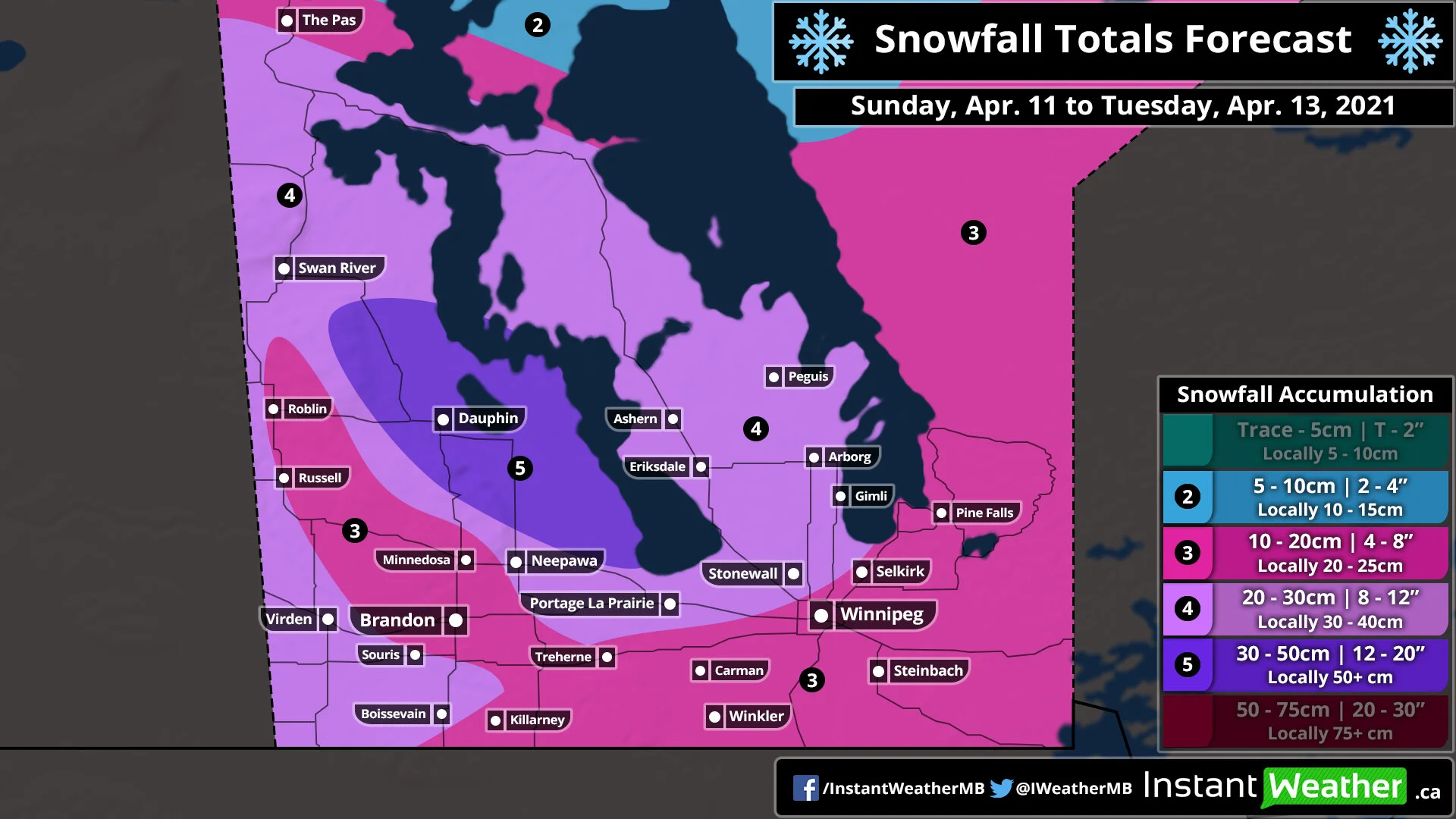
Winter Returns to Manitoba With a Multi-Day Snowstorm Starting Sunday Night; Widespread Snowfall Totals Between 15-30cm Across Southern Manitoba

After a rather mild start to the weekend across Manitoba with double-digit daytime highs on Saturday, there will be a rude awakening as we head towards the end of Sunday and into the beginning of the week. Temperatures are still in the upper single-digit or low teens this afternoon for much of Southern Manitoba although that is expected to change as colder air floods into the province. During the overnight hours, we will see temperatures continue to cool down reaching near the freezing mark in many areas or the lower single digits by Monday morning. The colder air will be accompanied by a stalled out low-pressure system that will linger and merge with another system over the next few days providing ample moisture for persistent moderate to heavy snowfall beginning Monday morning (it will start Sunday night for Southwestern Manitoba along the Saskatchewan border) and continue into Tuesday. Total accumulation over the 72 hour period could exceed the 30cm mark around the Dauphin area. Please pay attention to the fact that this snowfall will be spread out over the span of 2-3 days so it won’t have as big of an impact compared to if it all came down within a 24 hour period.

Current weather radar as of Sunday afternoon indicates that an area of precipitation is currently bringing heavy wet snow to parts of Western Manitoba including the Swan River area and those along the Saskatchewan border. This will continue overnight with the snowfall mostly contained in the extreme western part of the province. Although by sunrise, we’ll see another system from Northern Ontario enter into the eastern part of the province and begin the merge with the other system that was bringing heavy snow to Western Manitoba and parts of Saskatchewan.

The precipitation with this newly merged system will wrap back around into Manitoba throughout the day on Monday and into the overnight hours. This will bring widespread heavy snowfall to much of the southern portion of the province with the heaviest accumulation expected during the afternoon. By the evening, we’ll see the bulk of the moisture focused on the Interlake region giving areas further to the south like Winnipeg and Brandon a break. Another blast of heavier snowfall is expected during the morning hours of Tuesday and into the afternoon. Snowfall will finally come to an end as we head into the later afternoon and evening hours on Tuesday with only flurries lingering around past the midnight hour.

The total accumulation from this multi-day event could reach as high as 30-50cm in a zone that includes the Dauphin area as indicated in the latest data. This could change and it’s possible that the data is overdone due to temperatures being near the freezing mark. Most of Southwestern Manitoba and the Interlake region can expect general amounts between 20-30cm except for a pocket that includes Brandon, Minnedosa and Roblin who could see less precipitation and keep totals closer to 10-15cm. The rest of Southern Manitoba including Winnipeg and Southeastern Manitoba is currently on track for totals between 10-20cm, but again this could end up being lower due to temperatures near the freezing mark and the potential for some mixing.

Winter Returns to Saskatchewan With a Multi-Day Snowstorm Starting Sunday; Locally Up to 30-50cm of Snow in the Hardest-Hit Regions by Tuesday

After a rather mild start to the weekend across Saskatchewan with double-digit daytime highs on Saturday, there will be a rude awakening as we head throughout the day on Sunday and the beginning of the week. Temperatures have already cooled down substantially during the early part of Sunday and the temperatures are only expected to get colder later in the day. By Sunday evening, we’ll see much of South-central and southeastern Saskatchewan at the freezing mark or slightly below and dropping several degrees below the freezing mark after midnight. The colder air will be accompanied by a stalled out low-pressure system that will linger and merge with another system over the next few days providing ample moisture for persistent moderate to heavy snowfall beginning Sunday afternoon and continue through Monday and even into Tuesday. Total accumulation over the 72 hour period could exceed the 30cm mark in some areas within Southeastern Saskatchewan including Yorkton. Please pay attention to the fact that this snowfall will be spread out over the span of 3 days so it won’t have as big of an impact compared to if it all came down within a 24 hour period.

Current weather radar as of Sunday afternoon indicates that an area of precipitation has developed over Southeastern Saskatchewan and has begun to switch over from rain to wet snow as temperatures slowly cool down. Regina has likely already started to see the wet snow with the Yorkton area switching over in the coming hours. The first round of snow will be ongoing throughout the evening and overnight into early Monday morning focused on the Yorkton, Regina and Moosomin area. This band of snow will be quite narrow so the heaviest accumulation will be very localized and not everyone will see it. We will see the snow become more scattered and lighter after sunrise on Monday with expected accumulation on the ground as you wake up ranging from 15-25cm for the corridor between Regina and Yorkton and between 5-15cm for other areas including the City of Regina.

A second round of snow will enter the eastern part of the province as the previous system that brought us the snowfall tonight will merge with a secondary system over Northern Ontario. The precipitation with this newly merged system will wrap back around into Saskatchewan late Monday and continue overnight into Tuesday. This round won’t be as intense as the one tonight, but it will be more sustained and widespread lasting through much of the day on Tuesday. Snowfall will finally come to an end as we head into the evening hours on Tuesday with only flurries lingering around past the midnight hour. Expect an additional 10-20cm of snowfall accumulation throughout Southeastern Saskatchewan with locally 20-25cm in some areas closer to the Manitoba border.

The total accumulation from this multi-day event could reach as high as 30-50cm in a zone through parts of Southeastern Saskatchewan between Regina and Yorkton. Keep in mind that this is very temperature-dependent and with the ground still wet from the earlier rainfall, the snow may struggle to stick to the ground at first and resulting in lower snow totals. The rest of Southeastern Saskatchewan can expect general amounts between 15-30cm depending on your location. The further north and west you go, the less accumulation that is expected from this storm. Looking at around 10-20cm for the Moose Jaw and Swift Current area and between 5-10cm for Saskatoon.

Potential April Fools’ Snowstorm for Eastern Ontario; Up to 12–20cm of Snowfall Accumulation Possible

If you live in Eastern Ontario, you might’ve felt left out this winter as it seemed like every significant storm missed the region or ended up on the warm side of a system resulting in heavy rainfall (as we saw for Christmas). Not so fast! Mother Nature is brewing a cruel April Fools’ joke for those in Eastern Ontario that just want to be over with winter and get started with spring. A moisture-laden system is expected to track up the US Eastern Seaboard between Wednesday and Thursday bringing a swath of messy weather to New York and New England as it clashes with colder air flooding in from the north. The latest data indicates that the northwestern precipitation bands could stretch into Extreme Eastern Ontario with heavy snow starting early Thursday morning and continuing throughout the day.

However, this storm is highly track-dependent and the models so far have been shifting with almost every update so keep in mind this forecast could change drastically even with 2 days to go. We feel it’s significant and consistent enough to warrant a preliminary forecast to outline what may happen even if it ends up tracking more to the east and misses Southern Ontario entirely. Stay tuned for our final forecast to be posted by late Wednesday where we should have more confidence on the track of the system.

After a relatively warm day on Tuesday, we’re expecting slightly colder daytime temperatures for Wednesday mostly as a result of scattered rain showered moving across Southern Ontario throughout the morning and afternoon hours. This will usher in even colder air behind it as it moves out plunging temperatures to near or below the freezing mark as we head into Wednesday night. The colder air will play a key role in the potential for significant snowfall across Eastern Ontario as precipitation from a system over New England pushes into the far eastern part of our province. Heavy snow is expected to begin to affect locations such as Brockville, Morrisburg and Cornwall predawn Thursday and will likely have a major impact on the morning community in this area. Later in the morning, it will expand even further to the northeast including Ottawa and Kingston although there is some uncertainty on how widespread the heavy snowfall will be. This will continue through the morning and early afternoon before the snow tapers off to some scattered flurries by the late afternoon.

As far as potential accumulation, this again will depend on the exact track of the system so expect some change. With that being said, we could see an area of accumulation ranging from 12-20cm extending from Brockville and along the international border toward Cornwall. There is some overachieving potential here and we could see some localized totals approach 25cm. For areas further east including Ottawa, Perth and Kingston we’re looking at final totals between 6-12cm although they may see only a few centimetres if the storm is more contained to the border. Surrounding regions and even into the Niagara Region could see around 2-6cm from this system with just trace amounts for the rest of Southern Ontario.

We will continue to watch this and issue a more detailed forecast when we have higher confidence in the track of the system. Stay tuned!

Significant Wind Storm and Snowfall To Start Off the Week Across Manitoba; Gusts Over 90km/h Possible

It’s almost the end of March and we’re well into spring, but the weather across Manitoba tomorrow morning and throughout the day will make it feel more like winter. A strong system developing over the Alberta Rockies is expected to move into the province Monday morning and into the afternoon bringing with it the threat of very strong wind gusts in the south and widespread snowfall to the north.

We’ll see the strongest gust in Extreme Southwestern Manitoba including Brandon, Portage La Prairie, Roblin and Virden with the maximum wind gusts ranging from 90-105km/h. The rest of Southern Manitoba will see wind gusts close to over above damaging levels around 8-95km/h including Winnipeg, Swan River and Gimli. The strong gusts will develop during the afternoon on Monday and continue into the evening before weakening overnight Monday.

For Southern Manitoba, we’re not expecting much in terms of snowfall with maybe a few flurries accumulating to up to 2cm. The heavier snowfall will be focused further north through the Interlake region with between 6 - 12cm of snowfall accumulation expected for Swan River, Dauphin, Peguis. Even higher totals are expected further north for The Pas and Norway House where snowfall and winter storm warnings are in effect from Environment Canada calling for between 15-25cm of accumulation. Conditions will improve early Tuesday as the system moves out over Northern Ontario.

Significant Wind Storm and Accumulating Snowfall To Start Off the Week Across Saskatchewan; Gusts Over 100km/h With 6–12cm of Snowfall Accumulation Possible

It’s almost the end of March and we’re well into spring, but the weather across Saskatchewan tonight into Monday will make it feel more like winter. A strong system developing over the Alberta Rockies is expected to move into the province late Sunday evening and into the overnight hours bringing with it the threat of very strong wind gusts and widespread snowfall. The worst conditions will be found during the morning and afternoon on Monday with persistent light to moderate snowfall and wind gusts up to 100-115km/h in some areas.

We’ll see the strongest gust along the Alberta border including Swift Current, Shaunavon, Kindersley and Assiniboia with the maximum wind gusts ranging from 100-115km/h. The rest of Southern and Central Saskatchewan will see wind gusts approach damaging levels around 90-105km/h including Moose Jaw, Saskatoon and Regina with weaker winds to the north. The strong wind gusts will weaken as we head into the evening on Monday although they’ll likely continue to be quite strong up to midnight.

For much of Saskatchewan, we’re looking at between 6-12cm of snowfall accumulation between Monday and Tuesday. Some localized regions may pick up near 15-20cm although the data isn’t super strong so we’re holding with the 6-12cm zone as our maximum. There will be lower amounts along the international border with only a few centimetres expected. The snow will continue throughout Monday and slowly taper off overnight into early Tuesday morning.

Significant Wind Storm Takes Aim at Alberta Starting Sunday Evening and Continuing Into Monday; Wind Gusts in Excess of 100km/h Possible

Strong winds that have developed Sunday afternoon are only expected to get stronger later in the evening and overnight across Alberta. This is courtesy of a system that is also bringing widespread snowfall to the province early Monday morning and lasting through the day.

We expect the worst conditions will pre-dawn on Monday with maximum wind gusts across Southern Alberta approaching 100km/h or even exceeding that in some areas. Wind damage along with some power outages are likely. The wind will begin to die down as we head into the afternoon on Monday although it’ll still be quite gusty throughout the rest of the day.

As far as the snowfall is concerned, we’re not expecting significant accumulation and most areas will see maybe 5-10cm of snowfall accumulation. Higher amounts in the Rockies which is fairly typical with between 25-40cm expected as per Environment Canada. However, the strong winds could create blowing snow and hazardous driving conditions while the snow is coming down during the morning hours on Monday. Please drive with caution!

Conditions will improve late Monday as the system moves out over Saskatchewan and Manitoba.

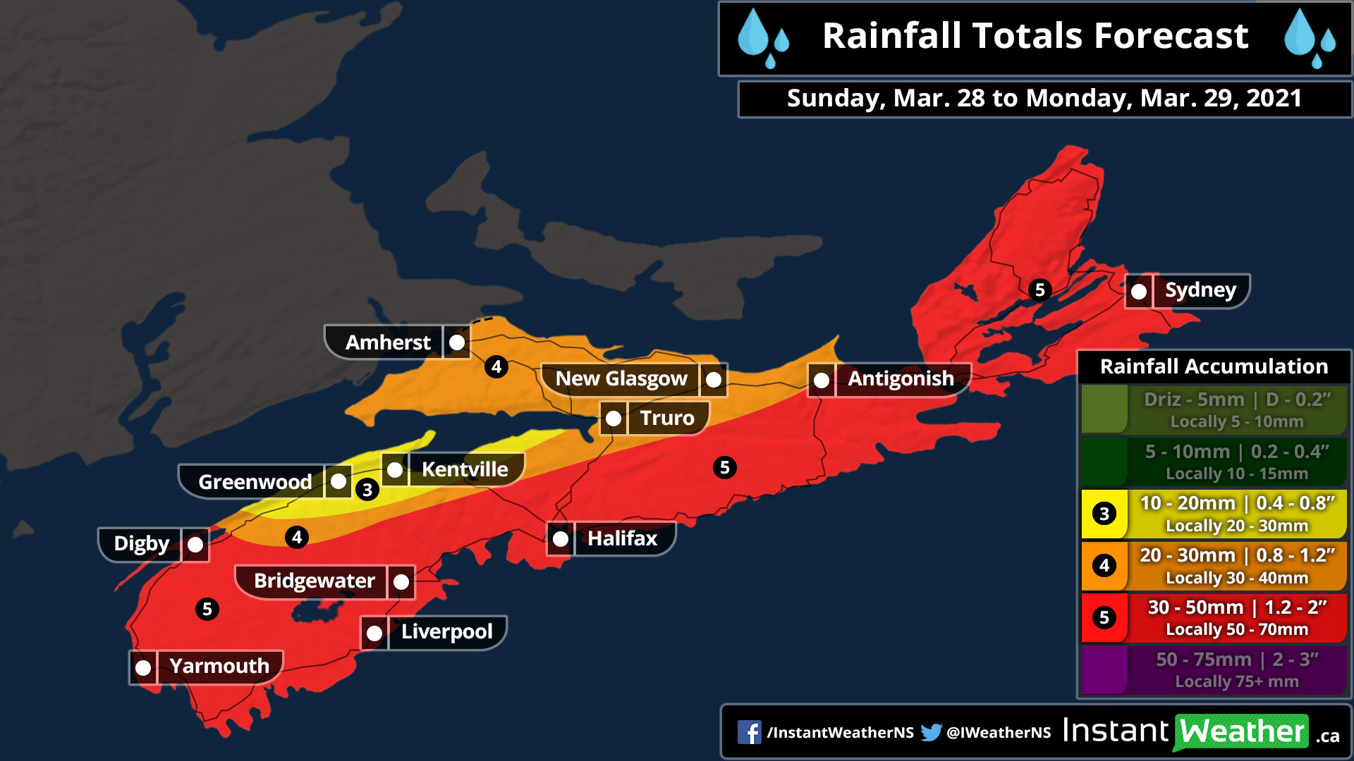
Strong Storm Takes Aim at Nova Scotia To Start Off the Week With Destructive Wind Gusts Over 100km/h and 30+mm of Rain Starting Sunday Evening

A very potent system is expected to move into Nova Scotia later Sunday bringing the threat of significant rainfall that may lead to some flooding and destructive wind gusts reaching up to 100-115km/h in the coastal parts of the province. The system is currently located over the Northeastern US and will move into the province sometime after the dinner hour starting with the extreme southern part of the province such as Yarmouth seeing the first effects and spreading northward through the province later in the evening.

Most of the rainfall that we’re expecting will come during the overnight hours and will be accompanied by damaging wind gusts which are expected to be the strongest during the early overnight. For Cape Breton, the temperature will be right near the freezing mark around midnight so we may see a few hours of wet snow or freezing rain before it switches over to rain as warmer air brings temperatures into the mid to upper single digits across Nova Scotia.

Rainfall will continue throughout the early part of Monday mainly during the morning hours. We’ll see it slowly taper off from west to east just after the noon hour. The strong winds are a similar story but will begin to weaken just after sunrise. All of the active weather should have exited the province by the late afternoon on Monday.

The strongest wind gusts from this storm will be found along the coast of Nova Scotia including Digby, Yarmouth, Halifax, Cape Breton and the northern part of the province near the New Brunswick border. This area could see maximum gusts between 100-115km/h particularly over the Greenwood/Kentville area which could see gust exceed 115km/h based on the latest data. We’ll see weaker wind gusts the further inland you get although all areas within the province should see gusts of at least 80km/h at some point during this storm. Significant wind damage is possible so be sure to secure anything that could be blown away and prepare for power outages across the province.

When it comes to the rainfall from this system, we’re looking at widespread totals between 20-40mm and maybe locally up to 50-60mm in some areas. The concern with this amount of rain is that it will come down within a short timeframe roughly around 12-16 hours so flooding could be a huge concerns in the hardest hit regions. The latest data suggests lower amounts for the north part of the province especially around the Greenwood/Kentville area which might struggle to even reach the 10mm mark from this storm.

We’ll continue to monitor this storm and keep you updated on any changes.

Messy End to the Beautiful Week Across Southern Ontario With Heavy Rain, Significant Freezing Rain and Strong Wind Gusts on Friday

Mother Nature has given us quite the treat the past week with extremely mild temperatures that we normally see towards the end of spring or even early summer. Although as we end of the week we’re looking at quite the messy system to affect Southern Ontario with mainly heavy rainfall and strong wind gusts on Friday. For areas further north through parts of Central Ontario and Northeastern Ontario, the main concern will be the potential for significant freezing rain along with some wet snow starting early Friday morning and continuing throughout the day. This will result in icy driving and even the threat of power outages in the hardest-hit regions.

Precipitation will begin to work into the province just before the midnight hour starting as rain along the Lake Erie shoreline. The heaviest rain is expected through Friday morning and afternoon and will start to become less intense later in the day. We will also see colder air flood into the province during the evening on Friday which may result in a few hours of wet snow in some areas although no accumulation is expected outside of Central and Northeastern Ontario since the ground will still be quite wet and warm. We expect total rainfall accumulation to range from 20-30mm in most areas although localized amounts in the heavier bands of precipitation may approach 40-50mm.

Precipitation will come to an end by late Friday as the system moves out over Quebec. It should also be noted that the rain will be accompanied by strong to damaging wind gusts approaching 70-80km/h in much of Southern Ontario. Wind gusts over 90km/h are possible for the northeastern shoreline of Lake Ontario and Erie including the Niagara Region and Prince Edward County. A separate wind map will be issued tonight for Friday morning.

There will also be a wintery component to this system although that will be focused on far northern sections of Central Ontario extending into parts of Northeastern Ontario. A heavy band of freezing rain will develop early Friday morning stretching from the Bruce Peninsula through areas north of Muskoka and into Algonquin Park. The hardest-hit regions could see around 6-12mm of ice accretion although the limited timeframe of this event should keep overall impacts from being too significant. Surrounding regions including Parry Sound and North Bay could see a few hours of freezing rain although it will likely be more of a messy mix including snow, ice pellets and regular rain depending on the temperature. Later in the day, we expect a switch over to heavy wet snow particularly for the North Bay/Powassan area where it’s more elevated. Some data suggests accumulation of over 15cm although we believe this is overdone and much of it will likely come down as ice pellets or melt on contact. Still expecting around 6-12cm of accumulation in the hardest-hit regions, but again the exact amount is unclear and is highly dependent on precipitation type and temperature.

In the wake of this system, we expect temperatures will be much colder than we’ve seen the past week. Overnight temperatures on Friday could drop below the freezing mark in many areas through Southern Ontario. Daytime highs throughout the weekend won’t be super chilly staying within the mid to upper single digits although it’s unlikely we’ll see many double-digit highs (maybe for Extreme Southwestern Ontario).

Widespread Wind Storm Likely and Marginal (Low) Risk For Severe Thunderstorms Today

It will also be an active day weather-wise across Southern Ontario as a system moves into the region. Scattered rain showers will be ongoing throughout the day although it won’t be constant and actual rainfall totals will be below 10mm for most areas. Something we’re also watching is the risk of our first thunderstorm of the year which could bring heavy rain, a few lightning strikes, strong wind gusts and small hail. We're actually also seeing a low and somewhat questionable risk for brief, isolated tornadoes.

Considering we had 42 confirmed tornadoes in 2020 in Ontario, this shouldn't come as a big shock to anyone, even this early in the season. However, a few particular models have been consistent on the potential and we feel it's worth mentioning, especially with these substantial wind gusts we'll be experience while these storms are occurring. We’re working hard on a thunderstorm map and we’ll get that out ASAP.

Strong to damaging wind gusts will be a big concern throughout the province with gusts ranging from 80-95km/h in most areas. A few spots could stay under 80km/h but it will still be a very gusty day. A zone including parts of Grey-Bruce counties and into the Dundalk Highlands may see gusts approach 100km/h mainly along the Georgian Bay and Lake Huron shoreline.

All good things must come to an end though as colder air is expected to return late Thursday into Friday. This will drop temperatures back to below the freezing mark setting the stage for a pretty chilly weekend. Morning low on Saturday could come near -10°C in some areas!

We’re only a few days into the start of meteorological spring and Mother Nature is wasting no time with leaving the winter we had (which wasn’t much) and pushing Southern Ontario right into spring-like weather this week. This will especially be true for Thursday as we’re expecting the warmest air of the year to invade the region bringing temperatures into the upper teens and perhaps even near 20°C. Although before you get too excited for a chance to go out and enjoy these temperatures, the warmer temperatures will be accompanied by some rain (maybe even the chance of a thunderstorm) along with strong wind gusts between 80-95km/h. There should be a few hours without rain in some areas so you should hopefully still be able to get out there but don’t plan on a whole day of beautiful weather.

Many regions across Southern Ontario are already basking in some warm air on Wednesday with the temperature reaching into the low to mid-double digits. Temperatures will cool down somewhat overnight as is usual once the sun goes down and daylight heating into factored in, but the mild temperatures will return Thursday afternoon likely a few degrees higher than Wednesday. Widespread daytime highs throughout Southern Ontario will range from around 15-20°C and even some areas around the Golden Horseshoe and into Extreme Southwestern Ontario could come near 20 °C.

Areas further to the north including Central and Northeastern Ontario will see temperatures in the upper single-digit to the low double digits. It should be noted that there is some disagreement in the models exactly how warm it will be with some suggesting similar temperatures as we saw on Wednesday. So far this week, actual temperatures have been higher than what most models indicated so we believe that will continue. If we see more rain on Thursday it could keep the temperature down into the low teens instead of the upper teens.