Ice Day (Bus Cancellation) Outlook for Wednesday, November 17, 2021

There is the risk of freezing rain starting Wednesday morning and continuing through the early afternoon hours in areas along the Quebec border. This has prompted Environment Canada to issue some freezing rain warnings which could cause some school bus cancellations within the affected areas on Wednesday.

We believe the North Bay area has the highest probability of getting an ‘ice day’ with a 75% chance. The Petawawa and Barry’s Bay area also has a decent probability of around 50%, but keep in mind that this school board cancels buses by region so those in Renfrew county will likely be unaffected. The surrounding region through the Ottawa Valley and into northern parts of Central Ontario varies from a 5-25% chance. In this area, bus cancellations are unlikely, but not entirely out of the question due to some freezing drizzle in the morning.

If there are any cancellations tomorrow morning, you can be sure we’ll be up bright and early beginning at 6 AM with our bus cancellations live blog to keep you updated.


Disclaimer: Instant Weather has zero authority when it comes to bus and school closures. It is completely up to the school boards, bus companies, and local authorities as well as being up to parents to decide what is best for their children. This is simply our best guess based on our forecast. Also note that due to the current pandemic, some school boards have changed their policies on school bus cancellations. Some will continue the school day in a virtual format should there be school bus cancellations - check with your local board for more details.

Northern Ontario: Fall Weather Hazards Outlook for Wednesday, November 17, 2021

Forecast Discussion

A system that has been bringing heavy snow to parts of Northwestern Ontario will start to move into Northeastern Ontario where there is the risk of freezing rain. This will begin early Wednesday morning with the heaviest ice accretion found along the Quebec border from North Bay to Cochrane. They may pick up to 6mm of ice accretion. The freezing rain could make for some slippery driving conditions for the Wednesday morning commute in the area. Be sure to drive with caution. Some isolated power outages can’t be ruled out, but it’s unlikely given the limited ice accretion expected. Conditions will improve by late Wednesday as warmer air flows into the region. Snow will also continue for other parts of Northern Ontario, please see our special outlook for more details here.

Southern Ontario: Fall Weather Hazards Outlook for Wednesday, November 17, 2021

Forecast Discussion

Precipitation associated with a system expected to bring significant snowfall accumulation will push through the northern section of Southern Ontario early Wednesday and continue into the afternoon. For the higher elevations along the Quebec border including North Bay, Algonquin Park and Petawawa, we could be looking at several hours of freezing rain mainly during the morning hours and transitioning over to regular rain later in the day as temperatures slowly rise above the freezing mark. Up to 6mm of ice accretion is possible within this zone.

In other areas including the Ottawa Valley, Bancroft, Sundridge and Sudbury there is the risk for some freezing drizzle before the switch over to rain happens although impacts will be minimal. This freezing rain could make for some slippery driving conditions for the Wednesday morning commute in the area. Be sure to drive with caution. Some isolated power outages can’t be ruled out, but it’s unlikely given the limited ice accretion expected. Conditions will improve by late Wednesday as warmer air flows into the region.

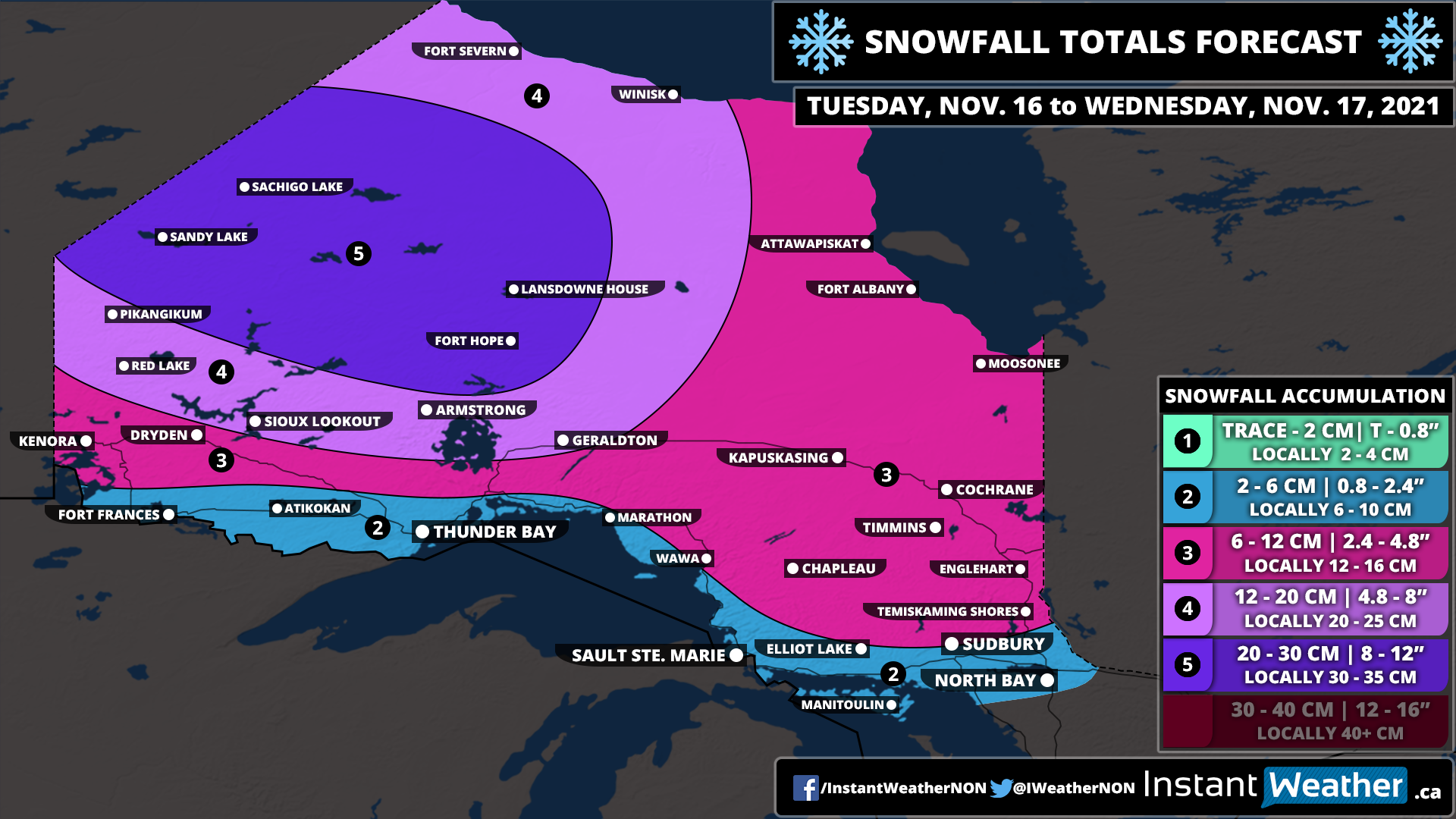
Midweek Snowstorm To Bring Up to 30cm of Snow to Parts of Northwestern Ontario Between Tuesday and Wednesday

The low-pressure system currently bringing record-breaking flooding to parts of British Columbia will race across the Prairies and start to affect Northwestern Ontario starting Tuesday morning with the initial bands of precipitation. Instead of rain, we are mainly looking at snowfall which could come down quite heavy at times. The system will be a lot weaker than when it made landfall in BC so this won’t be any more than a fairly typical snowstorm for the region.

We will see the worst conditions from this storm through Sandy Lake and Sachigo Lake during the later part of Tuesday and into Wednesday morning. Heavy snow combined with strong wind gusts up to 50-70km/h could create very poor travel conditions. Snow will continue during the day on Wednesday, but it won’t be as intense with the heavier precipitation being found along the Quebec border. There could be the risk of some freezing rain just north of Sudbury during the morning on Wednesday although confidence in that is low. The system will finally exist in the region by the end of Wednesday, but a few flurries may linger into Thursday.

We’re looking at around 20-30cm of snowfall accumulation through the hardest hit zone including Sandy Lake, Sachigo Lake, Fort Hope and Lansdowne House. A few localized areas could pick up more than 30cm. Other parts of Northwestern Ontario can expect around 12-20cm with between 6-12cm for the rest of Northern Ontario away from the shoreline of Lake Superior and Georgian Bay. We will likely see some rain along the shorelines which will reduce potential accumulation.

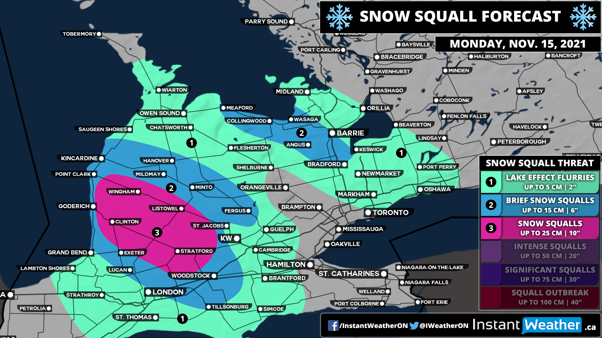
Snow Squalls Brings Snowy Blast to Parts of the Snowbelt Around Lake Huron and Georgian Bay on Monday With Locally Up to 15–25cm Possible

The start of the week through parts of the traditional snowbelt southeast of Lake Huron and Georgian Bay will get off on a snowy note as some organized lake effect snow and localized squalls are expected to develop early Monday. Current indications suggest that a fairly strong squall could develop off Lake Huron during the mid to late morning hours on Monday stretching from Goderich and further inland towards Stratford.

In addition to this, we will see some lake effect activity off Georgian Bay during the late morning affecting the Collingwood and Wasaga area along with the Hwy 400 corridor between Barrie and Bradford. This will continue throughout the day and may even linger into the overnight hours into predawn Tuesday. However, it should dissipate by mid-Tuesday morning so it shouldn’t have a significant impact on the morning commute.

As is typical with lake effect snow events, predicting the exact accumulation is very tricky as it depends on how strong the bands are and where exactly they lock-in. We do believe there is the potential that someone just to the southeast of Goderich including Clinton, Wingham, Listowel and Stratford could pick locally up to 20-25cm, but general snowfall amounts around 10-20cm are more likely. Surrounding regions including the Lake Huron shoreline where temperatures will be slightly warmer can expect between 5-10cm with locally up to 15cm. The Collingwood and Angus corridor could see around 10-15cm in the hardest-hit locations. The City of Barrie should escape the worst although the south end of the city could pick up near 10cm with around 5cm in the north end.

Travel conditions throughout the day on Monday will likely be very poor within the affected regions so be sure to take your time and maybe avoid travelling until conditions improve. Snow squalls can cause rapid reductions in visibility and make it hard to adjust to conditions.

Fast-Moving System To Bring Southern Ontario’s First Widespread Snowfall of the Season Between Sunday and Monday

We’re now getting deep into November and it was only a matter of time before Mother Nature started to throw some wintery weather at Southern Ontario. And just that is in store for our region starting Sunday morning as an approaching weak system brings a mix of winter weather including rain and wet snow. For areas away from the lakeshore, we could be looking at several slushy centimetres of snow over the next 36 hours.

Now, this generally wouldn’t be considered a significant snowfall, but it will be quite wet and may make for some slippery driving conditions so you should drive according to the conditions. Less snow is expected through Extreme Southwestern Ontario, Niagara, GTA and in Eastern Ontario northeast of Lake Ontario. This is due to slightly warmer temperatures which will allow for more melting and some rain to mix in which would reduce overall accumulation.

This system is lacking in moisture which explains the lower snow totals across the region, however, a few pockets including to the northeast of Lake Erie east of London and through Central Ontario from Parry Sound into Algonquin Park may experience some lake enhancement. This could boost up the expected snow totals to near 10cm, but it’s not guaranteed especially in that Lake Erie zone which could be reduced by some rain mixing in.

The system will move out of the province by the mid-morning hours on Monday. We may see some lake effect snow develop off Georgian Bay and Lake Huron in the wake of the system later Monday although the exact intensity of this is unclear so it’s not included in the forecast.

Southern Ontario: Fall Weather Hazards Outlook for Sunday, November 14, 2021

Forecast Discussion

A messy system is expected to affect Southern Ontario throughout Sunday and into Monday. This could bring accumulating snow to some parts of the region. Although there is some uncertainty on the exact temperature which would have a huge impact on the potential accumulation. More details in a special forecast to be issued on Saturday.

Southern Ontario: Fall Weather Hazards Outlook for Saturday, November 13, 2021

Forecast Discussion

After a brief period of mild weather across Southern Ontario the past week that brought double-digit temperatures, winter will make its return this weekend. This will begin with some lake effect flurries around Lake Huron and Georgian Bay along with northeast of Lake Erie into the Niagara region. The flurries will begin early Saturday morning and continue throughout the day. More snow is expected late Sunday into Monday as a system brings what could be the season’s first widespread snowfall for Southern Ontario. Accumulation on Saturday is expected to be fairly minor with most areas just seeing a dusting of snow if anything at all. A few locations may pick up close to 5cm or locally more should a strong snow streamer gets organized enough. Due to the nature of lake effect snow, you should be prepared for a rapid reduction in visibility so be sure to drive according to the conditions.