
Southern Ontario: Snowfall Outlook for Thursday, December 16, 2021
/Forecast Discussion
No heavy snowfall (2+cm) is expected in the forecast region on this day.

No heavy snowfall (2+cm) is expected in the forecast region on this day.

We’re tracking the potential for a destructive wind storm throughout much of Northern Ontario. The impacts of this second wind storm will vary depending on location, but it appears the damaging wind gusts will be strongest along the Lake Superior shoreline and into Northeastern Ontario. We’re quite concerned about the wind damage and power outage potential based on the latest data which has further increased the strength of the expected wind gusts.
The latest data shows widespread wind gusts exceeding 90km/h throughout Northeastern Ontario. We could see guests exceed 100km/h in locations including Thunder Bay, Marathon, Wawa and Sault Ste. Marie during the morning hours. The southern portion of Northeastern Ontario will see gusts ranging from 90-105km/h with less of an impact the further northwest you go in the region. Northwestern Ontario isn’t expecting much in terms of wind gusts from this system. However, Northwestern Ontario will see some heavy rainfall with between 20-40mm possible by the end of Thursday in locations such as Atikokan, Sioux Lookout and Armstrong.
We will see the wind begin to pick up during the early morning hours of Thursday for Southwestern Ontario as the deepening low-pressure system that spawned a line of destructive storms across the US Midwest moves into Northern Ontario. The wind gusts will continue to get even stronger later in the morning with the worst conditions expected during the mid to late morning. We should see the wind gusts slowly die down by afternoon however they will remain quite strong through the afternoon ranging from 60-80km/h.
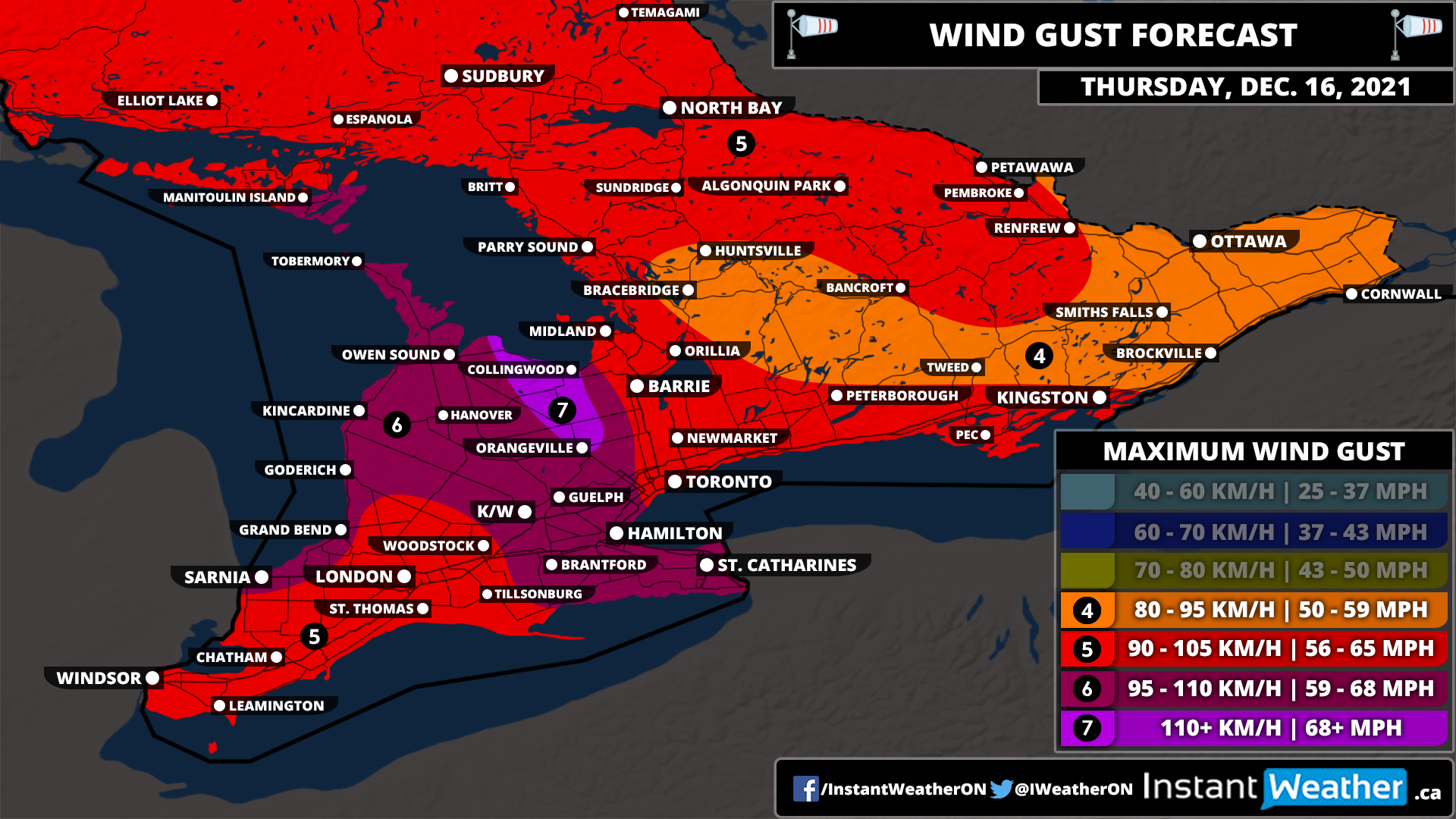
This has certainly been a weird start to winter across Southern Ontario as instead of snow and wintery weather, we’re tracking the potential for the second destructive wind storm in a week throughout much of Southern Ontario. The impacts of this second wind storm will vary depending on location, but it appears the damaging wind gusts will be way more widespread than Saturday and also affect parts of Central, Eastern and Northern Ontario which didn’t see the full brunt of the wind on Saturday. We’re quite concerned about the wind damage and power outage potential based on the latest data which has further increased the strength of the expected wind gusts.
The latest data shows widespread wind gusts exceeding 90km/h even further inland away from the shorelines. We could see gusts exceed 100km/h through the higher elevations northwest of the GTA, along Lake Huron and into the Hamilton and Niagara region. The Blue Mountains, Collingwood and Orangeville are consistently being highlighted in the data as seeing gusts potential exceed 110km/h. Wind gusts will be weakest through portions of Central and Eastern Ontario, but they’ll still see quite strong wind gusts ranging from 80-95km/h.
We will see the wind begin to pick up during the early morning hours of Thursday for Southwestern Ontario as the deepening low-pressure system that spawned a line of destructive storms across the US Midwest moves into Northern Ontario. The wind gusts will continue to get even stronger later in the morning with the worst conditions expected after sunrise on Thursday. For Eastern Ontario, the stronger gusts will occur during the late morning and early afternoon. We should see the wind gusts slowly die down later in the day however they will remain quite strong going into the evening ranging from 60-80km/h
Aside from the wind, we are looking at another unseasonably warm day with temperatures reaching into the low double digits. It’s possible some areas may break their temperature record. There is also a slight risk of some non-severe thunderstorms later on Thursday as a cold front sweeps across Southern Ontario. This will usher in some colder air bringing temperatures back to near or below the freezing mark overnight Thursday.

In Northern Ontario, the impact of the wind storm will be mostly focused on the Lake Superior shoreline and into Northeastern Ontario. Locations including Thunder Bay, Marathon, Wawa and Sault Ste. Marie may see gusts approach 100km/h during the morning hours. The southern portion of Northeastern Ontario will see gusts ranging from 90-105km/h with less of an impact the further northwest you go in the region. Northwestern Ontario isn’t expecting much in terms of wind gusts from this system. However, Northwestern Ontario will see some heavy rainfall with between 20-40mm possible by the end of Thursday in locations such as Atikokan, Sioux Lookout and Armstrong.

Strong to damaging wind gusts are expected to develop across parts of Northern Ontario on Thursday. However, the exact intensity of these gusts is currently unclear. Power outages and tree damage are possible. A full forecast will be issued on Wednesday once we have more data. In addition to this, heavy rainfall in excess of 25mm is possible in Northwestern Ontario.

Strong to damaging wind gusts are expected to develop across Southern Ontario on Thursday. However, the exact intensity of these gusts is currently unclear. Power outages and tree damage are possible. A full forecast will be issued on Wednesday once we have more data.

Inclement weather isn’t currently expected in the forecasted region on this day.

No heavy snowfall (10+cm) is expected in the forecast region on this day.

Light to moderate precipitation will move across Southern Ontario throughout the day on Wednesday with most areas seeing around 5-10mm of rainfall. However, there is an area along the Quebec border including the Ottawa Valley and into higher elevations of Central Ontario that could see a few hours of freezing rain. This will occur around the noon hour and continue through the afternoon as we see temperatures slowly rise. The rise in temperatures will eventually lead to a switch over to regular rain towards the late afternoon and early evening.
There is some uncertainty in regards to how fast the switch over will occur which would determine the exact impacts. Right now, we’re expecting between 1-3mm of ice accretion with locally up to 4-6mm, but it should melt away quite quickly after the warm-up. Some icy road conditions are possible during the afternoon so travel with caution through the affected regions.
No heavy snowfall (2+cm) is expected in the forecast region on this day.

There is the risk of freezing rain through parts of Eastern and Central Ontario starting early Wednesday afternoon. This has prompted Environment Canada to issue a Special Weather Statemate and will likely be upgraded to a Freezing Rain Warning by morning. As a result, we will likely see some bus cancellations in the morning in advance of the expected freezing rain. The best chance of an ‘ice day’ will exist through parts of North Bay and into Petawawa/Renfrew where the school boards tend to be more sensitive when it comes to weather alerts from Environment Canada. So we’ve given them a 75% chance of seeing bus cancellations.
As this event will occur in the afternoon, it will depend on school boards being proactive with the cancellations in the morning. So our forecast might not make much sense since Ottawa will see similar impacts as North Bay. However, we’ve factored in the history of each region into our forecast as it will be a subjective decision. We also considered the proportion of the region that is expected to see freezing rain as cancellations are often made at a county level. So for example, we have a 25% chance for the entire region of Muskoka as cancellations are generally made for the entire region even though only Huntsville is expecting any freezing rain. With this forecast, we’re more predicting human behaviour rather than weather conditions which is quite difficult to do. Keep in mind that confidence in this forecast is low - it’s possible we don’t see any cancellations on Wednesday.
If there are any cancellations tomorrow morning, you can be sure we’ll be up bright and early beginning at 6 AM with our bus cancellations live blog to keep you updated.
Disclaimer: Instant Weather has zero authority when it comes to bus and school closures. It is completely up to the school boards, bus companies, and local authorities as well as being up to parents to decide what is best for their children. This is simply our best guess based on our forecast. Also note that due to the current pandemic, some school boards have changed their policies on school bus cancellations. Some will continue the school day in a virtual format should there be school bus cancellations - check with your local board for more details.
Inclement weather isn’t currently expected in the forecasted region on this day.
No heavy snowfall (10+cm) is expected in the forecast region on this day.

Inclement weather isn’t currently expected in the forecasted region on this day.
No heavy snowfall (2+cm) is expected in the forecast region on this day.
Inclement weather isn’t currently expected in the forecasted region on this day.
No heavy snowfall (10+cm) is expected in the forecast region on this day.
Inclement weather isn’t currently expected in the forecasted region on this day.
No heavy snowfall (2+cm) is expected in the forecast region on this day.
Inclement weather isn’t currently expected in the forecasted region on this day.
No heavy snowfall (10+cm) is expected in the forecast region on this day.
