UPDATE: Monday’s Snowstorm Shifts Further West Bringing the Threat of 20+cm of Snow Into the GTA and Central Ontario; Up to 50cm of Snow Possible for Niagara and Eastern Ontario
/
It’s becoming increasingly likely that Southern Ontario will be hit with one of the strongest snowstorms that we’ve seen in quite a long time starting Sunday night and lasting into Monday. We’re starting to get a clearer picture on the exact track of this system and it’s probably the worst-case scenario in terms of impact on big population centres including the GTHA, Kingston and Ottawa.
Recently, the track of the system in model runs has consistently held further to the west even though these systems tend to track eastward at the last minute. To account for this possible eastern trend, we kept the higher snowfall totals further east in previous forecasts. However, it’s clear that is very unlikely to happen this close to the event and not much deviation in the current track is expected.
The biggest change we’ve made to our forecast is shifting the expected accumulation further to the west. This means that the Hamilton, Toronto and Durham area is now within our heaviest snowfall total zone with the expected accumulation ranging from 20-40cm.
You might notice that we’ve changed the top accumulation from 25-40cm to 20-40cm. This doesn’t mean that we’re expecting this storm to be any weaker and in fact, it could be stronger than expected and we might even see some thundersnow! The only reason we did this was so we can include the GTA into the higher totals which still accounts for the potential that the heaviest snow bands just remain to the east and they top out around 20-25cm. It’s still fairly unlikely as more models show totals over 30cm for the GTA than models that show less than 25cm.
In addition to this, there is growing confidence that parts of Eastern Ontario along with the Niagara region could approach 50cm of accumulation in localized areas. We have also expanded this zone further west to include Peterborough and eastern sections of Hamilton as models indicate this area could exceed 40cm as well. It still appears that Kingston and the Ottawa region will come out of this event with the most snowfall ranging from 40-50cm, but depending on the track it could shift slightly to the west.
The westward shift in our forecast will also affect the London, K/W, Barrie and Muskoka corridor where we’ve boosted their expected totals. It now looks like that accumulation ranging from 10-25cm is possible for those regions with lower totals the further west you go. Barrie/Orillia and Guelph will likely see close to 20cm with K/W and Muskoka picking up around 10-15cm. London will likely see around 6-12cm although the potential is there for up to 15cm if it tracks even further west.
As shown on our latest map, there is still some uncertainty in that area to the west of the GTA due to the extremely tight snowfall gradient. We’re starting to get more confident in the exact snowfall totals and as such has tightened the ‘uncertain’ zone and shifted it further west. However, a slight shift in the track could mean the difference between 5 and 15cm so don’t be surprised if this storm under or over performs the forecast in your area if you fall within this zone. The more confidence is in the GTA and Eastern Ontario where a minor shift in the track won’t make much of a difference.
Suggested Article

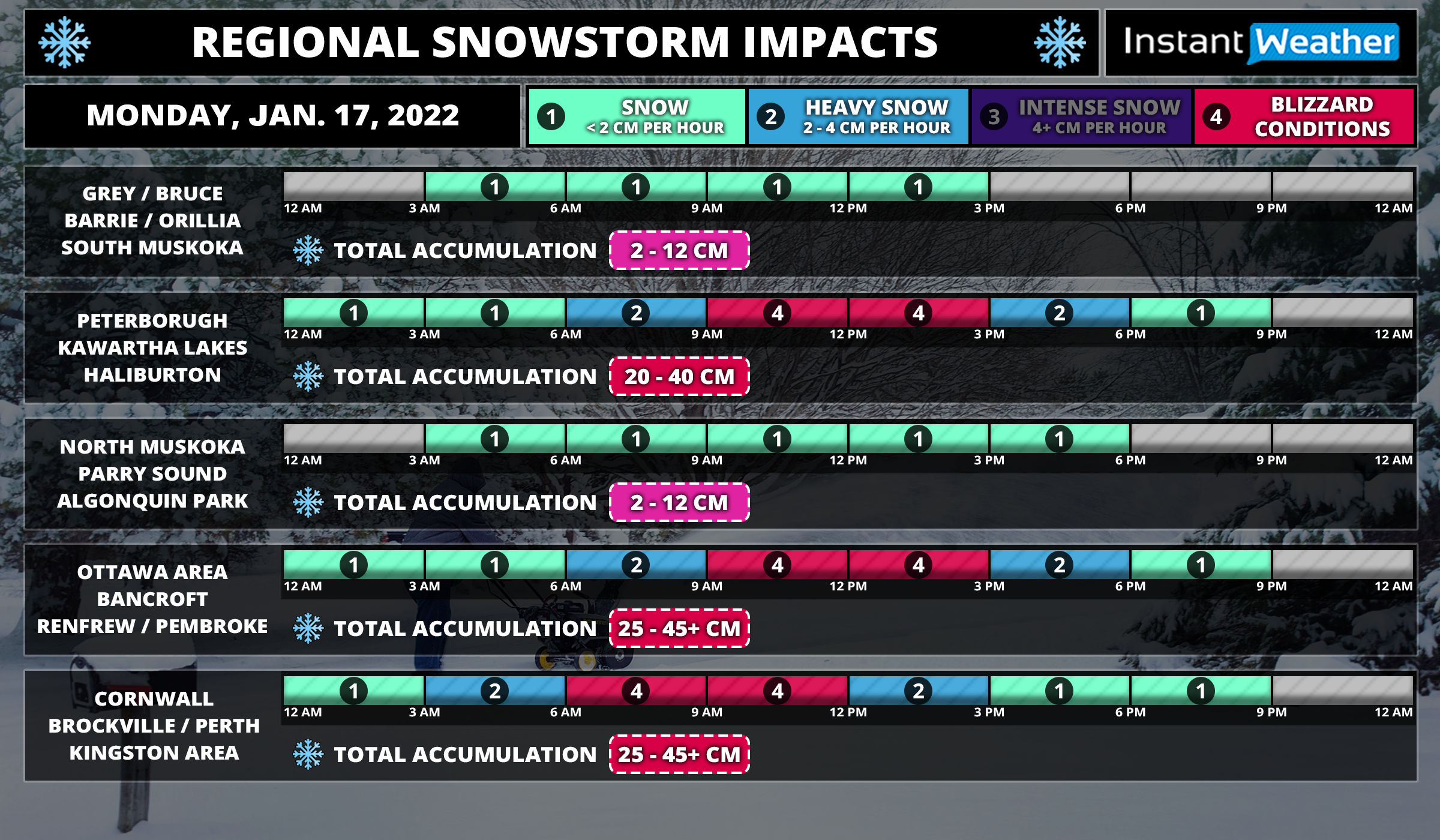
Regional Timing

TIP: You can click on either timeline graphic to open a zoomable version of the graphic.

The first bands of precipitation from this system will begin to affect areas around Lake Erie late Sunday evening close to the midnight hour including the Niagara Region and GTHA. The snow will be quite light for the first few hours, but don’t let that fool you! It will quickly pick up in intensity later in the overnight hour as the centre of the low tracks up the US East Coast. The heaviest snowfall will occur during the mid to late morning hours on Monday which is probably the worse timing for the morning commute. This is when there is the risk for blizzard-like conditions and blowing snow as the winds pick up around sunrise on Monday.
Eastern Ontario and parts of Central Ontario will see snow starting overnight with the worst conditions during the late morning and early afternoon on Monday. Refer to our timeline graphic above for more precise timing information for your region and on when to expect the heaviest accumulation.
We should begin to see the snow clear out starting with those further west by the late morning hours in Southwestern Ontario. The clearing will happen during the mid to late afternoon for much of the GTA and into Central Ontario. Eastern Ontario will continue to hold onto the heavy snow past the dinner hour before tapering off by midnight.
Stay safe! If you’re prepared for this storm, there’s nothing to worry about! Just be careful and try to avoid travel on Monday if you can. It will be over by the end of Monday except for the lake effect snow and the conditions will improve as we head into Tuesday. Continue to check back for any last-minute changes, but it’s unlikely the forecast will differ that much far from what we have currently. Consider this our final forecast for this event unless there’s a very unexpected change at the last minute.