MANITOBA: Thunderstorm Forecast for Sunday, July 9, 2023


FORECAST DISCUSSION

Isolated thunderstorms are expected to develop in Western Manitoba during the afternoon on Sunday starting around the Roblin and Russell area. These storms tracking to the southeast have the potential to become severe with the main threat being large hail up to the size of toonies or golf balls along with 100 km/h wind gusts.

This risk zone stretches from Roblin through Dauphin and southward into Brandon and Portage La Prarie where an isolated tornado can’t be ruled out either. An isolated severe risk exists for the rest of Southwestern Manitoba through Winnipeg and into Southeastern Manitoba.

MANITOBA: Thunderstorm Forecast for Sunday, July 2, 2023


SUNDAY AFTERNOON UPDATE

We have upgraded the severe risk to 'strong' for the Interlake region, extending westward into Swan River to the north of Dauphin. According to the latest model guidance, storm development is more likely earlier in the day in this area, allowing the storms to take advantage of a stronger environment.

If storms develop this afternoon into the early evening, they could bring threats including wind gusts of 100 km/h or higher and very large hail, potentially reaching golf ball size or even larger. Additionally, one or two tornadoes could also be possible.

Although there is still a strong environment across Central Manitoba, including Winnipeg, models indicate that storm development will likely occur late in the evening, which limits the overall severe potential. While there is still a slight chance of earlier storm development, the confidence is not sufficient at this time to warrant an upgrade.


ORIGINAL FORECAST DISCUSSION

A slight severe risk is in place across Central Manitoba, spanning from Winnipeg through the Interlake region and into Dauphin. The primary threat will be strong wind gusts exceeding 100 km/h, with a line of storms anticipated as the most probable storm mode. There is also the potential for hail up to the size of a toonie and an isolated tornado. Eastern Manitoba and parts of Western Manitoba have an isolated risk of severe weather.

While the environment is favourable for severe storms, there is some uncertainty regarding storm development. Current model projections suggest that storms may not form until late in the evening, which could limit the overall severe potential compared to earlier storm initiation. However, if storms do develop earlier than expected, there could be a significant increase in the severe risk, particularly across Central Manitoba, including Winnipeg. An upgrade to a 'strong' risk cannot be ruled out if storm development becomes more likely.

MANITOBA: Thunderstorm Forecast for Sunday, July 2, 2023


FORECAST DISCUSSION

A slight severe risk is in place across Central Manitoba, spanning from Winnipeg through the Interlake region and into Dauphin. The primary threat will be strong wind gusts exceeding 100 km/h, with a line of storms anticipated as the most probable storm mode. There is also the potential for hail up to the size of a toonie and an isolated tornado. Eastern Manitoba and parts of Western Manitoba have an isolated risk of severe weather.

While the environment is favourable for severe storms, there is some uncertainty regarding storm development. Current model projections suggest that storms may not form until late in the evening, which could limit the overall severe potential compared to earlier storm initiation. However, if storms do develop earlier than expected, there could be a significant increase in the severe risk, particularly across Central Manitoba, including Winnipeg. An upgrade to a 'strong' risk cannot be ruled out if storm development becomes more likely.

MANITOBA: Thunderstorm Forecast for Saturday, July 1, 2023


FORECAST DISCUSSION

Organized thunderstorm activity over Saskatchewan is expected to cross into Western Manitoba by the late afternoon or early evening. Some data suggests we may also see isolated pop-up storms ahead of this main cluster of storms. The environment would allow for any of these pop-up storms to potentially become severe with strong wind gusts and up to quarter-sized hail. As such, we have an isolated severe risk including Virden, Minnedosa, Russell and Dauphin. The rest of Western Manitoba can expect non-severe storms mainly late Saturday into early Sunday morning.

MANITOBA: Thunderstorm Forecast for Thursday, June 29, 2023


FORECAST DISCUSSION

Another day of pop-up thunderstorms is expected in parts of Eastern and Central Manitoba on Thursday. The main focus extends from the Ontario border through Winnipeg and into the Interlake region. This is where the environment is favourable for the development of thunderstorms that may become severe with 90 km/h wind gusts and up to toonie-sized hail. In addition, there is also the potential for funnel clouds which in rare cases may touch down and become a landspout tornado.

MANITOBA: Thunderstorm Forecast for Wednesday, June 28, 2023


FORECAST DISCUSSION


A slight risk for severe thunderstorms extends from Southwestern Manitoba through the Interlake region on Wednesday. Isolated storms are forecasted to develop during the early afternoon, and given the environmental conditions, they are likely to become severe. The primary threats include the potential for very large hail, damaging wind gusts, and heavy rainfall. Additionally, while an isolated tornado cannot be ruled out, there is also a notable risk of funnel clouds and landspouts associated with these storms.

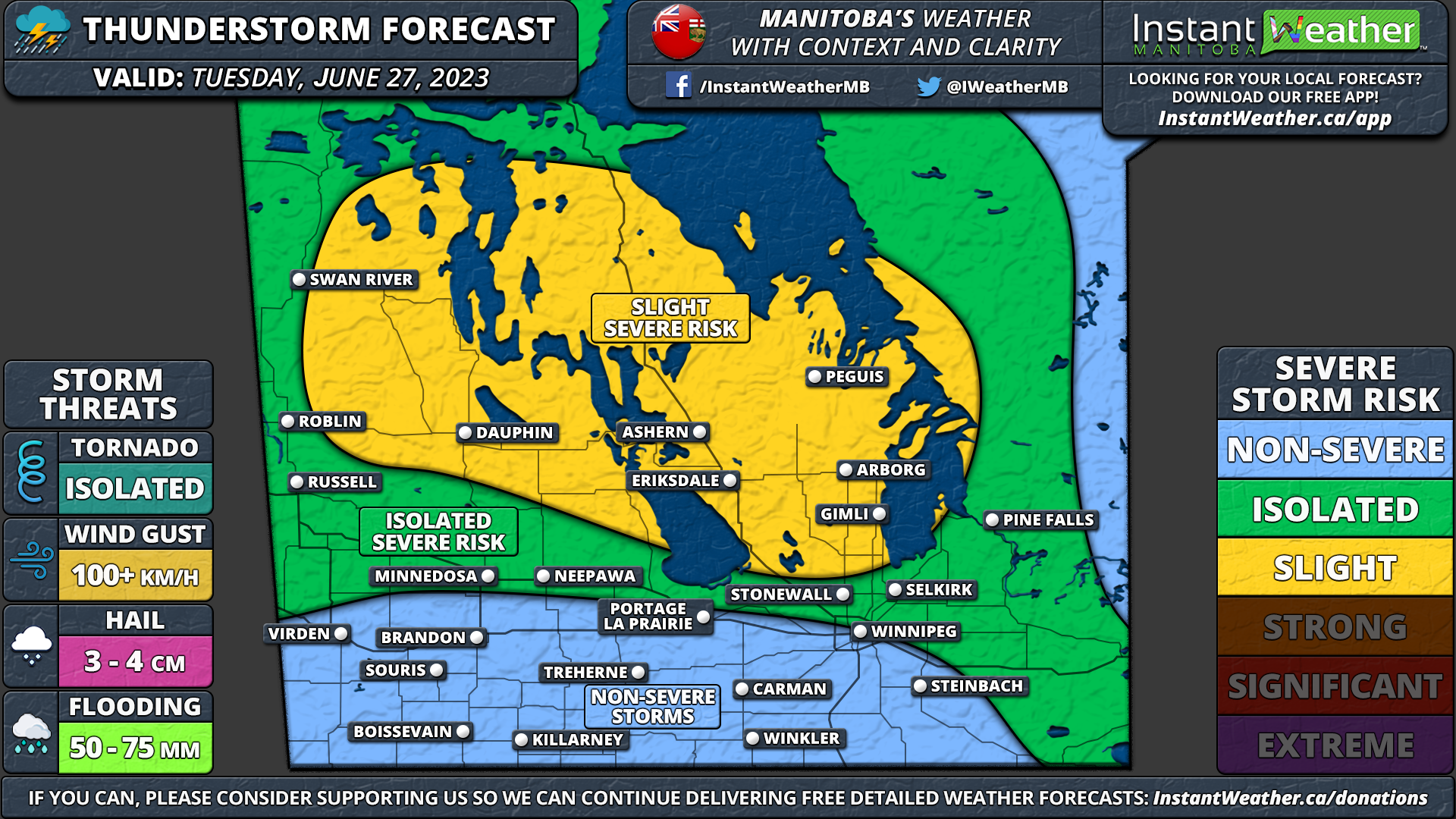
MANITOBA: Thunderstorm Forecast for Tuesday, June 27, 2023


FORECAST DISCUSSION

Scattered thunderstorms are expected to affect much of Southern Manitoba throughout the afternoon and evening on Tuesday. The environment is favourable for some of these storms, particularly in the Dauphin and Interlake region to become severe. As such, we have given this region a ‘slight’ risk of severe weather while the isolated threat is more expansive including Winnipeg. Main risks include up to golf ball-sized hail, 100 km/h wind gusts and even an isolated tornado can’t be ruled out.

MANITOBA: Thunderstorm Forecast for Monday, June 26, 2023


FORECAST DISCUSSION

There is the risk of thunderstorms in Western Manitoba during the afternoon and evening on Monday. A few of these storms may reach severe levels, especially in Southwestern Manitoba. The main risks include 90 km/h wind gusts and up to quarter-sized hail. Funnel clouds are also possible which in rare cases, can touch down and become a landspout tornado.

MANITOBA: Thunderstorm Forecast for Wednesday, June 21, 2023


FORECAST DISCUSSION

Isolated thunderstorms are expected to impact Southeastern Manitoba near the Ontario border on Wednesday afternoon and evening. Current indications suggest they should remain non-severe, but an odd severe storm can’t be ruled out. Although, the confidence isn’t high enough to support an isolated severe risk on our map.