Snow Squall Threat Continues Into Wednesday in Parts of Southern Ontario With an Additional 10 to 20cm of Snow Possible
/It has been an active start to the week around Lake Huron and Georgian Bay, with intense snow squall activity bringing significant snowfall accumulation and near-zero visibility.
Some locations have already witnessed upwards of 20-30cm of snow over the last two days, with the anticipation of snow squalls to drift back north to regions east of Lake Huron and Georgian Bay late Tuesday. Another day of snow squalls is expected on Wednesday; however, they won't be as intense as Tuesday’s squalls and will affect areas further north.
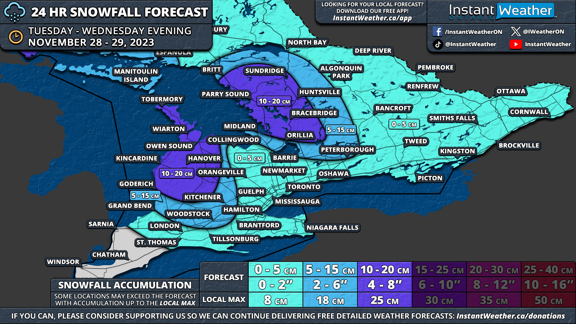
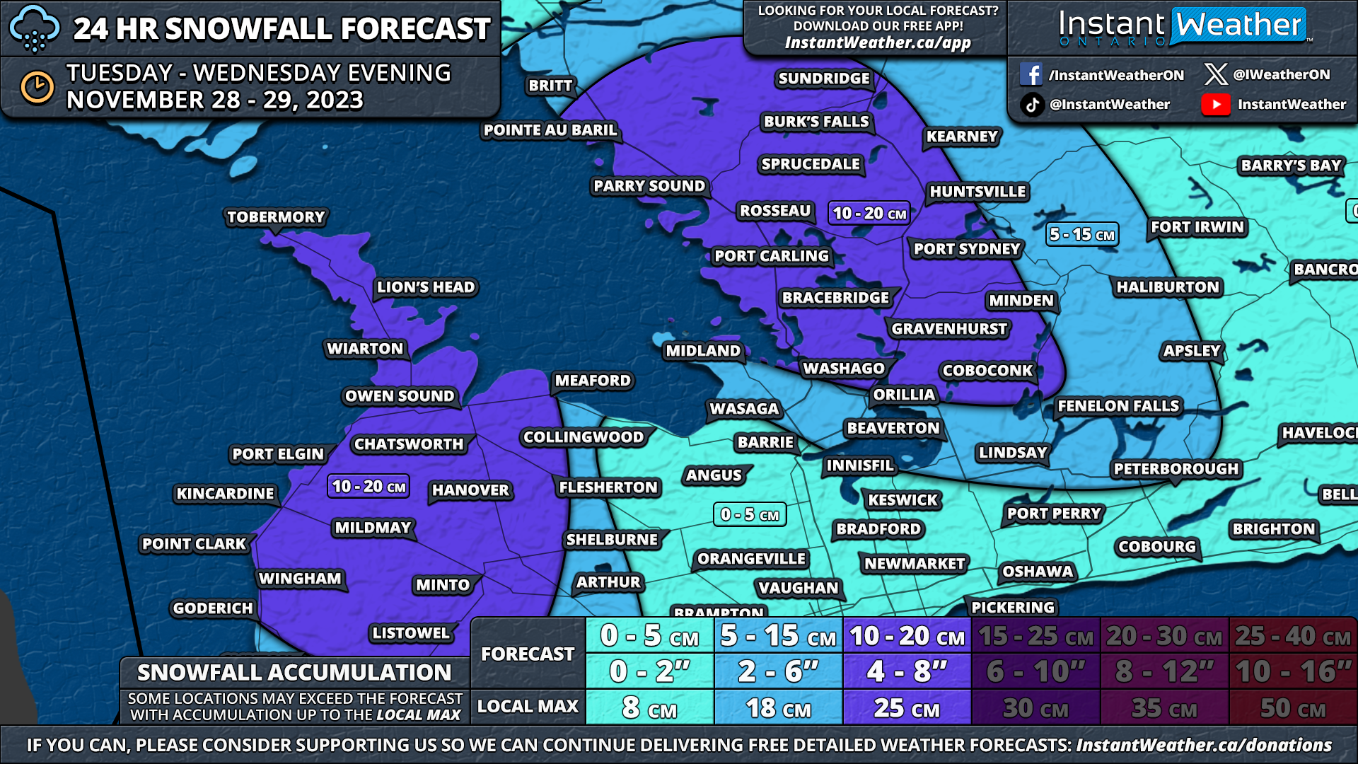
Additional snowfall over the next 24 hours, between Tuesday and Wednesday evening, could range from 10-20cm in the hardest-hit regions. As some locations have already seen 20-30cm of snow from earlier squalls, overall snowfall totals since Sunday could approach 30-40cm!
The main snow squall band of Lake Huron currently stretches from Goderich through Perth County and into the Woodstock area. Meanwhile, the Georgian Bay squall is hammering the Wasaga Beach, Barrie, and Keswick areas.
This will persist for a few more hours into the early evening before we expect a shift in the wind direction to a more westerly to southwesterly flow overnight.
As the winds shift, this will cause the snow squall activity to drift northwards, with the Lake Huron squall moving into the Grey-Bruce region and the Georgian Bay squall targeting the Muskoka and Parry Sound regions.
Expect poor driving conditions mainly east of Georgian Bay, along with the Bruce Peninsula throughout the morning on Wednesday. Another day of school bus cancellations is likely due to rapid snowfall accumulation and reduced visibility.
It appears that the snow squalls on Wednesday will be somewhat more disorganized compared to what we saw from Monday evening into Tuesday. A wide swath of the eastern shoreline of Georgian Bay from Sundridge down to Gravenhurst will experience moderate to heavy snow into Wednesday afternoon.
By Wednesday afternoon, the activity could briefly become more organized into what could be a strong squall stretching from Parry Sound into the North Bay region, although it likely will only last for a few hours. Scattered lake-effect snow will continue throughout the rest of Wednesday, tapering off fully by the evening.
Due to the shift in wind direction, there could be a heavy burst of snow across the GTA and Eastern Ontario late Wednesday as the remnants of the snow squalls slide to the southeast. This won’t have much of a significant impact but could bring a fresh dusting of snow.
While the more spread-out lake-effect activity will help avoid any major accumulation in a focused region, this will result in a larger area seeing some notable accumulation over the next 24 hours.
General snowfall totals should end up between 10 to 20cm in regions including the Bruce Peninsula, Owen Sound, Hanover, Kincardine, Wingham, Listowel, Parry Sound, and Muskoka. It’s possible a few areas could approach 25cm in localized pockets. This is on top of the previous snowfall from the last two days in these areas.
Surrounding regions inland from Lake Huron and Georgian Bay can expect around 5-10cm of additional snowfall, with perhaps as much as 15cm in localized areas. Keep in mind that this is less certain as it will depend on the exact strength and location of the snow squalls.
Less than 5cm is expected for the rest of Southern Ontario, with most of that coming late Wednesday as the decaying snow squall slides through.
Snow squalls are also expected to return to areas southeast of Lake Superior by Tuesday evening and continue through Wednesday. The hardest-hit area appears to be the corridor between Wawa and Sault Ste. Marie. Between 10 to 20cm of snow is possible by the end of Wednesday.
Further north, a weak system will slide across Northwestern Ontario late Wednesday, bringing up to 5-10cm of snow to areas around Thunder Bay and to the northwest towards the Manitoba border.


