High Risk of Grinchmas: Hopes of a ‘White Christmas’ This Year Dashed Across Much of Ontario
/What a difference a year can make! Last year at this time, Ontario was battling a historic blizzard that blanketed some areas with over 100cm of snow around Christmas. Despite the mild start to the month, those dreaming of a ‘White Christmas’ still held onto a sliver of hope that the weather pattern would shift, possibly mirroring last year's conditions and ensuring a snowy Christmas morning.
Now, with less than five days until Christmas, it's becoming more probable that much of Southern Ontario, and even parts of Northern Ontario, will see a ‘Green Christmas’ this year. The past week has been a temperature rollercoaster, with record highs and lake-effect snow events that brought significant snowfall to the snowbelt region.
However, the snow accumulation quickly melted in the following days due to a return of warmer air. As a result, Southern Ontario currently has no snow cover, making the prospect of a ‘White Christmas’ dependent on imminent snowfall.
For the rest of the week, temperatures will drop, with morning lows hitting the negative teens in Central and Eastern Ontario. While it will certainly feel like winter, the lack of precipitation over the next few days means it won't look like it.
The weekend forecast indicates a shift, with milder air bringing temperatures above freezing across Southern Ontario. This warmth will likely cause the snowpack in Central and Eastern Ontario, which accumulated earlier this week, to melt away. Light rain expected late Saturday into Sunday will further contribute to this melting.
If the current trends continue, this Christmas could be among the warmest in recent memory. Temperatures in Southwestern Ontario and the Golden Horseshoe are expected to rise into the double digits, virtually assuring a ‘Green Christmas’ in these areas.
Eastern and Central Ontario might still experience temperatures near freezing on Christmas morning, keeping alive the slim possibility of a ‘White Christmas’. However, this would require either unexpected snow on Christmas Eve or the survival of the existing snowpack, enough to surpass the 2cm ‘White Christmas’ threshold.
Further north, across Algonquin Park and near the Quebec border, temperatures are more likely to remain around the freezing mark over the weekend.
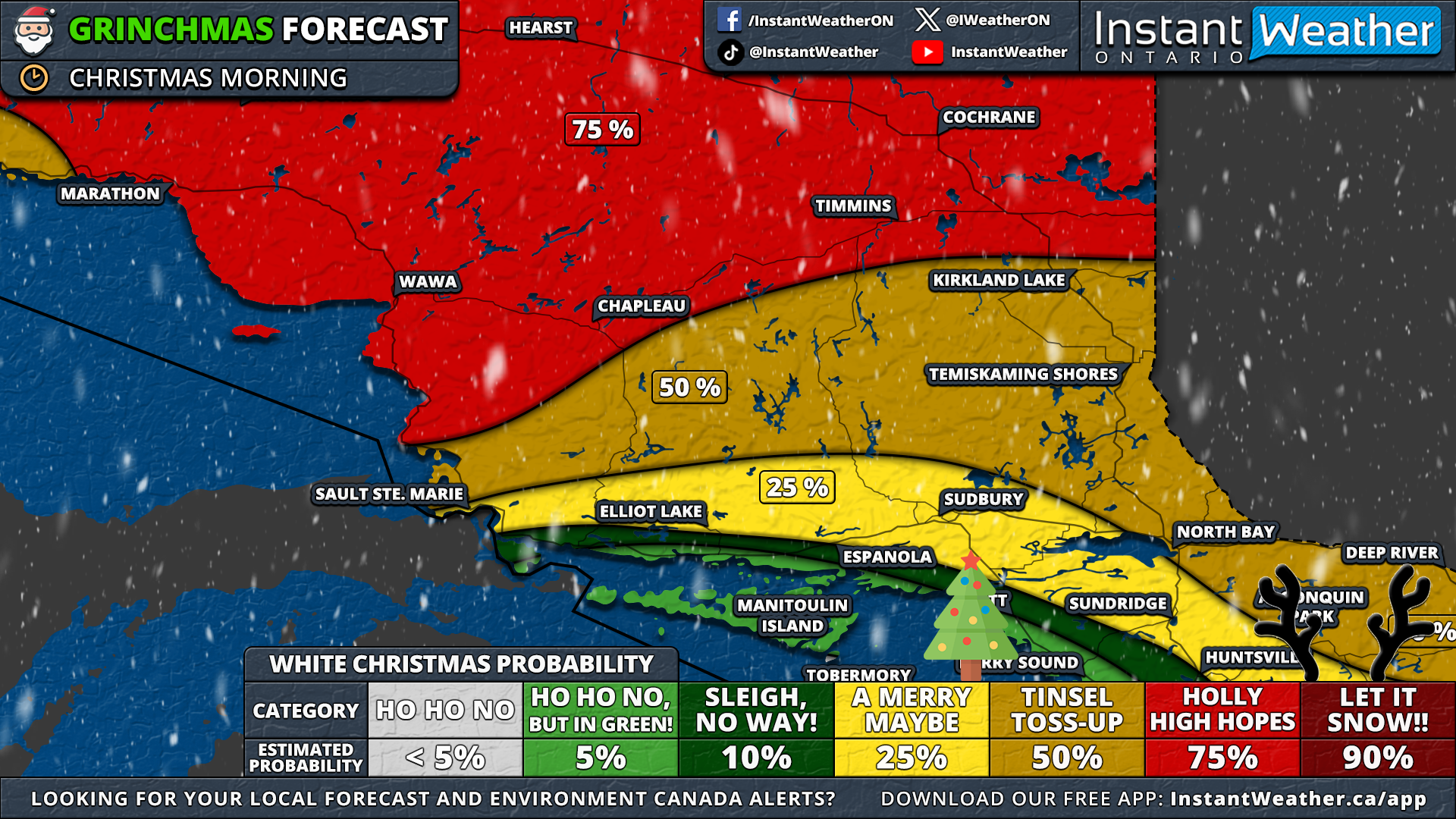
A ‘White Christmas’ is usually given in Northern Ontario, but this year, even some northern areas face the risk of a ‘Grinchmas’. In southern parts of Northeastern Ontario, including Sudbury and North Bay, the chances of a ‘White Christmas’ are between 25 to 50%. With little existing snowpack and no expected snow by Christmas morning, their prospects are uncertain.
The eastern shoreline of Lake Superior, having experienced significant snowfall from earlier squall events, stands a better chance. More northern areas like Timmins and Cochrane could see fresh snow early on Christmas morning, increasing their chances of a picture-perfect ‘White Christmas’ with falling snowflakes.
In Thunder Bay, whether there will be snow on the ground for Christmas is uncertain. Rain expected on Christmas Eve might melt any existing snow, though some morning snowfall is possible. It remains to be seen if this will lead to significant accumulation.
For a sure ‘White Christmas’, one must venture far north in Ontario, where the snowpack is substantial and less affected by the warmer temperatures leading up to the holiday. Regions like Red Lake, Armstrong, and Fort Hope have a 90% likelihood of experiencing a ‘White Christmas’.
Of course, this forecast could change if there's a surprise snowfall event before Christmas. But as it stands, it looks like the Grinch might have his way this year!


