UPDATE: Clouds May Move Out Just in Time for the Solar Eclipse on Monday in Parts of Southern Ontario at the Expense of Eastern Ontario

NOTE: YOU CAN CLICK ON THE MAP TO OPEN A ZOOMABLE IMAGE

We are on the eve of the total solar eclipse set to dim the skies across Southern Ontario on Monday. With the event about 24 hours away, our confidence in the viewing conditions within our region is sharpening. Clear skies are crucial for those looking to fully experience the eclipse, a phenomenon eagerly awaited by many for years.

The experience of a total solar eclipse differs significantly under clear versus cloudy skies. Clear conditions allow observers to witness the dramatic dimming of daylight, a noticeable drop in temperature, and the visibility of stars and planets.

The eclipse's most breathtaking moment, the emergence of the sun's corona, is visible only during totality, revealing delicate, radiant strands extending from the moon's silhouette, an image no camera or telescope capturing partial phases can replicate.

Under cloudy conditions, while some cooling and dimming effects may still be perceptible, the visual spectacle is significantly diminished. Clouds mask the corona, stars, and planets, greatly reducing the visual impact of the eclipse.


GOOGLE AD (NOT ENDORSED BY INSTANT WEATHER)

SAFETY WARNING

To safely enjoy the eclipse, it's imperative to use ISO 12312-2 certified solar glasses. Directly observing the sun, even during an eclipse, can cause serious damage to your eyes. You can only view the eclipse without the glasses during the few minutes of totality. Solar glasses are designed to block harmful solar radiation and protect your eyes while allowing you to safely witness the event.

Never use makeshift viewing solutions like sunglasses or homemade filters, as they do not offer adequate protection against the sun's rays. Also, remember that the same rules apply to taking pictures with your phone. The sun can damage your camera’s sensors if you don’t have the proper solar filter (such as the same solar glasses for your eyes).


your guide to the eclipse:


Our initial forecast pointed to the possibility of clouds moving into Southern and Northern Ontario from late Sunday into Monday morning. This outlook holds, according to the latest models, albeit with slight adjustments in the anticipated locations of the densest cloud cover.

A key change concerns Eastern Ontario, where the front edge of the cloud cover is now forecasted to arrive several hours earlier than previously thought. Consequently, areas such as Kingston, Belleville, and Brockville might experience increasing cloudiness before the eclipse begins, potentially obscuring views of the later stages, including totality around 3 PM.

In the Ottawa Valley, cloud coverage remains a possibility, though a very narrow strip of Extreme Eastern Ontario, around Cornwall, is expected to maintain clear skies for the majority of the eclipse. While high-level clouds may still be present, they shouldn't hinder eclipse viewing, as the sun's light should penetrate through.

This shift in cloud movement toward the east spells good news for those in Deep Southwestern Ontario. We now have increased confidence that locations southwest of London, including Sarnia, Chatham, Leamington, and Windsor, will enjoy mostly clear skies at the eclipse's peak.

Even parts of Southwestern Ontario, extending from the southwestern shore of Lake Huron to the Kitchener/Waterloo region, might see clouds dissipate in time for the eclipse.


GOOGLE AD (NOT ENDORSED BY INSTANT WEATHER)

The outlook for the Golden Horseshoe, including the Greater Toronto Area and Niagara region, is more uncertain. Clouds are expected to obscure the early stages of the eclipse in the afternoon, but recent high-resolution models suggest possible breaks in the cloud cover around 3 PM, coinciding with the eclipse's maximum.

There's hope that this trend towards earlier cloud clearance continues, potentially offering clear views over the Niagara region right in time for totality. While not guaranteed, the possibility remains, so keep your fingers crossed.

In contrast, Central Ontario and the Georgian Bay shoreline are expected to be under thick clouds during the eclipse, likely obstructing views. Those in these areas hoping to witness the eclipse may need to consider travelling to clearer locations.


NOTE: YOU CAN CLICK ON THE MAP TO OPEN A ZOOMABLE IMAGE

In Northern Ontario, prospects for viewing the partial solar eclipse are less favourable, with extensive cloud cover predicted from Georgian Bay to the Lake Superior shoreline.

Locations such as Elliot Lake, Sault Ste. Marie, Wawa, and Marathon are unlikely to have a clear view of the eclipse. Cloud coverage in Northeastern Ontario is expected to be mostly dense, though it may become more scattered further north.


GOOGLE AD (NOT ENDORSED BY INSTANT WEATHER)

NOTE: YOU CAN CLICK ON THE MAP TO OPEN A ZOOMABLE IMAGE

As we look at Northwestern Ontario, the viewing conditions are quite poor, especially around the Lake Superior shoreline including Thunder Bay, Kenora and the Armstrong region. Thick clouds will likely make the eclipse hard to view.

Clouds Threaten to Spoil the Solar Eclipse on Monday in Parts of Ontario but Not for Everyone

CLICK HERE FOR THE UPDATED FORECAST

NOTE: YOU CAN CLICK ON THE MAP TO OPEN A ZOOMABLE IMAGE

The countdown is on for the total solar eclipse set to darken the skies across Southern Ontario on Monday. As the big day approaches, we're gaining a clearer understanding of the expected weather conditions during the eclipse. Clear skies are essential for experiencing the full marvel of the eclipse, an event eagerly anticipated by many for years.

Experiencing a total solar eclipse varies dramatically under clear versus cloudy skies. Clear skies allow you to witness the significant dimming of daylight, a noticeable drop in temperature, and the emergence of stars and planets.

The eclipse's crowning moment, the visibility of the sun's corona, occurs exclusively during totality. This presents the corona's delicate, luminous strands extending from the moon's silhouette in a spectacle unmatched by any camera or telescope viewing partial phases.

However, under cloudy skies, though you may still observe a cooling and dimming effect, the visual wonder is significantly obscured. Clouds conceal the corona, stars, and planets, greatly diminishing the eclipse's visual splendour.


GOOGLE AD (NOT ENDORSED BY INSTANT WEATHER)

SAFETY WARNING

To safely enjoy the eclipse, it's imperative to use ISO 12312-2 certified solar glasses. Directly observing the sun, even during an eclipse, can cause serious damage to your eyes. You can only view the eclipse without the glasses during the few minutes of totality. Solar glasses are designed to block harmful solar radiation and protect your eyes while allowing you to safely witness the event.

Never use makeshift viewing solutions like sunglasses or homemade filters, as they do not offer adequate protection against the sun's rays. Also, remember that the same rules apply to taking pictures with your phone. The sun can damage your camera’s sensors if you don’t have the proper solar filter (such as the same solar glasses for your eyes).


your guide to the eclipse:


The weather forecast offers a mix of optimism and caution. Some areas in the path of totality in Southern Ontario might face cloudy conditions, potentially obscuring the eclipse. Yet, certain regions in Eastern Ontario and along the Lake Erie shoreline are expected to enjoy clear skies, offering an unobstructed view of the eclipse.

The latest models predict clouds moving in from the southwest late Sunday, leading to overcast conditions in much of Southwestern, Central Ontario, and the Golden Horseshoe by Monday morning. These clouds are expected to spread eastward throughout the morning and early afternoon, with discrepancies among models regarding the extent and timing of the cloud cover.


GOOGLE AD (NOT ENDORSED BY INSTANT WEATHER)

By early afternoon, clearing is anticipated in Deep Southwestern Ontario, just in time for the eclipse's start around 2 PM. In contrast, from Niagara Falls through the GTA to Central Ontario, clouds are likely to persist, though intermittent breaks might still offer glimpses of the eclipse.

Eastern Ontario faces a race against time, with increasing cloudiness expected. The northeastern tip, including Cornwall, may remain clear until later in the afternoon, offering potentially favourable conditions for eclipse viewing. Kingston and Belleville should be mostly clear to start, but again, clouds will increase in coverage during the eclipse so hopefully it can hold off until after totality occurs.

NOTE: YOU CAN CLICK ON THE MAP TO OPEN A ZOOMABLE IMAGE

In Northern Ontario, prospects for viewing the partial solar eclipse are less favourable, with extensive cloud cover predicted from Georgian Bay to the Lake Superior shoreline.

Locations such as Elliot Lake, Sault Ste. Marie, Wawa, and Marathon are unlikely to have a clear view of the eclipse. Cloud coverage in Northeastern Ontario is expected to be mostly dense, though it may become more scattered further north and east.


GOOGLE AD (NOT ENDORSED BY INSTANT WEATHER)

NOTE: YOU CAN CLICK ON THE MAP TO OPEN A ZOOMABLE IMAGE

As we look at Northwestern Ontario, the viewing conditions are quite poor especially around the Lake Superior shoreline including Thunder Bay and into the Armstrong region. Thick clouds will likely make the eclipse hard to view. There is some chance that those closer to the Manitoba border may see some breaks in the clouds, but it’s unlikely.

Niagara Region Declares State of Emergency Ahead of Total Solar Eclipse

The Niagara Region has officially declared a State of Emergency in anticipation of the large number of visitors expected to arrive for the total solar eclipse on April 8th, which is being hailed as one of the premier viewing opportunities in Canada. In preparation for the arrival of thousands of eclipse enthusiasts, Regional Chair Jim Bradley made the announcement on March 28th, invoking the Emergency Management and Civil Protection Act (EMCPA).


GOOGLE AD (NOT ENDORSED BY INSTANT WEATHER)

This step is taken as a precaution to ensure the safety and well-being of both the residents and the visitors coming to witness this unique celestial phenomenon. Local governments, emergency services, schools, and various organizations are working in unison, coordinating efforts with the Province and key partners to ensure a memorable yet safe eclipse viewing experience.

The declaration is set to bolster the region's capabilities in handling large crowds, maintaining essential infrastructure, and responding promptly to any emergencies that might occur. Officials are highlighting the need for preparedness among those planning to view the eclipse, advising adherence to safety guidelines such as the use of ISO 12312-2 certified eclipse glasses and avoiding makeshift viewing methods that can endanger eye health.


GOOGLE AD (NOT ENDORSED BY INSTANT WEATHER)

To mitigate the impact of expected large crowds and potential delays, residents and visitors are encouraged to prepare in advance. Recommendations include filling up vehicles with gas, shopping for groceries, and completing errands well before eclipse day to avoid unnecessary congestion. Safe travel practices on April 8th are also emphasized, with advisories against stopping or getting out of vehicles on highways to watch the eclipse.

Given the significance of the event, most schools in the Niagara region will be closed, prompting parents to make alternate childcare arrangements and to educate their children on how to safely observe the eclipse.


GOOGLE AD (NOT ENDORSED BY INSTANT WEATHER)

Foggy & Warm Days Ahead for Southern Ontario: Widespread Dense Fog Starting This Weekend and Double-Digit Temperatures on Monday

NOTE: YOU CAN CLICK ON THE MAP TO OPEN A ZOOMABLE IMAGE

March has ushered in a tranquil period for Southern Ontario following the whirlwind of weather experienced in the final stretch of February. With temperatures climbing above the seasonal norm for the weekend, an area of fog has begun to descend across the region, foreshadowing a week that will start with several mornings blanketed in dense mist. While light drizzle is expected to accompany the fog, significant rainfall is not anticipated.

We are also watching the potential for what could be some of the warmest air we’ve seen this year so far across Southern Ontario starting Monday.


GOOGLE AD (NOT ENDORSED BY INSTANT WEATHER)

NOTE: YOU CAN CLICK ON THE MAP TO OPEN A ZOOMABLE IMAGE

As of Saturday afternoon, fog has started to materialize in parts of Southern Ontario. Current models predict that this fog will thicken as the day progresses into the night, with much of Eastern, Central, and Southwestern Ontario, along with the Golden Horseshoe, expected to face near-zero visibility conditions overnight and into Sunday morning.

NOTE: YOU CAN CLICK ON THE MAP TO OPEN A ZOOMABLE IMAGE

Sunday will see the fog dissipate to some degree after sunrise, but it may persist in certain areas throughout the day. This break will be short-lived, as a more extensive blanket of fog is forecasted to envelop almost all of Southern Ontario by Sunday evening, remaining into Monday morning.

This persistent fog could lead to school bus delays or cancellations on Monday, so it would be wise to prepare for potential disruptions. The fog is slated to make a return on Monday night, continuing into Tuesday, which could once again impact school transportation for a second consecutive day.


GOOGLE AD (NOT ENDORSED BY INSTANT WEATHER)

The weather story of this week continues with a resurgence of mild conditions, particularly pronounced on Monday through Wednesday. A swath of the area will experience highs in the double digits, with the Windsor region potentially flirting with the 20°C mark on Monday for the second time this year!

As Tuesday gives way to Wednesday, steady rainfall is expected to sweep across Southern Ontario, predominantly in the latter half of Tuesday, persisting into Wednesday. Rainfall totals are forecasted to be modest, in the range of 5-10mm by Wednesday's end. Moreover, the potential for a thunderstorm on Tuesday cannot be discounted, although the severity is not anticipated to come anywhere close to what we saw last week.


GOOGLE AD (NOT ENDORSED BY INSTANT WEATHER)

Flash Freeze Threatens Wednesday Afternoon/Evening Commute Across Southern Ontario

NOTE: YOU CAN CLICK ON THE MAP TO OPEN A ZOOMABLE IMAGE

After experiencing a series of thunderstorms and Ontario's first 20°C temperature of the season recorded in Windsor on Tuesday, we're on the brink of a significant shift as we head into Wednesday. It feels like we're at the peak of a roller coaster, about to dive back down into winter-like temperatures.

This transition will be marked by a sharp cold front, leading to a rapid decrease in temperatures. Expect to see temperatures plummet from the upper single digits or low teens to well below the freezing mark within just a few hours on Wednesday. With roads and surfaces still wet from previous rainfall, a 'flash freeze' is almost certain, where all moisture on surfaces will quickly freeze, turning to ice.


GOOGLE AD (NOT ENDORSED BY INSTANT WEATHER)

The severity of the flash freeze will differ across regions, with Central and Eastern Ontario witnessing the most dramatic temperature drops — from near double digits to the freezing mark within an hour or two in the afternoon to early evening. In Southwestern Ontario and the Golden Horseshoe, the temperature will initially drop to just above freezing, with a more gradual descent toward the freezing mark. This difference in temperature change rate will significantly impact the flash freeze threat, with a slower onset for these areas.

Following the cold front, lake effect snow will begin to form around Lake Huron and Georgian Bay from Wednesday evening into Thursday. While specifics will be detailed in a separate forecast, it's likely that traditional snowbelt regions could see upwards of 20-30cm of snow by week's end. However, this snow won't linger, as milder air is forecasted to return by the weekend.

NOTE: YOU CAN CLICK ON THE MAP TO OPEN A ZOOMABLE IMAGE

Wednesday morning will greet you with temperatures well above seasonal, in the mid to upper single digits through Central and Eastern Ontario, and possibly even double digits in the southwest. This warmth is extraordinary for this time of the year, especially considering it will occur in the morning, typically cooler than peak daytime temperatures. Windsor, Chatham, and Sarnia could see temperatures ranging from 12 to 15°C, making them the expected hotspots.

The onset of change will start later in the morning as the cold front approaches. Much of Southern Ontario will still experience mild temperatures of 6 to 9°C, except along the Lake Huron shoreline, where temperatures will be closer to 3°C, and near-freezing on the Bruce Peninsula.


GOOGLE AD (NOT ENDORSED BY INSTANT WEATHER)

NOTE: YOU CAN CLICK ON THE MAP TO OPEN A ZOOMABLE IMAGE

Northeastern Ontario will display the stark contrast in temperature gradients. North Bay and Sudbury will enjoy continued warmth from the south, with temperatures of 2 to 6°C, while Elliot Lake and areas towards Temiskaming Shores will be among the first to experience the cold plunge raging from -3 to -12°C.

NOTE: YOU CAN CLICK ON THE MAP TO OPEN A ZOOMABLE IMAGE

By early afternoon on Wednesday, the cold air will start to dominate, pushing the warm air east and causing temperatures to drop below freezing across much of Southwestern and Central Ontario. The Grey-Bruce region will see temperatures between -3°C to -5°C by 1 PM. The freezing line will sweep across Central Ontario and the Golden Horseshoe early in the afternoon.


GOOGLE AD (NOT ENDORSED BY INSTANT WEATHER)

NOTE: YOU CAN CLICK ON THE MAP TO OPEN A ZOOMABLE IMAGE

Northeastern Ontario will see Sudbury's temperatures drop from 3-5°C in the morning to near -9°C by the afternoon. While North Bay will follow Sudbury’s lead by the mid to late afternoon hours.

NOTE: YOU CAN CLICK ON THE MAP TO OPEN A ZOOMABLE IMAGE

By 4 PM, the last areas to experience the drop will be in the Ottawa valley, with temperatures nearing 12°C in the Brockville and Cornwall area. The rest of Southern Ontario will have already experienced the temperature drop and will hover at or slightly below the freezing mark through the afternoon.


GOOGLE AD (NOT ENDORSED BY INSTANT WEATHER)

NOTE: YOU CAN CLICK ON THE MAP TO OPEN A ZOOMABLE IMAGE

As night falls, the entire region of Southern Ontario will see temperatures plummet, with Eastern Ontario experiencing the drop around dinner time. Expect temperatures to range from -3 to -5°C in Southwestern Ontario and the Golden Horseshoe, while Central Ontario might see temperatures dip into the negative double digits.

By Thursday morning, the cold will intensify, with wind chills potentially making it feel like the -20s in parts of Southern Ontario. Be sure to bundle up before heading out the door on Thursday!

Weather Whiplash in Ontario With Record-Breaking Heat, Severe Thunderstorm Risk & Flash Freeze This Week

Get ready for a wild weather ride, Ontario! The old saying will hold true this week: "If you don't like the weather in Ontario, just wait five minutes—it'll change!" And change it will, with a full spectrum of seasons unfurling over the next 48 hours.

As we previously hinted, a ‘heatwave’ is set to roll in for Tuesday and Wednesday, with temperatures climbing into the teens. Parts of Deep Southwestern Ontario are even teasing the 20°C mark, according to some models!


GOOGLE AD (NOT ENDORSED BY INSTANT WEATHER)

Thunderstorms are on the agenda for Tuesday, starting with morning storms and a potential severe risk by the afternoon and evening.

Fog, a recurring theme this season, is slated to make a comeback in certain areas on Tuesday and Wednesday. This will be accompanied by heavy rain, dumping 15-30mm by Wednesday morning. For parts of Northern Ontario, we could be looking at significant snowfall totals as the cold air hangs on there. This includes Kenora, Dryden, Kapuskasing, Cochrane and Timmins.

Take a look at Windsor's 10-day forecast—it's a real temperature roller coaster. We're climbing to the first high on Wednesday with temperatures soaring over 15°C, then taking a dive back to near seasonal norms by Thursday.

But hold on tight! We're heading back up for another warm spell this weekend, with the mercury potentially flirting with the 20°C mark by Monday.

For some perspective, the average high for Windsor at this time of year hovers around 3°C. However, the upcoming forecast anticipates highs that will consistently top the seasonal average. And this pattern of temperature swings? It's set to stick around into the early days of March.

Download our free app to view your local forecast.


GOOGLE AD (NOT ENDORSED BY INSTANT WEATHER)

But don't pack away your winter gear just yet!

Remember, it's still February, despite what the balmy temperatures might suggest. Winter is gearing up for a comeback by Wednesday morning and afternoon. A sharp cold front will sweep through the province, one of the steepest we've seen in quite some time, with temperatures plummeting from the teens to below freezing in just a few hours.

Given the expected rain and mixed precipitation during this cooldown, we're likely to see road conditions turn treacherous with ice on Wednesday. A tricky commute is on the cards for Wednesday afternoon, and we can't dismiss the potential for school bus cancellations if the flash freeze risk materializes as the models predict.


GOOGLE AD (NOT ENDORSED BY INSTANT WEATHER)

From late Wednesday into Thursday, snow squalls are expected to revisit the usual snowbelt regions, with wind chills plunging to near -20°C—a stark contrast to Tuesday's near-record warmth.

And the temperature roller coaster doesn't stop there. As we look towards the weekend and into early next week, another significant warm-up is on the horizon. Because these rapid temperature fluctuations are definitely healthy for our ecosystem! 🫠

We're putting together a detailed forecast, complete with several maps to navigate this complex weather pattern. It's a bit of a task, so bear with us as we compile all the necessary information. Stay tuned!


GOOGLE AD (NOT ENDORSED BY INSTANT WEATHER)

Possible ‘Heatwave’ to End February in Ontario?

NOTE: YOU CAN CLICK ON THE MAP TO OPEN A ZOOMABLE IMAGE. DATA FROM Weatherbell

Are you ready to feel the heat, Ontario? 🥵

Confidence is growing for another surge of warmer temperatures as we move into the final week of February. Despite many enjoying a taste of winter weather last week across Southern Ontario, it seems that was merely a brief pause in the mild winter we have been experiencing this season.

As of Tuesday, the shift towards milder temperatures is already noticeable, with parts of Southwestern Ontario experiencing mid to upper single-digit temperatures. This marks a significant change from just a few days ago when overnight lows plunged into the negative teens!


GOOGLE AD (NOT ENDORSED BY INSTANT WEATHER)

The rest of the week promises more of the same, with temperatures staying in the single digits, slightly above the seasonal average.

Additionally, we're anticipating some rain from late Wednesday into Thursday, with expected totals between 15-25mm. The heaviest rainfall is predicted along the Lake Erie and Lake Ontario shorelines as the center of the low-pressure system is forecasted to pass just south of the Great Lakes.

However, a brief cooldown is on the horizon for the weekend, leading to morning lows of -10 to -20°C throughout Central and Eastern Ontario on Saturday. Given the open state of the lakes, we might also see some lake effect snow in the usual snowbelt areas.

This cold snap will be short-lived, as temperatures above freezing are expected to return by Sunday, with even warmer air moving into the province for the last days of February.


GOOGLE AD (NOT ENDORSED BY INSTANT WEATHER)

While it's too early to specify exact temperatures, it appears many areas will experience temperatures 15 to 20°C above the norm.

Typically, daytime temperatures around this time of year hover around 0°C, suggesting that by mid-next week, temperatures could reach the mid to upper teens, depending on your location.

The warmest air is anticipated in the southwestern region, including Sarnia, Windsor, and Chatham. For instance, our app is currently forecasting a high of 16°C in Windsor next Tuesday.

While not a certainty, there are indications of a possible thunderstorm risk around the middle of next week. Though unlikely to be severe, it's certainly something we'll be monitoring.

If you were hoping for winter to linger and compensate for the mild season we've experienced so far, it seems that won't be the case.


GOOGLE AD (NOT ENDORSED BY INSTANT WEATHER)

Willie Was Right! Early Spring-Like Weather for Southern Ontario; Record Breaking Double-Digit Temperatures on Friday

NOTE: YOU CAN CLICK ON THE MAP TO OPEN A ZOOMABLE IMAGE

At the beginning of February, Wiarton Willie, who did not see his shadow, predicted an early spring for Southern Ontario. It appears that Willie's prediction may indeed reflect the weather pattern as we approach the latter part of this week.

After enjoying several consecutive days of sunshine, this pleasant streak is unfortunately expected to end, with clouds and fog rolling in on Thursday and Friday. It will resemble a Vancouver Or Seattle winter, a trend that has been persistent over the last few months. Early Friday, Southern Ontario will see some scattered showers that will continue throughout the day, but these showers will bring with them a surge of warm air.


GOOGLE AD (NOT ENDORSED BY INSTANT WEATHER)

In parts of Southwestern Ontario and areas of the Golden Horseshoe, temperatures could reach the 10°C mark on both Thursday and Friday. Friday is anticipated to be the warmest day, with temperatures in Deep Southwestern Ontario nearing the mid-teens. Most areas have temperature records ranging from 8°C to 12°C, records that might be shattered on Friday, according to current models.

Those in Windsor, Chatham, Sarnia, London, Woodstock, and Newmarket can expect maximum temperatures between 10 to 14°C, likely making this the warmest area in the province. Near the Lake Erie, Lake Huron, and Lake Ontario shorelines, as well as in the Barrie and Peterborough areas, it will still be quite warm, with temperatures ranging from 8 to 12°C.

In Central and Eastern Ontario, temperatures are predicted to be slightly cooler, falling short of double digits and ranging from 6 to 10°C. Further north, temperatures are expected to hover in the mid-single digits for Algonquin Park and Northeastern Ontario.


In addition to the warmth, fog starting Wednesday night around Lake Erie and the Golden Horseshoe will pose a challenge, with near-zero visibility creating hazardous driving conditions. This may result in some school bus cancellations on Thursday and Friday mornings. The fog is expected to persist into the weekend.


GOOGLE AD (NOT ENDORSED BY INSTANT WEATHER)

Looking ahead to next week, a return to seasonal temperatures around the freezing mark is expected in most areas. There are signs that we might enter a colder pattern by the end of next week, extending into mid-February, potentially bringing several opportunities for accumulating snow later in the month. However, it's still too early to confirm, and the forecast could change!

Canada’s Groundhogs, Lobster Split on if It Will Be an Early Spring This Year

NOTE: YOU CAN CLICK ON THE MAP TO OPEN A ZOOMABLE IMAGE

The curtain has fallen on Groundhog Day 2024, and the forecasts from our esteemed weather-predicting groundhogs—and a lone lobster—are in, offering a split decision that mirrors the vast and varied Canadian landscape.


GOOGLE AD (NOT ENDORSED BY INSTANT WEATHER)

In the Maritimes, Shubenacadie Sam of Nova Scotia brought cheer with his prediction of an early spring, a sentiment supported by Quebec’s new groundhog meteorologist, who is carrying on the legacy of the late Fred la Marmotte with a similar spring-forward forecast.

Lucy the Lobster, however, provided a stark contrast, casting her shadow on the seabed and predicting a longer winter for Nova Scotia.


GOOGLE AD (NOT ENDORSED BY INSTANT WEATHER)

The spring chorus was joined by Ontario's Wiarton Willie and the famed Punxsutawney Phil from the United States, both of whom failed to see their shadows, suggesting an early end to winter.

In a surprising twist, the story changed out in the Prairies, as Manitoba Merv observed his shadow, heralding six more weeks of winter.


GOOGLE AD (NOT ENDORSED BY INSTANT WEATHER)

This chilly predictions was later seconded by Alberta's Balzac Billy, who also saw his shadow, adding weight to the wintry forecast.

Now, with an even split of three forecasts for an early spring and three for a prolonged winter, Canadians are left to wonder what the coming weeks will truly hold. Will the hopeful predictions of an early spring prevail, or will the winter warnings ring true?

With this mixed bag of predictions, the end of winter remains as mysterious as the weather itself. Only the passing of the weeks will reveal the true accuracy of our furry and clawed forecasters’ divinations.


GOOGLE AD (NOT ENDORSED BY INSTANT WEATHER)

Blizzard Risk for Southern Ontario on Friday; When Will It Arrive?

Southern Ontario is currently on track to see a high-impact snowstorm starting Friday evening. This storm will bring a brief, but intense burst of snow leading to blizzard conditions in many areas.

Here's a region-based breakdown of the estimated timing. Please note that these are estimates, and actual start times may vary by a few hours. However, this should give you a general idea of when to expect the worst conditions.


FULL FORECAST


The blizzard is expected to begin in Deep Southwestern Ontario in the late afternoon or early evening. Areas like Windsor, Chatham, and Sarnia will likely see conditions worsen between 5-7 PM.

Once the blizzard conditions arrive, they will last for one or two hours before gradually reducing in intensity with moderate snow continuing into Saturday. Although the wind will remain a concern throughout the night so expect some blowing snow.


GOOGLE AD (NOT ENDORSED BY INSTANT WEATHER)

As the heavy snow band moves northeast, it will reach the London, Kitchener, and Goderich area shortly after dinner. The GTA, Hamilton, and Niagara regions should brace for the blizzard around 8-9 PM. Note that some of these areas might have mixed precipitation, which could reduce the severity of the blizzard.

Later in the evening, Central Ontario, including Simcoe County, Kawartha, Peterborough, and Muskoka, will experience heavy snow and strong winds. This is expected to start between 9-10 PM in the south and around 11 PM in the northern areas.


GOOGLE AD (NOT ENDORSED BY INSTANT WEATHER)

Eastern Ontario, including Kingston and the Ottawa Valley, will likely see the blizzard start around 10 PM and around midnight, respectively.

Since it's not feasible to include every location in our graphic, we recommend using the closest listed location for guidance.

High Risk of Grinchmas: Hopes of a ‘White Christmas’ This Year Dashed Across Much of Ontario

NOTE: YOU CAN CLICK ON THE MAP TO OPEN A ZOOMABLE IMAGE

What a difference a year can make! Last year at this time, Ontario was battling a historic blizzard that blanketed some areas with over 100cm of snow around Christmas. Despite the mild start to the month, those dreaming of a ‘White Christmas’ still held onto a sliver of hope that the weather pattern would shift, possibly mirroring last year's conditions and ensuring a snowy Christmas morning.


GOOGLE AD (NOT ENDORSED BY INSTANT WEATHER)

Now, with less than five days until Christmas, it's becoming more probable that much of Southern Ontario, and even parts of Northern Ontario, will see a ‘Green Christmas’ this year. The past week has been a temperature rollercoaster, with record highs and lake-effect snow events that brought significant snowfall to the snowbelt region.

However, the snow accumulation quickly melted in the following days due to a return of warmer air. As a result, Southern Ontario currently has no snow cover, making the prospect of a ‘White Christmas’ dependent on imminent snowfall.

For the rest of the week, temperatures will drop, with morning lows hitting the negative teens in Central and Eastern Ontario. While it will certainly feel like winter, the lack of precipitation over the next few days means it won't look like it.


GOOGLE AD (NOT ENDORSED BY INSTANT WEATHER)

The weekend forecast indicates a shift, with milder air bringing temperatures above freezing across Southern Ontario. This warmth will likely cause the snowpack in Central and Eastern Ontario, which accumulated earlier this week, to melt away. Light rain expected late Saturday into Sunday will further contribute to this melting.

If the current trends continue, this Christmas could be among the warmest in recent memory. Temperatures in Southwestern Ontario and the Golden Horseshoe are expected to rise into the double digits, virtually assuring a ‘Green Christmas’ in these areas.

Eastern and Central Ontario might still experience temperatures near freezing on Christmas morning, keeping alive the slim possibility of a ‘White Christmas’. However, this would require either unexpected snow on Christmas Eve or the survival of the existing snowpack, enough to surpass the 2cm ‘White Christmas’ threshold.

Further north, across Algonquin Park and near the Quebec border, temperatures are more likely to remain around the freezing mark over the weekend.


GOOGLE AD (NOT ENDORSED BY INSTANT WEATHER)

NOTE: YOU CAN CLICK ON THE MAP TO OPEN A ZOOMABLE IMAGE

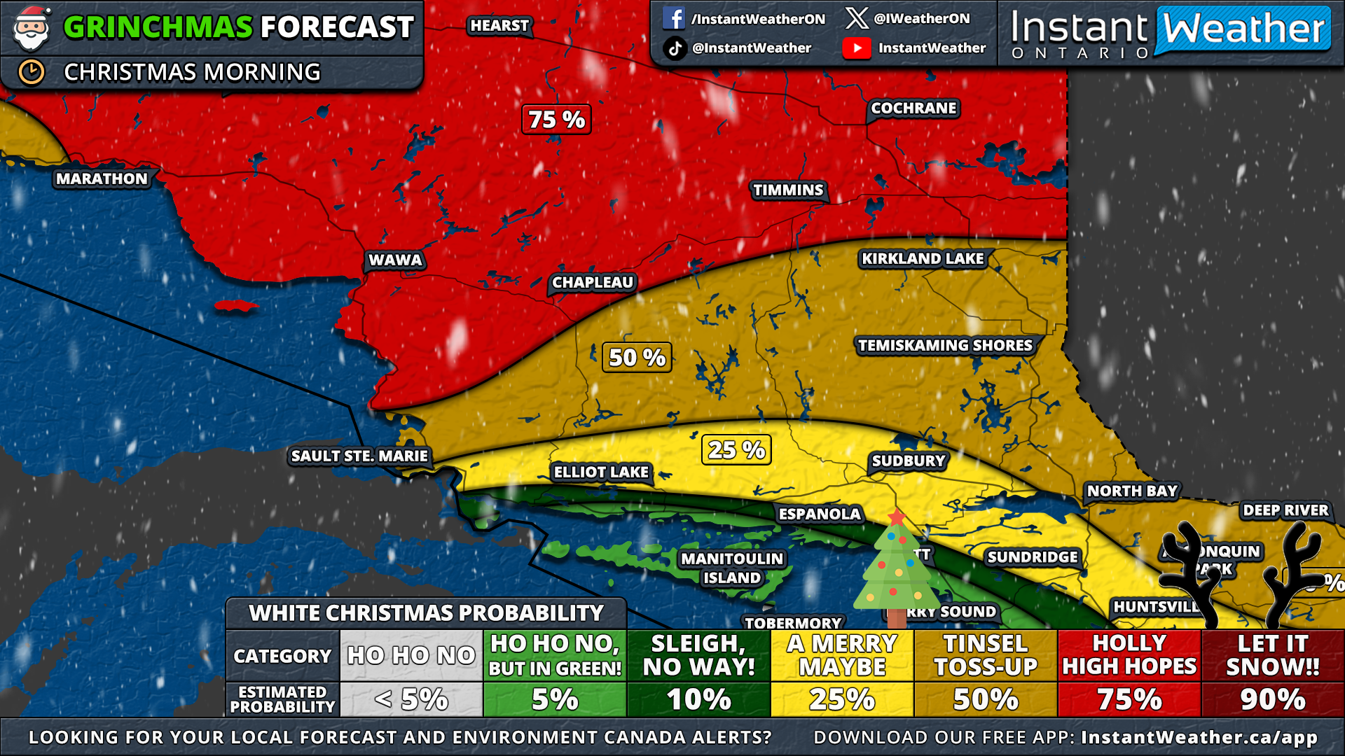
A ‘White Christmas’ is usually given in Northern Ontario, but this year, even some northern areas face the risk of a ‘Grinchmas’. In southern parts of Northeastern Ontario, including Sudbury and North Bay, the chances of a ‘White Christmas’ are between 25 to 50%. With little existing snowpack and no expected snow by Christmas morning, their prospects are uncertain.

The eastern shoreline of Lake Superior, having experienced significant snowfall from earlier squall events, stands a better chance. More northern areas like Timmins and Cochrane could see fresh snow early on Christmas morning, increasing their chances of a picture-perfect ‘White Christmas’ with falling snowflakes.


GOOGLE AD (NOT ENDORSED BY INSTANT WEATHER)

NOTE: YOU CAN CLICK ON THE MAP TO OPEN A ZOOMABLE IMAGE

In Thunder Bay, whether there will be snow on the ground for Christmas is uncertain. Rain expected on Christmas Eve might melt any existing snow, though some morning snowfall is possible. It remains to be seen if this will lead to significant accumulation.


GOOGLE AD (NOT ENDORSED BY INSTANT WEATHER)

NOTE: YOU CAN CLICK ON THE MAP TO OPEN A ZOOMABLE IMAGE

For a sure ‘White Christmas’, one must venture far north in Ontario, where the snowpack is substantial and less affected by the warmer temperatures leading up to the holiday. Regions like Red Lake, Armstrong, and Fort Hope have a 90% likelihood of experiencing a ‘White Christmas’.

Of course, this forecast could change if there's a surprise snowfall event before Christmas. But as it stands, it looks like the Grinch might have his way this year!

Mother Nature Casts a Chilling Spell Over Ontario With Spooky Temperatures & Snow on Halloween

NOTE: YOU CAN CLICK ON THE MAP TO OPEN A ZOOMABLE IMAGE

Can you feel the eerie chill in the air? It's not just because Halloween is a mere 24 hours away. The wicked witch that is Mother Nature is casting a chilling spell over Ontario, wrapping us in cold temperatures and ghostly snow.

Come Halloween morning, some regions might find so much snow that it'll take more than a mere broomstick to clear those tombstones. Lake effect snow around Lake Superior, Huron, and Georgian Bay might pile up a ghastly 5-15cm by daybreak. The Sault Ste Marie area might even see a haunting 25cm!


As noon approaches, the snow will retreat into the shadows. Expect temperatures to peak in the low single digits in Southern Ontario and plunge a few degrees below freezing in the North.

But don't be fooled! The lake effect snow bands will rise again, zombie-like, by late afternoon, driven by a southwesterly flow. This could ensnare the Grey-Bruce and Parry Sound regions in heavy wet snow and blinding conditions by dusk.


GOOGLE AD (NOT ENDORSED BY INSTANT WEATHER)

Late in the evening, the winds will change course, pushing snow bands from Lake Huron and Georgian Bay southwards. There might be a sudden, frightful burst of snow between 9 PM - 2 AM in Simcoe County, Exeter, and the Grand Bend area.

Some accumulation is possible overnight into Wednesday in Grand Bend, Meaford, and Collingwood. We'll have more on that in an upcoming forecast!


NOTE: YOU CAN CLICK ON THE MAP TO OPEN A ZOOMABLE IMAGE


GOOGLE AD (NOT ENDORSED BY INSTANT WEATHER)

If any ghosts and goblins are venturing out for treats, they'll face bone-chilling temperatures across Ontario.

Early evening temperatures will range from -5°C in the northwest to 5°C around Lake Erie and the Niagara region. In Southwestern Ontario and the GTA, temperatures will hover just above freezing.

It'll be equally bone-chilling further north in Central and Eastern Ontario, with temperatures near freezing. Higher elevations in Central Ontario and throughout Northern Ontario will see below-freezing temperatures.


GOOGLE AD (NOT ENDORSED BY INSTANT WEATHER)

Northwestern Ontario might even experience -5°C, the night's coldest spot.

From the Instant Weather team, we wish you a thrilling (yet safe) Halloween! Bundle up and keep cozy!

GOOGLE AD (NOT ENDORSED BY INSTANT WEATHER)