Strong Severe Thunderstorms with Tornado Threat Possible in Central Alberta and Saskatchewan Throughout the Day & Overnight
/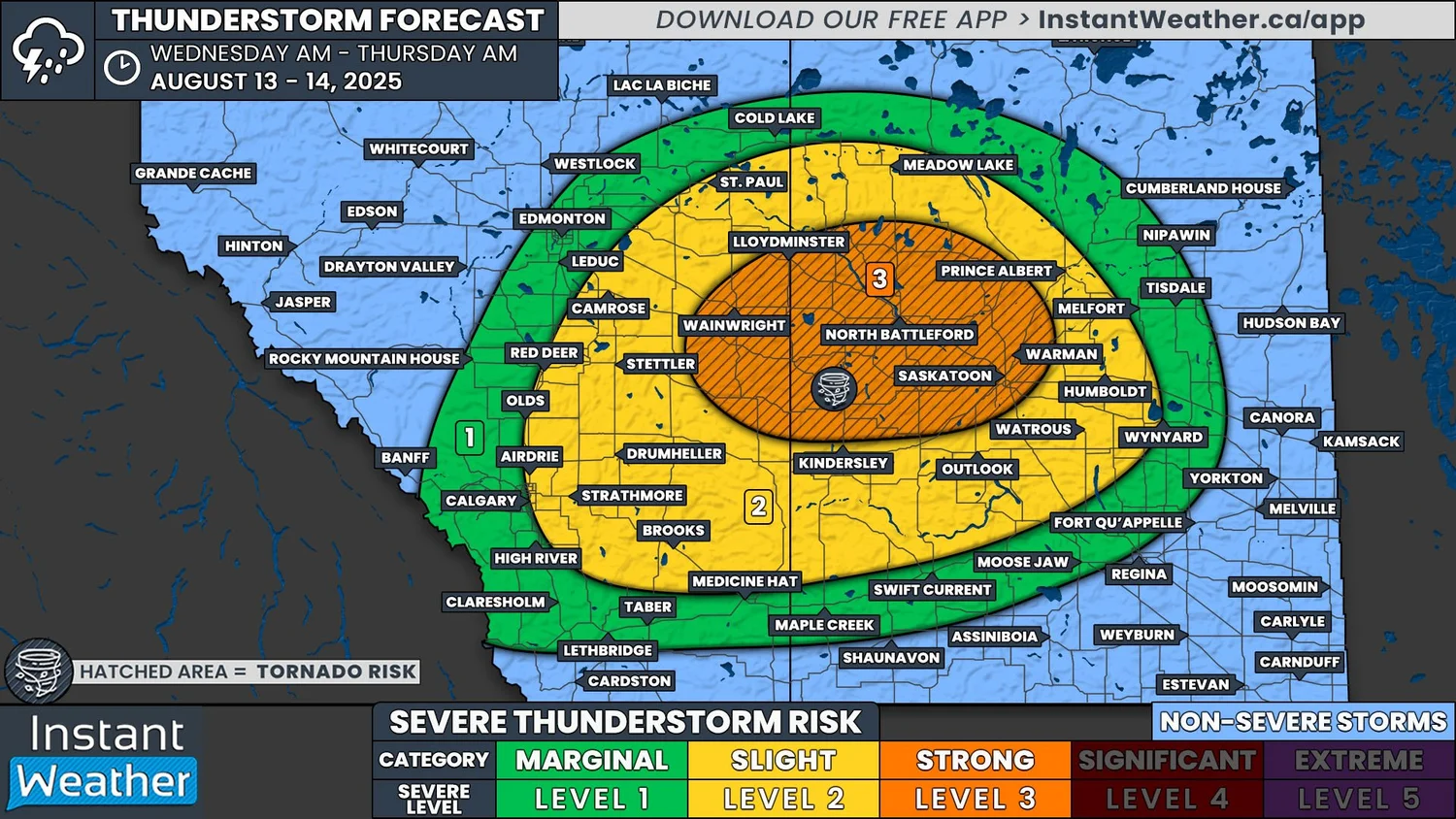
NOTE: YOU CAN CLICK ON THE MAP TO OPEN A ZOOMABLE IMAGE
There is a widespread chance for thunderstorms across Alberta and Saskatchewan today, with particularly strong storms also possible in parts of both provinces. A low pressure system has been developing in the Foothills this morning and is expected to track eastward into Saskatchewan by the mid to late afternoon. The warm and cold fronts associated with this low will be the trigger behind today’s thunderstorm development.
We’ve already begun to see some weak storms moving through parts of Central Alberta and additional isolated thunderstorms should begin to develop in the early to mid afternoon through the Foothills around Calgary and southward. Together, these storms are expected cross Alberta and into Saskatchewan through the remainder of the afternoon and evening. The thunderstorms are then anticipated to continue crossing Central Saskatchewan through the evening and into the overnight hours, before they finally begin to taper off.
Despite the storms expected to be isolated throughout the day, the risk is widespread because it has been difficult to pin down exactly where the storms will impact. There is also the possibility of some capping, which could limit thunderstorm development from even occurring.
Today’s storms, if and when they develop, could easily strengthen to become strong supercell thunderstorms, which could have the potential to produce damaging winds in excess of 100km/h, hail as large as golf balls, and heavy downpours that may lead to localized flooding. The risk of these storms stretches from Calgary to Wynard, SK, however, we have highlighted an area where the strongest of today’s storms could possible hit.
This area covers parts of East Central Alberta and West Central Saskatchewan, from Wainwright, AB to Warman, SK and including Saskatoon, and is the bullseye for the greatest severe weather threat this afternoon and evening. Severe thunderstorms that impact this region could possibly produce destructive wind gusts well in excess of 100km/h, as well as hail that could be as large as tennis balls and even heavier rain with an increased chance of flooding. This area could also end up seeing a tornado or two touch down.
We will be keeping a close eye on the situation throughout the day and we will likely be livestreaming later, once the thunderstorms have developed and strengthened.


