Post-Thanksgiving Cool Down to Bring Season’s First Flurries to Parts of Southern Ontario on Tuesday
/

NOTE: YOU CAN CLICK ON THE MAP TO OPEN A ZOOMABLE IMAGE
The chill is definitely in the air following the Thanksgiving long weekend across Ontario, with overnight lows hovering around the freezing mark in many areas over the past few days.
This is a sharp change from the mild autumn weather we experienced throughout September, which has led to a noticeable delay in the changing of the leaves. While the trees are still taking their time to show off their fall colors, other signs of the season are on the way over the next few days.
Most notably, the combination of colder air and the warm waters of the Great Lakes will create ideal conditions for lake-effect precipitation to develop off Lake Huron and Georgian Bay.
While most areas will see lake-effect rain, it could get cold enough along the higher elevations of the Dundalk Highlands, south of Georgian Bay, for some wet flurries to appear on Tuesday.
Additional precipitation is expected to move into Northeastern and Central Ontario by late Tuesday. As temperatures approach the freezing mark, some areas may see a transition to wet snow. However, significant accumulation is not expected, as the snow will likely melt almost immediately due to the warm ground, which remains above freezing.
For those who miss the milder weather, there’s no need to worry—there’s a warm-up on the way as we head into the weekend and early next week. Some areas could see daytime highs reaching the upper teens or even low twenties, which is well above the seasonal average for this time of year.


PRECIPITATION TYPE DURING THE DAY ON TUESDAY - MAP FROM WEATHERBELL
On Tuesday morning, most places will wake up to temperatures near the freezing mark, but daytime highs are expected to gradually rise into the mid to upper single digits. The higher elevations around Orangeville and Shelburne may struggle to climb above freezing, holding onto near-freezing temperatures throughout the day.
Lake-effect rain is expected to continue south of Georgian Bay throughout Tuesday, and some wet snow could mix in over the Dundalk Highlands during the day. This potential for flurries will be highly localized to the higher elevations between Owen Sound and Orangeville, while areas outside this region are likely to avoid the season’s first snowfall for now.
With temperatures hovering near or just above the freezing mark, significant accumulation is unlikely, as most of the snow will melt upon contact with the ground. However, there is a chance of a few wet, slushy centimeters in very localized areas.
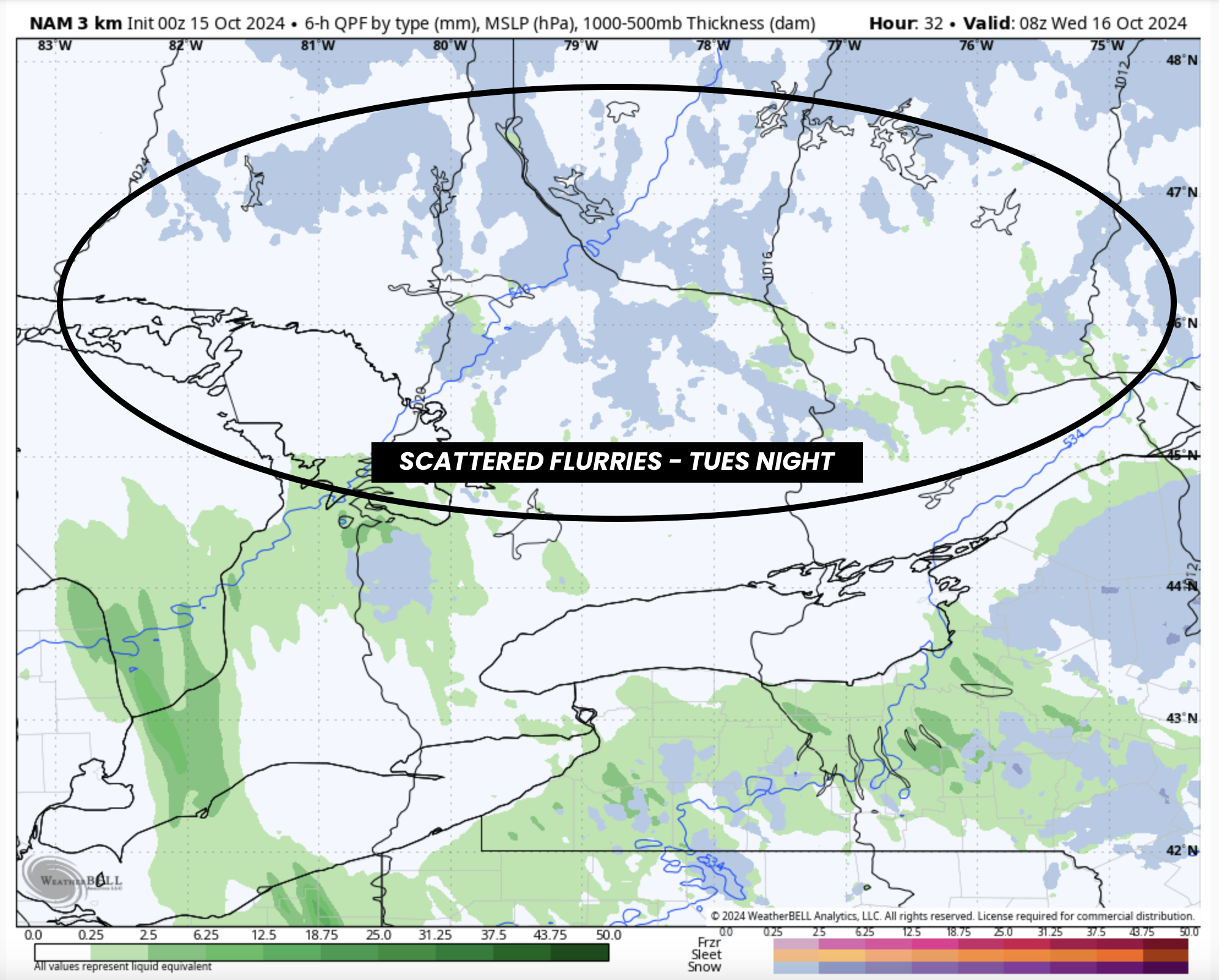
PRECIPITATION TYPE DURING TUESDAY night - MAP FROM WEATHERBELL
As we move into the evening and overnight hours, temperatures will again drop to near the freezing mark across Central, Eastern, and Northeastern Ontario. With scattered showers arriving from the north and east, there is a possibility that some of this precipitation could fall as wet flurries overnight and into early Wednesday morning.
Accumulation will remain a challenge due to the relatively warm ground. However, those in Huntsville, Algonquin Park, and the Ottawa Valley might catch a glimpse of their first snowflakes of the season. The chance of snow will diminish by late Wednesday morning as lake-effect precipitation weakens and any lingering showers move out of the region.
As mentioned earlier, we’re expecting a gradual warm-up for the rest of the week, though the mornings will still start off chilly, with temperatures in the single digits. The real warming trend will kick off on Friday, with temperatures climbing into the upper teens and possibly even approaching the low twenties in Southwestern Ontario and around the Golden Horseshoe.
This milder weather is expected to continue through the weekend and into early next week.