Southern Ontario’s Never-Ending Winter Continues This Weekend as Squalls Threaten to Bring Up to 50cm of More Snow
/
NOTE: YOU CAN CLICK ON THE MAP TO OPEN A ZOOMABLE IMAGE
With a steady parade of system after system, along with lake effect snow in between, it’s certainly understandable that some parts of Southern Ontario are getting pretty fed up with all the snow. The snow continues to pile up, especially across the snowbelt regions!
It was only a few days ago that the Barrie area was slammed with intense lake effect snow, with up to 70cm reported in the hardest hit community of Angus. And that doesn’t even include what was already on the ground before this round of squalls moved through.
Regions east of Lake Huron, including Grey, Bruce, Huron and Perth counties, have also seen their fair share of snow so far this winter, with frequent lake effect events adding to an already deep snowpack.
Fortunately for snow lovers, and perhaps unfortunately for everyone else, the squalls are far from finished. The lakes remain wide open, and we are just getting into the heart of colder Arctic air. That combination will continue to provide plenty of fuel for additional rounds of lake effect snow in the coming weeks.
The next round of squalls is just around the corner, with activity expected to ramp up again as early as Saturday morning. The good news for areas that were recently hammered by the Georgian Bay squall, including Barrie and Wasaga Beach, is that you should catch a bit of a break this weekend. The bulk of the activity will focus farther north and west.
Those east of Lake Huron, including Huron, Bruce and Grey counties, are not as lucky. Lake effect snow off Lake Huron is expected to target these areas once again with repeated rounds of snow through the weekend.
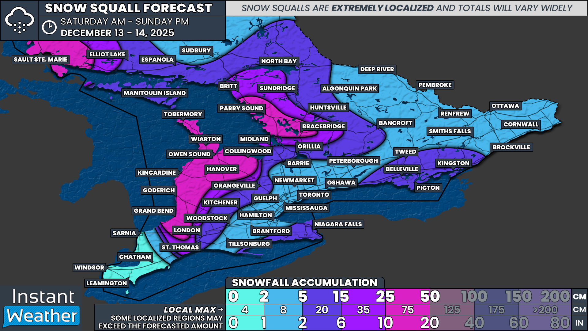
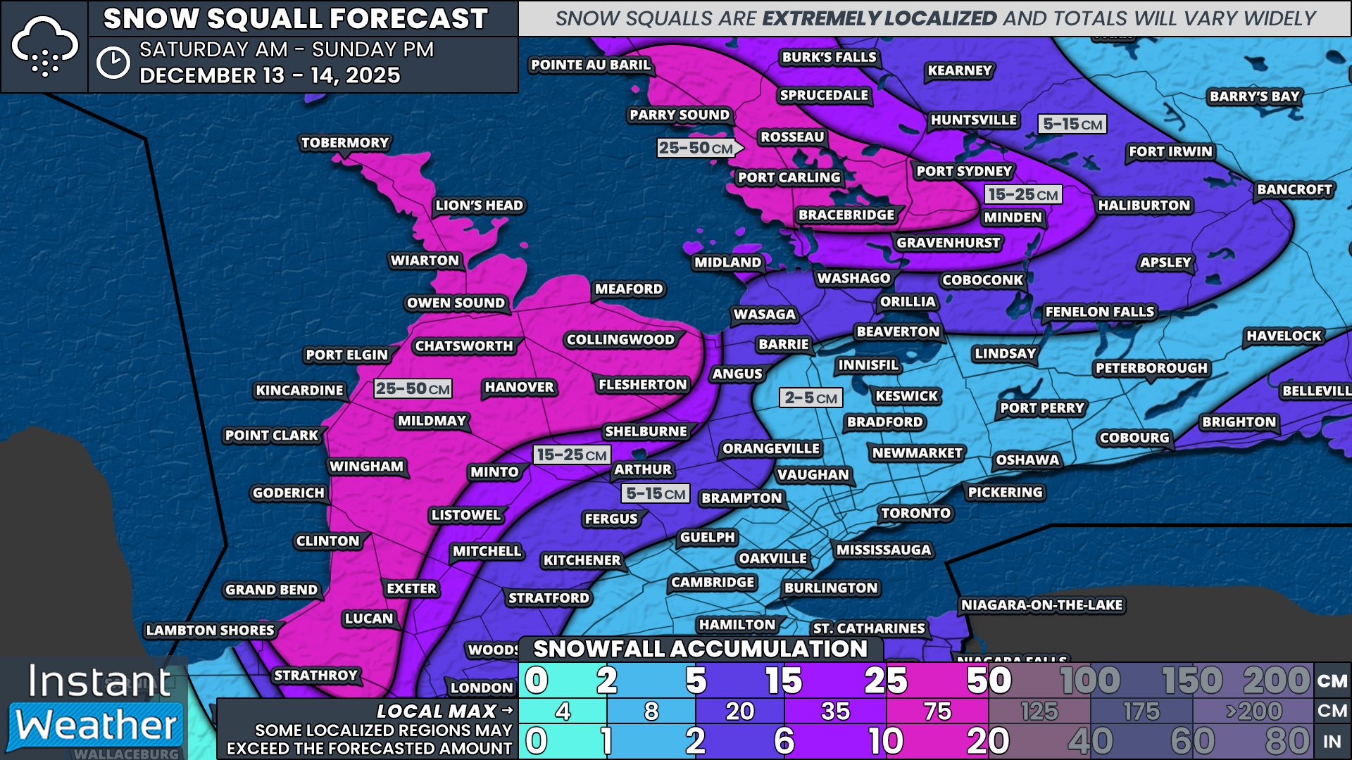
This is shaping up to be a multi-day lake effect event, with squalls persisting through the weekend and possibly into Monday. Winds are expected to be somewhat unstable, which means the squalls will tend to drift around rather than remain locked over one specific area. Because of this, it’s unlikely we’ll see extreme localized totals like the 50 to 75cm that fell southwest of Barrie earlier this week.
That said, snowfall totals will still add up. The hardest hit areas, including Parry Sound, Bracebridge, Tobermory, Owen Sound, Hanover, Collingwood, Goderich and Grand Bend, can generally expect 25 to 40cm. Some pockets, particularly across Muskoka, could push closer to the 50cm mark.
PRECIP TYPE - MAP FROM WEATHERBELL
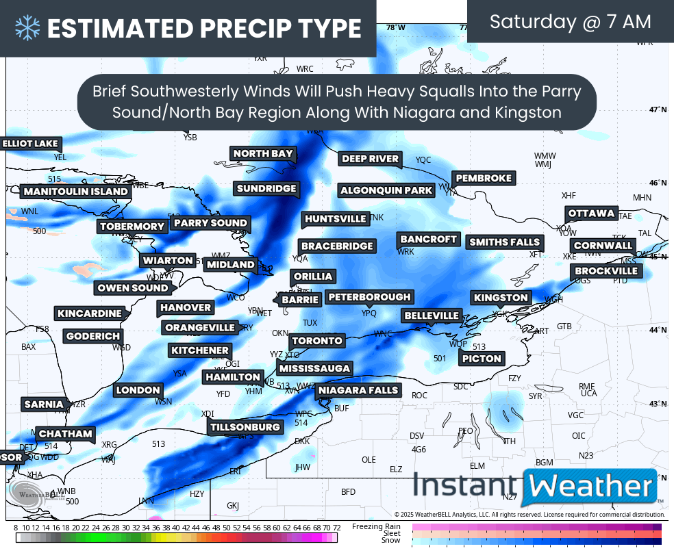
The event is expected to get underway early Saturday morning as a brief southwesterly wind develops. A weak system moving through the region will become enhanced by the lakes, producing short bursts of heavy snow.
This could impact areas northeast of Georgian Bay as well as regions northeast of Lake Erie and Lake Ontario. Places like Parry Sound, North Bay, Niagara and Kingston could see a quick 5 to 10cm early Saturday morning, along with near-zero visibility at times.
Hourly snowfall rates (cm) - MAP FROM WEATHERBELL
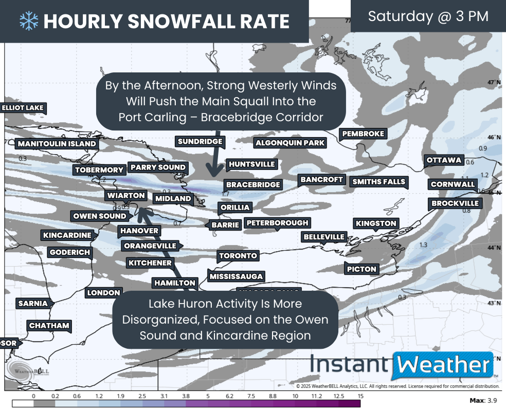
As that system exits, winds will become more westerly, shifting the focus back to Georgian Bay and Lake Huron through Saturday afternoon and evening.
Current model guidance shows a fairly potent and narrow band setting up near the northern tip of the Bruce Peninsula, stretching across Georgian Bay and coming inland near Port Carling and Bracebridge. Keep in mind that even small shifts in wind direction could push the heaviest snow several dozen kilometres north or south.
Very poor to hazardous driving conditions are expected along the Highway 400 and Highway 11 corridors in this area. Highway closures are not out of the question, especially given how quickly conditions can deteriorate.
Additionally, somewhat weaker bands are also expected to develop off Lake Huron, impacting the Owen Sound to Goderich corridor. There remains uncertainty regarding exactly where these bands will set up and whether they consolidate into a more dominant squall.

Hourly snowfall rates (cm) - MAP FROM WEATHERBELL
Later Saturday, a subtle wind shift will cause the main Georgian Bay squall affecting Muskoka to briefly drift south into Simcoe County. This could bring a short period of heavy snow overnight Saturday to Midland, Orillia and Barrie. Accumulation here should be limited, generally around 5 to 10cm, as the squall will be moving through fairly quickly.
A similar evolution will occur east of Lake Huron, with the squall drifting from Tobermory down through the Bruce Peninsula and into southern Bruce and Grey counties overnight. This activity will continue as the squall settles farther south and west of London under a more north-northwest flow.
PRECIP TYPE - MAP FROM WEATHERBELL
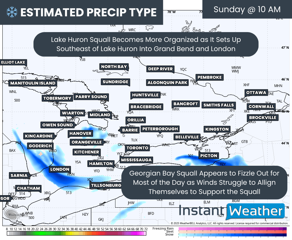
By Sunday morning, the strongest lake effect activity is expected to be found off Lake Huron, affecting the Grand Bend to London corridor. At this point, it appears the core of the squall should remain just west of London, impacting areas like Strathroy, though brief pushes into the city are still possible.
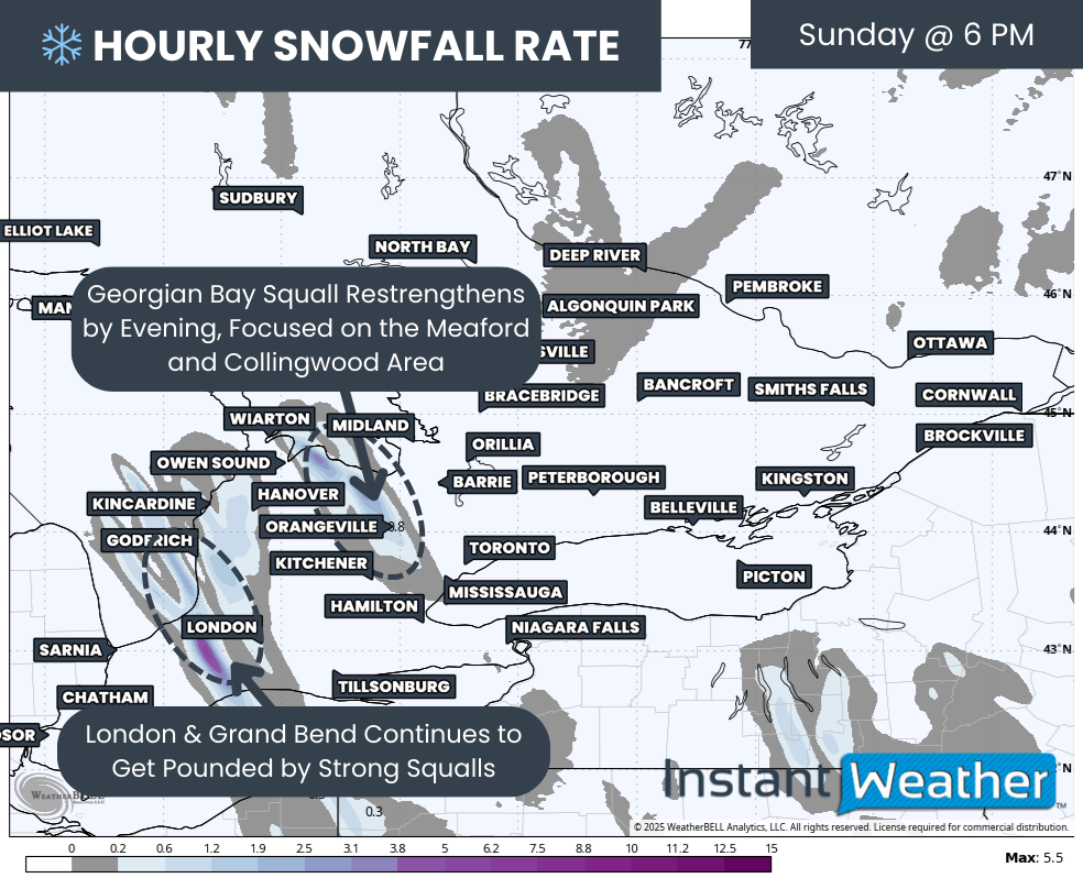
The Georgian Bay squall will temporarily weaken as winds become less favourable for a strong lake fetch. This should restrict activity mainly to shoreline areas near Meaford and Collingwood for a time.
Hourly snowfall rates (cm) - MAP FROM WEATHERBELL
That break will be short-lived. By Sunday evening, increasing winds will allow lake effect snow off Georgian Bay to intensify once again. Some models show moderate to heavy snow developing from Meaford through Collingwood and extending toward the Orangeville region overnight, before the lake effect machine is shut down by an approaching system on Monday morning.
Lake Huron squalls will continue through this time, remaining heavy at times across Huron County, Grand Bend and areas west of London. As with earlier periods, most of the heaviest snow should stay just to the west of the city.
NOTE: YOU CAN CLICK ON THE MAP TO OPEN A ZOOMABLE IMAGE
Because the squalls will be shifting around, snowfall will be more evenly distributed across a wider area. We aren’t expecting extremely high localized totals, but many communities will still share in the heavy snowfall. By the end of the weekend, most areas east of Lake Huron and Georgian Bay could see totals ranging from 25 to 50cm.
The usual lake effect disclaimer applies. Some locations will inevitably end up just outside the heaviest bands, but the contrast should be less dramatic this time since most snowbelt areas will be impacted at some point.
The main target zones include areas east of Georgian Bay, such as Parry Sound, Rosseau, Port Carling, Bracebridge and Port Sydney, along with much of Bruce, Grey, Huron and Middlesex counties east and southeast of Lake Huron. This includes communities like Tobermory, Wiarton, Lion’s Head, Owen Sound, Meaford, Collingwood, Flesherton, Hanover, Chatsworth, Port Elgin, Kincardine, Mildmay, Point Clark, Wingham, Goderich, Clinton, Exeter, Lucan, Grand Bend and Strathroy.
Snowfall totals will drop off quickly outside of these regions, as lake effect snow remains highly localized. However, as mentioned earlier, a brief 5 to 10cm is still possible Saturday morning for parts of Niagara and the Kingston area due to lake-enhanced snow from the passing system.
For the rest of Southern Ontario, expect around 2 to 5cm from that system on Saturday, with most locations likely closer to the lower end of that range outside of the snowbelt.


