‘Snow Day’ Forecast: Icy Conditions Could Give Some Students an Early Start to Holiday Break Across Southern Ontario on Friday
/
For an updated list of school bus cancellations & school closures, please visit our live article: https://instantweatherinc.com/article/2025/12/19/bus-cancellations
NOTE: YOU CAN CLICK ON THE MAP TO OPEN A ZOOMABLE IMAGE
A messy roller coaster of weather is expected across Southern Ontario throughout the day on Friday. It will begin with rain overnight, switching over to heavy snow right around the height of the morning commute. Temperatures will then plunge quickly, leading to the development of icy conditions.
To make things even more complicated, lake effect snow is expected to redevelop east of Lake Huron and Georgian Bay later in the day, with locally 10 to 20 cm of snow possible by Friday evening.
With the rain changing to snow, lining up with the morning commute and temperatures dropping through the freezing mark, there is potential for school bus cancellations, especially in rural areas.
The temperature drop is expected to be fairly gradual, which makes it uncertain whether Environment Canada will issue flash freeze warnings. That uncertainty also makes it harder to determine whether conditions will reach the threshold needed for widespread cancellations.
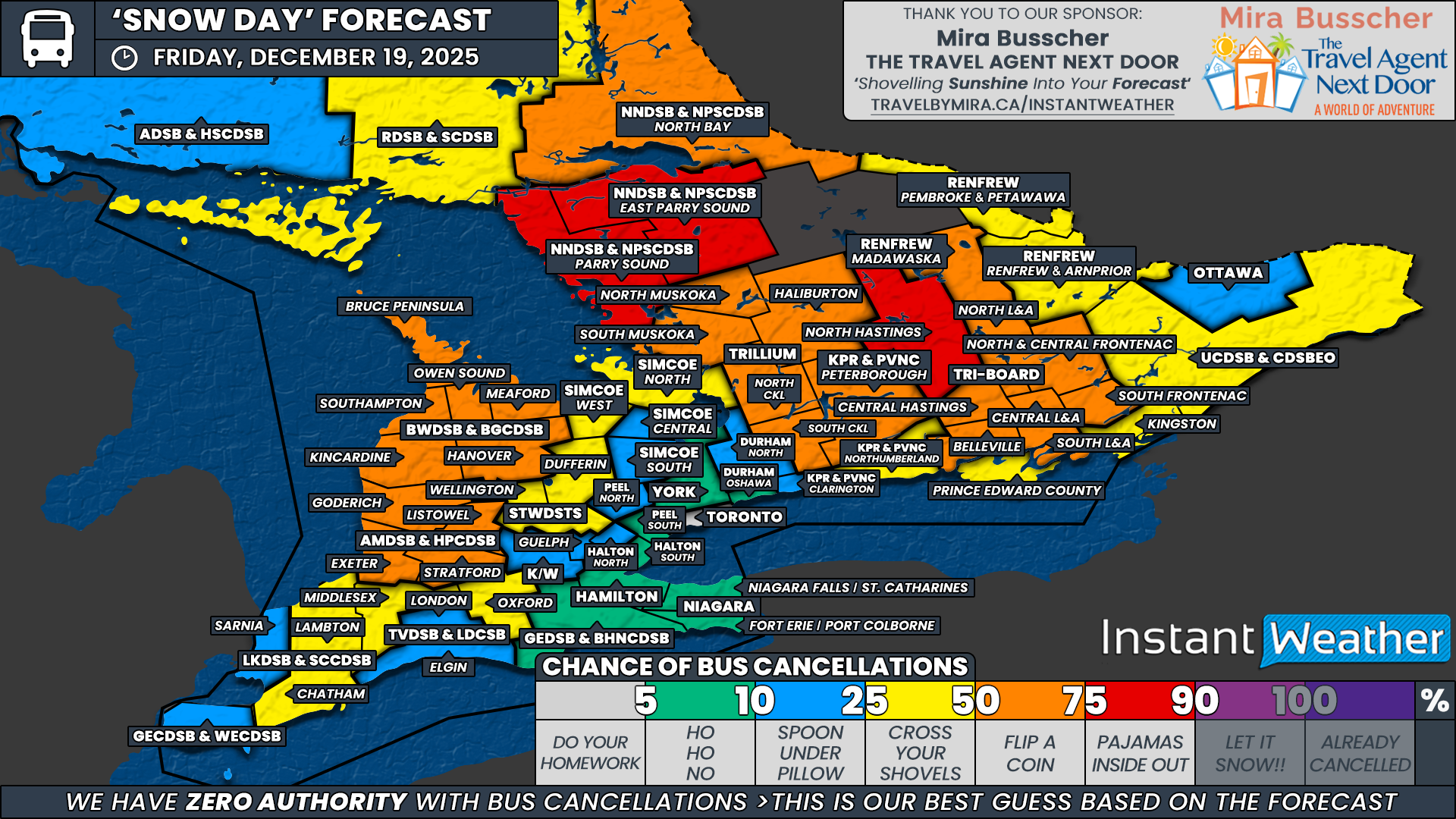
Our highest confidence lies in two regions that tend to be more sensitive to winter weather due to the large number of rural routes they serve. These include the North Hastings zone under Tri-Board Student Transportation Services and the Parry Sound and East Parry Sound regions within the Near North District School Board.
We have assigned these areas a 75 percent chance of bus cancellations. At this point, we are leaning toward cancellations, but not strongly enough to support a higher probability.
Across the broader rural portions of Central, Eastern and Southwestern Ontario, we have assigned a 50 percent chance of school bus cancellations, as conditions could easily go either way. We do expect several cancellations within this widespread zone.
This includes areas covered by the Avon Maitland District School Board, the Trillium Lakelands District School Board, North Bay under the Near North District School Board, Peterborough County within the Kawartha Pine Ridge District School Board, and much of Tri-Board Student Transportation Services. Kingston and Prince Edward County under Tri-Board sit lower at 25 percent. This zone also includes the Madawaska region within the Renfrew County District School Board.
Outside of these areas, there is still a slight chance of cancellations, although we are leaning toward buses running in most cases. As such, we have assigned a 25 percent chance to Lambton and Chatham-Kent within the Lambton Kent District School Board, Middlesex and Oxford counties under the Thames Valley District School Board, Dufferin and Wellington counties within the Upper Grand District School Board, the Simcoe West and Simcoe North weather zones, as well as the remaining portions of the Renfrew County District School Board and the Upper Canada District School Board.
For the rest of Southern Ontario, which is largely covered by more urban school boards, cancellations are unlikely. This includes Windsor under the Greater Essex County District School Board, London and Waterloo under the Thames Valley District School Board and Waterloo Region District School Board, the Greater Toronto Area including Toronto, Peel, York, Durham and Halton, the Simcoe Central and Simcoe South zones, and the Ottawa region.
Conditions in these areas are not expected to meet typical cancellation thresholds. Still, we have assigned a small 5 to 10 percent chance to account for the possibility of a few surprise decisions if icy conditions become more impactful than currently expected.
Disclaimer: Instant Weather has zero authority when it comes to bus and school closures.
It is completely up to the school boards, bus companies, local authorities, and parents to decide what is best for their children. This is our best guess based on our forecast.