‘Snow Day’ Forecast: Snow Squalls Threaten Widespread School Bus Cancellations in Southern Ontario’s Snowbelt on Thursday
/For an updated list of school bus cancellations & school closures, please visit our live article: https://instantweatherinc.com/article/2025/12/4/bus-cancellations
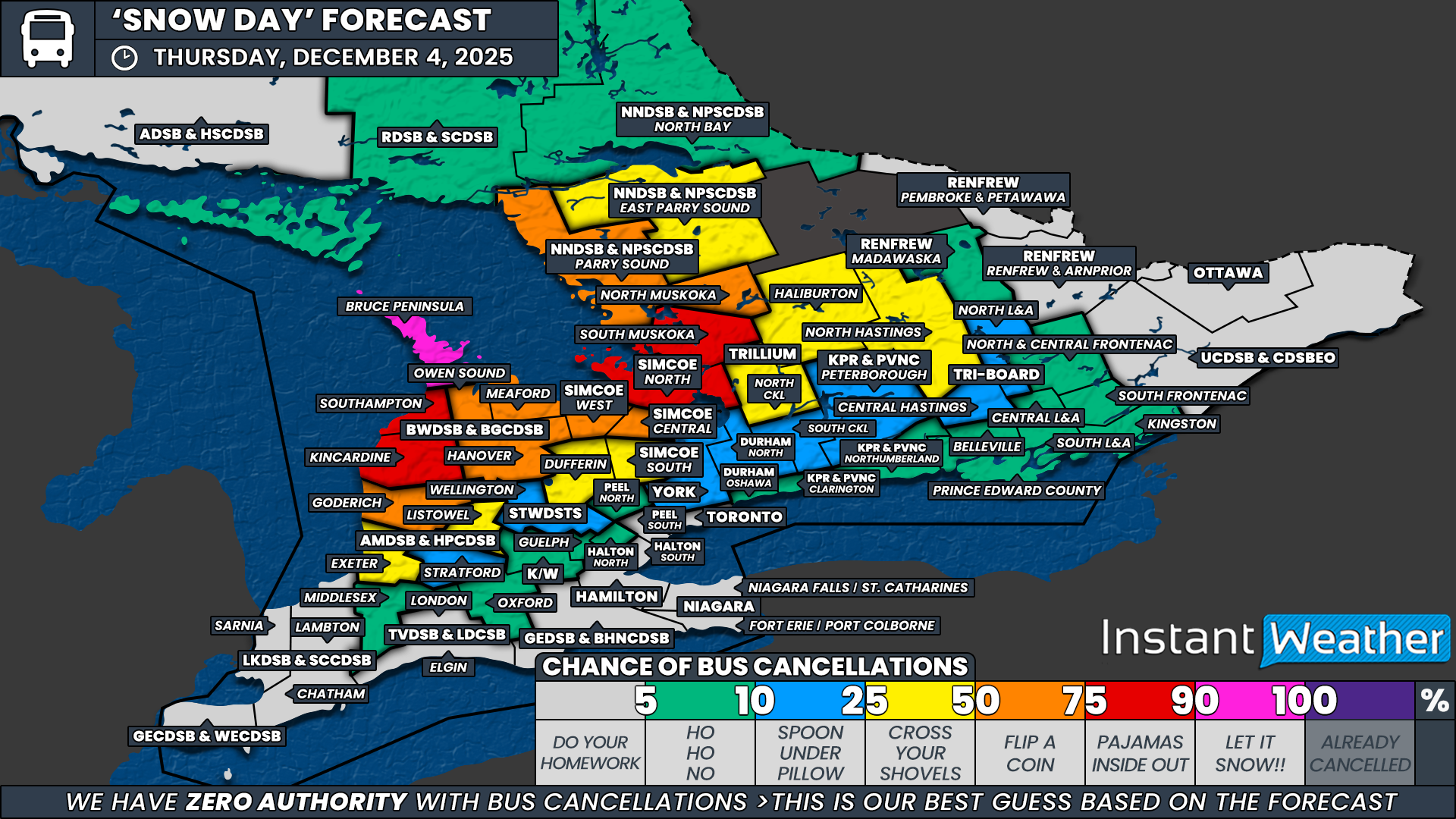
NOTE: YOU CAN CLICK ON THE MAP TO OPEN A ZOOMABLE IMAGE
Intense snow squall activity is expected to redevelop off Lake Huron and Georgian Bay overnight and into Thursday morning. These bands may produce localized whiteout conditions and rapid snowfall accumulation. Environment Canada has issued widespread snow squall watches and warnings across much of Southern Ontario in response.
Some of the alerts in place this evening are tied to a passing frontal squall, which should weaken within a few hours and is unlikely to influence the morning bus run. The greater concern comes from the more traditional lake effect squalls expected to form overnight in the snowbelt regions, where conditions can shift from manageable to hazardous very quickly.
There is still some uncertainty regarding both timing and intensity. A few forecast models keep the squalls on the weaker side until later Thursday morning. Under normal circumstances, strong warnings from Environment Canada calling for 20 to 50 cm in the most affected areas would almost guarantee cancellations. But school boards have been particularly hesitant this year, with several opting to run buses even during significant warnings. Because of this, our overall confidence is lower than it would be in a typical setup.
The Bruce Peninsula, within the Bluewater District School Board, is the clear standout in this forecast. Conditions here are expected to be hazardous early in the morning, and the path to bus cancellations is straightforward. As a result, this region is the only one assigned a 90 percent chance.
A broader zone sits in the 75 percent category, where squalls are expected to be strong enough to justify cancellations if boards respond appropriately. This includes South Muskoka within the Trillium Lakelands District School Board, the North zone of the Simcoe County District School Board, and the Kincardine and Southampton areas in Bluewater. These regions could see rapidly deteriorating conditions right around the morning commute.
Our 50 percent “toss-up” region includes North Muskoka (TLDSB), the Town of Parry Sound (Near North District School Board), the West and Central zones of the Simcoe County District School Board, the remaining portions of Bluewater, and northern Huron County within the Avon Maitland District School Board. Travel conditions here may be poor, and squalls could strengthen faster than expected, but given this year’s track record from the boards involved, confidence in cancellations is mixed.
Farther from the core impact zone, we’ve assigned a 25 percent chance to southern Huron and northern Perth counties within the Avon Maitland District School Board, Dufferin County under the Upper Grand District School Board, Simcoe South, northern Kawartha Lakes and Haliburton within TLDSB, North Hastings within Tri-Board, and East Parry Sound under the Near North District School Board. These areas either have a history of reacting to even modest weather impacts or are positioned close enough to lake effect activity to warrant a slight elevation in risk. Still, we are not expecting widespread impacts at the time decisions are made.
Elsewhere across Eastern Ontario, the Golden Horseshoe and Deep Southwestern Ontario, the chance of a snow day remains low to very low. Snow squall activity is expected to stay well to the north and west, and urban school boards in particular are essentially at zero percent for Thursday. While a few boards on the fringe of the lake effect zones have been assigned a small chance of 10 to 25 percent in case of any unexpected morning developments, widespread cancellations outside the snowbelt remain highly unlikely.
Disclaimer: Instant Weather has zero authority when it comes to bus and school closures.
It is completely up to the school boards, bus companies, local authorities, and parents to decide what is best for their children. This is our best guess based on our forecast.


