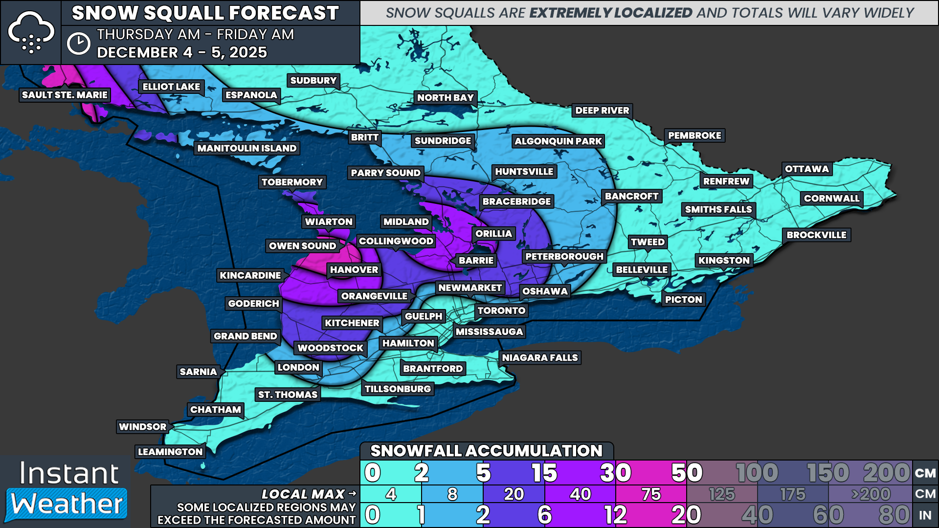
Brief, Intense Snow Squalls Return to Southern Ontario’s Snowbelt on Thursday With Up to 20 to 50cm Expected
/
NOTE: YOU CAN CLICK ON THE MAP TO OPEN A ZOOMABLE IMAGE
Intense but brief snow squalls are expected to return to parts of the snowbelt region around Lake Huron and Georgian Bay early Thursday morning with the arrival of a blast of brisk Arctic air. These squalls have the potential to bring heavy snowfall and near-zero visibility in the hardest hit areas.
Conditions are certainly ripe for more extreme, long-lasting squalls; However, the latest model data suggests this round will be cut short as shifting winds prevent the bands from locking in place for any prolonged period of time.
Snow squalls developing off Lake Huron will follow a west-northwest flow with the most intense activity aimed at the northeastern shoreline, which includes much of Grey Bruce. Another band off Georgian Bay will have a less steady flow, making the Lake Huron squall the stronger and more focused of the two.
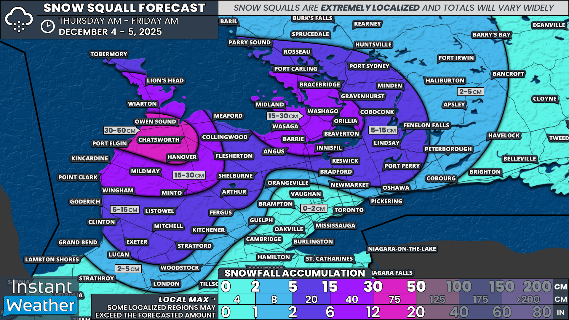
This band is expected to remain mostly stationary through much of the morning and possibly into the early afternoon before slowly weakening later in the day. Hazardous conditions are expected in this zone with complete whiteouts, blowing snow and rapid snowfall rates of 4 to 6cm per hour.
The hardest hit areas are likely to be around Port Elgin, Kincardine and Owen Sound where a band could set up early and barely move until the afternoon as winds ease and the squall dissipates. The reach of this band may stretch inland into parts of Grey County at times, including Meaford, Chatsworth, Flesherton and Hanover. Some areas could be digging out from significant totals by the end of the day.
Meanwhile, over Georgian Bay, shifting wind directions will make things much less predictable. The squall here will likely spread snowfall over a wider area rather than focusing on one region, mainly due to the flow swinging from westerly to northwesterly throughout the day.
It will likely begin with a westerly flow during the early morning, which would start the band in southern Muskoka, including MacTier, Bala, Bracebridge and Gravenhurst. It may also extend at times into southern Haliburton and northern Kawartha Lakes.
As winds turn more northwesterly, the band will slide down along the Hwy 400 and 11 corridor into northern Simcoe County, affecting Midland, Orillia and Washago. Travel in this region during the morning and early afternoon should be avoided if possible, as conditions will be quite poor.
There is still some uncertainty regarding the intensity of this Georgian Bay band, as shifting winds tend to weaken squalls and make them less organized. If it becomes even briefly stationary, that would likely be the period where snowfall intensifies.
How long the band can hold together before winds lock into a true northwest flow will determine totals for areas such as Barrie and the southern portions of Kawartha Lakes. By the early afternoon, the squall will have sunk into Wasaga, Oro and Barrie, but once the wind shift finalizes, the band will quickly lose its structure and begin to fizzle out.
If the squall lasts only into the mid-afternoon, Barrie may end up closer to 10cm. If it somehow holds into the evening, totals closer to 30cm would be possible.
All snow squall activity is expected to taper off by Thursday evening across Southern Ontario, although some light snow may linger overnight into Friday morning in areas closer to the lakes.
For Northern Ontario, snow squalls off the southeastern shoreline of Lake Superior will develop overnight and persist through much of Thursday. Sault Ste. Marie and the Wawa region may pick up 30 to 50cm by the end of the day. That lake effect activity is expected to weaken Thursday evening as a weak system shifts the wind direction.
Snowfall totals will vary widely due to ongoing uncertainty about the exact placement and duration of the bands. Confidence is highest that the Lake Huron squall will remain more focused compared to the Georgian Bay band.
As a result, the hotspot includes Port Elgin, Owen Sound, Hanover and Chatsworth, where 30 to 50cm is expected, with some models even hinting at localized pockets approaching 60cm.
The rest of Grey and Bruce counties are looking at 15 to 30cm, although totals may vary significantly depending on how far inland the squall extends and whether it drifts south into northern Huron and Perth counties.
Areas farther south and inland, including the rest of Huron and Perth counties, Wellington, Dufferin and Collingwood can expect around 5 to 15cm, but there is still a chance for much lower amounts if the band does not stretch that far.
A large zone along the Hwy 400 and 11 corridor from MacTier and Gravenhurst in the north to Barrie in the south, including Midland, Washago, Orillia and Wasaga, is expected to see the highest totals from the Georgian Bay squall.
At this point, 15 to 30cm appears likely, although localized totals up to 40cm are possible should the squall stall for any period of time. If that occurs, the most probable region for this is somewhere between Midland and Orillia.
The rest of Muskoka, Parry Sound, Haliburton, Kawartha Lakes and northern York and Durham regions can expect between 5 and 15cm, depending heavily on how far inland the Georgian Bay squall is able to stretch.
Elsewhere across Southern Ontario, less than 5cm is expected by the end of Thursday.


