💨 WINDY WEDNESDAY: Environment Canada Forecasting Severe Thunderstorms With 90km/h Wind Gusts, Toonie Sized Hail & 50mm Flooding
/Environment Canada has released its latest Thunderstorm Outlook forecasting a “moderate” (2 out of 4) risk for severe thunderstorms across much of Southern Ontario on Wednesday, June 4th, 2025. They mention the potential for 90km/h damaging wind gusts, up to toonie size hail (2-3cm) and 50mm of rainfall that could bring isolated flooding. Timing looks to be from the afternoon to the evening for the strongest storms. Additionally, they mention a “minor” risk (1 out of 4) for thunderstorm activity on Thursday. We’ll break it down below.
💨 Windy Wednesday
Wednesday Morning:
The first storms are expected to arrive overnight Tuesday into Wednesday morning. These will mainly affecting portions of northeastern Ontario. This includes areas north of Sault Ste. Marie, stretching around Timmins and Moosonee towards the Quebec border and regions north of Lake Superior. Expect non-severe thunderstorms, with the main concern being isolated lightning strikes. While widespread heavy rain isn't the primary threat here, local rainfall amounts could reach up to 30 mm, with peak hourly rates around 15 mm. Environment Canada indicates a moderate confidence level for these initial storms.
Wednesday Afternoon and Evening:
The afternoon and evening will bring a risk for severe thunderstorms across much of Southern Ontario. This area could experience isolated storms capable of producing a combination of strong winds, large hail, and heavy rain. Impacts could include damage to plants and crops, and loose objects could be tossed around by the gusty winds. There's also a risk of damage to weaker structures, broken tree branches and even downed trees. With the heavy rain, possible flash flooding and water pooling on roads are also concerns. Rainfall in these stronger storms could locally total up to 50mm, with intense peak hourly rates reaching up to 30mm. It's important to note that areas experiencing several rounds of thunderstorms have the strongest chance of seeing isolated flooding.
Interestingly, Environment Canada adds a caveat for these Southern Ontario storms: while some thunderstorms may indeed produce very gusty winds, hail, and torrential downpours, there's a possibility that smoke aloft might hinder their overall strength. This makes Environment Canada’s confidence of how severe these storms will become lower than normal for this type of setup, despite the potential for “moderate” to “high” impacts.
⛈️ Thunder Thursday
Thursday:
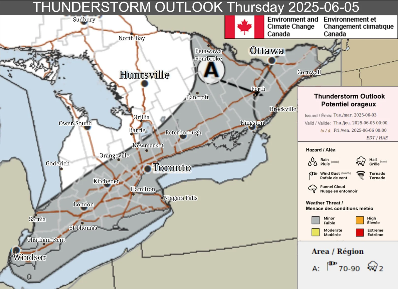
The likelihood of thunderstorms continues into Thursday across many parts of northern, far northern, and southern Ontario including areas like Windsor, London, Toronto, Hamilton, etc. Non-severe thunderstorms remain possible. Once again, isolated lightning strikes will be the main concern with local rainfall generally expected to be less than 15 mm. Environment Canada has moderate confidence in these storms developing.
The focus Thursday shifts towards Eastern Ontario, highlighted as 'Area A' on the forecast map above. This area includes Ottawa, Cornwall, Perth, Brockville and areas east of Kingston. Stronger thunderstorms are possible, bringing hazards of strong winds and hail. If these storms strengthen as expected, they could damage plants and crops and toss loose objects. Environment Canada suggests these storms could produce wind gusts from 70-90 km/h and hail up to 2 cm (nickel size). Additionally, local rainfall amounts are expected to be up to 15 mm.
🔎 Staying Safe and Prepared
As we move into summer and a more active weather pattern, it’s critical to stay informed! To keep a close eye on our latest forecasts and get notified of any alerts, download our free app Instant Weather, available on Apple and Android devices.
Remember the golden rule of lightning safety: "When thunder roars, go indoors!" as there is no safe place outside during a thunderstorm. Ahead of the storms, particularly on Wednesday afternoon and evening in Southern Ontario and throughout Thursday in Eastern Ontario, take a moment to secure any loose outdoor items before the storms arrive. Things like patio furniture, trampolines, and garbage cans can become projectiles in strong winds.
If you're planning to be on the roads, be prepared for challenging driving conditions such as sudden downpours, significantly reduced visibility, and the possibility of water pooling on roadways, especially in areas expecting heavier rainfall.
Stay safe everyone and if it’s safe to do so, share your reports with half a million community members on our Facebook group called Ontario Storm Reports!
Disclaimer: These forecasts are issued by Environment Canada and typically published via their Twitter/X accounts. We receive these forecast via a daily email and often publish them to help inform our communities.


