‘Snow Day’ Forecast: Localized School Bus Cancellations Possible on Wednesday in Parts of Southern Ontario
/While the heavier snow that impacted parts of Eastern Ontario earlier on Tuesday has begun to wind down, lingering impacts may still be felt into Wednesday morning. This will be especially true in rural areas, where secondary roads and backroads may remain snow-covered or poorly cleared by the time buses are scheduled to be on the road.
Behind this departing system, attention turns back to the lakes. Some scattered lake effect snow is expected to redevelop east of Lake Huron overnight and continue into Wednesday morning. Gusty winds, at times reaching 50 to 60 km/h, may combine with this snow to produce areas of blowing and drifting snow. This setup could lead to locally reduced visibility and difficult travel conditions through portions of Grey Bruce and extending into Huron and Perth counties.
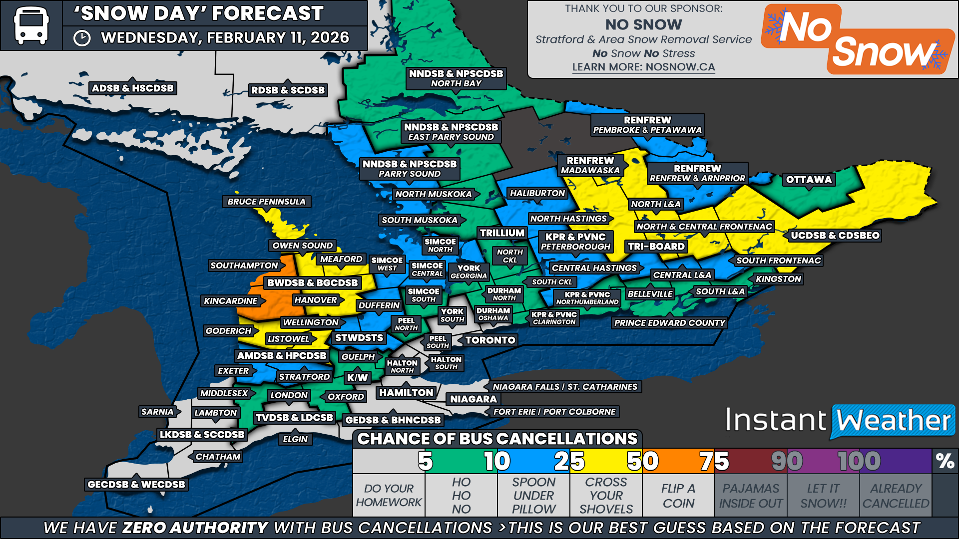
Because of this, the strongest chance for school bus cancellations on Wednesday is focused on southern Bruce County within the Bluewater District School Board. This region is most directly exposed to Lake Huron and typically sees stronger wind gusts when lake effect activity is present. Even lighter snowfall amounts can quickly become problematic here due to blowing snow on rural routes.
That said, there is still some uncertainty with this setup. Ice coverage on Lake Huron has increased substantially, which can limit how organized and intense the lake effect snow becomes. We have seen several recent events underperform, likely due to forecast models overestimating the available moisture from a partially frozen lake. Because of this uncertainty, and with no active Environment Canada alerts currently in place, we have capped the probability at 50 percent for southern Bruce County, as it could genuinely go either way.
A slight chance, around 25 percent, has been assigned to the remainder of the Bluewater District School Board, as well as northern sections of Huron and Perth counties, under the Avon Maitland District School Board. In these areas, significant new snowfall is not expected. However, strong winds could still lead to localized blowing and drifting snow, which may be enough to prompt a few cancellations, particularly on exposed rural routes.
We have also extended a 25 percent chance into parts of rural Eastern Ontario. This includes areas covered by the Upper Canada District School Board, North and Central Frontenac, North Lennox and Addington, and North Hastings under Tri-Board Student Transportation Services, as well as the Madawaska region under the Renfrew County District School Board.
While active snowfall should be over by Wednesday morning in these regions, experience has shown that backroads can take longer to fully clear when snow tapers off the evening before. That lingering cleanup concern keeps a few of these boards in play for isolated cancellations.
Outside of these areas, the probability drops off quickly. A widespread low to very low chance has been assigned across adjacent school boards through Central Ontario and into the rest of Eastern Ontario.
While the odd surprise cancellation cannot be completely ruled out based on local road conditions, we are not expecting any widespread issues, and most school boards should see a normal return to classes on Wednesday.
Across Deep Southwestern Ontario, along the Lake Erie shoreline and throughout the Golden Horseshoe, school bus cancellations are not expected. Conditions in these regions should remain manageable, with no significant snowfall or blowing snow anticipated overnight or into the morning.
Disclaimer: Instant Weather has zero authority when it comes to bus and school closures.
It is completely up to the school boards, bus companies, local authorities, and parents to decide what is best for their children. This is our best guess based on our forecast.


