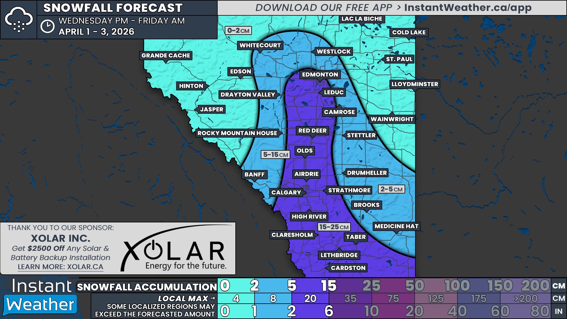
Southern Ontario: ‘Snow (Fog/Ice) Day’ Forecast for Wednesday, March 4, 2026
/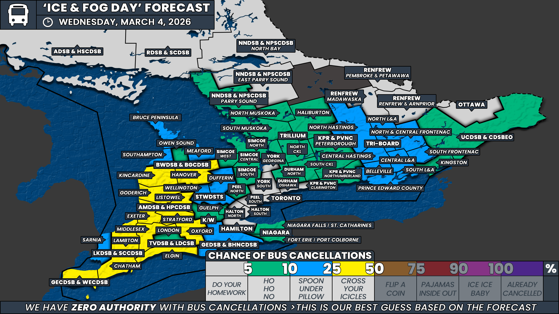
NOTE: YOU CAN CLICK ON THE MAP TO OPEN A ZOOMABLE IMAGE
Localized patches of thick fog are expected to develop across parts of Southern Ontario late Tuesday night and persist into Wednesday morning. In some areas, this fog could become quite dense, reducing visibility significantly during the early morning hours when school transportation decisions are typically made.
Adding to the concern is the potential for temperatures to hover near the freezing mark overnight. Where this occurs, freezing fog may develop, allowing tiny droplets of moisture to freeze on contact with cold surfaces. This can lead to a light glaze of ice forming on untreated roads, sidewalks, and rural backroads.
Because of the combination of reduced visibility and the possibility of icy patches, there is a chance that some school boards may opt to cancel buses or implement delayed starts on Wednesday morning. However, forecasting fog-related cancellations is notoriously difficult because fog can be extremely localized. One community may experience dense fog while a nearby town remains completely clear.
For that reason, no single region stands out as having a guaranteed chance of cancellations. Instead, the forecast leans toward scattered and localized decisions depending on where the fog becomes thickest and whether freezing fog creates slick road conditions.
As a result, the highest probability we are assigning anywhere in the region is a 25 percent chance.
This widespread 25 percent zone includes areas under the Greater Essex County District School Board, Chatham-Kent and Lambton County under the Lambton Kent District School Board, Middlesex, Oxford and Elgin counties under the Thames Valley District School Board, all regions within the Avon Maitland District School Board, and the southern portion of the Bluewater District School Board.
These areas are expected to see the most widespread fog development overnight and into early Wednesday morning. Many of these boards also cover large rural transportation zones where dense fog has historically prompted cancellations or delays due to safety concerns for bus drivers.
Outside of these regions, a broader low to very low chance extends across the remainder of Southwestern Ontario and into parts of Central Ontario. In these areas, patchy fog or localized freezing drizzle may still develop, potentially leading to isolated slick spots on untreated roads. However, confidence in widespread impacts is low, so these regions have been assigned only around a 5-10 percent chance of cancellations.
Across the Golden Horseshoe and the Ottawa Valley, conditions are expected to remain largely manageable. Urban school boards in these regions tend to have a much higher threshold for weather-related cancellations, and current forecasts do not suggest visibility or icing conditions will reach that level.
Because of this, bus cancellations are not expected across the Greater Toronto Area, Hamilton area, or Ottawa on Wednesday morning.
Disclaimer: Instant Weather has zero authority when it comes to bus and school closures.
It is completely up to the school boards, bus companies, local authorities, and parents to decide what is best for their children. This is our best guess based on our forecast.