‘Snow/Ice Day’ Forecast: Widespread Bus Cancellations and School Closures Likely Wednesday for Ottawa, Eastern and Central Ontario Due to Significant Ice Storm
/For an updated list of school bus cancellations & school closures, please visit our live article: https://instantweatherinc.com/article/2026/3/11/bus-cancellations

Enter to Win a 7-Night Cruise for 2 with Celebrity Cruises, Including Airfare - Select Patricia Bootsma as your travel consultant
NOTE: YOU CAN CLICK ON THE MAP TO OPEN A ZOOMABLE IMAGE
A high-impact freezing rain event is expected to develop overnight Tuesday and continue throughout Wednesday across parts of Central and Eastern Ontario. This system has the potential to produce significant icing, which could lead to dangerous travel conditions and widespread disruptions.
Environment Canada has already issued strongly worded freezing rain warnings across the region. These alerts mention the potential for 10 to 20 millimetres of ice accretion, which is enough to cause significant travel hazards and possibly widespread power outages. With freezing rain expected to be ongoing during the morning commute, it is highly likely that many school boards in the affected regions will keep buses off the roads. In some cases, full school closures are also possible.
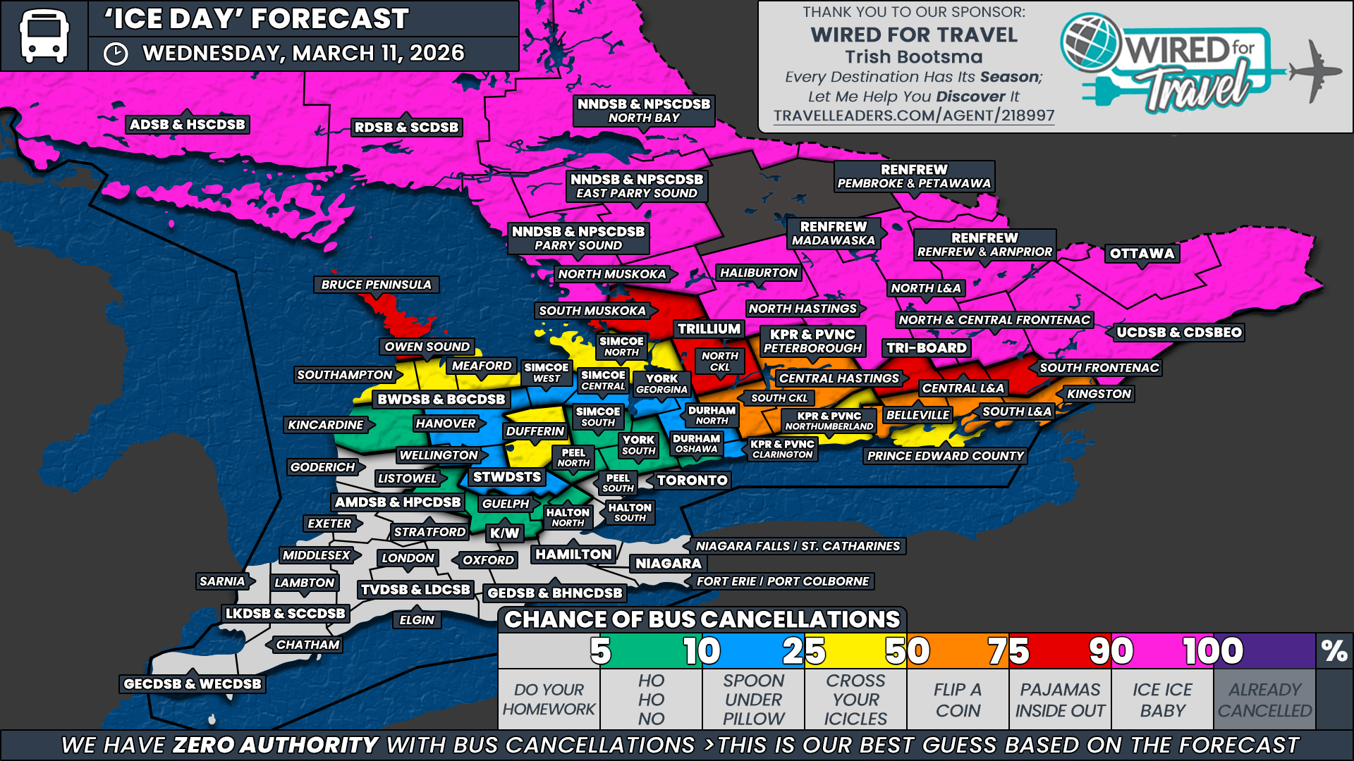
The hardest hit areas are expected to be across Eastern Ontario and Northeastern Ontario. These regions are currently under the core of the freezing rain and winter storm warnings and are forecast to see the longest duration of icing. Because of this, we have assigned a 90 percent chance of school bus cancellations to these regions.
This includes areas covered by the Ottawa Carleton District School Board, the Upper Canada District School Board, the Renfrew County District School Board, North and Central Frontenac, North Lennox and Addington, and North Hastings under Tri Board Student Transportation Services, Haliburton and North Muskoka under the Trillium Lakelands District School Board, the Near North District School Board, the Rainbow District School Board, and the Algoma District School Board. With heavy freezing rain expected during the morning bus run, it is difficult to see how buses could operate safely in these areas.
Moving west and south, the probability begins to drop fairly quickly as the expected duration of freezing rain decreases. However, because of the timing of the system, even a few hours of icing during the early morning could be enough to trigger cancellations in some regions.
For that reason, we have assigned a strong 75 percent chance of cancellations to the Bruce Peninsula under the Bluewater District School Board, South Muskoka and North Kawartha Lakes under the Trillium Lakelands District School Board, and Central Hastings, Central Lennox and Addington, and South Frontenac under Tri Board Student Transportation Services. These regions are very likely to see cancellations, although there is still a possibility that some boards may attempt to run buses if temperatures warm more quickly than expected in the southern portions of these areas.
In the toss-up category with a 50 percent probability, we have included South Kawartha Lakes under the Trillium Lakelands District School Board, Peterborough County under the Kawartha Pine Ridge District School Board, and Belleville, South Lennox and Addington, and Kingston under Tri Board Student Transportation Services. These regions are expected to see lighter icing compared to areas farther north, and the outcome could depend heavily on how quickly temperatures rise above freezing during the morning hours.
A slight 25 percent chance has been assigned to several areas that sit on the edge of the freezing rain zone. This includes Southampton, Owen Sound and Meaford under the Bluewater District School Board, Dufferin County under the Upper Grand District School Board, the Simcoe North weather zone under the Simcoe County District School Board, Northumberland County under the Kawartha Pine Ridge District School Board, and Prince Edward County under Tri Board Student Transportation Services.
In these regions, cancellations are less likely. However, if cold air remains entrenched longer than expected, even a short period of freezing rain could leave untreated roads slick enough to create travel concerns, especially for higher elevations.
In the case of Northumberland County and Prince Edward County, significant icing is not currently expected. However, their proximity to the hardest hit regions means there is still the possibility of system-wide transportation decisions that could result in an ice day even if local conditions are not as severe.
A low to very low chance of cancellations extends into the northern portions of the Greater Toronto Area and around Lake Simcoe. These areas may briefly see a period of freezing rain, especially in higher elevations, but the event is expected to transition to rain quickly enough that cancellations are unlikely.
Across Southwestern Ontario and much of the Golden Horseshoe, this storm is expected to bring mainly rain rather than freezing rain. Because of this, no school bus cancellations are expected in those regions.
Disclaimer: Instant Weather has zero authority when it comes to bus and school closures.
It is completely up to the school boards, bus companies, local authorities, and parents to decide what is best for their children. This is our best guess based on our forecast.


