Large Hail and Isolated Tornado Risk on Tuesday for Southwestern Ontario and Golden Horseshoe With Widespread Severe Storm Threat
/
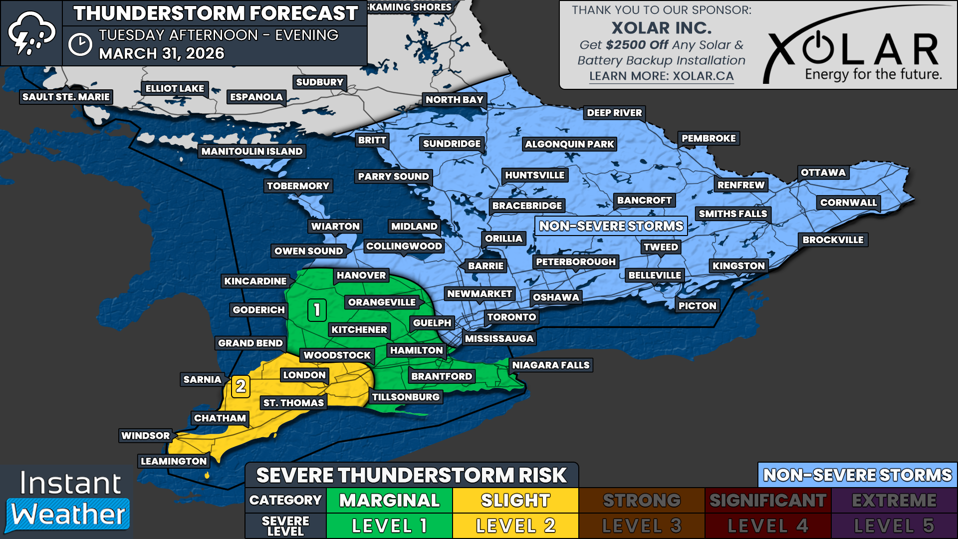
NOTE: YOU CAN CLICK ON THE MAP TO OPEN A ZOOMABLE IMAGE
Southern Ontario faces the first widespread severe weather threat of 2026 on Tuesday, which is already underway as overnight storms carrying a flooding and hail risk developed around midnight.
While the severe risk overnight is fairly limited, it could still be quite a noisy night across Southwestern Ontario and into the Golden Horseshoe.
The main risk on Tuesday is expected to take shape Tuesday afternoon and continue into the evening. A complex of storms is set to develop by early afternoon over Michigan and gradually slide into Southwestern Ontario through the afternoon.
Ahead of this line, rising temperatures reaching into the 20s in some areas of Southwestern Ontario will provide sufficient heating to fuel increasing intensity as the line builds to the southwest.
The strongest storm environment appears to be focused on Deep Southwestern Ontario such as Windsor, Chatham, Sarnia and the London region. This is where we could see more isolated storm development rather than the more linear development to the north. As such, we have gone with a slight severe risk.
That may allow for a few rotating storms, and therefore an isolated tornado can’t be ruled out. It’s certainly not the main risk though.
The primary threat is large hail that could approach Timbit size, along with isolated wind gusts of 90 to 100 km/h.
There is a marginal severe risk for areas east of Lake Huron and up to the Niagara Escarpment where there will be a sharp cut off in temperature. This will lead to storms quickly fizzling out as they lose access to the heat that was fueling them.
This includes Goderich, Kincardine, Hanover, Orangeville, Kitchener, Guelph, Hamilton, Brantford and the Niagara region.
For the rest of Southern Ontario, non severe thunderstorms are expected through the afternoon and evening across Central and Eastern Ontario, but they will be on the weaker side due to temperatures remaining in the single digits. Small hail could still be a threat, with the colder air making it possible for weaker updrafts to sustain larger than usual hail.
Another round of storms may impact Deep Southwestern Ontario during the late evening, but it is questionable how strong they will be because they will be occurring after sunset and the storms will lose access to daylight heating.
All storm risk should diminish in all areas by midnight as colder air ushers temperatures back into the single digits for Wednesday.


