Powerful June Storm System Could Bring Damaging Winds and Isolated Tornadoes to Southern Ontario Overnight
/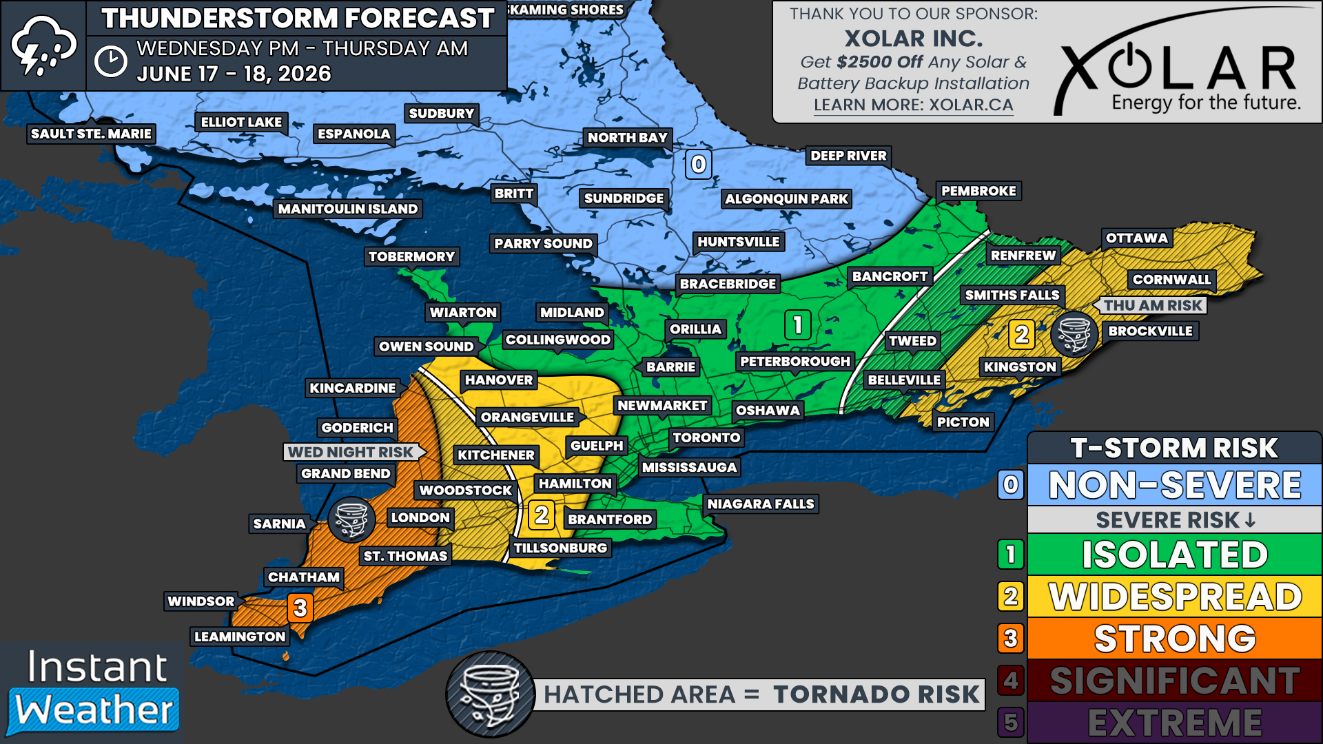
NOTE: YOU CAN CLICK ON THE MAP TO OPEN A ZOOMABLE IMAGE
An unusually strong and deepening low pressure system for mid-June is set to track through the Great Lakes region overnight Wednesday and into Thursday. This powerful system will bring the potential for severe weather to a large portion of Southern Ontario, with the greatest threat occurring late tonight and into Thursday morning.
The same system is expected to produce a significant severe weather outbreak across portions of Illinois, Indiana and Michigan this afternoon and evening. In those areas, forecasters are highlighting the risk of violent tornadoes, destructive wind gusts and large hail as a potent combination of instability and wind shear develops ahead of the approaching low pressure system.
As this line of storms pushes eastward into Michigan tonight, it is expected to gradually weaken before reaching Ontario. However, weakening does not necessarily mean the severe threat will disappear.
Even in a decaying state, this line of storms could still bring impactful weather to portions of Southwestern Ontario, especially areas closest to the international border and along the Lake Huron shoreline.
Based on the latest forecast data, the primary threat appears to be damaging wind gusts in excess of 100 km/h. In localized areas, stronger wind gusts could occur if isolated downbursts develop within the line of storms. These stronger pockets of wind have the potential to cause tree damage, power outages and scattered property damage.
While the tornado threat will be considerably lower than what is expected across parts of the United States, it cannot be completely ruled out.
The atmosphere over Deep Southwestern Ontario will remain supportive of some rotation early in the night, particularly while the line of storms is still relatively organized. Any tornado risk would likely be brief and localized in nature, but the strong dynamics associated with this system mean it is something we will be watching closely.
Another factor adding complexity to this forecast is the strength of the low pressure system itself.
In addition to thunderstorm-related winds, very strong winds will be present just above the surface overnight. Normally, a temperature inversion would act as a lid and prevent those stronger winds from mixing down to ground level. Current indications suggest that inversion should remain in place for much of the night.
However, if portions of that stronger wind are able to reach the surface, isolated non-thunderstorm wind gusts in excess of 90 km/h would be possible. This risk appears highest near the shorelines of Lake Huron and Lake Erie where local effects can help enhance wind gusts.
We’ll be closely monitoring this severe weather threat throughout the evening and overnight hours.
If conditions warrant, we’ll be going live on our YouTube channel with real-time storm tracking, radar analysis, warning updates and coverage of any severe weather that develops across Southern Ontario.
Be sure to subscribe to our YouTube channel HERE and turn on notifications so you don’t miss any live coverage. Whether it’s damaging winds, tornado warnings or rapidly changing conditions, we’ll be there to keep you informed every step of the way.
Heavy rainfall will also accompany this system. Many areas will receive beneficial rainfall, but localized torrential downpours could lead to rainfall amounts exceeding 50 mm in a relatively short period of time. If storms repeatedly move over the same area, flash flooding could develop, especially in urban locations and areas with poor drainage.
The highest severe weather risk tonight stretches across Deep Southwestern Ontario and portions of the Lake Huron shoreline. This includes Windsor, Leamington, Chatham, Sarnia, Grand Bend, Goderich and Kincardine.
In these areas, storms could begin arriving as early as 8 to 9 PM and continue through the overnight hours. Damaging wind gusts remain the primary concern, although heavy rain and an isolated tornado cannot be ruled out.
As the line progresses eastward, it is expected to reach the London, Woodstock, Kitchener, Guelph, Orangeville and Hanover areas around or shortly after midnight. There remains some uncertainty regarding exactly how much strength the storms will retain by this point. However, the potential still exists for several pockets of damaging winds to survive farther inland.
The tornado threat should be lower compared to areas farther west, but strong winds and localized flooding will continue to be concerns as the line moves through.
By the time the storms reach Central Ontario and the Golden Horseshoe during the overnight hours, the severe threat should be decreasing further. That said, this remains a powerful weather system and some stronger portions of the line could still produce isolated wind gusts approaching 90 km/h.
As a result, we continue to highlight an isolated severe weather risk for Toronto, Hamilton, Niagara, Newmarket, Barrie, Orillia, Bracebridge, Peterborough and Bancroft.
Attention will then shift to Eastern Ontario during the early morning hours on Thursday. Unlike areas farther west, there are indications that the atmosphere may begin to recover somewhat as the main line approaches. There is also the potential for additional isolated thunderstorms to develop behind or ahead of the main line shortly after sunrise.
This could allow for a secondary severe weather threat across portions of Eastern Ontario, particularly near the international border and into the Ottawa Valley. This broader morning severe weather risk includes Kingston, Brockville, Smiths Falls, Cornwall, Ottawa and Picton.
Should additional storms develop within this environment, all severe weather hazards would be possible including damaging wind gusts, heavy rainfall, hail and even an isolated tornado.
Forecast confidence in the tornado threat remains lower due to the early morning timing and questions surrounding how much instability can develop. However, the environment bears watching closely given the strength of the overall weather system.
The severe weather threat is expected to gradually come to an end from west to east through Thursday morning, with most areas seeing the risk diminish by early afternoon.
Even after thunderstorms exit the region, conditions will remain quite blustery throughout the day. Strong non-thunderstorm wind gusts may continue across much of Southern Ontario as the powerful low pressure system pulls away from the Great Lakes.


