Strong Severe Storm Risk Threatens Canada Day Across Southern Ontario, Damaging Winds and Isolated Tornadoes Possible
/
NOTE: YOU CAN CLICK ON THE MAP TO OPEN A ZOOMABLE IMAGE
Hot and humid weather has arrived across Southern Ontario just in time for Canada Day, with temperatures soaring into the mid-to-upper 30s, with the humidex making it feel into the 40s. While many will be heading outside to celebrate, this intense heat is also creating an atmosphere that is primed for severe thunderstorms later today.
Unfortunately, this stormy weather could put a damper on Canada Day celebrations, particularly across portions of Southwestern, Central and Eastern Ontario.
We are tracking a conditional severe weather threat for Wednesday afternoon and evening, with the risk potentially continuing into the overnight hours. The hot, humid air will provide plenty of fuel for thunderstorm development. Wherever storms are able to form, they could rapidly become severe thanks to the extremely unstable atmosphere.
In addition to isolated storm development, there is also the potential for one or more organized linear complexes of thunderstorms to move through Southern Ontario. If these systems develop and hold together, they could produce widespread damaging wind gusts across a large portion of the province.
We continue to describe today's threat as conditional because forecast models are doing a poor job of determining exactly where storms will develop. We know the environment is more than capable of supporting severe thunderstorms, but storms first need to form in order to take advantage of the available instability.
Development may be triggered by lake breeze boundaries, leftover outflow boundaries from earlier storms, or other small-scale features that are notoriously difficult to predict ahead of time. As a result, not everyone will see a thunderstorm today, but those that do could experience very intense conditions.
Join Us on YouTube for Storm Coverage:
We'll be providing comprehensive live coverage of any storms that develop today on our YouTube channel. Our team will be tracking storms in real time with live radar analysis, warnings, storm reports and chaser coverage, so if severe weather threatens your area, be sure to join us live to help stay informed.
As of 1 PM, we're already watching a strong complex of thunderstorms developing over Northern Michigan that is tracking toward Lake Huron and eventually Southwestern Ontario by the mid to late afternoon. If this complex is able to maintain its strength as it crosses into Ontario, it could produce widespread damaging wind gusts from areas east of Lake Huron through the Lake Simcoe region and eventually into Eastern Ontario.
Additional thunderstorms may also develop later today across Quebec before sweeping into portions of Eastern Ontario and the Ottawa Valley during the evening and early overnight hours.
Outside of these organized storm complexes, isolated thunderstorms may develop almost anywhere across Southern Ontario this afternoon and evening. If they are able to establish themselves before merging into larger clusters, a few discrete supercells could develop.
These storms would be capable of producing damaging wind gusts, hail up to the size of Timbits and an isolated tornado. While the tornado threat appears highest across Eastern Ontario, an isolated tornado cannot be ruled out anywhere in Southern Ontario today.
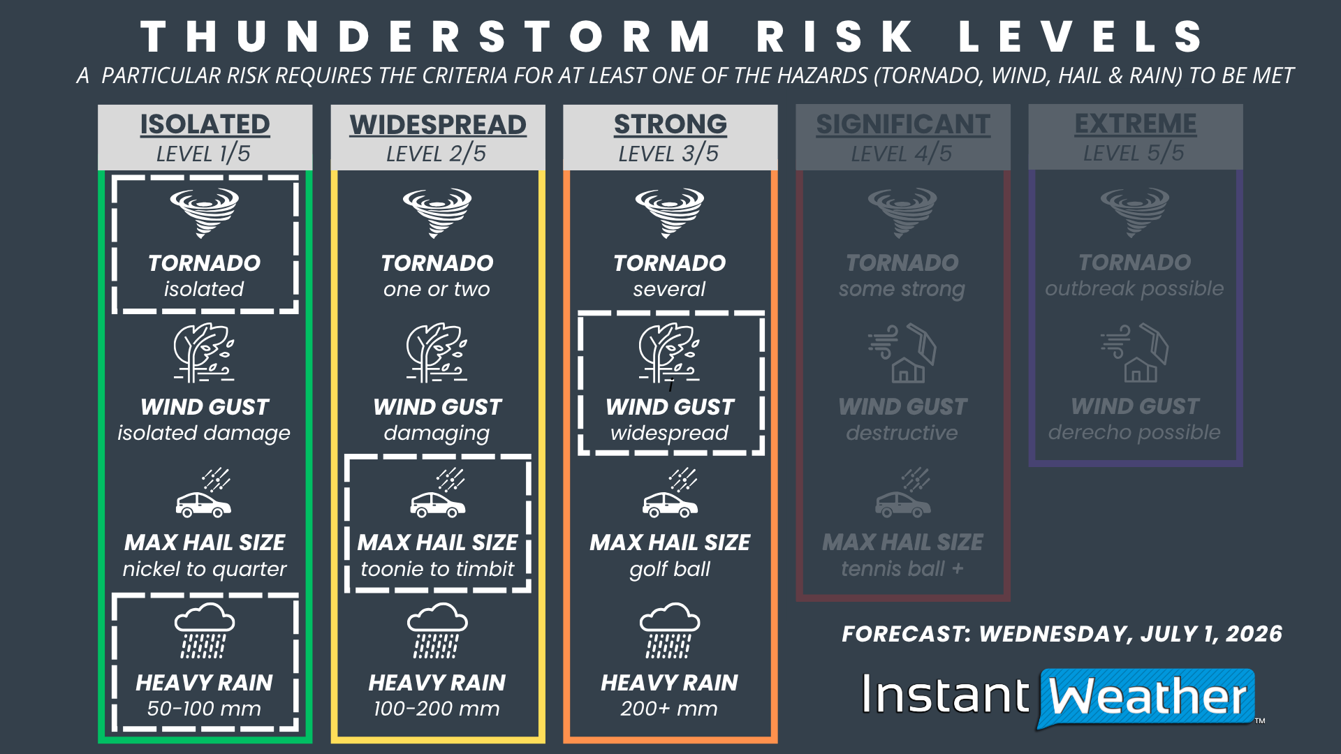
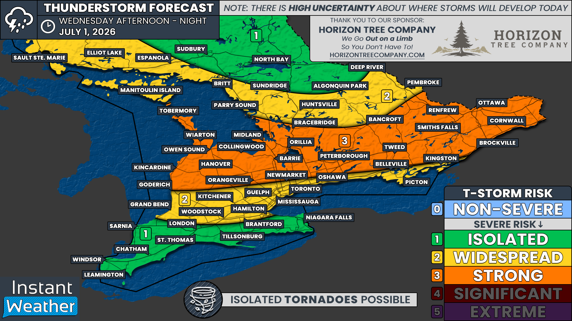
NOTE: YOU CAN CLICK ON THE GRAPHIC TO OPEN A ZOOMABLE IMAGE

We have a 'Strong' (Level 3/5) severe weather risk for locations including Goderich, Kincardine, Owen Sound, Hanover, Collingwood, Midland, Barrie, Orillia, Bracebridge, Peterborough, Tweed, Bancroft, Smiths Falls, Renfrew, Ottawa, Brockville and Cornwall. This higher risk is primarily driven by the potential for widespread damaging wind gusts this afternoon and evening, although large hail and an isolated tornado are also possible.
Surrounding areas, including Grand Bend, Woodstock, Kitchener, Guelph, Hamilton, Toronto, Newmarket, Oshawa and Kingston, are under a 'Widespread' (Level 2/5) severe weather risk. These locations could also experience damaging wind gusts if storm complexes hold together, although the tornado risk is somewhat lower compared to Central and Eastern Ontario.
We also have an 'Isolated' (Level 1/5) severe weather risk across the rest of Deep Southwestern Ontario, along with the Niagara region. While storm coverage is expected to remain limited here, any storm that does develop could quickly become severe given the highly unstable environment.
Farther north, we have gone with an 'Widespread' (Level 2/5) to 'Isolated' (Level 1/5) severe weather risk across northern portions of Central Ontario, including North Bay and Sudbury. Storms that develop in this region could strengthen before tracking south and eastward into Quebec and Eastern Ontario.
The severe weather threat should gradually diminish around midnight. However, thunderstorms may continue overnight as the atmosphere will remain exceptionally unstable despite the loss of daytime heating. If a mature storm complex is able to move through overnight, isolated severe weather will remain possible, with damaging wind gusts posing the primary threat.