


Confidence Grows in Significant Tornado, Destructive Wind and Huge Hail Threat for Southern Ontario Wednesday
/
NOTE: YOU CAN CLICK ON THE MAP TO OPEN A ZOOMABLE IMAGE

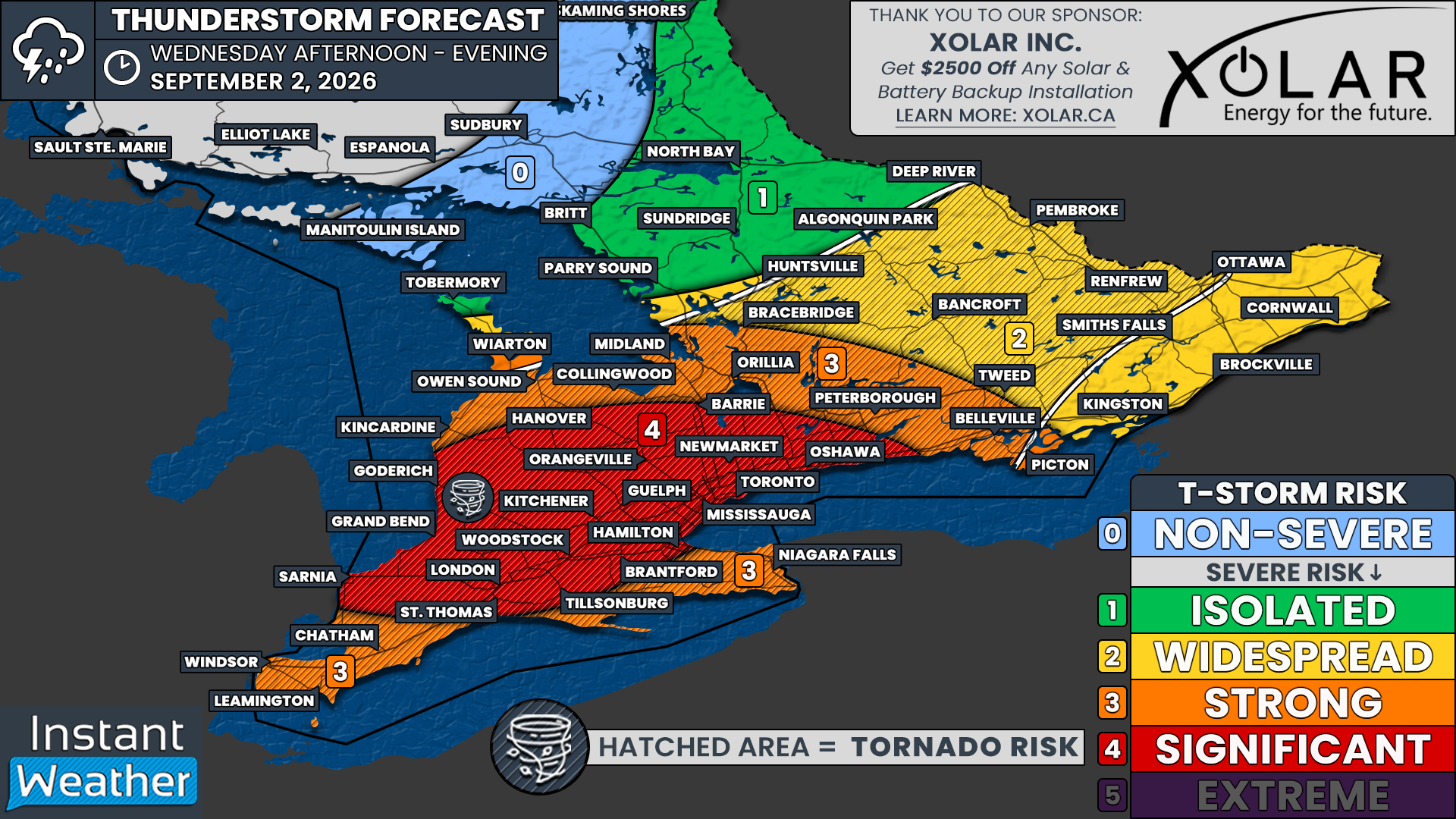
Confidence continues to grow in what is shaping up to be potentially the strongest severe thunderstorm threat Southern Ontario has faced so far this year, with a significant severe weather event possible Wednesday afternoon and evening.
Before we get to the main event, however, there is also the potential for severe thunderstorms overnight Tuesday and into Wednesday morning.
Deep Southwestern Ontario has the greatest risk during the morning hours, particularly around Sarnia and Chatham-Kent, where some models show a potentially intense round of storms around sunrise. Damaging wind gusts and large hail will be the main concerns.
Additional storms are possible elsewhere across Southern Ontario during the morning, although exactly where they develop remains uncertain.
This forecast will focus primarily on the more significant Wednesday afternoon and evening threat. For a detailed breakdown of the overnight and Wednesday morning severe weather risk, be sure to check out our previous forecast here.
Once any morning activity clears out, attention will quickly turn toward an increasingly volatile environment developing across Southern Ontario.
While there is still uncertainty surrounding the exact timing of storm development, confidence is high that any storms that develop Wednesday afternoon and evening will have the potential to become significant.
Widespread severe weather hazards are possible, including several tornadoes, destructive wind gusts and very large hail ranging from golf ball to potentially tennis ball-sized.
The highest severe weather threat is expected around the Lake Huron shoreline, extending eastward through London and Kitchener before reaching the Greater Toronto Area and Golden Horseshoe.
However, severe thunderstorms are possible almost anywhere across Southern Ontario, with at least a widespread severe risk covering much of the region.
DATA FROM WEATHERBELL
One thing that virtually all of the latest models agree on is just how favourable the environment will become for severe thunderstorms Wednesday afternoon.
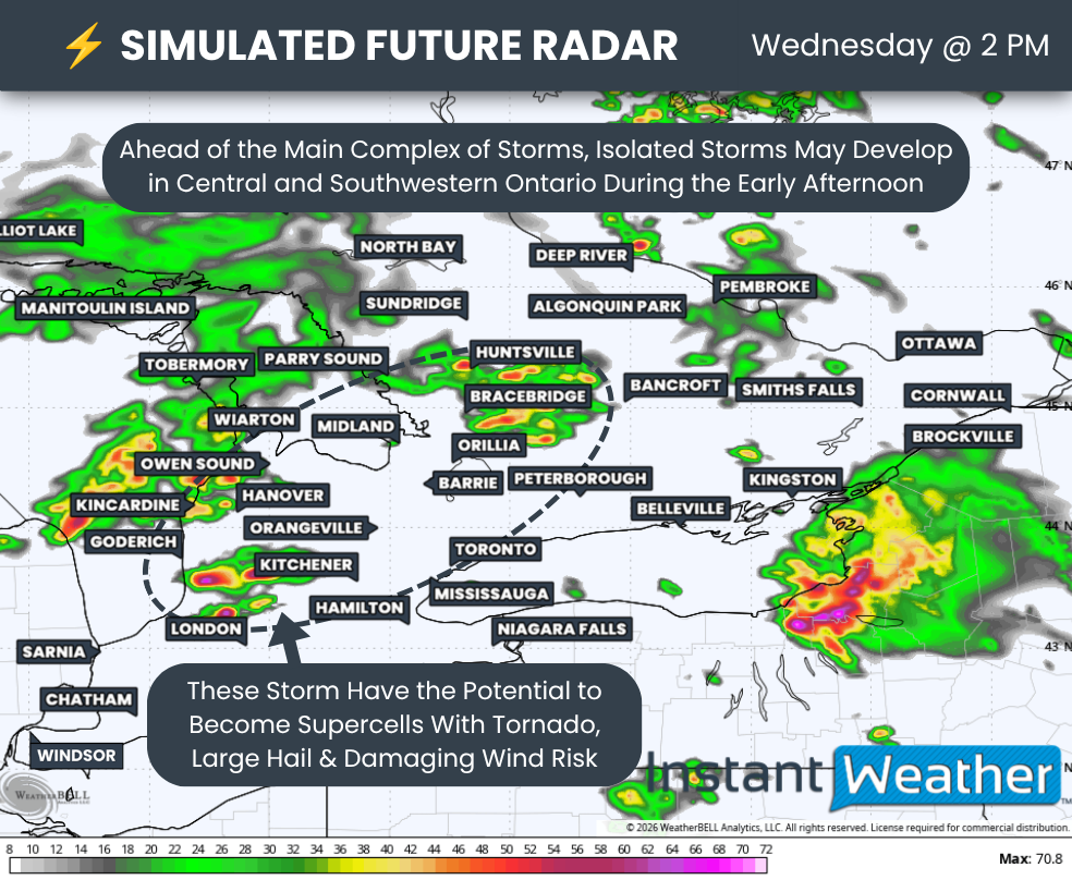
This environment will support the rapid development of strong isolated thunderstorms ahead of what is expected to eventually become the main complex of storms developing around Lake Huron.
Exactly when that main complex develops remains one of the biggest uncertainties in the forecast.
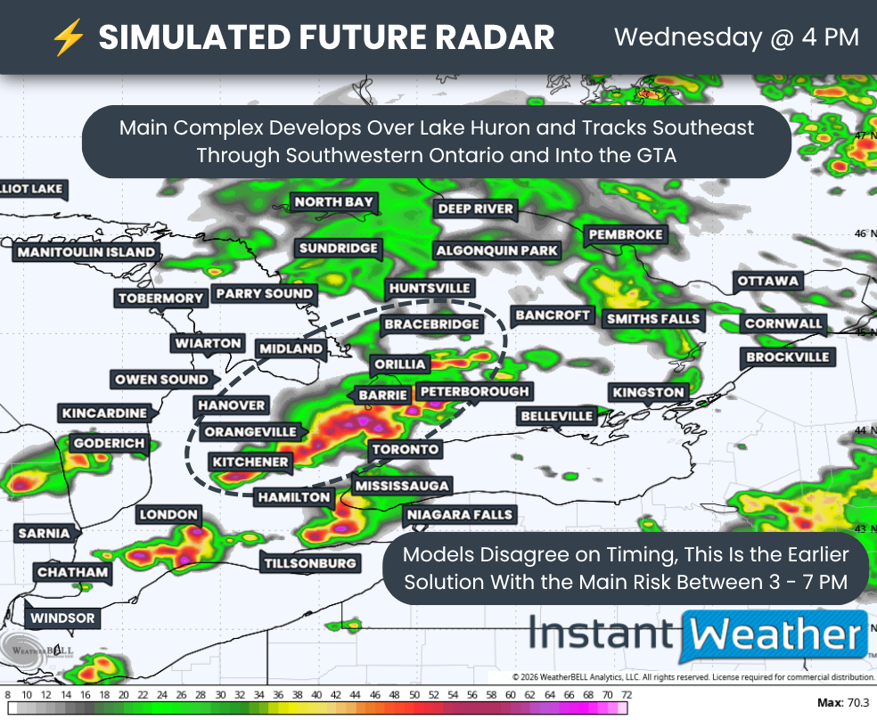
Some models develop the complex as early as 2 to 3 PM, with storms quickly sweeping through Southwestern Ontario before reaching the Greater Toronto Area and Golden Horseshoe around the dinner hour.
Other models delay the main complex until approximately 4 to 6 PM.
While a difference of only a few hours might not sound significant, it could have a major impact on the type and severity of storms we see Wednesday afternoon.
A later development would allow the atmosphere several additional hours to become increasingly unstable. More importantly, it would provide a longer window for isolated thunderstorms to develop ahead of the main complex.
These isolated storms would have the potential to remain discrete and develop into supercells, which could produce very large hail, destructive wind gusts and tornadoes.
This is why the exact timing of the main complex will be extremely important when it comes to determining the magnitude of Wednesday's tornado threat.
DATA FROM WEATHERBELL
Even models showing the earlier development of the main complex still indicate the potential for isolated thunderstorms to develop along the London to Lake Simcoe corridor during the early afternoon.
The difference is that the main complex would quickly catch up with these storms, causing them to merge into a larger and more linear line or cluster.
A faster transition toward a linear storm mode could somewhat limit the tornado threat by reducing the amount of time isolated supercells have to take advantage of the increasingly favourable environment.
That certainly doesn't eliminate the tornado risk, but it could shift the primary threat toward widespread damaging or destructive wind gusts.
Under this earlier scenario, the main complex could arrive in the Kitchener area and Greater Toronto Area as early as approximately 4 to 5 PM. If the storms remain predominantly linear, widespread damaging wind gusts would likely become the primary concern.
However, any storms that remain more discrete could still produce very large hail and tornadoes as they track through the Golden Horseshoe.
Some models also show isolated storms developing around London and Niagara, south of the main complex.
These storms would also need to be watched closely for the potential to become supercells capable of producing tornadoes, very large hail and damaging wind gusts.
DATA FROM WEATHERBELL
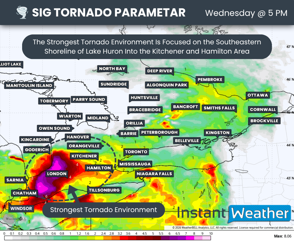
Looking at models showing a later development of the main complex, we can see why just a few hours could make such a significant difference.
Under this scenario, the main complex doesn't begin taking shape until approximately 5 to 6 PM. This would give the environment southeast of Lake Huron several additional hours to strengthen during the peak of daytime heating.
It would also provide a much longer window for isolated thunderstorms to establish themselves ahead of the approaching complex. Any isolated storm that can remain discrete in this environment could quickly become a powerful supercell capable of producing all severe weather hazards.
The later timing would also mean the main complex itself moves into Southwestern Ontario during the late afternoon and early evening, rather than during the mid-afternoon. That would allow it to encounter a potentially even more favourable environment as it tracks southeastward
We can't rule out the potential for a significant tornado somewhere within this corridor Wednesday afternoon or evening, especially if widespread storm development holds off until later in the afternoon when daytime heating has had more time to maximize the environment.
The latest data has consistently pointed toward the corridor from Goderich through Kitchener as one of the most concerning areas for the potential of a strong tornado if a supercell can develop in the right place at the right time.
It is important to emphasize that this does not mean a strong tornado will occur.
The ingredients appear favourable, but we still need a storm to develop and take advantage of those ingredients. The timing and exact placement of individual storms simply can't be predicted this far in advance.
Another important point is that the tornado threat isn't limited to the Goderich to Kitchener corridor.
While the environment appears strongest across Southwestern Ontario, including around Sarnia, London and Kitchener, conditions will remain notable farther east through the Greater Toronto Area and even into portions of Central and Eastern Ontario.
Storm development becomes more questionable across Central and Eastern Ontario, particularly around the Ottawa Valley. However, some thunderstorm activity is still possible during the afternoon and evening.
If storms are able to develop in these areas, the environment could support large hail, damaging wind gusts and potentially one or two tornadoes..
NOTE: YOU CAN CLICK ON THE graphic TO OPEN A ZOOMABLE IMAGE

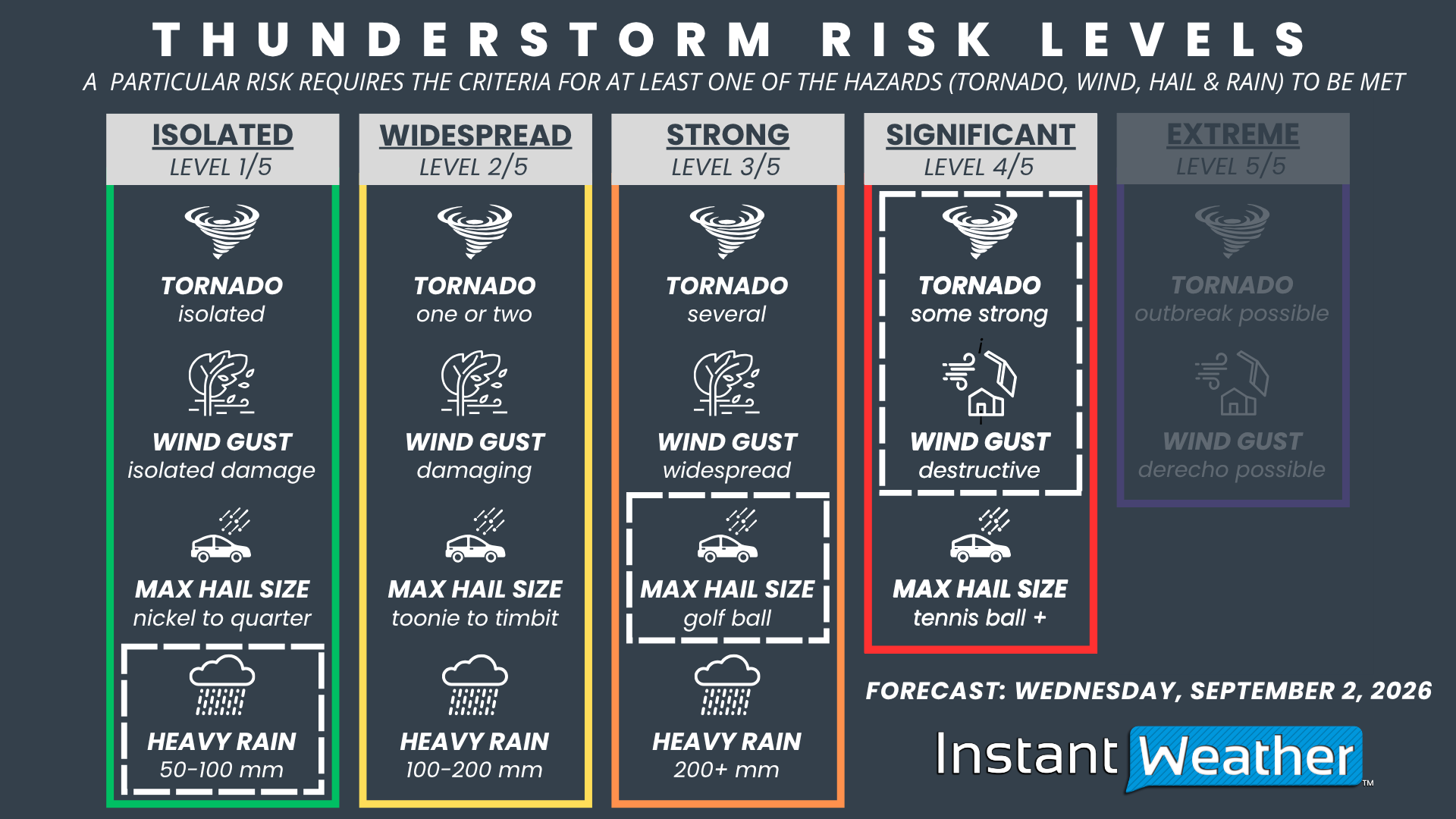
Putting everything together, we strongly considered introducing a focused zone of 'extreme' severe weather risk along the southeastern shoreline of Lake Huron.
However, there is still too much uncertainty surrounding the exact timing and evolution of Wednesday's storms to support introducing that higher risk level at this point.
For now, our maximum risk level is a 'significant' severe weather risk extending from the Lake Huron shoreline through Southwestern Ontario and into the Greater Toronto Area.
This includes Sarnia, Grand Bend, London, St. Thomas, Goderich, Woodstock, Brantford, Hamilton, Kitchener, Guelph, Orangeville, Hanover, Barrie, Newmarket, Mississauga, Toronto and Oshawa.
This significant risk is being driven by the potential for widespread destructive wind gusts and multiple tornadoes, with the possibility that one or two tornadoes could become strong if the environment develops as expected.
Golf ball to potentially tennis ball-sized hail will also be possible with the strongest supercells, along with torrential rainfall.
Surrounding the significant risk zone, we have a 'strong' severe weather risk covering Deep Southwestern Ontario, the Niagara Region and southern sections of Central Ontario.
This includes Windsor, Leamington, Chatham, Niagara Falls, Kincardine, Owen Sound, Collingwood, Orillia, Bracebridge, Peterborough and Belleville.
The environment is expected to be slightly less favourable here compared to the significant risk zone.
However, any storms that develop could still become severe and produce damaging wind gusts, hail up to the size of golf balls and tornadoes.
For northern sections of Central Ontario extending into Eastern Ontario, including the Ottawa Valley, we have gone with a 'widespread' severe weather risk. Storm development is less certain in this region, especially around the Ottawa Valley.
The environment itself could still support severe thunderstorms if storms are able to develop, with damaging wind gusts, hail up to the size of toonies and perhaps an isolated tornado.
There are still important details that need to be resolved, particularly exactly when the main complex develops and how much opportunity isolated supercells have to develop ahead of it.
Those details could significantly affect the magnitude of the tornado threat and may require adjustments to our risk zones based on the latest data on Wednesday morning.
Regardless of which timing scenario ultimately plays out, Wednesday has the potential to bring a significant and potentially dangerous severe weather event to a large portion of Southern Ontario.
Given the potential severity of Wednesday's setup, now is the time to make sure you have a reliable way to stay informed.
Download the free Instant Weather app here for the fastest sources of Environment Canada watches and warnings, along with our own custom storm notifications that can provide an early heads-up when we identify potentially dangerous weather.
We’ll also be live throughout the event on our YouTube channel, providing comprehensive storm coverage powered by the largest storm reporting community in Canada. With real-time reports from across the region combined with radar and our own analysis, our goal is to help you be among the first to know when dangerous weather is heading your way.
Make sure you have notifications and location permissions enabled in the app, and if a tornado warning is issued for your location, take it seriously and seek shelter immediately.



