Hurricane Ernesto Likely to Impact Atlantic Canada; Uncertainty Looms on Exact Track
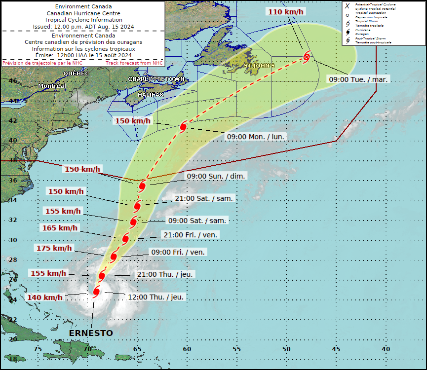
/Forecast track for hurricane Ernesto from the Canadian Hurricane Centre - August 15th at 12pm
Hurricane Ernesto is currently a Category 1 Hurricane and is still moving northeastward towards Bermuda. While it is fairly certain that the island nation will take a direct hit from the storm, its track as it continues northward into Canadian waters is much more uncertain.
In the 12pm update from the Canadian Hurricane Centre, in conjunction with the National Hurricane Center in the US, Ernesto is still expected to have some sort of impact to the Maritimes and Newfoundland, despite the uncertainty in the exact track.
Guidances from different individual weather models, as shown below, indicate potential paths that the centre of the storm may take over the next few days. In some cases, the storm may stay well offshore and only sideswipe Newfoundland with heavy rain and wind while missing the Maritimes completely. On the other hand, one model has the storm tracking straight though Central Newfoundland, which would not only greatly impact the island, but this track would also bring rain and wind further west into the Maritimes.
However, we are starting to see some agreement between some of these models that would see Ernesto stay well offshore of Nova Scotia, with only a bit of rain hitting the province, before passing just south of the Avalon Peninsula, bringing strong winds and heavy rain to Eastern Newfoundland and strong surge to coastal areas across Atlantic Canada. The swells are expected to arrive in the Maritimes beginning Saturday, with more dangerous surf starting Sunday, ahead of the storms arrival to the region early Monday.
Model Forecast Tracks for Hurricane Ernesto, Courtesy of Tomer Burg.
So what are we looking at strength wise? Ernesto is currently a Category 1 in 29°C waters. This sea surface temperature will certainly help the storm strengthen, however, dry air is being pulled into the centre of the storm which is limiting its organization. The warm waters and dry air, combined with some moderate vertical shear (which needs to be low in order for a hurricane to survive and strengthen), means that Ernesto will strengthen to a strong Category 2 Hurricane.
As the storm continues to travel north-northeastward beyond Bermuda, it will encounter cooler waters and shear will increase, which will work to weaken it back down to a Category 1. As it moves into Canadian waters, the sea surface temperatures fall below 26°C. This is the magic number for hurricane development and growth so at this point, it will weaken even further. Ernesto expected to travel through the region starting as a low-end Category 1 and weakening to a post-tropical storm, with winds in the centre of the storm in the range of 110-150km/h.
Forecast Track and Intensity of Hurricane Ernesto with Sea Surface Temperatures, courtesy of Tomer Burg.


