Update: Freezing Rain Risk Extended West, Heavy Snow Still Expected Across Central Newfoundland

The latest weather model guidance has extended the freezing rain threat westwards into Central Newfoundland and now includes parts of the South Shore. This also decreases the amount of accretion for much of the Avalon Peninsula with the St. John’s Metro area now expecting closer to 12mm (0.5”) of freezing rain. This is still a considerable amount of ice buildup and can very easily disrupt power supply due to downed tree limbs and lines.

This western shift in the heavier freezing rain will decrease some of the snowfall totals slightly on the Bonavista Peninsula and the Western Avalon. However, the amount of snow for Central Newfoundland remains unchanged at over 50cm and one model even predicting over 100cm for Gander. This is an unlikely situation, but local amounts in over 75cm is not entirely out of the question.

Despite the decrease in both ice accretion and snowfall accumulation in parts of Eastern Newfoundland and the Avalon Peninsula, this is still going to be a major storm for the province. If you do not already have all of your essentials gathered, make sure to do so early Friday morning. We will be providing updates throughout the duration of the storm and possibly hosting a livestream so stay tuned.

Potentially Historic Ice Storm With Significant Impacts Beginning Overnight Tonight

A large storm, stretching all the way down to Texas, is expected to bring crippling amounts of snow and ice starting overnight tonight and continuing straight to Saturday morning. The storm has already started bringing rain across the province which will transition over to freezing rain for most regions overnight as the temperature falls and hovers around the freezing mark. The freezing rain will continue to fall throughout the day tomorrow before tapering off Saturday morning. Some of the province, particularly Cumberland County and northern parts of both Inverness and Victoria Counties, will escape the freezing rain threat and precipitation will fall as snow with amounts up to 30cm possible. On the other hand, much of the Southern Shore, including Yarmouth and Liverpool, will see a bit of freezing rain, but the precipitation will mostly fall as rain.

The threat of major ice accretion of over 25mm (1”) exists in a large swath from Digby and the Annapolis Valley, across to Antigonish in the Highlands, and through Cape Breton up to Sydney. The Halifax area should expect closer to 25mm of ice accretion on surfaces. This amount of ice will be more than enough to bring down tree limbs and powerlines and widespread, long-term power outages are entirely possible throughout the entire province. These issues will be further compounded by having wind gusts of up to 60 km/h throughout the duration of the storm. These types of ice events are very dependent on the temperature and usually a difference of a single degree is enough to change the type of precipitation falling, however the general consensus of the major weather models, as well as what this storm as already done in the United States, suggests that this will be a predominantly freezing rain event.

There is considerable agreement between weather models that this be the strongest ice storm the province has seen in quite some time. Please ensure that you have all of your essentials ready ahead of this storm. An Ice Storm Preparation article will be posted this evening and we will be providing updates throughout the duration of the storm, including a possible livestream.

Another Stormy Day

Valid: Thurs Feb 3 - Fri Feb 4

Another Stormy Day

What is interesting about this storm is that it is not on the weekend. Other than that, PEI is in the path for a large blast of winter weather starting on Friday. We will be looking at significant snow, and some areas of the province will be looking at ice pellets. With the current path, areas around Wood Islands could see some freezing rain late Friday night.

TIMING:

Current models are indicating that on Thursday, during the day, across PEI we will see some rain. The system starts to arrive in PEI just after midnight in the early morning hours of Friday. It will snow heavy during the daylight hours and the majority of the snow will be down by Friday evening. There will continue to be lingering flurries through the day Saturday giving us an additional 2-5cm.

Throughout the storm, especially during the early morning hours of Friday, we can expect to see ice pellets in Kings and parts of Queens County. This will be mixing in with the snow.

TOTAL AMOUNTS ACROSS THE PROVINCE:

The below accumulations are what we can expect to see on Friday:

SNOWFALL

Prince County – 30-40 cm

Queens County – 30-40 cm

Kings County – 30-40 cm (areas from Stratford to Georgetown to the North Shore and East Point)

Kings County - 20-30 cm (areas from Stratford to Georgetown to Wood Islands)

WIND: Winds will not be as large of a factor with this system, however, they will still be significant enough to blow the snow around causing some white out conditions. Overall, winds should be 40-60 km/h from the north. Saturday will see the winds continue in the 40-60 km/h range.

TEMPERATURE: Thursday we will see temperatures just above the freezing mark in the 3-5 C range. They will begin to drop later in the evening on Thursday and from the early morning hours of Friday through to Saturday morning temperatures should be around the -3 to -5 C range. By noon on Saturday, temperatures will begin to drop and by evening we could see them dipping to -10 to -15 C. Sunday could see temperatures dipping even further to -15 to -20 C.

Any shift in the front could greatly vary the precipitation types and quantities. We will continue to monitor this system and keep you updated with any significant changes.

The significant snowfall, combined with the consistent winds and the already high snowbanks along the roadways will cause white out and hazardous driving conditions during Friday and into Saturday. Please stay home unless absolutely necessary. Always adhere to the recommendations of the RCMP and PEI Public Safety.

As always, be safe and let us know what you are experiencing in your areas.

Storm chip Probability: 100% (again)

IWPE Team (Mike S, Harry S)

Intense System to Bring Heavy Snow and Ice Storm Across the Province Over the Course of Three Days

A potent winter storm that has wreaked havoc across much of the Midwest United States will continue to blast northeast and arrive on the West Coast tomorrow morning and by the time it’s done, it could dump over 75cm of snow over a large portion of Central Newfoundland and potentially cripple parts of Eastern Newfoundland and the Avalon Peninsula.

The storm will initially bring rain as it most eastward across the Island throughout the day Thursday before transition to snow for most during the overnight hours. From there, the storm will set up like a conveyor belt, bringing almost non-stop snow for Friday and Saturday. Western Newfoundland and along the South Coast will see 30-50 cm of snow by late Saturday evening. Central Newfoundland, on the other hand will see upwards of 75cm and possibly even more, especially to the Northeast in Gander and up into the New-Wes-Valley Region and potentially Bonavista. With the shear amount of snow expected to fall It is worth noting the there may bit a bit of freezing drizzle as the rain transitions to snow in these regions, but it will not be severe as opposed to further east.

The Avalon Peninsula and most of Eastern Newfoundland will continue to experience rain into the mid-morning on Friday. At this point, until the the early afternoon on Saturday, the temperature will sit around the freezing mark. This will result in possibly close to 36 straight hours of freezing rain, except for the Southeast Avalon where the temperature will stay a bit higher and the rain will persist. The areas that experience freezing rain will likely see a lot of it, even well over 25mm (1 inch) of accretion possible for the St. John’s Metro area. This amount of ice will be more than enough to bring down tree limbs and powerlines and widespread, long-term power outages are entirely possible. These issues will be further compounded by having wind gusts of up to 60 km/h throughout the duration of the storm. However, this is very temperature dependent and one or two degrees could mean the difference between a major ice storm and heavy rain. By Saturday evening, the precipitation will transition to snow for approximately 12 hours of snow and could bring up to 20cm for the Northwest Avalon and less than 10cm for the rest of the Peninsula.

This powerful storm will certainly bring heavy snow that will have many Newfoundlanders digging out. The uncertainty, however, lies in how much freezing rain will fall in Eastern Newfoundland and parts of the Avalon Peninsula. There is considerable agreement between weather models that this be the strongest ice storm the province has seen in quite some time. Please ensure that you have all of your essential ready ahead of this storm and we will continue to provide updates, including an Ice Storm Preparation article tomorrow afternoon and throughout the duration of the storm.

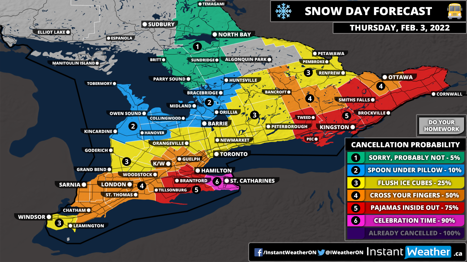
Snow Day (Bus Cancellation) Outlook for Thursday, February 3, 2022

Heavy snowfall has brought widespread accumulation between 10-25cm throughout parts of Southwestern and Central Ontario which is expected to continue into Thursday. By the morning, the focus will have turned to the Niagara region and Extreme Southeastern Ontario where more heavy snow is expected throughout the day on Thursday.

With a Winter Storm Warning in effect from Environment Canada for the Niagara region and Hamilton means the chance of school bus cancellations and school closures is quite high ranging from 75-90%. Eastern Ontario also has a fairly good chance as heavy snow will impact the morning commute combined with some icy road conditions due to the previous rain freezing up as the temperatures drop. However, there is no current warning from Environment Canada out there so we’ve given them a 75% chance as it’s not set in stone.

A fairly expansive zone including Sarnia, London, K/W and Guelph has a 50% chance. This is mainly because the snow will end overnight, but with nearly 20cm on the ground in some areas, it’s possible that roads might not be clear by morning. The probability will quickly drop off to the north and west where the second wave isn’t expected to have much of an impact and the first wave will end around midnight giving sufficient time for clean up by morning. Can’t be ruled out though mainly due to the icy road conditions, but this will be a local issue and we shouldn’t see many school bus cancellations outside of the areas we mentioned.

It should be noted that there is higher confidence in this forecast compared to the forecast for today. We saw many cancellations in the west, but many school boards decided to roll the dice further east despite the forecast so they didn’t cancel buses. This likely won’t be the case for Thursday as heavy snow will be ongoing and it won’t depend much on forecasted conditions later in the day.

If there are any cancellations tomorrow morning, you can be sure we’ll be up bright and early beginning at 6 AM with our bus cancellations live blog to keep you updated.


Disclaimer: Instant Weather has zero authority when it comes to bus and school closures. It is completely up to the school boards, bus companies, and local authorities as well as being up to parents to decide what is best for their children. This is simply our best guess based on our forecast. Also note that due to the current pandemic, some school boards have changed their policies on school bus cancellations. Some will continue the school day in a virtual format should there be school bus cancellations - check with your local board for more details.

Close Call for Second Wave of Multi-Day Snowfall Event Across Southern Ontario; 10-20cm Possible for Niagara and Extreme Southeastern Ontario on Thursday

IMPORTANT: This map is for ADDITIONAL snowfall from Thursday Afternoon to Friday Morning. Our forecast for the first wave HERE still applies until Thursday Morning.

Widespread snowfall continues across Southern Ontario as the first wave of the multi-day snowfall event brought rain to start and then transitioned over to snow later in the day. Most areas throughout Southwestern Ontario and into Central Ontario are still on track to see between 10-25cm of snow by Thursday morning as covered in our forecast from Tuesday. Now our focus turns towards the second wave which will begin to affect Southern Ontario after the first round tapers off late Thursday morning and continue into early Friday.

The latest data suggests that the second wave of precipitation will track further to the southeast making for less of an overall impact on Southern Ontario. Initially, we thought it could deliver another 10-25cm of snow on top of what we received from the first round. Those higher totals will now be reserved for the Niagra region and into Eastern Ontario along the American border. Regions roughly northwest of a line from Windsor through K/W and Ottawa will see very little accumulation from the second wave with a very sharp cutoff between heavy snow and no snow.

With this southeasterly change in the track, it appears that there won’t really be a break in the snow between the two waves. To avoid confusion, we’re still treating it as two different waves so heavy snow will be ongoing throughout the afternoon stretching along the Lake Erie shoreline and into the Niagara region. This will also move across Lake Ontario and into Eastern Ontario hugging the St. Lawrence River.

The more persistent snow will be found southeast of a line from Leamington through Hamilton and Smiths Falls with the worst conditions during the late afternoon and evening on Wednesday. The Niagara region and into Extreme Southeastern Ontario including Brockville and Cornwall can expect around 10-20cm of additional snow by the time the snow ends early Friday. Some localized totals could approach 25cm particularly over the higher elevations of the Niagara region but aren’t guaranteed.

Other surrounding regions including Norfolk County through eastern sections of Hamilton and into Kingston can expect around 6-12cm of snowfall accumulation from this system. Areas just to the northwest of this line including Windsor, London, K/W, the GTA, Peterborough and Ottawa will see at most a few centimetres of snow from this wave. However, the gradient is quite tight with this one and a slight shift could increase the totals in those areas closer to 4-6cm so pay attention to the local ranges.

Snow will continue overnight into early Friday morning. It should lighten fairly quickly after midnight and fully clear out of the province by sunrise on Friday. If possible, try to delay any travel until Friday if you are in the affected region. Heavy snow late Thursday combined with 30-50km/h wind gusts will make for poor driving conditions.

Snow Day (Bus Cancellation) Outlook for Wednesday, February 2, 2022

A multi-day snowstorm is set to bring between 10-30cm of snow to much of Southern Ontario starting Wednesday and continuing into Friday. As a result, widespread school bus cancellations and school closures are likely on Wednesday and will likely occur on Thursday as well. What makes this event tricky is the timing where the worst conditions will occur during the afternoon and evening on Wednesday. So any cancellations for Wednesday won’t be based on the conditions in the morning and will come down to each school board looking at the forecast and being proactive.

Based on this, we have given a widespread 75% chance of a snow day for much of Southern Ontario. We believe buses should be cancelled for all of Southern Ontario. However, given the lack of watches/warnings at this time from Environment Canada (most areas except for Deep Southwestern Ontario, Hamilton and Niagara region only have a weather advisory in effect as of 8:20 PM) there is some question on if it will happen. We are fairly certain on Deep Southwestern Ontario where a winter storm warning should be severe enough for a snow day so we gave the Windsor, Chatham and Sarnia region a 90% chance.

The GTA has a slightly lower chance ranging from 25-50% mostly because these are urban school boards and they tend to be less reliant on busing. Without a watch/warning, they are unlikely to call a snow day based on their previous track record. The chance is still there, but it’s not guaranteed. This also applies to the Ottawa area which usually has a higher threshold for cancellations.

If there are any cancellations tomorrow morning, you can be sure we’ll be up bright and early beginning at 6 AM with our bus cancellations live blog to keep you updated.


Disclaimer: Instant Weather has zero authority when it comes to bus and school closures. It is completely up to the school boards, bus companies, and local authorities as well as being up to parents to decide what is best for their children. This is simply our best guess based on our forecast. Also note that due to the current pandemic, some school boards have changed their policies on school bus cancellations. Some will continue the school day in a virtual format should there be school bus cancellations - check with your local board for more details.

First Wave of Multi-Day Snowstorm To Affect Southern Ontario With Widespread Accumulation Between 10-25cm Starting Wednesday

It’s increasingly likely that February will start off with not one but two heavy blasts of snow throughout Southern Ontario over the next 3 days. The first wave will begin early Wednesday morning and last into Thursday morning while the second wave will impact the region from Thursday afternoon to Friday morning. Between the two waves, we could be looking at widespread snowfall totals by Friday ranging from 20-40cm. Blowing snow will also be a concern throughout those timeframes so travel is strongly discouraged as road conditions will be quite poor.

As we mentioned in our preliminary forecast, there is more confidence in the snowfall totals associated with the first wave which will mainly target Southwestern and Central Ontario during the day on Wednesday. As we look towards the second wave, there is a lot of disagreement with the exact track making for highly variable snowfall totals across Southern Ontario.

The focus of this forecast will be on the first round where we have more confidence and we’ll make a separate forecast sometime on Wednesday for the second wave. We did include a very preliminary forecast for the second round HERE, but the latest data has trended further to the southeast so this will likely need to be significantly revised.

STORM TIMING

NOTE: For those that prefer daily snow totals, we’ve included what to expect by the end of Wednesday in the regional graphics above. Keep in mind that the timeframe for these graphics is different from the accumulation map for the first wave.

We will start to see the first bands of precipitation enter from the west sometime late Tuesday evening around midnight. For areas around Georgian Bay and the Bruce Peninsula, we may see a few hours of mixing with some freezing rain, but it will quickly switch over to snow by the early morning hours. For Southwestern Ontario, the rain and mixing will be more sustained as the warmer air holds on so the transition to snow won’t occur until later in the morning.

Moderate to heavy snowfall will be ongoing throughout Southwestern and Central Ontario during the afternoon and evening on Wednesday. The Golden Horseshoe and Eastern Ontario won’t start to feel the impacts of the first wave until later in the day towards the afternoon with a few hours of mixing also possible.

The snow associated with the first wave will continue overnight and into Thursday while slowly clearing from the northwest just after midnight. It should taper off for the most part by the late morning on Thursday giving us a break for a few hours before the second wave will move in during the afternoon.

This second wave is still unclear in the exact impact it will have on our region, but it’s a safe bet to say that the Niagara/Hamilton region and into Extreme Southeastern Ontario will see additional snow late Thursday into Friday. Accumulation will drop off quite fast to the northwest, but the track of the second wave will determine how far west the significant snowfall totals make it into the region. More details on Wednesday.

SNOWFALL ACCUMULATION

Based on the latest data, we’ve made some minor changes to our original forecast for the first wave. The main change is shrinking the 20-30cm zone which now only includes Southwestern Ontario (Windsor, Sarnia, London etc.). General snowfall totals here will likely end up somewhere around 25cm give or take a few centimetres with a few areas approaching 30cm. Now, it should be noted that rain and mixing here early Wednesday could inhibit accumulation on the ground for a few hours after the switch over which is hard to account for in the forecast.

Further east around the Golden Horseshoe, we’ve also reduced the snowfall totals here too as more mixing around the shoreline will likely reduce snowfall totals. The GTA can expect around 10-20cm with up to 25cm towards Hamilton and higher elevations of the Niagara Region by Thursday morning.

The forecast hasn’t changed much for Central Ontario where we are still expecting widespread accumulation between 15-25cm. Some of the data we’ve reviewed indicate that an area east of Georgian Bay including Muskoka into Bancroft could pick up closer to 25-30cm locally due to some lake enhancement.

Lower totals are expected for Eastern Ontario with around 5-15cm depending on your location. Although this is only for the first wave and Eastern Ontario will likely face the brunt of the second wave so they’ll catch up in snow totals late Thursday into Friday.

This will likely be our final forecast for the first wave unless there are any major changes in the model data this evening. We will pass along any last-minute updates if needed. Check back for a more detailed forecast on the second round sometime Wednesday once it becomes clearer on the impact it will have on Southern Ontario.

Multi-Day Snowstorm Possible Across Southern Ontario Between Wednesday and Friday; Up to 40cm of Snow Possible

It certainly has been a snowy start to 2022 across Southern Ontario as we saw the most impactful snowstorm in years a few weeks ago. Well, it appears that February will be continuing the snowy trend as a multi-day snowstorm will set up what is best described as a snow ‘conveyor belt’ between Wednesday and Thursday. The snowfall will predominantly come in two separate waves within those 3 days with the first round starting Wednesday morning and lasting through to Thursday morning. Then we will get a few hours of reprieve from the snow before a second wave hits late Thursday and into Friday morning.

Based on the two different waves, we will be forecasting this storm with two separate snowfall forecast maps. At this point, there is more confidence in the first wave as we’re closer and there’s less uncertainty in the track. The second wave is still 2-3 days away and models have diverged in two different tracks which would have significant implications on the totals we see across Southern Ontario. Between the two waves, it’s not out of the question that we see widespread accumulation ranging from 20-40cm by Friday or even more.

In terms of raw accumulation over the three days, this event may overperform the last major storm that we saw that delivered widespread totals between 40-60cm. However, there is a big difference to see this accumulation spread over 48-72 hours compared to contained within a 12-hour timeframe. The impacts shouldn’t be as severe, but they will certainly be more prolonged so several days of travel delays and school bus cancellations are likely. This could also change if the second wave has less of an impact on our area.

This storm is expected to begin late Tuesday evening with the initial bands of precipitation moving into the Bruce Peninsula and areas around Georgian Bay. It appears that a few hours of rain is possible and maybe some freezing rain as temperatures hover near or slightly above the freezing mark. However, this will quickly change as we head into the overnight and Wednesday morning with temperatures set to drop below the freezing mark. Heavy snow will be ongoing throughout the morning on Wednesday and will begin to spread to the southeast later in the day as more sustained and intense bands of snow move in from the southwest.

It should also be noted that there is the risk of some freezing rain and mixing for a few hours during the day on Wednesday before switching over to heavy snow. This is particularly a concern for the Niagara Region and in Eastern Ontario which could see more prolonged freezing rain before the switch over. The worst conditions with the first wave will be felt throughout the evening and overnight hours on Wednesday. Heavy snow combined with 30-50km/h wind gusts will lead to blowing snow and very poor driving conditions. Travel should be avoided during this time and perhaps save any travel until Friday after the second wave.

The snow will begin to lighten from northwest to southeast overnight Wednesday and early Thursday morning. Most areas will likely see a short break from the snow late Thursday morning to the afternoon before the second wave moves in. The exception is for areas along the Lake Erie shoreline and Eastern Ontario which will see the moisture streams associated with both waves merge so there be not much of a break here.

As for the snowfall totals from the first wave, we are looking at the highest totals throughout Southwestern Ontario where general accumulation will range from 20 to 30cm including Windsor, Sarnia, London, K/W and into the Hamilton region. A few localized totals above 30cm by Thursday morning can’t be ruled out.

Further to the northeast, we have an expansive 15-25cm zone that includes much of the GTA and into Central Ontario. There is a particular area east of Georgian Bay including the Muskoka-Parry Sound region that could experience some lake enhancement Wednesday morning which could push totals slightly above 25cm.

Eastern Ontario will avoid most of the snow from the first round with totals ranging from 5-15cm depending on the location with higher amounts further west. This is mostly because the snow starts later and will merge with the second round so this will be covered in our second forecast.

Now, while there is fairly good confidence in the forecasted totals from the first wave, it’s not 100% so we still may need to make adjustments. We will re-evaluate the latest data on Tuesday afternoon and update the first wave forecast by early evening if needed. Any changes should be minor so don’t expect any major shifts or significant changes in the forecasted totals.

We will now lightly touch on the second wave which is still in flux when it comes to all the different models. This map might look quite familiar as the track of the second wave is similar to the major blizzard we saw a few weeks ago. As we saw with the last storm, it really comes down to the exact track in how much snow we received and last time it tracked further to the west which affected more of Southern Ontario. Some models suggest this more western track while others have pulled it further southeast. This southeastern track could be significant enough that it could miss Southern Ontario entirely so keep in mind our forecast right now is very preliminary. We’ve split the event into two waves so we could focus on the wave we have more confidence in.

We are going with the track that has the most model agreement with the second wave. This track would bring a fairly intense band of snow stretching from Windsor through the Golden Horseshoe and into Eastern Ontario. The heaviest snow is expected late Thursday continuing overnight and into Friday morning. Hourly snowfall rates during the evening and just after midnight could be quite intense ranging from 2-6cm which like the last storm, will pile up quite fast but not as intense as we saw with the 10+cm hourly rates. The snowfall will start to wind down late Friday morning as the system moves out of our region. It looks like Eastern Ontario will be the last to see the snow taper off and should be out of it by the noon hour on Friday.

The current track would result in an additional 20-30cm (locally 30+cm) of snow for the Niagara/Hamilton region and into Extreme Southeastern Ontario. Further west, we are looking at between 15-25cm for Windsor/London through the GTA and into the Ottawa Valley. With this track, the gradient will be quite tight like with the last storm so expect the totals to drop off quite fast as you head to the northwest. Totals here will range from 5-15cm including Sarnia, K/W, Barrie and Bancroft. If the storm starts trending more to the southeast then this area may end up with barely any snow so it’s not set in stone at this point.

A more detailed forecast for the second wave will be issued on Wednesday once we get a better idea of the track. This includes more specific timing and accumulation. Right now the focus is on the first wave and then we will turn our focus to the second wave. Stay tuned for further updates.