Understanding the Radar in the Instant Weather App
/The Instant Weather app provides several radar options to help you track precipitation, see how weather systems are moving, and explore forecasts of future precipitation.
This guide explains the different radar types, how to use the radar controls, how to interpret precipitation colours, and how to view weather alerts and Instant Updates directly on the map.
These instructions apply to the Updated Radar Page Style. You can select your preferred radar layout under Settings > Radar Page Style. If your radar screen looks different from the screenshots in this guide, check which page style you have selected.
On This Page
Accessing the Radar
Tap Radar in the navigation bar at the bottom of the Instant Weather app.
The radar map displays precipitation, along with controls for navigating the map and viewing past and future radar information.
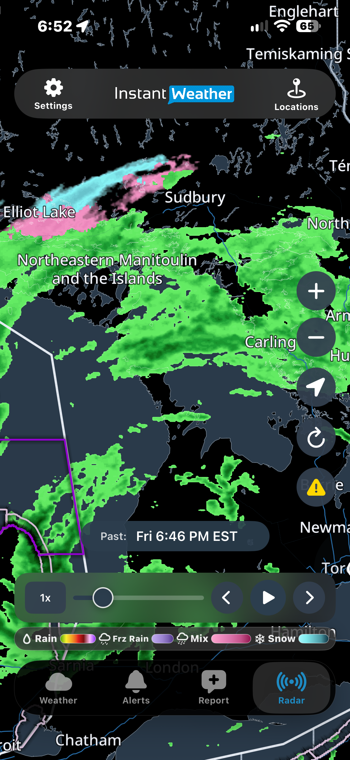
Main Radar Screen
Choosing a Radar Type
Three radar options are available:
Raw Mosaic
Mosaic
Smooth Mosaic
You can switch between these options by opening Settings > Radar Source.
Raw Mosaic
Raw Mosaic displays radar imagery directly from Environment and Climate Change Canada (ECCC).
It shows precipitation intensity rather than precipitation type. The colour legend indicates precipitation rates in millimetres per hour (mm/h).
Raw Mosaic includes approximately:
3 hours of past radar
1 hour of future radar provided by Environment Canada
This provides a total of approximately four hours of radar information.
Raw Mosaic is useful for examining the location and intensity of precipitation using Environment Canada's radar imagery.
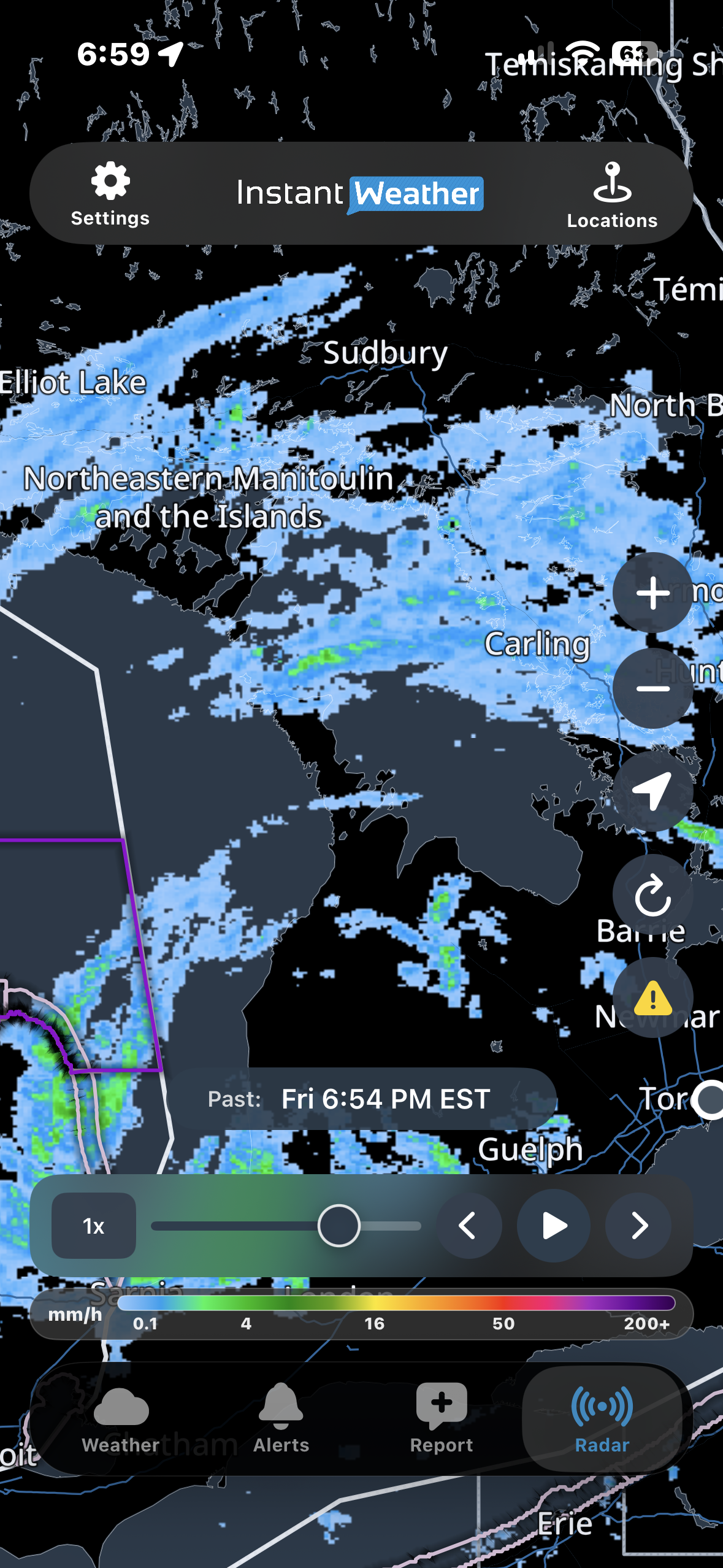
Raw Mosaic with Intensity Legend
Mosaic
Mosaic displays precipitation using colours that help distinguish rain, snow, freezing rain and mixed precipitation.
It includes both past radar observations and future radar forecasts, allowing you to follow precipitation as it moves through an area.
Mosaic displays radar information in individual frames, so the animation may appear less continuous than Smooth Mosaic.
Smooth Mosaic
Smooth Mosaic provides the same general precipitation information as Mosaic, but produces a smoother animation between radar frames.
This can make it easier to follow the movement of precipitation over time.
Both Mosaic and Smooth Mosaic use the same precipitation-type legend.
Understanding Radar Colours
The radar legend helps you interpret the colours displayed on the map.
Mosaic and Smooth Mosaic
The legend identifies four precipitation types:
Rain: Colours range from green through yellow, orange and red, with green indicating lighter rain and red indicating heavier precipitation. White areas within intense red precipitation may indicate hail.
Freezing rain: Purple shades.
Mixed precipitation: Pink shades.
Snow: Light blue to cyan shades.
Colour variations within each category help indicate precipitation intensity.
The introductory screenshot shows rain, mixed precipitation and snow occurring close together around Sudbury and Manitoulin Island.
Raw Mosaic
Raw Mosaic uses a precipitation intensity scale rather than identifying precipitation types.
Its legend displays precipitation rates in mm/h, with higher values indicating more intense precipitation.
Always check the legend for the selected radar type, since the colours have different meanings in Raw Mosaic and the other radar options.
Using the Radar Timeline
The timeline at the bottom of the radar map allows you to view past radar observations and future radar forecasts.
Playing and Pausing Radar
Tap Play to animate the radar.
The animation shows how precipitation has moved and how it is forecast to move.
Tap Pause to stop the animation.
Moving Through Radar Frames
You can also navigate the radar manually:
Timeline slider: Drag the slider to move to a particular time.
Back arrow: Move backward one radar frame.
Forward arrow: Move forward one radar frame.
Radar frames generally advance in six-minute increments.
When moving quickly through the timeline, images may briefly appear blurry while radar data loads.
Adjusting Playback Speed
Tap the playback speed control, such as 1x, to change the animation speed.
Slower speeds allow you to examine changes more carefully, while faster speeds help you review longer periods of radar activity.
Past and Future Radar
The time displayed above the timeline indicates whether you are viewing past or future radar information.
Past radar shows previously observed precipitation.
Future radar shows forecast precipitation and how it may move or develop.
Future radar is a forecast, so actual conditions may differ.
Radar Map Controls
Several buttons along the side of the radar map help you navigate and customize the display.
Zoom In and Out
Tap + to zoom in or − to zoom out.
You can also use touch gestures to zoom and move around the map to examine different areas.
Centre on Your Location
Tap the location button to centre the radar map on your current location.
iPhone and iPad: The button displays a location arrow.
Android: The button displays a crosshair symbol.
Your device may need location permissions enabled for this feature to work.
Refresh Radar
Tap the Refresh button to reload radar information and return to the latest available observed radar frame.
Show or Hide Weather Alerts and Instant Updates
Tap the yellow warning triangle to show or hide weather alert and Instant Update outlines on the radar map.
These outlines identify areas affected by official weather alerts or Instant Updates.
Turning them off can make it easier to examine precipitation without additional map overlays.
Saved Locations
Tap Locations at the top of the screen to access your saved locations and select an area to view.
Viewing Weather Alerts and Instant Updates on the Radar
The radar map displays outlined areas for official weather alerts issued by government weather agencies in Canada and the United States, as well as Instant Updates from Instant Weather.
Instant Weather does not issue official weather alerts. Official alerts are issued by government weather agencies. Instant Weather provides its own updates and forecasts to help keep you informed about developing weather conditions.
Understanding Alert Outline Colours
Canadian weather alerts
Environment and Climate Change Canada (ECCC) uses colour-coded alert levels, including yellow, orange and red, to indicate the level of risk associated with a weather event.
The alert outlines on the radar map reflect these levels.
United States weather alerts
In the United States, alert outline colours may vary according to the type of weather alert.
For example, flood-related alerts may appear green, frost advisories blue and gale warnings purple.
This means that alert outline colours may have different meanings depending on whether the alert was issued in Canada or the United States.
Instant Updates
Instant Weather also provides its own Instant Updates to share information about significant weather conditions.
These may include areas where our team has identified possible storm rotation or other notable weather hazards that may not be covered by an official government alert.
Instant Updates may also appear as outlined areas on the radar map.
Viewing Alert Details
To view details about a weather alert or Instant Update:
Make sure alert outlines are enabled using the yellow warning triangle.
Tap an outlined area on the radar map.
A coloured banner appears showing the applicable alert or Instant Update.
Tap the information (i) button on the banner.
The Current Alerts, Forecasts & Notifications panel opens.
Tap a heading to expand or collapse its details.
Tap X to close the panel.
If more than one alert or update applies to the selected area, you can review them individually.
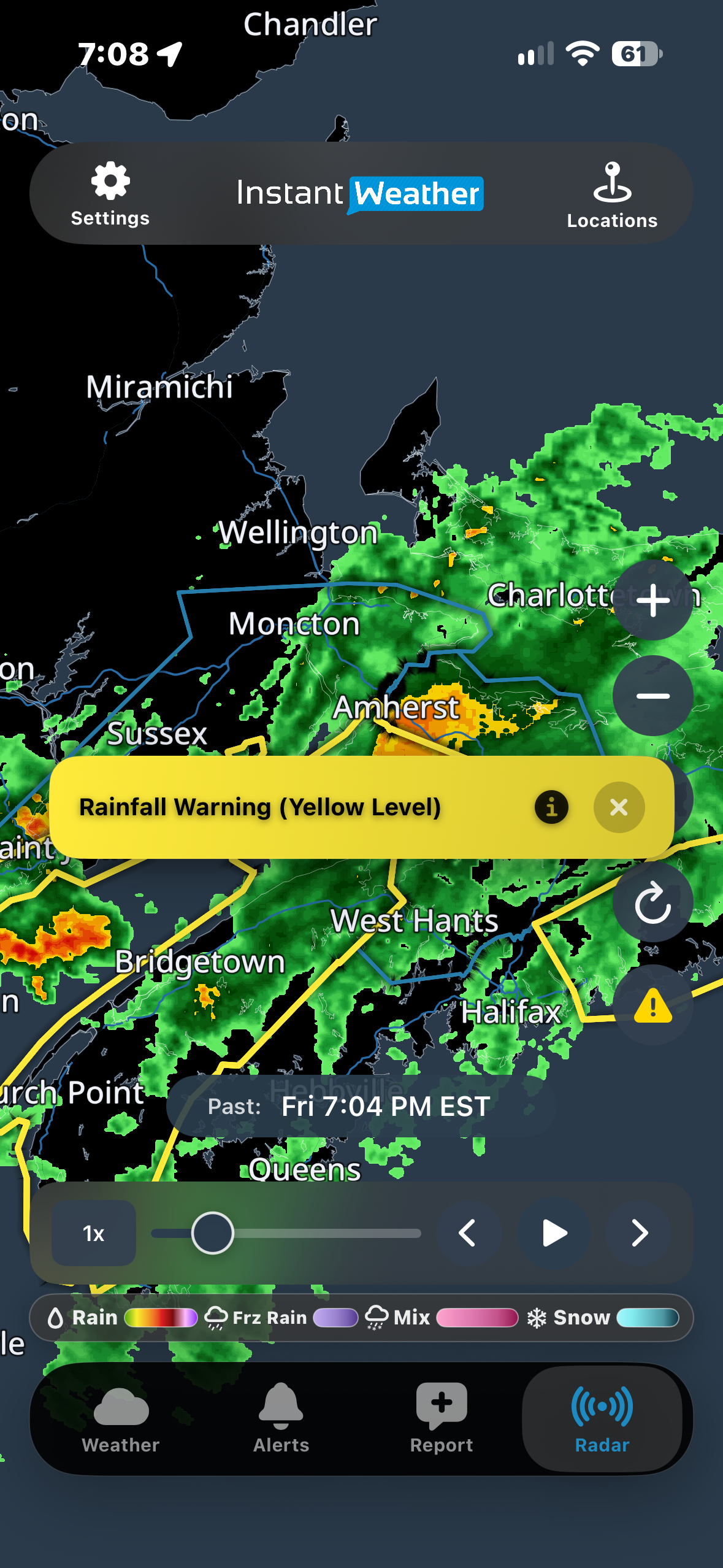
Selecting a Weather Alert on the Radar
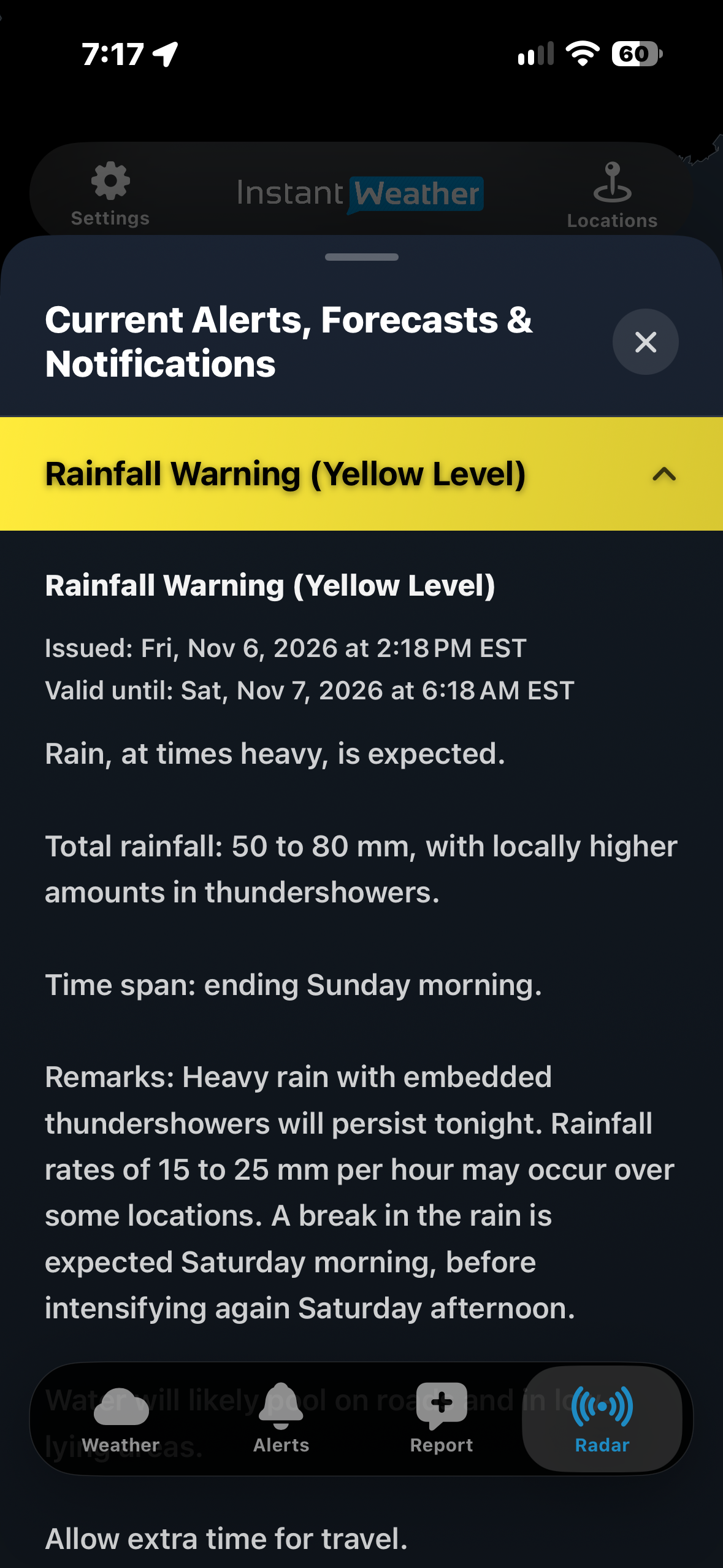
Viewing Weather Alert Details
Instant Weather Forecasts and Official Weather Alerts
In addition to official government weather alerts, Instant Weather provides its own forecasts and weather updates.
Instant Weather forecasts may appear in the alert banner on the Weather page and in the Alerts section.
On the radar map, Instant Weather forecasts do not have their own outlined areas.
However, when you tap an area affected by an official government weather alert and then tap the (i) button, the Current Alerts, Forecasts & Notifications panel may also display applicable Instant Weather forecasts.
For example, the panel may contain both an Environment Canada Snowfall Warning and an Instant Weather Snowfall Forecast.
Tap either heading to expand or collapse its details.
Important: If an area has an Instant Weather forecast but no official government weather alert, tapping that area on the radar map will not display the forecast. You can still find applicable forecasts through the Weather page or Alerts section.
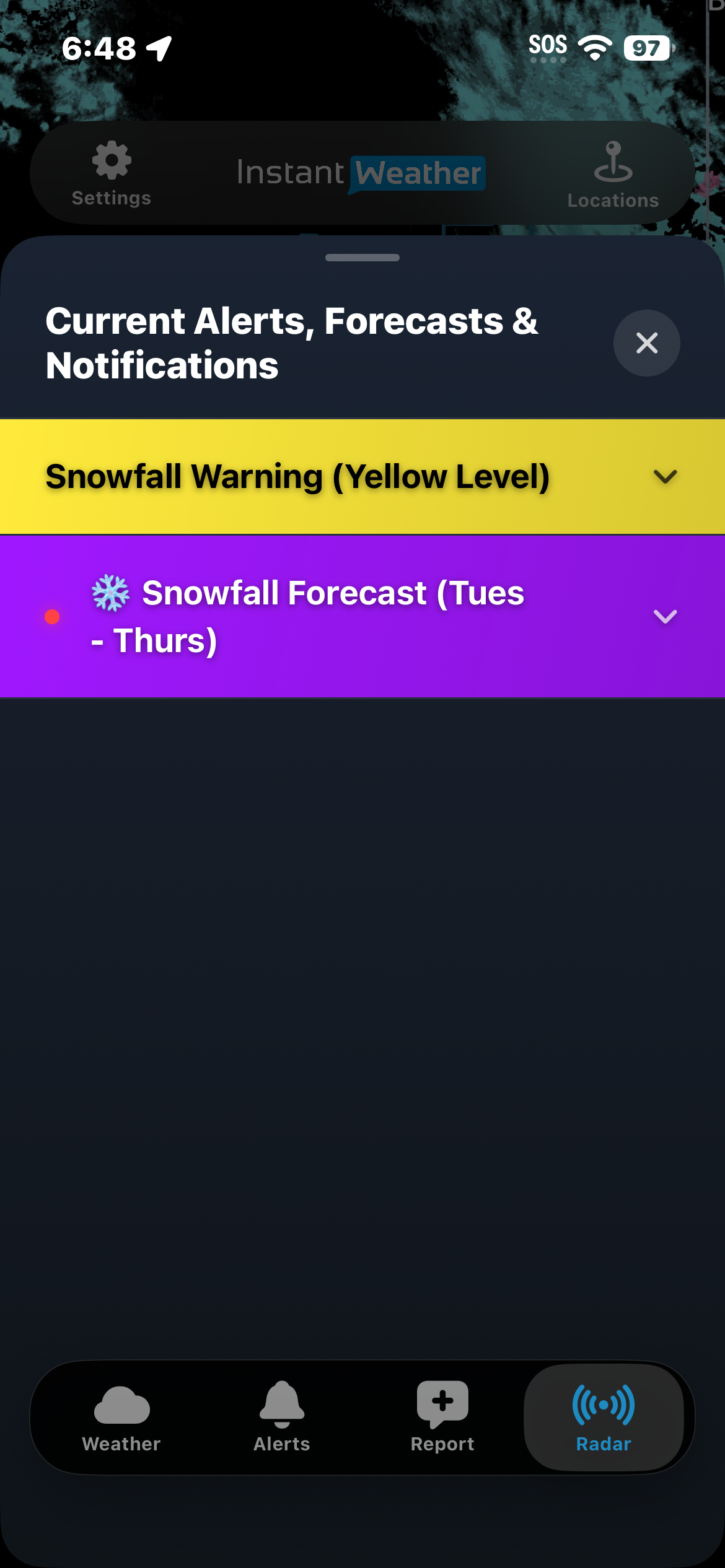
Official Weather Alert and Instant Weather Forecast
How Subscriptions Affect Radar
The amount of past and future radar available in Mosaic and Smooth Mosaic depends on your subscription.
Free: Past radar: 30 minutes, Future radar: 1.5 hours
Upgrade: Past radar: 30 minutes, Future radar: 12 hours
Extended: Past radar: 2 hours, Future radar: 48 hours
IW Pro: Past radar: 2 hours, Future radar: 48 hours
Raw Mosaic provides approximately three hours of past radar and one hour of future radar from Environment Canada.
IW Pro also includes a separate advanced radar suite with additional features for more detailed weather analysis.
The exact times available on the timeline may vary depending on radar data availability and updates.
Tips for Using Radar
Use Smooth Mosaic if you prefer a more continuous radar animation.
Use Raw Mosaic to examine precipitation intensity using Environment Canada's radar imagery.
Check whether you are viewing past or future radar before interpreting precipitation movement.
Zoom in to examine weather approaching a particular location.
Enable weather alert and Instant Update outlines to identify areas affected by significant weather.
Tap an outlined area and then the (i) button to review additional information.
Refresh the radar to check for updated information.
Radar is one tool for monitoring weather conditions. During severe weather, always review official weather alerts and other available weather information.
Need Help?
If the radar is not loading or displaying as expected, try the following:
Update the app: Make sure you're using the latest version of Instant Weather from the Apple App Store or Google Play Store.
Refresh the radar: Tap the Refresh button to reload the radar data.
Restart the app: Close Instant Weather completely and reopen it.
Reinstall the app: If the problem continues, try deleting the app and reinstalling it from the Apple App Store or Google Play Store.
Note: Reinstalling may reset some app settings or locally stored information.
If you're still experiencing problems, please contact Instant Weather Support at help@InstantWeather.ca.
Include your device type, app version, selected radar type and a description of the issue. Screenshots are also helpful.
Last updated: November 10, 2026