London Area Could Get Hammered by Intense Snow Squall on Thursday With Locally Up to 50-75cm of Snow
/As the Alberta Clipper that brought widespread snowfall to Southern Ontario exits late Wednesday, snow squalls are set to return to the snowbelt regions. Unfortunately, the areas that were buried earlier this week will once again bear the brunt of this lake effect activity.
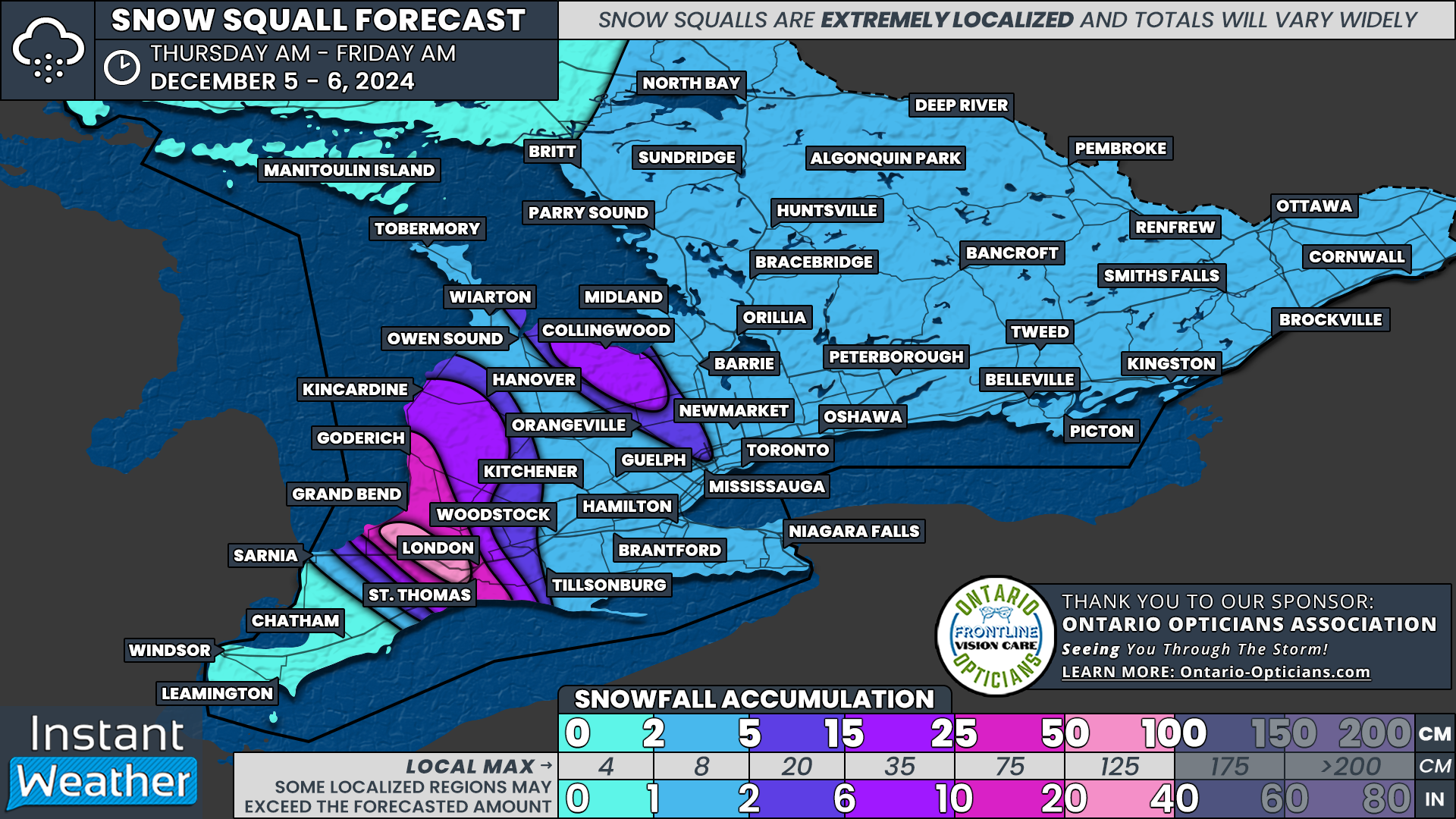
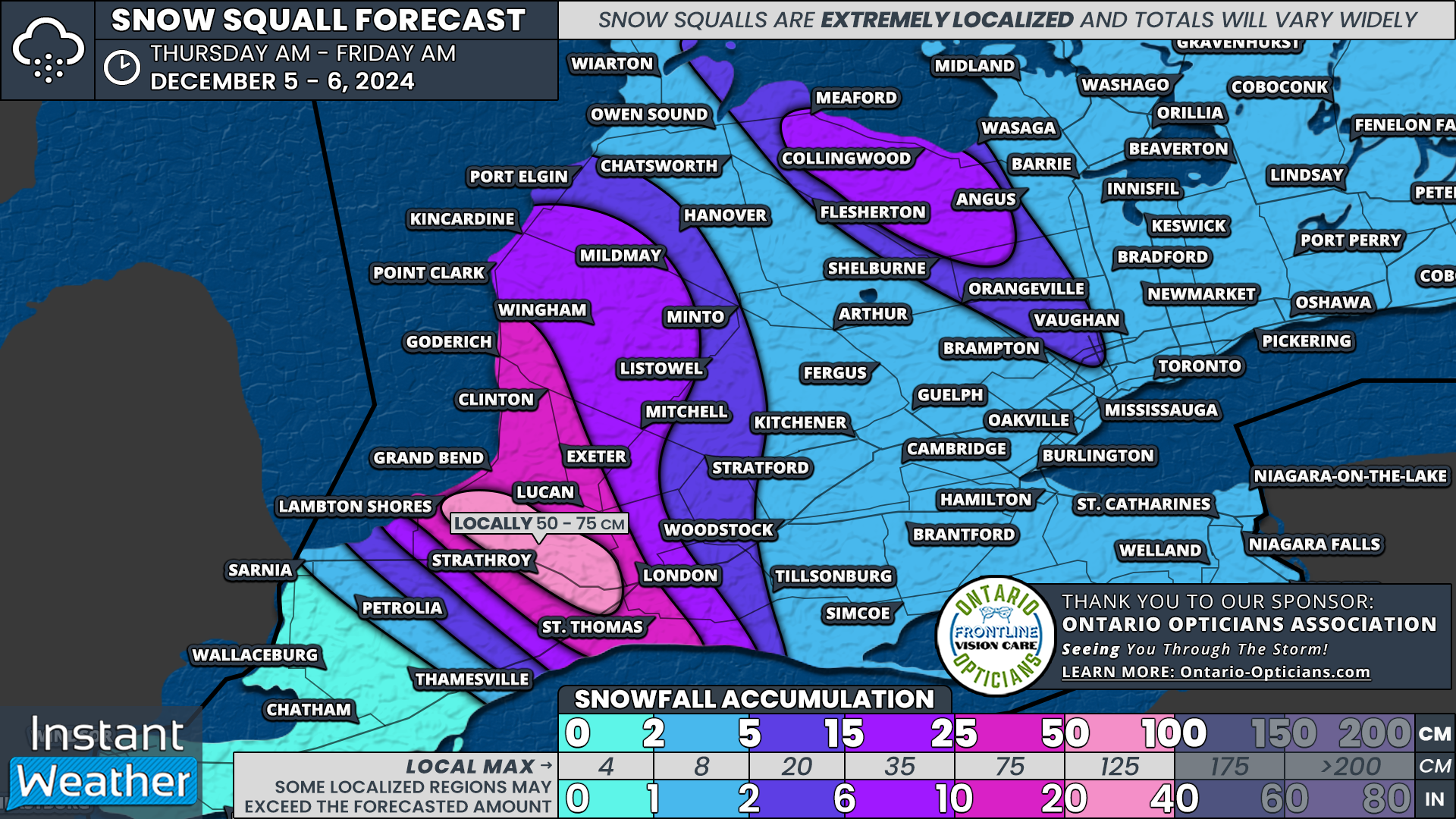
Locations just north and west of London appear to be in the bullseye, with the potential for 50 to 75 cm of fresh snowfall accumulation by the end of Thursday.
PRECIPITATION TYPE - MAP FROM WEATHERBELL
Lake effect activity is expected to begin organizing overnight and into early Thursday morning along the southern shorelines of Lake Huron and Georgian Bay. Current forecasts suggest this activity will consolidate into a few well-defined snow squalls by late morning or early afternoon.
The most intense squall is projected to form off the southeastern shoreline of Lake Huron, extending from Port Franks through Strathroy and into the west end of London. Additional streamers could impact areas further inland and along the eastern Lake Huron shoreline, stretching from Kincardine down to Grand Bend.
PRECIPITATION TYPE - MAP FROM WEATHERBELL
A separate squall will develop off Georgian Bay, spanning from Collingwood to Shelburne. Forecast models differ on the intensity of this squall, with some suggesting it could push far inland, potentially reaching parts of the Greater Toronto Area (GTA) just in time for the evening commute.
This scenario could bring a heavy burst of snow to the Hwy 400 corridor between Bradford and Vaughan, possibly extending to Mississauga and even the western parts of Toronto.
The primary concern with this event is that the squalls are unlikely to shift much throughout the day. Instead, they could remain stationary for over 12 hours, beginning Thursday morning and continuing into the late evening.
As seen in Muskoka over the weekend, stationary squalls can produce extreme snowfall rates of 10–15 cm per hour, quickly overwhelming plowing operations and making travel nearly impossible as highways are buried in snow.
Travel is strongly discouraged along the Lake Huron shoreline, particularly on Hwy 402 between London and Wyoming, during the day on Thursday and into the evening. Blizzard-like conditions, combined with rapid snowfall accumulation, will create dangerous and potentially life-threatening travel conditions.
The Georgian Bay squall is expected to diminish just after midnight, while the Lake Huron squall will gradually lift north of London during the pre-dawn hours on Friday. Additional lake effect snow is possible east of Lake Huron and Georgian Bay on Friday, though it remains unclear whether it will organize into significant squalls. We will provide updates in a separate forecast if substantial accumulation seems likely.
The most intense snowfall is expected to target a small area west of London, including Parkhill, Ailsa Craig, and Strathroy, where totals could exceed 50 cm and potentially reach 75 cm. It’s important to note that these higher totals will be very localized, as the squall is forecast to be quite narrow. The exact location of the heaviest accumulation will depend on where the squall sets up.
While the City of London is likely to avoid the worst of the snowfall, it isn’t entirely in the clear. The city’s west end could see totals ranging from 25 to 50 cm. A slight eastward shift in the squall could place London directly in its path, significantly increasing snowfall totals for the area.
Lower amounts are expected in London’s east end, which is likely to see between 10 and 20 cm. St. Thomas could also be affected, with snowfall potentially reaching 20–30 cm depending on how far inland the squall extends.
Other communities along the southeastern shoreline of Lake Huron, including Grand Bend, Lucan, Exeter, Clinton, and Goderich, are projected to receive 25–50 cm by the time the squalls diminish on Friday morning.
As is typical with snow squalls, snowfall gradients will be extremely sharp, and accumulation will drop off quickly outside the most affected areas. Locations such as Kincardine, Listowel, and Mitchell can expect totals of around 10–20 cm.
The Georgian Bay squall is anticipated to be less intense than its Lake Huron counterpart. Accumulations of 15–25 cm are expected for areas like Collingwood and Shelburne. If the squall extends into parts of the GTA, it could bring a quick 5–10 cm of snow, primarily affecting Brampton, Mississauga, and other areas in the western GTA.
Less than 5cm is expected for the rest of Southern Ontario.


