STORMY SUNDAY: Parts of Ontario Could Experience Damaging Wind Gusts & Flooding Risk This Weekend
/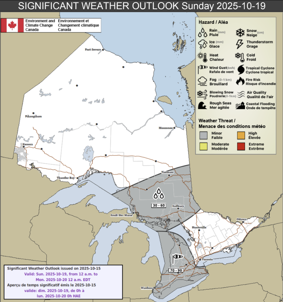
NOTE: YOU CAN CLICK ON THE MAP TO OPEN A ZOOMABLE IMAGE
Environment Canada has released its latest medium range forecast, highlighting the potential for 70-90km/h damaging wind gusts across Southwestern Ontario, the Niagara regions and western GTHA regions on Sunday, October 19th, 2025.
They also mention a rainfall risk for Northeastern Ontario with the potential for 30-60mm of accumulation that could cause isolated flooding.
If this trend continues towards the weekend, it’s certainly possible that the ‘minor’ risk will be increased to a ‘moderate’ risk but seeing as we’re still four days out, it makes sense that Environment Canada is keeping the risk at the minor level.
Environment Canada does have a specific explanation for minor risks and it is: “This weather event is potentially significant or of interest. Users should stay informed.”
NOTE: YOU CAN CLICK ON THE GRAPHIC ABOVE TO OPEN A ZOOMABLE IMAGE

NOTE: YOU CAN CLICK ON THE GRAPHIC ABOVE TO OPEN A ZOOMABLE IMAGE
💨 Southern Ontario

NOTE: YOU CAN CLICK ON THE GRAPHIC ABOVE TO OPEN A ZOOMABLE IMAGE
Environment Canada writes in their forecast for Southern Ontario:
“Strong southwesterly winds with gusts of 70 to 90 km/h are likely for areas near Lake Erie and portions of southwestern Ontario. Winds will shift to northwesterly with the passage of a cold front late in the day, with gusts up to 90 km/h possible. Confidence is low regarding the timing and strength of winds expected.”
They also break down the risks:
Hazard(s): Wind
Location: Southwestern Ontario and western portions of the Greater Golden Horseshoe.
Timing: Sunday
Impact(s): Broken tree branches and downed trees. Power outages likely.
Confidence: Low (1 out of 4)
Impact: Moderate (2 out of 4)
🌧️Northeastern Ontario
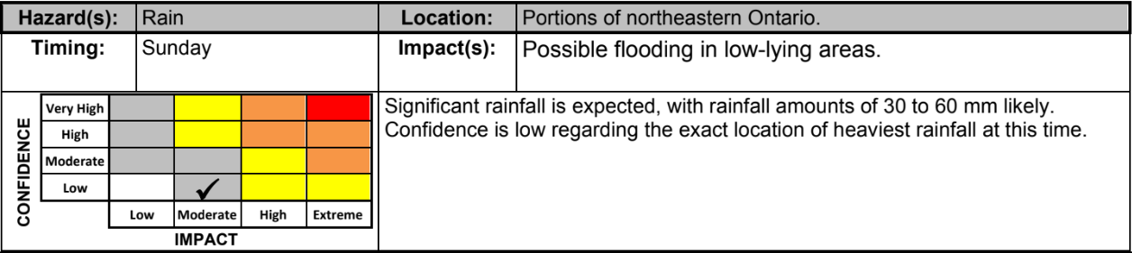
NOTE: YOU CAN CLICK ON THE GRAPHIC ABOVE TO OPEN A ZOOMABLE IMAGE
Here are Environment Canada’s details for the rainfall risk in Northeastern Ontario:
”Significant rainfall is expected, with rainfall amounts of 30 to 60 mm likely. Confidence is low regarding the exact location of heaviest rainfall at this time.”
They also break down the risks:
Hazard(s): Rain
Location: Portions of northeastern Ontario.
Timing: Sunday
Impact(s): Possible flooding in low-lying areas.
Confidence: Low (1 out of 4)
Impact: Moderate (2 out of 4)
🔎 Staying Safe and Prepared
As we move towards the winter months, it’s critical to stay informed! To keep a close eye on our latest forecasts and get notified of any alerts, download our free app Instant Weather, available on Apple and Android devices.
Take a moment to secure any loose outdoor items before the storms arrive. Things like patio furniture, trampolines, and garbage cans can become projectiles in strong winds.
If you're planning to be on the roads, be prepared for challenging driving conditions such as sudden downpours, significantly reduced visibility, and the possibility of water pooling on roadways, especially in areas expecting heavier rainfall.
Stay safe everyone and if it’s safe to do so, share your reports with half a million community members on our Facebook group called Ontario Storm Reports!
Disclaimer: These forecasts are issued by Environment Canada and typically published via their Twitter/X accounts. We receive these forecast via a daily email and often publish them to help inform our communities.


