Snow Squalls Could Bury Parts of Southern Ontario’s Snowbelt in Up to 50cm of Snow Early This Week
/
NOTE: YOU CAN CLICK ON THE MAP TO OPEN A ZOOMABLE IMAGE
As much of Southern Ontario cleans up after our first widespread snowfall of the season, Mother Nature is showing no signs of slowing down. The lake effect snow machine is roaring to life over Lake Huron and Georgian Bay as we kick off the second week of November.
Snow squalls have already developed south of Lake Huron late Sunday evening and are expected to strengthen through the night. We’re also anticipating some squall development along the southern shoreline of Georgian Bay, which should organize by Monday afternoon or evening.
Two main regions are likely to see the most intense activity. The first stretches between Sarnia and London, while the second includes areas south of Georgian Bay from Blue Mountain and Meaford toward the west of Barrie. Both zones could see heavy snow squalls lasting through to Tuesday morning.
While snowfall totals will vary significantly across short distances, confidence is increasing that the hardest hit areas could see as much as 25 to 50cm by the time the squalls taper off on Tuesday. Localized pockets may even exceed 50cm, depending on where the heaviest bands set up.
Road conditions are expected to deteriorate quickly in these regions, with road and highway closures likely late Monday and into early Tuesday when the most intense squalls occur. Travel should be avoided unless absolutely necessary, as these bands can produce sudden whiteouts, making it nearly impossible to see the road ahead.

ESTIMATED AIR TEMPS AROUND 1.5KM ABOVE GROUND - MAP FROM WEATHERBELL
This setup is being fueled by a rare November appearance of a mini “Polar Vortex” which is pulling a blast of Arctic air into Southern Ontario. This cold air is flooding the upper levels of the atmosphere and setting the stage for intense lake effect activity.
To put it simply, when forecasters talk about 850mb temperatures, we’re referring to the air temperature roughly 1.5 kilometres above the ground. This level helps forecasters understand how cold the air mass is higher up in the atmosphere, which is critical for predicting lake effect snow.
Over the next few days, 850mb temperatures are expected to plunge into the negative teens. Lake effect snow forms when there’s a large temperature difference between the lake surface and the air above it, generally 13°C or greater. With upper air temperatures between -10°C and -15°C and lake temperatures still above 10°C, that difference is more than 20°C, creating ideal conditions for lake effect snow to thrive.

hourly snowfall rates (cm) - MAP FROM WEATHERBELL
As of midnight, snow has already developed off the southern shores of Lake Huron, impacting the Sarnia region. So far, the bands have been disorganized and spread out, but that’s expected to change by late Monday morning as a stronger, more focused squall forms somewhere between London and Sarnia.
While the exact placement remains uncertain, areas near Petrolia and Strathroy appear most likely to be in the direct path. The band will likely shift through the day as wind directions fluctuate, leading to varying snow intensities across nearby towns.
hourly snowfall rates (cm) - MAP FROM WEATHERBELL
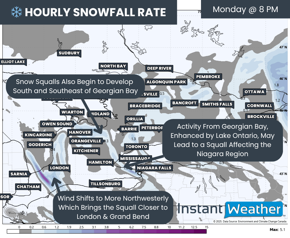
By Monday evening, things will really start to ramp up. The main squall off Lake Huron will likely push inland, with a more northwesterly wind direction steering it toward Grand Bend, Goderich and potentially the western edges of London. It’s still unclear if the squall will reach directly into London or remain just outside the city, but if it does, the heaviest snowfall will likely fall on the west side.
Meanwhile, snow squalls are expected to organize over Georgian Bay with heavy snow bands developing between Owen Sound and Barrie. There’s still some disagreement among models, with some focusing more on Wasaga Beach and Barrie while others favour a southern shoreline setup.
An interesting twist could occur if these Georgian Bay bands extend far enough inland to be enhanced by Lake Ontario. In that case, snow could reach into the western GTA and even the Niagara region, leading to sudden bursts of heavy snow if everything aligns.
hourly snowfall rates (cm) - MAP FROM WEATHERBELL
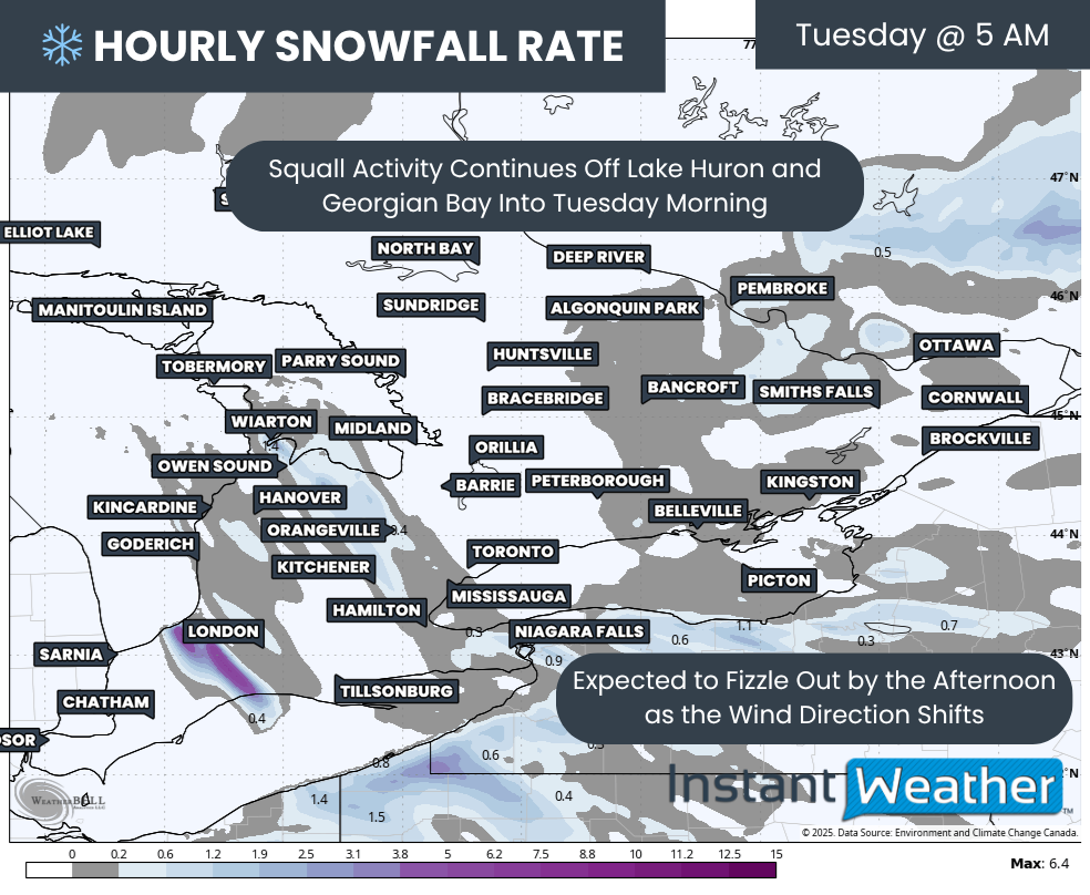
This lake effect activity is expected to persist overnight and into Tuesday morning, though the Georgian Bay bands should weaken slightly around sunrise. West of London, however, heavy snow could continue well into Tuesday morning before breaking apart as conditions become less favourable later in the day.
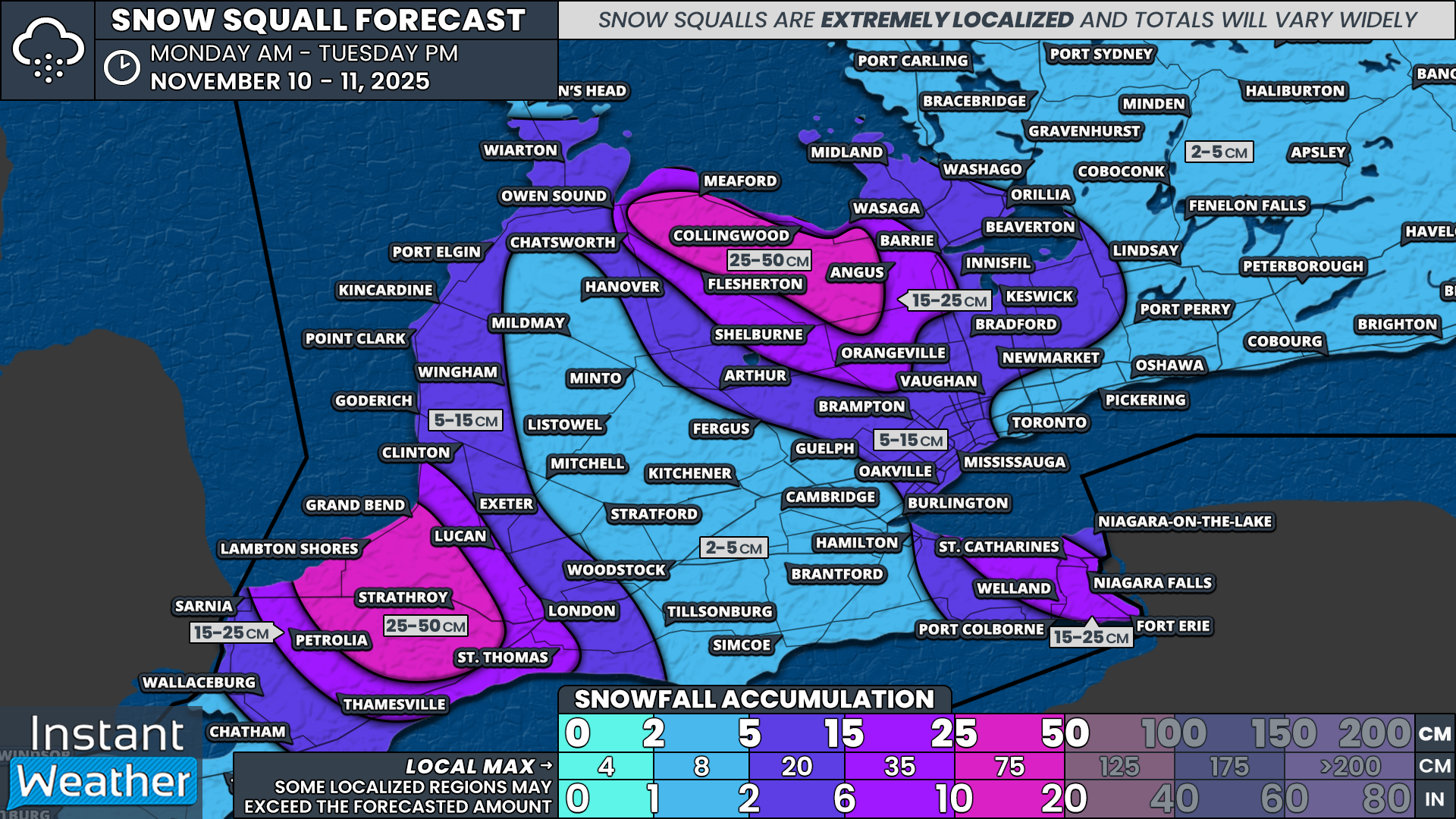
As always with lake effect snow, totals are extremely difficult to pinpoint. These narrow bands can stay locked over one community for hours while completely missing another just a few kilometres away. One person may end up shovelling half a metre of snow while someone nearby barely sees a dusting.
That said, two areas consistently stand out across the latest model runs. One includes Lambton Shores, Grand Bend and Strathroy, while the other covers the southern Georgian Bay shoreline and higher terrain around Blue Mountain. These regions could see totals ranging from 25 to 50cm by Tuesday.
Surrounding communities such as Petrolia, Thamesville, St. Thomas and Lucan, along with Orangeville, Shelburne and Flesherton, are more likely to see 15 to 25cm.
Both London and Barrie sit right on the edge between lighter and heavier accumulations. We currently have them in the 5 to 15cm or 15 to 25cm zones, depending on how far east the snow squalls extend.
Finally, the Niagara region remains uncertain. If the Georgian Bay squalls stretch far enough inland and connect with Lake Ontario, parts of the region could pick up over 15cm of additional snow.
Outside of these snowbelt regions, impacts will be much less significant. A few flurries and brief bursts of snow are possible as the squalls wobble, but most areas outside the direct lake effect zones should remain relatively calm through Tuesday.


