Snowy Sunday Sweeps Into Southern Ontario With First Widespread Snowfall of the Season
/
NOTE: YOU CAN CLICK ON THE MAP TO OPEN A ZOOMABLE IMAGE
While there has been a lot of uncertainty surrounding Southern Ontario’s first widespread snowfall event of the season, we’re finally starting to get a clearer picture of what will unfold on Sunday. After several model shifts over the past few days, the latest data is now coming into better alignment, giving us a more confident idea of how this system will behave.
A developing low-pressure system is expected to move in from the southwest late Saturday night, tracking across areas near Lake Erie through the day on Sunday. As it does, it will bring a broad swath of snow stretching from Windsor through the Golden Horseshoe and into Eastern Ontario. Snow is expected to last much of the day before gradually tapering off overnight.
At this stage, snowfall totals are expected to vary quite a bit across the region. The exact placement of the heaviest snow bands remains uncertain, and surface conditions will also play a big role. Since the ground is still relatively warm, some of the early snowfall may melt on contact before it can begin to accumulate, especially on roads and sidewalks.
In general, by Monday morning, snowfall totals are expected to range from around 5 to 10 cm across the Golden Horseshoe and into Eastern Ontario. Within those areas, localized pockets, particularly in Eastern Ontario, could pick up as much as 15 to 20 cm according to the latest model runs. Further north and west, across Central and Southwestern Ontario, amounts will be lower with less than 5 cm expected in most spots.
As the system departs, colder air will pour into Southern Ontario late Sunday night, sending temperatures well below freezing. Any slushy snow or water on roads, sidewalks, and driveways will freeze quickly overnight, which could create slick conditions for the Monday morning commute. Drivers should be prepared for icy patches, and there’s a decent chance of school bus cancellations in areas that see higher snowfall totals.
The colder air will also fire up the lake effect snow machine early next week. Model guidance suggests that an intense but narrow band of snow could form southeast of Lake Huron late Monday and continue into Tuesday. This could impact communities such as Grand Bend and London, where local snowfall totals could exceed 25 cm if the band remains stationary for an extended period.
PRECIP TYPE - MAP FROM WEATHERBELL
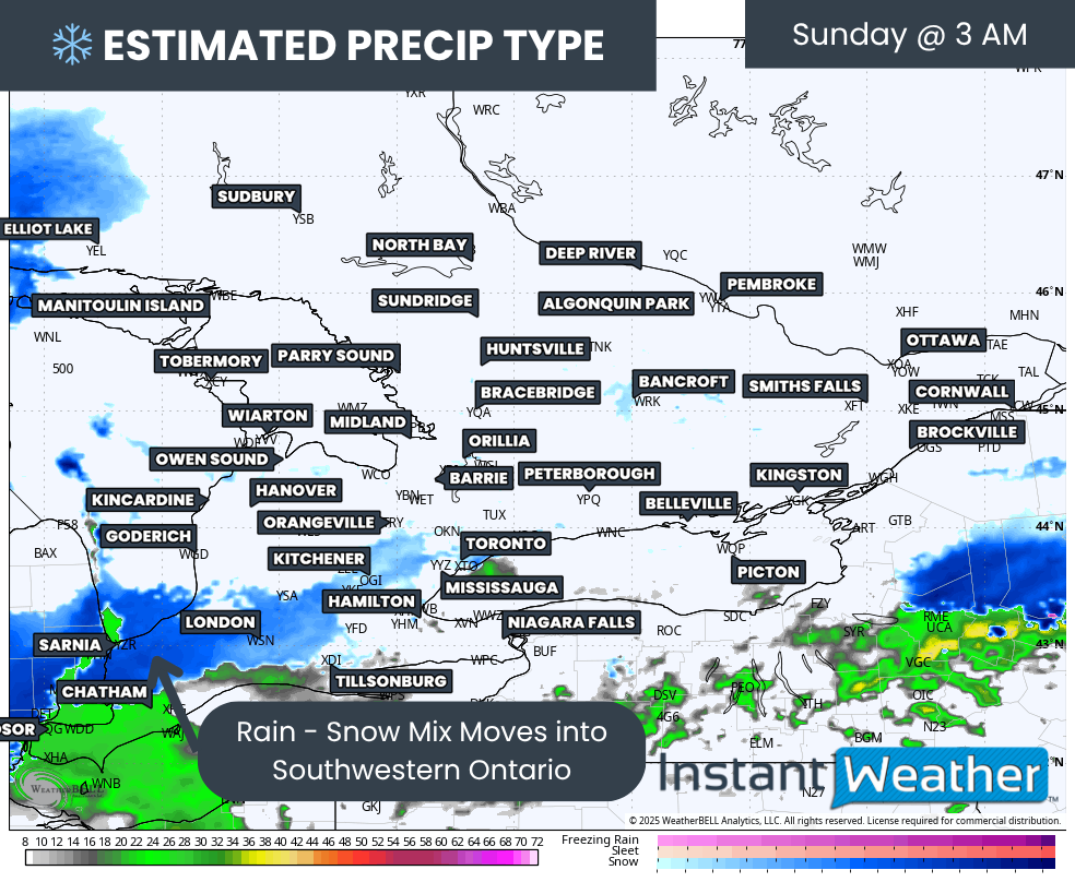
For timing, snow is expected to begin in Deep Southwestern Ontario shortly after midnight. Around Windsor and Chatham, it may even start as rain before transitioning to snow as temperatures drop closer to dawn.
PRECIP TYPE - MAP FROM WEATHERBELL
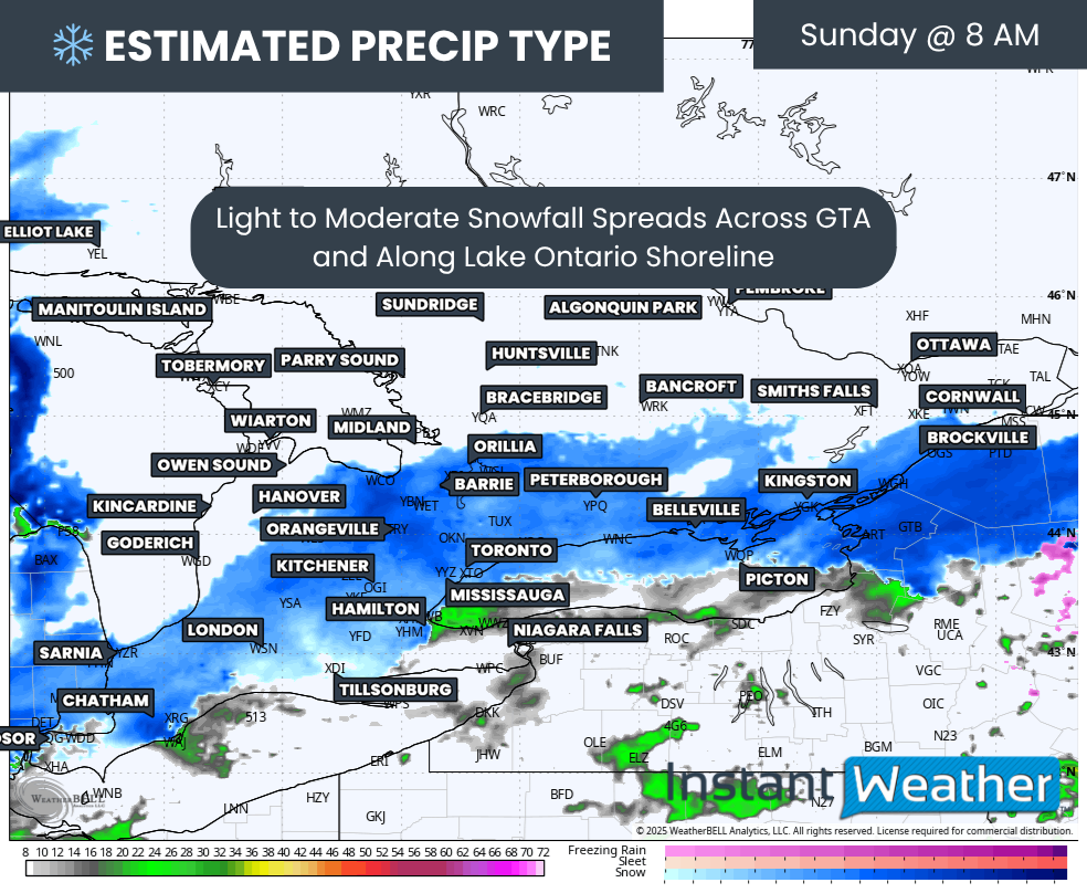
By late Sunday morning, the snow will have spread into the Golden Horseshoe, becoming heavier through the afternoon. In Eastern Ontario, snow will likely begin around Kingston early in the morning and reach the Ottawa area by midday.

hourly snowfall rates (cm) - MAP FROM WEATHERBELL
The heaviest snowfall rates across the Golden Horseshoe are expected from early to mid-afternoon, with some models projecting bursts of 2 to 4 cm per hour at times before tapering off toward the evening.
PRECIP TYPE - MAP FROM WEATHERBELL
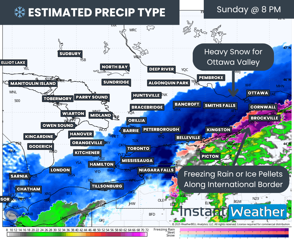
For Eastern Ontario, steady snow will continue through the afternoon, peaking after dinner before easing into scattered flurries overnight. With that timing, school bus cancellations are quite possible for parts of Eastern Ontario on Monday.
There are also some indications that freezing rain or ice pellets may mix in along the international border Sunday evening. Areas such as Kingston, Brockville, and Cornwall are most at risk for this brief mix, which could add an extra layer of slickness to untreated surfaces.
NOTE: YOU CAN CLICK ON THE MAP TO OPEN A ZOOMABLE IMAGE
While there is still some disagreement among the models on exactly where the heaviest snow will fall, the general expectation remains 5 to 10 cm along the Golden Horseshoe and into Eastern Ontario, with some locally higher amounts near 15 cm.
We’ve outlined portions of Eastern Ontario and the higher elevations of the Niagara region on our map with a dotted zone, representing areas that could overachieve and see closer to 20 cm. However, that outcome is far from certain.
Keep in mind that this is the first significant snowfall of the season, and with ground temperatures still above freezing, actual accumulation could vary from one street to the next. Some areas may see a quick coating, while others struggle to hold the snow through the day, especially near the lakeshores.
Elsewhere, Southwestern Ontario and much of Central Ontario should see lighter amounts, generally only a few centimetres, with some localized areas possibly reaching up to 8 cm. Regions like Grey-Bruce and the northern parts of Central Ontario will likely miss out on the heaviest snow this time, but that may not last long as lake effect activity ramps up early next week.

PRECIP TYPE - MAP FROM WEATHERBELL
As higher-resolution models continue to come into range, we’re getting a clearer idea of what the first snow squall event of the season could look like. Current projections suggest activity will develop on Monday, with a more organized squall forming by the evening.
This band may set up somewhere between Grand Bend and Kettle Point, extending inland, likely just west of the City of London. Additional bands may also develop off Georgian Bay, impacting areas around Meaford and Collingwood.
Communities caught under these narrow squalls could see impressive snowfall totals, while just a few kilometers away, grass may still be visible. We’ll continue to refine the details as the event approaches and will have a more specific forecast on who could see the most snow closer to Monday.
Overall, this marks the true start of the winter season across Southern Ontario, with several systems and lake effect events lining up behind this one. It’s a good time to check that your winter tires are ready, snow shovels are handy, and morning routines include a few extra minutes to clear off your car. Winter is here to stay.


