Snow Squalls Target the Grey-Bruce and Barrie Area Again With Locally Up to 50-100cm of Snow by Tuesday
/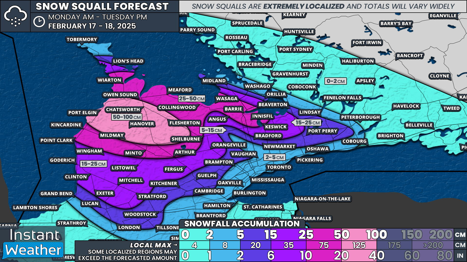
NOTE: YOU CAN CLICK ON THE MAP TO OPEN A ZOOMABLE IMAGE
Snow squalls are expected to become well-organized and intensify by Monday morning. One squall off Lake Huron will target southern Grey-Bruce, with periods of intense snowfall throughout the day. Thundersnow is even a possibility in this area.
Another squall will develop off the southeast shoreline of Georgian Bay, impacting parts of southern Simcoe County, including Wasaga Beach, Barrie, Angus, Innisfil, and Keswick.
These squalls will persist into the afternoon, shifting at times. The northern squall could push into Wiarton, extend across Georgian Bay, and come onshore near Barrie. Meanwhile, the southern squall off Lake Huron will stretch from Kincardine to Hanover and could push far inland, periodically bringing heavy snow into parts of the GTA.
By Monday night into Tuesday morning, the Lake Huron squall is expected to stall over southern Grey-Bruce, potentially leading to extreme snowfall accumulation. Wherever this band locks in, snowfall rates could reach an incredible 5-10 cm per hour. Some models suggest this squall could remain in place until Tuesday evening, somewhere between Owen Sound and Hanover.
The Georgian Bay squall may weaken somewhat after midnight but could persist into Tuesday. All snow squall activity should fizzle out by early Wednesday morning.
Projected Snowfall Totals:
Localized amounts near 100 cm are possible in Grey-Bruce, with hotspots likely near Port Elgin, Hanover, Chatsworth, and Flesherton. Not everyone in this zone will see these totals, but some areas will get buried.
25 to 50 cm is likely across the rest of Grey and Bruce counties, extending into northern Huron and Perth counties. This also includes areas along the southeastern shoreline of Georgian Bay, such as Collingwood, Wasaga Beach, and Barrie.
5 to 15 cm could extend into Kitchener, Guelph, Durham, and York as occasional bursts of heavy snow push outside the core snowbelt region.
The GTA may see light snow at times but is unlikely to receive more than 5 cm over the next two days.
Aside from the snow, we’re starting the week on a much colder note. If you’re heading outside for Family Day, be sure to bundle up—wind chills in the -20s are expected on Monday.
Stay safe and stay warm!


