Strongest Snowstorm in Years to Bury Southern Ontario in Up to 50cm of Snow on Sunday
/
NOTE: YOU CAN CLICK ON THE MAP TO OPEN A ZOOMABLE IMAGE
Brace yourself, Southern Ontario! One of the biggest snowfalls in recent years is on the horizon for many parts of the region—excluding the usual snowbelt areas. This includes major cities like Toronto, Kingston, and Ottawa, which have largely dodged significant snowstorms over the past few years due to milder winters.
That streak ended earlier this week with the first storm in this parade of systems, dropping a widespread 20 cm or more across Southern Ontario. However, that system could pale in comparison to what’s coming next. This stronger storm is likely to bring 30 cm or more to a large portion of the region throughout Sunday.
As of Saturday afternoon, the first round of snow has already arrived, bringing steady snowfall from Southwestern Ontario into the Golden Horseshoe. This initial wave will be just the beginning, with up to 10 to 15 cm expected by the end of the day.
The second and much more intense round of precipitation will begin early Sunday morning as the system taps into tropical Gulf moisture and directs it straight into the Great Lakes region.
By morning and into the afternoon, conditions will deteriorate rapidly, with snowfall rates reaching 4 to 8 cm per hour. When combined with moderately strong wind gusts, this will lead to widespread blowing snow, significantly reduced visibility, and even localized blizzard conditions.
By the time the snow begins to taper off late Sunday, widespread totals of 30 to 50 cm are expected across Central and Eastern Ontario, extending into the Greater Toronto Area. The hardest-hit areas could even exceed 50 cm, particularly in Eastern Ontario, where elevation may enhance accumulation. Meanwhile, locations along the Lake Erie shoreline, including Windsor, Niagara, and Chatham, may see lower snowfall totals due to potential mixing with freezing rain or ice pellets.

PRECIPITATION TYPE - MAP FROM WEATHERBELL
The first round of snow will continue steadily across Southern Ontario through Saturday evening and past midnight, with heavier snowfall targeting the Golden Horseshoe and the southern portions of Central and Eastern Ontario.
At the same time, the second round of snow will be rapidly developing south of the Great Lakes, forming over Indiana, Kentucky, and Ohio. This storm will strengthen quickly as it begins pulling in moisture from the Gulf of Mexico, which is also fueling severe thunderstorms across the southern U.S.
While there may be a brief lull overnight, don’t let it fool you—the worst is still ahead. The heaviest snowfall will begin to push into Southwestern Ontario before sunrise, bringing a rapid increase in snowfall rates from 1 to 2 cm per hour earlier in the night to 2 to 4 cm per hour by the early morning.
As the system intensifies, hourly rates of 4 to 6 cm—potentially even higher in the strongest bands—are expected. Road conditions will deteriorate quickly, with significantly reduced visibility and heavy blowing snow making travel extremely hazardous.

PRECIPITATION TYPE - MAP FROM WEATHERBELL
Most areas will remain on the snowy side of this system, but there is some uncertainty regarding how far north a warm layer could push. This could lead to a brief period of ice pellets or freezing rain in areas along the Lake Erie shoreline, including Windsor, Leamington, Chatham, St. Thomas, Tillsonburg, Hamilton, and Niagara Falls.

NOTE: YOU CAN CLICK ON THE MAP TO OPEN A ZOOMABLE IMAGE
While significant freezing rain is not expected, some minor ice accretion of a few millimetres could occur, particularly right along the shoreline.

PRECIPITATION TYPE - MAP FROM WEATHERBELL
By early to mid-morning Sunday, the storm’s intensity will peak across Southwestern Ontario and the GTA, with snowfall rates reaching 4 to 6 cm per hour in many areas. In the strongest bands, these rates could climb even higher, creating whiteout conditions.
Wind gusts of 40 to 60 km/h will further reduce visibility, and there is even the possibility of thundersnow as some of these snow bands intensify.
Meanwhile, areas farther north, including regions around Lake Simcoe, Peterborough, and into the Ottawa Valley, will begin to see snowfall intensities climb to 1 to 2 cm per hour, eventually reaching 5 to 10 cm per hour by the early afternoon

HOURLY SNOWFALL RATE/intensity - MAP FROM WEATHERBELL
The later part of Sunday morning after sunrise will see the worst conditions through Southwestern Ontario into the GTA as snowfall rates increase even further towards 4 to 6cm and possibility even higher in the strongest pockets of snow.
This snow will also be accompanied by increasing wind gusts near 40 to 60 km/h leading to blowing snow and blizzard conditions. Don’t be surprised to see some thundersnow during the morning as these bands of snow will be quite strong and could produce some lightning as they move through the region.
Snowfall intensity will also gradually increase through Central and Eastern Ontario with hourly snowfall rates reaching 1-2cm per hour around Lake Simcoe through Peterbough and into the Ottawa Valley.

HOURLY SNOWFALL RATE/intensity - MAP FROM WEATHERBELL
As the system continues to push eastward, the most intense snowfall rates will shift into Central and Eastern Ontario. This is when travel will become nearly impossible in these areas as plows struggle to keep up with the rapid accumulation.
For Southwestern Ontario and the GTA, conditions will begin to improve slightly in the afternoon as the heaviest snow moves east. However, steady snowfall of 1 to 3 cm per hour will continue through much of the afternoon, with strong winds still blowing around earlier accumulations and keeping visibility low.
Snow will gradually taper off across Central and Eastern Ontario by Sunday evening, but blowing snow will remain a significant issue overnight. Travel will remain difficult even after the snowfall ends, particularly in areas with open terrain where drifting will be an issue.
By Monday, conditions should improve, but significantly colder air will move in. If possible, clearing snow on Sunday before temperatures drop is strongly recommended, as the snow will become much heavier to shovel once it settles and freezes.

ESTIMATED WIND GUSTS - MAP FROM WEATHERBELL
The strongest wind gusts will be found in Eastern Ontario, peaking during the early to mid-afternoon. Widespread gusts of 50 to 70 km/h are expected, with some areas, particularly around Ottawa and to the east, possibly seeing gusts near 80 km/h.
In comparison, the rest of Southern Ontario, including the Golden Horseshoe, will experience gusts of 40 to 60 km/h, while Southwestern Ontario will likely see gusts under 40 km/h.

NOTE: YOU CAN CLICK ON THE MAP TO OPEN A ZOOMABLE IMAGE
These wind speeds combined with the extreme snowfall rates expected across Eastern Ontario will almost certainly lead to blizzard conditions.
For a storm to meet the official criteria for a blizzard, winds of 40 km/h or greater must cause widespread reductions in visibility to 400 meters or less due to blowing and falling snow for at least four consecutive hours.
Based on current model data, it is highly likely that visibility will remain near zero for at least six hours from late morning to early/mid-afternoon in many parts of Eastern Ontario, surpassing the official blizzard threshold.
While it remains uncertain whether areas such as the GTA, Lake Simcoe, and Muskoka will officially reach blizzard criteria, blowing snow will still cause significant travel disruptions regardless of classification.
Regardless of whether your area officially meets blizzard criteria, this storm will create extremely dangerous travel conditions across much of Southern Ontario throughout Sunday.
Roads will become impassable at times, and even major highways will be difficult to navigate. Plows will struggle to keep up with the rapid accumulation, making travel nearly impossible in the worst-hit areas. If you don’t absolutely need to be on the roads, it is strongly advised to stay home.

NOTE: YOU CAN CLICK ON THE MAP TO OPEN A ZOOMABLE IMAGE
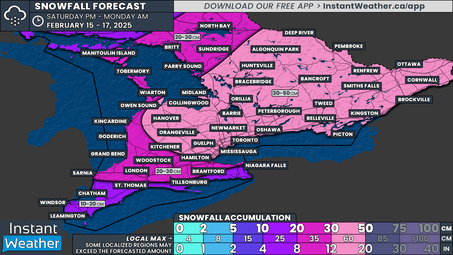
By the time the storm ends, the highest snowfall totals will be found across Central and Eastern Ontario, extending into portions of the GTA, with widespread accumulations ranging from 30 to 50 cm. Some areas, particularly in Eastern Ontario near Ottawa and through higher elevations to the west, could exceed 50 cm.
Regions around Lake Simcoe and the northern GTA will likely end up with 30 to 40 cm, though locally higher amounts are possible in areas such as the Dundalk Highlands. The Hamilton region and western GTA may see slightly lower totals, around 20 to 30 cm, due to the potential for ice pellets mixing in at times.
Southwestern Ontario, particularly along the Lake Huron shoreline, will see slightly less snowfall, with totals ranging from 20 to 30 cm. This includes areas such as Sarnia, London, Goderich, Grey-Bruce, Parry Sound, and North Bay. However, if the system strengthens earlier than expected, some of these locations could still exceed 30 cm.
Meanwhile, the lowest totals will be found along the Lake Erie shoreline, including Windsor, Chatham, and the Niagara region, where snowfall will range from 10 to 20 cm.
Looking ahead, colder temperatures are expected to settle into Southern Ontario by Monday. It would be wise to clear as much snow as possible on Sunday before the deep freeze sets in, as the snow will become significantly harder to move once temperatures drop.
Additionally, this colder air may trigger a resurgence of lake-effect snow early next week, which could lead to further significant snowfall accumulations in the typical snowbelt regions around Lake Huron and Georgian Bay. More details on that will come in a separate forecast.
This storm will be a major event, and conditions will be dangerous. If possible, stay home and avoid travel. We will continue to monitor the latest data and provide updates as needed. Stay safe!


