Southern Ontario to Kick Off Summer This Weekend With Significant Severe Risk and Tornado Threat on Saturday; Sizzling Heat Near 40°C on Sunday
/

NOTE: YOU CAN CLICK ON THE MAP TO OPEN A ZOOMABLE IMAGE
Summer officially arrived late Friday night with the summer solstice, and it looks like Mother Nature isn’t wasting any time making it feel like summer across Southern Ontario. A multi-day heat wave is on the way, bringing the potential for record-breaking temperatures starting Sunday and continuing into early next week.
But before the heat sets in, we’re looking at what could easily be our strongest and most widespread severe weather threat of the season so far on Saturday. There are a lot of factors at play that make this a classic ‘boom or bust’ setup, which we’ll break down below.
There’s high confidence in a potent storm environment stretching across much of Southern Ontario. The big wildcard, however, is whether storms will actually develop to take advantage of all that energy. If they do, they could bring very large hail, destructive wind gusts, and possibly even a couple of tornadoes.
What’s especially concerning is that the storm environment doesn’t fade away after sunset like it typically does. In fact, it remains quite strong through the overnight and into Sunday morning, which could support a nocturnal line of storms with widespread damaging wind potential.
Once the severe risk passes, intense heat begins to build. Temperatures will soar well into the 30s by Sunday, with humidex values making it feel closer to the 40s. The heat continues Monday and Tuesday, with some relief expected midweek. That said, it’ll likely stay warm into the end of June and possibly early July.

A key ingredient in Saturday’s severe weather threat is already unfolding over North Dakota early Saturday morning. An intense line of storms, known as a “derecho” (a fast-moving complex of severe thunderstorms that can produce widespread wind damage), is sweeping through the northern Plains.
This system is producing destructive wind gusts of over 150 km/h along with several tornadoes and has already left damage in its wake. It’s expected to continue tracking eastward into the Great Lakes region through the day.

SIMULATED RADAR - MAP FROM WEATHERBELL
So what does that mean for Southern Ontario?
Derechos are known to travel long distances, and current model guidance suggests this one could follow a path toward Northeastern Ontario. Areas near the U.S. border, including Sault Ste. Marie and Elliot Lake, could be affected by the remnants of this system Sunday morning.
There’s still some uncertainty around how strong the system will be by the time it reaches Ontario. Forecast models often struggle with capturing the evolution and intensity of derechos, so the possibility that this one is being underestimated shouldn’t be ignored.

SIMULATED RADAR - MAP FROM WEATHERBELL
The projected track of what’s left of this potentially decaying derecho places it crossing Lake Huron and Georgian Bay into Central Ontario sometime Saturday afternoon.
If it maintains strength, it could bring damaging wind gusts, hail up to the size of toonies and maybe even an isolated tornado. But this could just be the first of multiple storm rounds.
Some models are also hinting at additional isolated storm development around Elliot Lake and Sudbury in the wake of the earlier line. That suggests the atmosphere could quickly recharge, although it’s still unclear how widespread any new storms would be.

ESTIMATED ENVIRONMENT FOR TORNADOES - MAP FROM WEATHERBELL
As we move into the late afternoon and evening hours on Saturday, the storm environment really ramps up. One of the key indicators we look at, the Significant Tornado Parameter, is literally off the charts in some areas, particularly near the Lake Huron shoreline and into Georgian Bay.
Here’s the catch, though: storms need to develop in this environment to take advantage of it. If they do, they could rapidly become severe, with the potential for all hazards. That includes large hail (possibly golf ball-sized or bigger), destructive winds over 100 km/h, and tornadoes.

SIMULATED RADAR - MAP FROM WEATHERBELL
Looking at what one model is simulating, there’s a notable lack of storms in the highest risk areas around Lake Huron. Instead, storms appear to fire up along a line from Sudbury to Parry Sound through Muskoka, just northeast of the most primed environment. These storms could still be strong and bring similar hazards.
It’s worth noting that models may be underdoing storm development in Southwestern Ontario. That’s something we’ll need to monitor in real time. If nothing happens in Southwestern Ontario, it could end up being a ‘bust’ - which would be good news for those who aren’t fans of severe storms.

ESTIMATED ENVIRONMENT FOR TORNADOES - MAP FROM WEATHERBELL
Typically, severe weather threats wind down after sunset as daytime heating fades. But in this case, models are suggesting the environment will remain unusually supportive of storm activity well into the overnight hours and early Sunday.
There’s even the potential that a new line of storms forms north of Georgian Bay and sweeps southeast through Southern Ontario overnight. If this happens, it could evolve into another derecho-type system - similar to the one seen Friday night in North Dakota.
Forecasting derechos is notoriously difficult, as models often fail to capture their full strength and endurance. While nothing is certain, this setup definitely has the ingredients to support a nocturnal derecho-type event.
If this scenario plays out, we could see widespread wind damage across Central and Eastern Ontario, possibly extending into parts of Southwestern Ontario and the Golden Horseshoe.

NOTE: YOU CAN CLICK ON THE MAP TO OPEN A ZOOMABLE IMAGE

This is a very tricky forecast, and while we've gone with a ‘significant’ (level 4 out of 5) risk, that doesn’t mean everyone will see storms. The risk will come in waves, and some areas may be completely missed.
That said, the potential severity of any storms that do form justifies this level of concern. We’re talking about the possibility of golf ball-sized hail or larger, destructive wind gusts (possibly from a derecho), and a few tornadoes. The tornado risk will largely depend on storm structure—more linear setups will favour damaging wind, while discrete supercells could increase the tornado threat.
The highest severe risk covers areas around Georgian Bay including Sault Ste. Marie, Elliot Lake, Manitoulin Island, Britt, and into Central Ontario such as Muskoka, Simcoe County and Bancroft.
A broader ‘strong’ risk zone includes much of Central and Eastern Ontario, the northern portions of Southwestern Ontario, and the Greater Toronto Area.
Meanwhile, areas like London, Kitchener, Hamilton and the Niagara region fall into the widespread severe risk category.
For once, Deep Southwestern Ontario may dodge the worst of the storms. Windsor, Chatham and Sarnia are currently in the isolated severe risk zone. While a stray storm can’t be ruled out, most of that region looks to stay quiet Saturday.
There may be another round of severe weather on Sunday afternoon and evening, but confidence in the details is still low. Eastern Ontario may be favoured, but we’ll refine that forecast once Saturday plays out.

NOTE: YOU CAN CLICK ON THE MAP TO OPEN A ZOOMABLE IMAGE
Sunday marks the beginning of an extended stretch of dangerously hot temperatures. The most intense heat is expected across Deep Southwestern Ontario into the Golden Horseshoe.
Areas like Windsor, Sarnia, London, Hamilton, Kitchener and Toronto could see daytime highs between 35°C and 40°C. With humidity, it will feel like the mid-40s in many spots.
Locations near Lake Ontario, Lake Erie, Lake Huron and Georgian Bay will be 5 to 10 degrees cooler, but it doesn’t take much distance inland to hit the oppressive heat.
Elsewhere in Southern Ontario, expect highs in the low to mid-30s with humidex values near 40°C.
Heat Safety Tips:
Stay hydrated and avoid strenuous outdoor activity during peak heat hours.
Check in on vulnerable individuals, including the elderly, young children and those with health conditions.
Never leave pets or people in parked vehicles.
Use fans or air conditioning when possible and find shade or cooling centres if needed.
SOURCE: ECCC
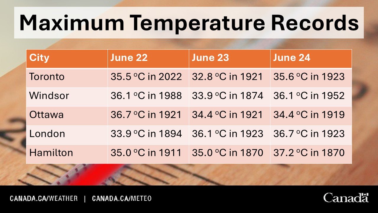
There’s a good chance many locations will break temperature records going as far back as the 1800s over the next few days.
According to Environment Canada, record highs in cities like Toronto, Windsor, Ottawa, London and Hamilton are in the mid to upper 30s for Sunday, Monday and Tuesday. Based on the current forecast, some of these records may fall.

NOTE: YOU CAN CLICK ON THE MAP TO OPEN A ZOOMABLE IMAGE
Monday brings more of the same, with extreme heat expanding into parts of Central and Eastern Ontario in addition to Southwestern Ontario and the GTA.
Once again, humidex values will push into the 40s, making it feel extremely uncomfortable and even dangerous for some.
Tuesday will still be hot, but may be slightly cooler compared to Monday. Some relief is on the way by Wednesday, although temperatures will likely stay warm overall.


