‘Snow Day’ Forecast: Flash Freeze Risk Brings Slight Chance of School Bus Cancellations in Parts of Southern Ontario on Wednesday
/Enter to Win a 7-Night Cruise for 2 with Celebrity Cruises, Including Airfare - Select Patricia Bootsma as your travel consultant
Rapidly plunging temperatures followed by the development of snow squall activity are expected across Southern Ontario throughout the day on Wednesday, creating a potentially tricky setup when it comes to school transportation.
As a strong cold front sweeps across the region beginning Wednesday morning, temperatures are expected to fall sharply in a short period of time. In some areas, readings could drop from a few degrees above freezing to well below minus 10 degrees within just a few hours. This raises the risk of a flash freeze, particularly on untreated roads, sidewalks and rural routes.
Because of this flash freeze potential, there is a possibility that some school boards may choose to cancel buses, especially in rural areas that are more sensitive to icy conditions. These boards rely heavily on extensive backroad routes, where surfaces can quickly become dangerous once temperatures drop below freezing.
One of the complicating factors with this setup is timing. In many parts of Southern Ontario, temperatures are not expected to begin falling sharply until the late morning or early afternoon. That means any cancellations would need to be made proactively, based on expected conditions later in the day, rather than what is occurring at the time of the morning bus run. Historically, this type of proactive decision-making can vary significantly from one school board to another.
If Environment Canada issues a flash freeze warning by early Wednesday morning, the probability of cancellations would increase fairly rapidly. Flash freeze warnings tend to carry more weight with school boards, as they highlight a rapid deterioration in road conditions that can catch drivers off guard.
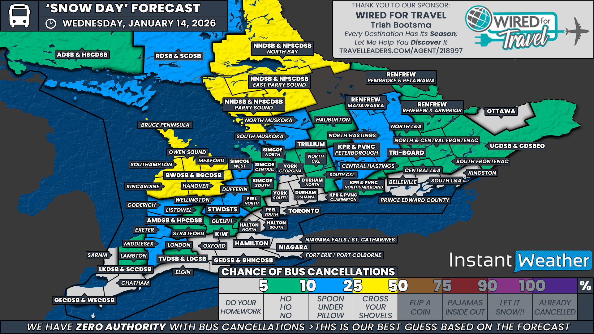
At this time, the highest chance for bus cancellations includes all regions covered by the Bluewater District School Board and the Near North District School Board. We have assigned these areas a slight chance, around 25 percent. These boards are expected to be among the first to experience the temperature drop as the cold front pushes in from the northwest.
Current indications suggest the front could arrive as early as 4 to 6 AM in these areas, which increases the likelihood that icy conditions could already be developing during the morning commute. In addition, Environment Canada snow squall watches mentioning squalls developing later in the day may give the Bluewater District School Board additional reason to consider cancellations.
Across the rest of Southwestern, Central and Eastern Ontario, we have gone with a widespread low to very low chance of school bus cancellations, generally in the 5 to 10 percent range. The slightly higher end of that range is focused on regions under snow squall watches or rural school boards that historically respond more cautiously to flash freeze situations.
At this point, we do not believe the snow squall watches alone will be enough to prompt cancellations on Wednesday, as the bulk of the squall activity is expected to begin after the school day has ended. However, this setup does raise concerns heading into Thursday, when snow squalls are expected to ramp up late Wednesday and continue into the following day.
For the remainder of Southern Ontario, the chance of school bus cancellations remains under 5 percent. Weather conditions in these areas are not expected to reach the threshold that typically leads to cancellations, and most school boards should be able to operate normally on Wednesday.
Disclaimer: Instant Weather has zero authority when it comes to bus and school closures.
It is completely up to the school boards, bus companies, local authorities, and parents to decide what is best for their children. This is our best guess based on our forecast.


