‘Snow Day’ Forecast: Major Snowstorm Almost Certain to Cancel School Buses in Much of Southern Ontario on Thursday
/For an updated list of school bus cancellations & school closures, please visit our live article: https://instantweatherinc.com/article/2026/1/15/bus-cancellations
Enter to Win a 7-Night Cruise for 2 with Celebrity Cruises, Including Airfare - Select Patricia Bootsma as your travel consultant
A last-minute shift in forecast models has placed much of Southern Ontario in the crosshairs of a prolonged snowstorm expected to begin Wednesday evening and continue through much of Thursday. This system has the potential to be impactful, with snowfall totals exceeding 20 cm in some areas by the time it winds down late Thursday.
Environment Canada has responded by issuing widespread snowfall warnings stretching from parts of Eastern and Central Ontario through the Golden Horseshoe. At the same time, snow squall warnings have been issued for areas south of Lake Huron and Georgian Bay, adding another layer of complexity to this already active setup.
In addition to the snow, very cold Arctic air is expected to surge into Southern Ontario overnight into Thursday morning. Wind chills could approach minus 30 degrees in some areas, especially during the early morning hours.
This combination of heavy snow, blowing snow and dangerous cold is almost certain to disrupt travel and will very likely lead to widespread school bus cancellations. In some regions, school closures may also need to be considered.
The highest confidence for a snow day is found across the more rural school boards that are typically the most sensitive to adverse winter weather. With active snowfall warnings in place and significant accumulation expected, thresholds will almost certainly be met.
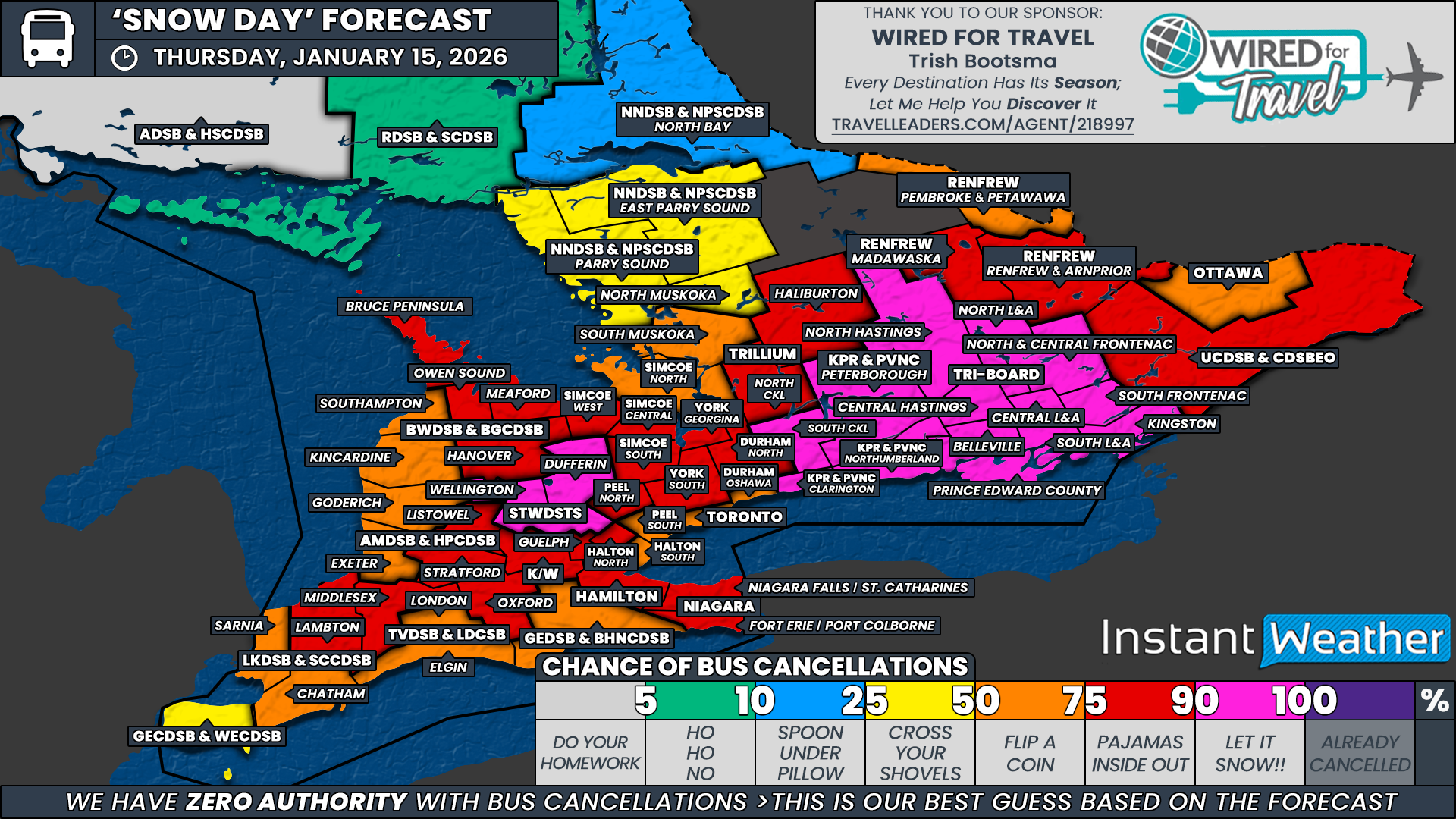
We have assigned a 90 percent chance to all areas covered by Tri-Board Student Transportation Services, all of Kawartha Pine Ridge District School Board, the South Kawartha Lakes region under the Trillium Lakelands District School Board, and Wellington and Dufferin counties within the Upper Grand District School Board.
A much broader area falls into the strong likelihood category, with a 75 percent chance of a snow day. This includes the Upper Canada District School Board and the Renfrew County District School Board, Haliburton County and North Kawartha Lakes under TLDSB, North Durham within the Durham District School Board, York Region District School Board, the Simcoe Central, Simcoe South and Simcoe West zones under the Simcoe County District School Board, northern Peel Region, northern Halton, Hamilton-Wentworth, Niagara Region, Guelph within the Upper Grand District School Board, Waterloo Region, Oxford County and Middlesex County under the Thames Valley District School Board, Lambton County within the Lambton Kent District School Board, Perth County under the Avon Maitland District School Board, and the Hanover, Meaford, Owen Sound and Bruce Peninsula areas within the Bluewater District School Board.
While we expect most of these school boards to cancel buses, there remains a small chance that a few could attempt to operate if snowfall rates are lighter than expected early Thursday morning. That said, confidence remains high that cancellations will be widespread within this zone.
For more urban school boards, confidence becomes less certain. Areas including Ottawa under the Ottawa Student Transportation Authority, southern Durham Region within the Durham District School Board, Toronto District School Board, southern Peel Region, southern Halton, and the Grand Erie District School Board have been assigned a 50 percent chance. The snowfall amounts currently mentioned in Environment Canada alerts sit right on the threshold that typically prompts cancellations for these boards. Some forecast guidance suggests totals could exceed what is currently advertised, and if that materializes, cancellations would become more likely in these areas.
Other regions sitting firmly in the toss-up category include Simcoe North, South Muskoka under the Trillium Lakelands District School Board, Southampton and Kincardine within the Bluewater District School Board, Huron County under the Avon Maitland District School Board, London and Elgin County for the Thames Valley District School Board, and Chatham-Kent and Sarnia within the Lambton Kent District School Board. These areas sit closer to the edge of the heaviest snowfall, and it remains questionable whether enough accumulation will occur to prompt cancellations.
A slight chance, around 25 percent, has been assigned to Essex County within the Greater Essex County District School Board. At this time, no weather alerts are in place for this region, but if snowfall amounts trend higher than expected overnight, a limited number of cancellations could occur.
We have also assigned a 25 percent chance to North Muskoka under the Trillium Lakelands District School Board, along with Parry Sound and East Parry Sound within the Near North District School Board. These regions are expected to remain largely outside the core of the storm, but if the system tracks farther north than currently forecast, cancellations could become more likely, particularly given Near North’s tendency to respond proactively to winter weather.
Disclaimer: Instant Weather has zero authority when it comes to bus and school closures.
It is completely up to the school boards, bus companies, local authorities, and parents to decide what is best for their children. This is our best guess based on our forecast.


