High-Impact Snowstorm to Disrupt Thursday Morning Commute for Toronto, London, Ottawa and Eastern Ontario With Up to 20-40cm of Snow
/

NOTE: YOU CAN CLICK ON THE MAP TO OPEN A ZOOMABLE IMAGE
After a brief break from winter that allowed much of Southern Ontario to enjoy a bit of a so-called “January thaw”, it is becoming very clear that winter is far from finished. A sharp and notable cool down is now underway across the province, and by Thursday morning, temperatures will plunge well below seasonal levels.
Many areas across Southern Ontario will see air temperatures drop to near or below -15°C, and when the wind is factored in, it could feel closer to -20°C to -30°C in some communities.
While the bitter cold will certainly be noticeable, it will not be the main story over the next 24 to 36 hours. Attention now turns to a developing winter storm that forecast models have struggled to resolve right up until the last minute. This system is expected to spread a broad swath of steady snowfall across much of Southern Ontario, with the potential for significant impacts in highly populated and heavily travelled regions.
Earlier forecasts suggested this would be a fairly routine winter event, with snowfall amounts in the 5 to 15 centimetre range for the hardest hit areas. That type of snowfall is very common this time of year and would have resulted in some slow travel, but nothing overly disruptive. However, the latest model runs have dramatically shifted, showing a much stronger and more organized storm system taking shape.
Over the past several model cycles, guidance has intensified considerably. We are now tracking what could become the most widespread and impactful snowfall event of the season so far for parts of Southern Ontario. Some areas may see snowfall totals that rival or exceed anything experienced so far this winter.
Based on the latest data, we are now forecasting widespread snowfall totals in the 20 to 40 centimetre range across a large corridor stretching from Southwestern Ontario through the Golden Horseshoe and into Eastern Ontario.
Snow has already begun in some areas and is expected to continue intensifying through Wednesday evening, persisting through much of the day on Thursday before finally tapering off later in the afternoon or early evening.
This higher impact zone covers a very large portion of the province, including some of the most densely populated regions. This alone raises concerns about travel disruptions, school and business impacts, and the potential for extended cleanup times once the snow finally ends.
In addition to the steady system snowfall, there is also the potential for snow squalls to become embedded within the system. These are most likely to develop south of Lake Huron, particularly overnight into Thursday morning. Areas between Sarnia and London, including Lambton County and parts of Chatham-Kent, could see enhanced snowfall rates as lake enhancement adds extra moisture to the system.
The worst travel conditions are expected to occur overnight and into Thursday morning. By the time many people wake up, there will already be a substantial amount of snow on the ground, with steady snowfall ongoing. This sets the stage for a very difficult Thursday morning commute across much of Southern Ontario.
If travel can be avoided in the hardest hit areas, especially during the morning and early afternoon hours on Thursday, it would be strongly advised. For those who must travel, expect significant delays, poor visibility at times, and rapidly deteriorating road conditions, particularly in urban areas that have not yet seen a snowfall of this magnitude this season.
While there is growing agreement among models that a major snowfall event is likely, confidence is still not especially high when it comes to the exact placement of the heaviest bands. The forecast remains volatile, with some models continuing to shift the storm track slightly north or south. This has created a very sharp snowfall gradient, meaning small changes in the storm’s position could result in big differences in totals over short distances.
In some cases, communities could see over 20 centimetres of snow, while locations just 30 or 40 kilometres away may see less than half of that. This makes pinpointing exact totals extremely challenging and increases the risk of some areas either underperforming or significantly exceeding the forecast.
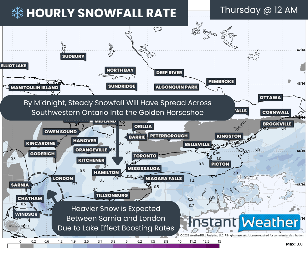
Hourly snowfall rates (cm) - MAP FROM WEATHERBELL
Snow has already begun across Deep Southwestern Ontario and will continue spreading northeastward through the evening. By around midnight, snowfall should be widespread across much of Southwestern Ontario and expanding into the Golden Horseshoe, including the Niagara region and western GTA.
For many locations, snowfall will begin as steady and moderate, gradually increasing in intensity through the overnight hours. Snowfall rates will generally sit around 1 to 2 centimetres per hour initially, which on its own may not seem overly concerning. The issue is the duration of the event, as these rates will persist for 12 hours or more in some areas, allowing snow to pile up over time.
The heaviest snowfall overnight is expected to be focused between Sarnia and London, where lake enhancement off Lake Huron may briefly boost snowfall rates higher. These heavier bursts could make travel especially difficult overnight and into the early morning hours.
Wind will also become a factor as the storm progresses. Gusts will increase to between 40 and 60 kilometres per hour in some areas overnight. When combined with falling snow, this will lead to blowing snow and reduced visibility, particularly in open and rural areas.
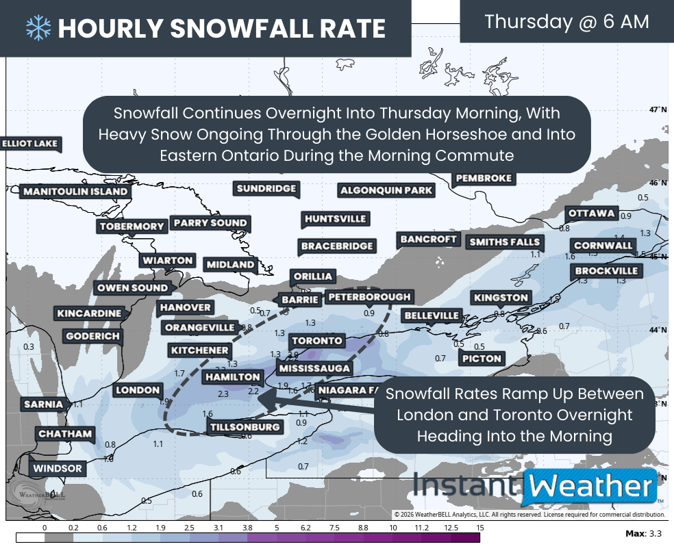
Hourly snowfall rates (cm) - MAP FROM WEATHERBELL
Conditions are expected to continue deteriorating into Thursday morning as snowfall intensity increases across much of the Golden Horseshoe. Areas from London through Hamilton and into the Greater Toronto Area could see periods of heavier snow during the morning hours. In the most intense bands, snowfall rates may briefly reach 2 to 4 centimetres per hour, which will make it very difficult for road crews to keep up.
Unfortunately, this lines up almost perfectly with the Thursday morning rush hour. Travel across the GTA and surrounding regions will be extremely slow, and in some cases nearly impossible, especially on secondary roads. If you can delay travel or work from home, Thursday morning would be an ideal time to do so.
Snow will also spread into Eastern Ontario overnight and early Thursday morning. The Ottawa area is expected to see snow arrive around or just before the morning commute, with conditions worsening through the late morning and early afternoon hours.
One of the most important details we are still watching closely is the northern cutoff of the heaviest snow. As shown on the forecast map, there is a sharp transition zone near areas such as Barrie and Peterborough. The American HRRR model suggests that locations just north of this line may see very little snow, while those south of it could see totals exceeding 20 centimetres.
Other model solutions shift this cutoff further south, which would place parts of the GTA closer to the lower snowfall edge. Meanwhile, some guidance shifts it further north, allowing areas like Barrie and Peterborough to see much higher totals. This uncertainty is why confidence drops significantly near this transition zone.
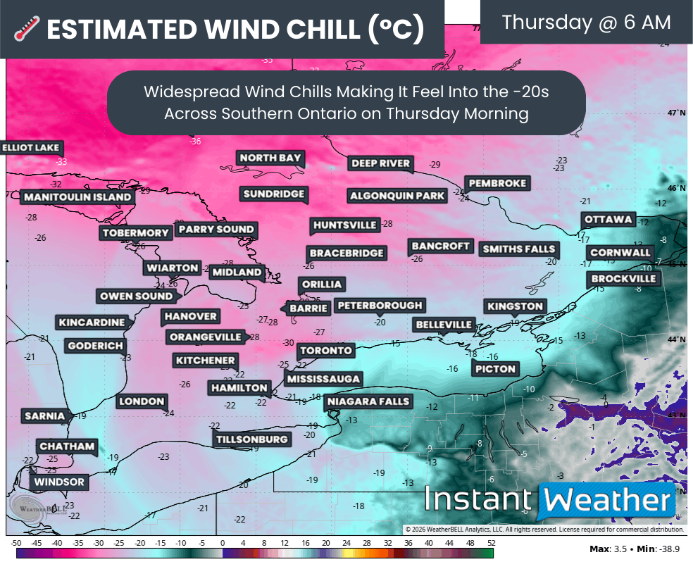
WIND CHILL - MAP FROM WEATHERBELL
Another key factor enhancing snowfall totals is the colder air moving in behind the system. By Thursday morning, many parts of Southern Ontario will feel like -20°C or colder once you factor in the wind chill.
As temperatures drop, the snow becomes lighter and fluffier. Colder air allows snowflakes to be less dense, which means the same amount of moisture can produce more snow on the ground. This is known as a higher snow-to-liquid ratio, and it is one reason totals may end up higher than initially expected.
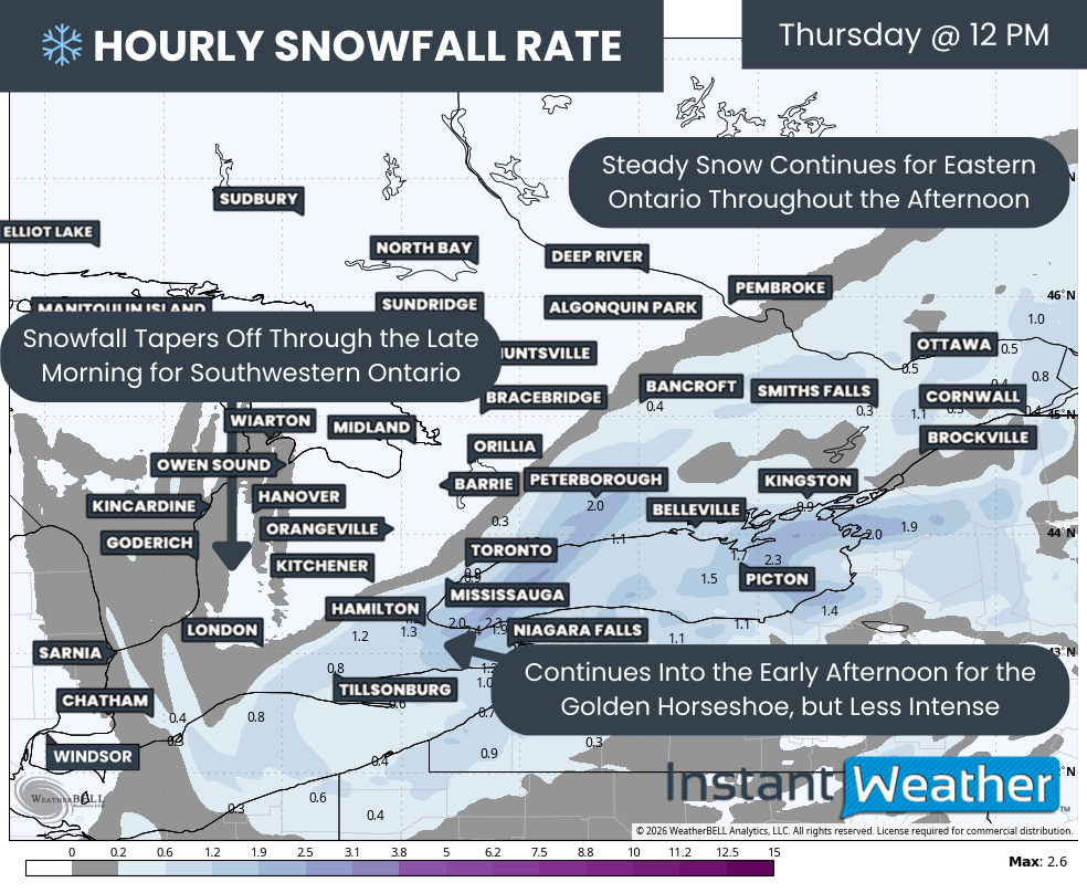
Hourly snowfall rates (cm) - MAP FROM WEATHERBELL
Through the late morning hours on Thursday, heavy snow is expected to continue across the Golden Horseshoe while spreading further east into Eastern Ontario.
In the west, areas near Lake Huron and Deep Southwestern Ontario should begin to see snowfall gradually taper off toward the end of the morning.
By around noon, steady snow should still be falling from the Golden Horseshoe eastward into Eastern Ontario. The Niagara region and eastern portions of the GTA may remain under heavier snowfall for the first part of the afternoon before intensity slowly begins to decrease.
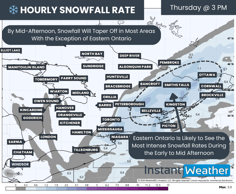
Hourly snowfall rates (cm) - MAP FROM WEATHERBELL
Eastern Ontario may end up seeing the worst conditions during the early to mid-afternoon hours. Snowfall rates here are expected to range between 1 and 3 centimetres per hour and could linger for several hours before tapering off later in the day.
Snow should finally begin to move out of most areas by late afternoon or early evening, though a few lingering flurries may persist into the evening across Eastern Ontario.
NOTE: YOU CAN CLICK ON THE MAP TO OPEN A ZOOMABLE IMAGE

The most challenging aspect of this storm remains the tight snowfall gradient. Small shifts in storm track will make a big difference in totals, and models continue to disagree on exactly where that cutoff will set up. This means forecast amounts could change with little notice.
After reviewing all available guidance, we have put together a snowfall forecast that reflects the most likely scenario based on the majority of model data. However, this is one of those events where nearly every model offers a slightly different outcome, and it would not take much for totals to shift in either direction.
The highest snowfall totals appear most likely in a corridor stretching from Sarnia through London, across the entire Golden Horseshoe, and into Eastern Ontario, including the Ottawa Valley. These areas can expect widespread totals of 20 to 40 centimetres, with isolated pockets possibly approaching or exceeding 50 centimetres.
This includes communities such as Sarnia, Chatham, London, Woodstock, Tillsonburg, Brantford, Niagara Falls, Hamilton, Kitchener, Guelph, Mississauga, Toronto, Oshawa, Belleville, Tweed, Kingston, Smiths Falls, Renfrew, Ottawa, Brockville and Cornwall.
Slightly lower totals in the 10 to 20 centimetre range are expected for areas like Windsor, Leamington, Grand Bend, Goderich, Hanover, Orangeville, Newmarket, Peterborough and Bancroft. This is also the zone with the lowest confidence, as some of these locations could end up with significantly more or less snow depending on where the cutoff ultimately sets up.
Further north and west, snowfall amounts drop off quickly. Areas such as Owen Sound, Barrie and Pembroke are expected to see less than 10 centimetres of accumulation, with little to no snowfall expected north of Orillia.
These totals remain subject to change, and adjustments are likely as the storm unfolds. We will be closely monitoring conditions throughout Thursday and will provide real-time updates as we see how the storm is evolving on radar and through observations.


