Damaging Ice Storm Risk for Ottawa, Eastern and Central Ontario Tuesday Night Into Wednesday
/
NOTE: YOU CAN CLICK ON THE MAP TO OPEN A ZOOMABLE IMAGE
Over the past few days, Southern Ontario has been treated to an early taste of spring-like weather. Temperatures soared well into the double digits across many areas, and some locations even managed to hit the 20°C mark for the first time this season.
After experiencing such a dramatic warm-up, it’s hard to imagine how quickly we could be plunging right back into the grip of winter. But it’s important to remember that we are only in early March. This time of year is well known for dramatic swings in the weather, and that reality will become very apparent across Central and Eastern Ontario over the next couple of days.
A moisture-packed system is set to slide through Southern Ontario beginning late Tuesday and continuing through Wednesday. This system will bring a wide variety of weather conditions depending on where you are located, ranging from heavy rain and thunderstorms in the south to a prolonged freezing rain threat further north and east.
Those in Southwestern Ontario and the Golden Horseshoe will continue to enjoy the milder temperatures in the double digits on Tuesday and Wednesday. With temperatures remaining well above freezing in these areas, the main focus will be on periods of heavy rain along with the potential for some thunderstorm activity.
With snowmelt already well underway or even complete following the recent warmth, this additional rainfall could further exacerbate ongoing flooding concerns in some areas. Localized flooding in low-lying areas and near rivers and creeks will remain something to watch closely through midweek.
Further north, this system is likely to encounter some colder air that will become entrenched across Central and Eastern Ontario. This will create a very sharp temperature divide across the province, with areas to the south seeing spring-like conditions while areas further north sit much closer to the freezing mark or even slightly below.
These below-freezing surface temperatures combined with warm air aloft will provide the perfect setup for freezing rain. Multiple waves of precipitation are expected to move through the region, creating the potential for a prolonged freezing rain event.
This pocket of cold air appears like it may become quite entrenched, particularly across Eastern Ontario and the Ottawa Valley. As a result, some areas could be dealing with freezing rain for 12-24 hours or even longer if the cold air proves stubborn enough to hold on.
If this scenario plays out, it could lead to ice accretion totals of at least 10mm with localized pockets potentially exceeding 25mm. Amounts like this would be more than enough to result in crippling impacts across parts of Eastern Ontario, including tree damage, widespread power outages and extremely hazardous driving conditions.
The worst icing currently appears likely to arrive in two waves. The first wave is expected to impact Central and Eastern Ontario overnight Tuesday and into Wednesday morning.
Later in the day on Wednesday, a second round of precipitation will move through during the late afternoon and evening hours. By this point, areas across Central Ontario and the southern portions of Eastern Ontario may have risen above the freezing mark, which would limit their impacts mostly to the morning hours.
There remains some uncertainty regarding whether the warmer air will be able to overcome the cold air at the surface during the afternoon on Wednesday. If temperatures manage to climb even slightly above freezing for a few hours in the Ottawa Valley, it could make a huge difference.
Even a brief period of above-freezing temperatures would allow some of the ice from the first wave to begin melting before the second round arrives. That could significantly reduce the risk of this becoming a truly destructive ice storm.
This detail will be particularly important because temperatures are expected to plunge again later Wednesday and could remain below freezing for at least the next few days. If no melting occurs beforehand, all of that accumulated ice would remain locked in place and could lead to prolonged impacts on trees and the power grid.
PRECIP TYPE - MAP FROM WEATHERBELL
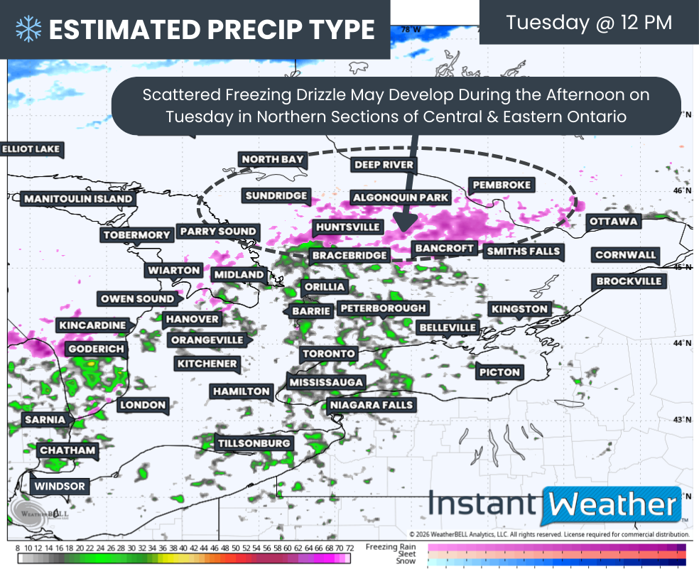
Before the main system arrives, some scattered showers and drizzle may begin developing on Tuesday afternoon across parts of Southern Ontario. Most areas should remain above freezing, but a small pocket along the northern edge of Central Ontario, including Huntsville, Algonquin Park and Pembroke, could be sitting very close to the freezing mark.
If that happens, some of the drizzle could freeze on contact with surfaces during the afternoon and evening hours ahead of the main system. While any ice accumulation should remain fairly minimal, it could still create some slick road conditions and add a thin layer of ice before the heavier precipitation arrives overnight.
PRECIP TYPE - MAP FROM WEATHERBELL
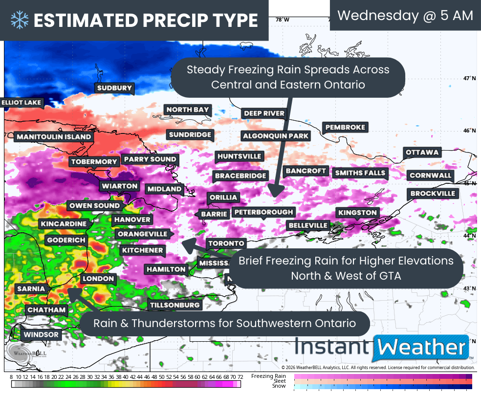
The first wave of heavier precipitation is expected to slide into Southern Ontario from the west just after midnight Tuesday night. It will then continue spreading eastward through the overnight hours and into early Wednesday morning.
For Southwestern Ontario, it could end up being a rather noisy night. Some nocturnal thunderstorms may move through, especially closer to the Lake Huron and Lake Erie shorelines.
Despite the thunderstorms, temperatures in this region will remain well above freezing, so there are no concerns for freezing rain here.
Further north and east, however, colder air closer to the freezing mark will likely be found along the higher elevations near the Golden Horseshoe, including the Dundalk Highlands. This colder air will extend into Central and Eastern Ontario from around Lake Simcoe through Peterborough and into Kingston.
Models are still disagreeing on just how extensive this below-freezing pocket will be. Some guidance keeps it fairly localized to the Dundalk Highlands, including areas like Orangeville and Shelburne.
Other models suggest a few hours of freezing rain could extend across a much larger area, including parts of the northern GTA, Simcoe County, Peterborough and Kingston.
Regardless of how far south the freezing rain extends, it is expected to be fairly short-lived in these areas as temperatures should rise above freezing by the late morning hours on Wednesday, switching precipitation over to plain rain.
The primary problem area continues to look like a corridor stretching from the Bruce Peninsula through Muskoka, Haliburton, Bancroft and into the Ottawa Valley.
Current indications suggest the cold air will hold on much longer in this region, and in the case of the Ottawa Valley, temperatures may struggle to rise above freezing at all throughout the day on Wednesday.
PRECIP TYPE - MAP FROM WEATHERBELL
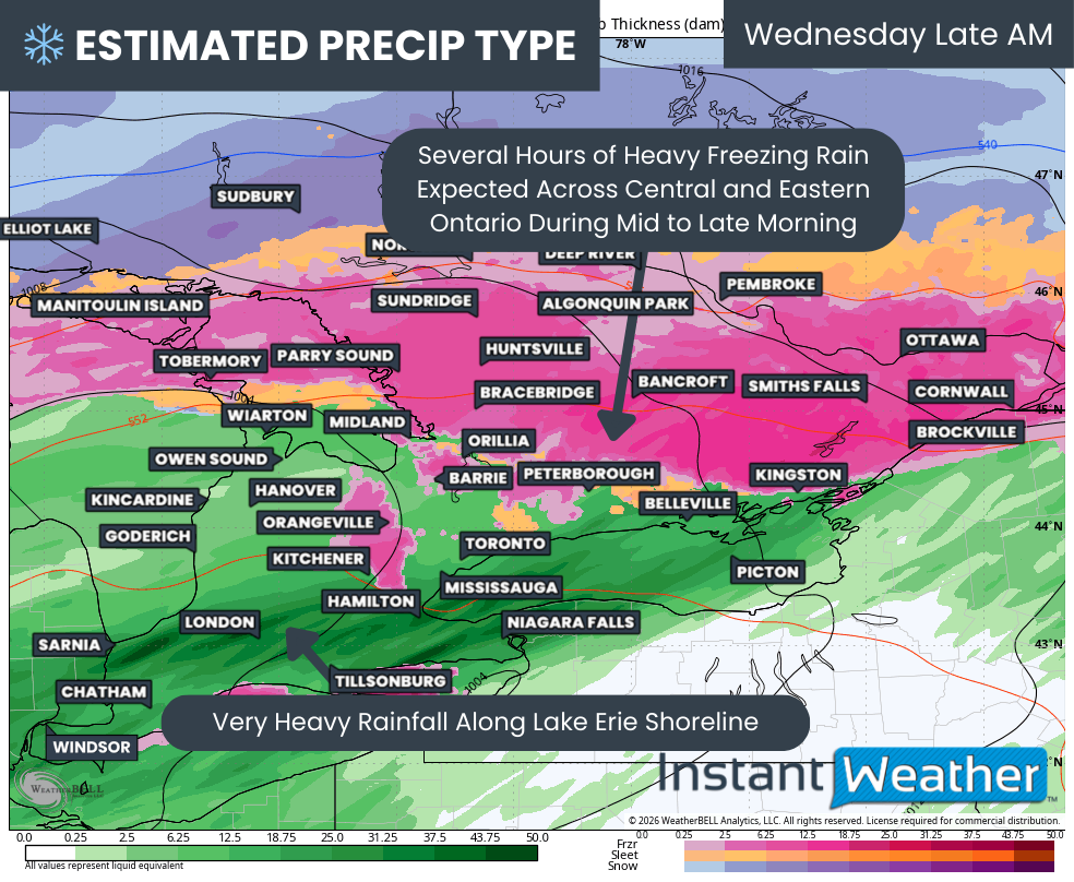
As a heavy pocket of freezing rain moves through, starting across Central Ontario during the mid-morning hours and reaching the Ottawa Valley by late morning, substantial ice accretion could begin to build quickly.
Precipitation rates may become quite heavy at times, which adds another layer of uncertainty when it comes to ice accumulation. During intense bursts of freezing rain, some of the liquid can drip off surfaces before it has time to freeze.
Even so, conditions are expected to become treacherous through the morning and into the early afternoon across parts of Central and Eastern Ontario. Ice will rapidly build up on tree branches, power lines and other exposed surfaces.
ESTIMATED TEMP - MAP FROM WEATHERBELL
One of the biggest challenges with forecasting freezing rain events is that the setup requires a very specific temperature profile. If models are off by even a single degree, it can dramatically change the outcome.
Just a small temperature difference can mean the difference between a crippling ice storm and a much less impactful rainfall event.
This system is no exception. There are some subtle but important differences between the model solutions that could significantly alter the final outcome.
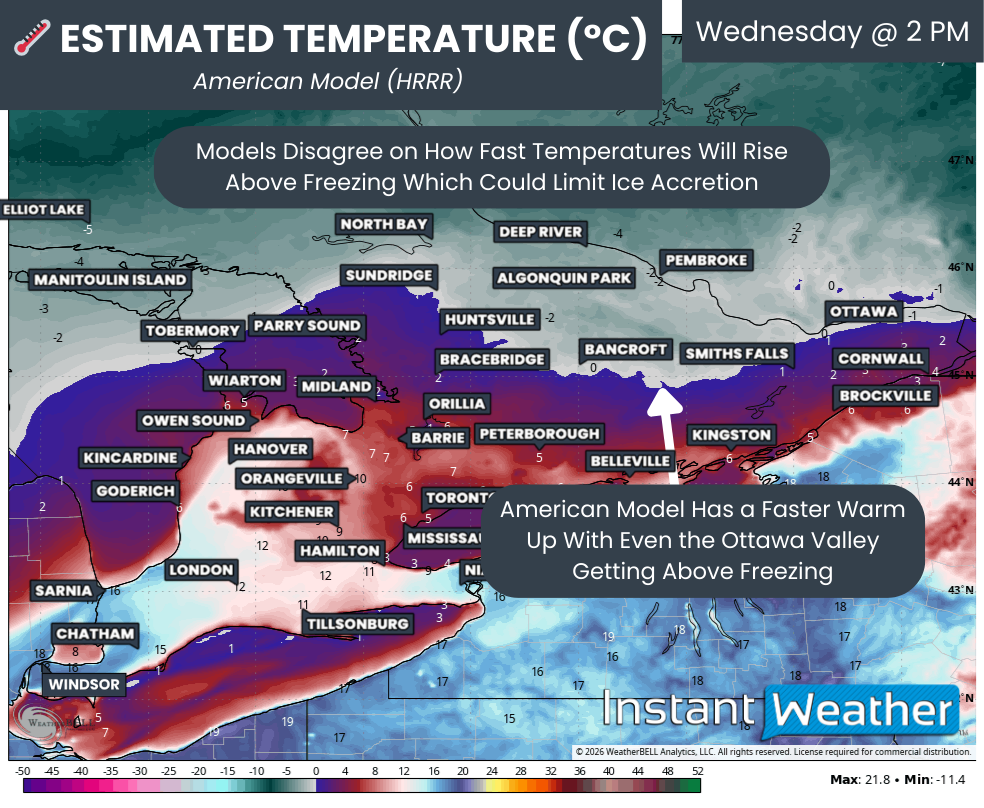
Most models show above freezing temperatures gradually pushing northward into Central and Eastern Ontario beginning late Wednesday morning and into the early afternoon. The key question is how far north the warmer air will be able to penetrate.
The American model is the most aggressive with the warm air, pushing the freezing line as far north as Bancroft and even Ottawa. If that scenario occurs, locations including Muskoka, Haliburton, Smiths Falls, Brockville, Cornwall and parts of Ottawa could briefly rise above freezing and bring an end to the freezing rain threat by early afternoon.
ESTIMATED TEMP - MAP FROM WEATHERBELL
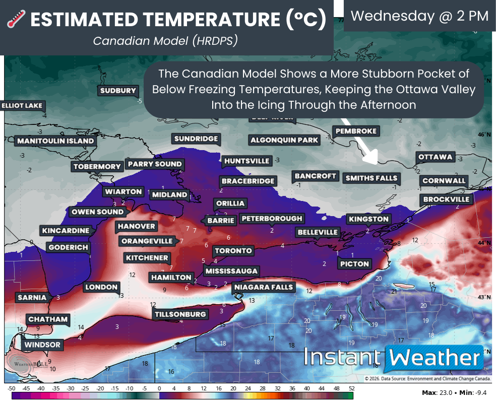
The Canadian model, on the other hand, keeps the cold air much more entrenched across the Ottawa Valley. In that scenario, temperatures remain below freezing through the afternoon, which would allow freezing rain to continue and prevent any earlier ice accumulation from melting away.
Even if some areas do briefly rise above freezing during the afternoon, that warm-up will likely be short-lived.
Colder air is expected to wrap back into the system as a second round of precipitation moves through Central and Eastern Ontario during the late afternoon and early evening hours.
PRECIP TYPE - MAP FROM WEATHERBELL
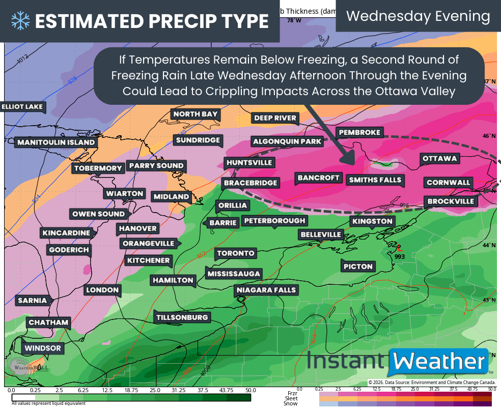
Current indications suggest the mixing line may set up somewhere around Muskoka, extending eastward through Bancroft and into the Brockville area.
This would allow another swath of heavy freezing rain to develop across the Ottawa Valley, which could add even more ice accumulation and further amplify impacts during the evening hours. This should taper off around midnight, switching to light snow overnight into Thursday morning.
For Southwestern Ontario, there is also the possibility of some freezing rain or snow mixing in toward the later part of Wednesday as colder air wraps in behind the departing system. At this point, however, any wintry precipitation in the southwest is not expected to be significant.
NOTE: YOU CAN CLICK ON THE MAP TO OPEN A ZOOMABLE IMAGE

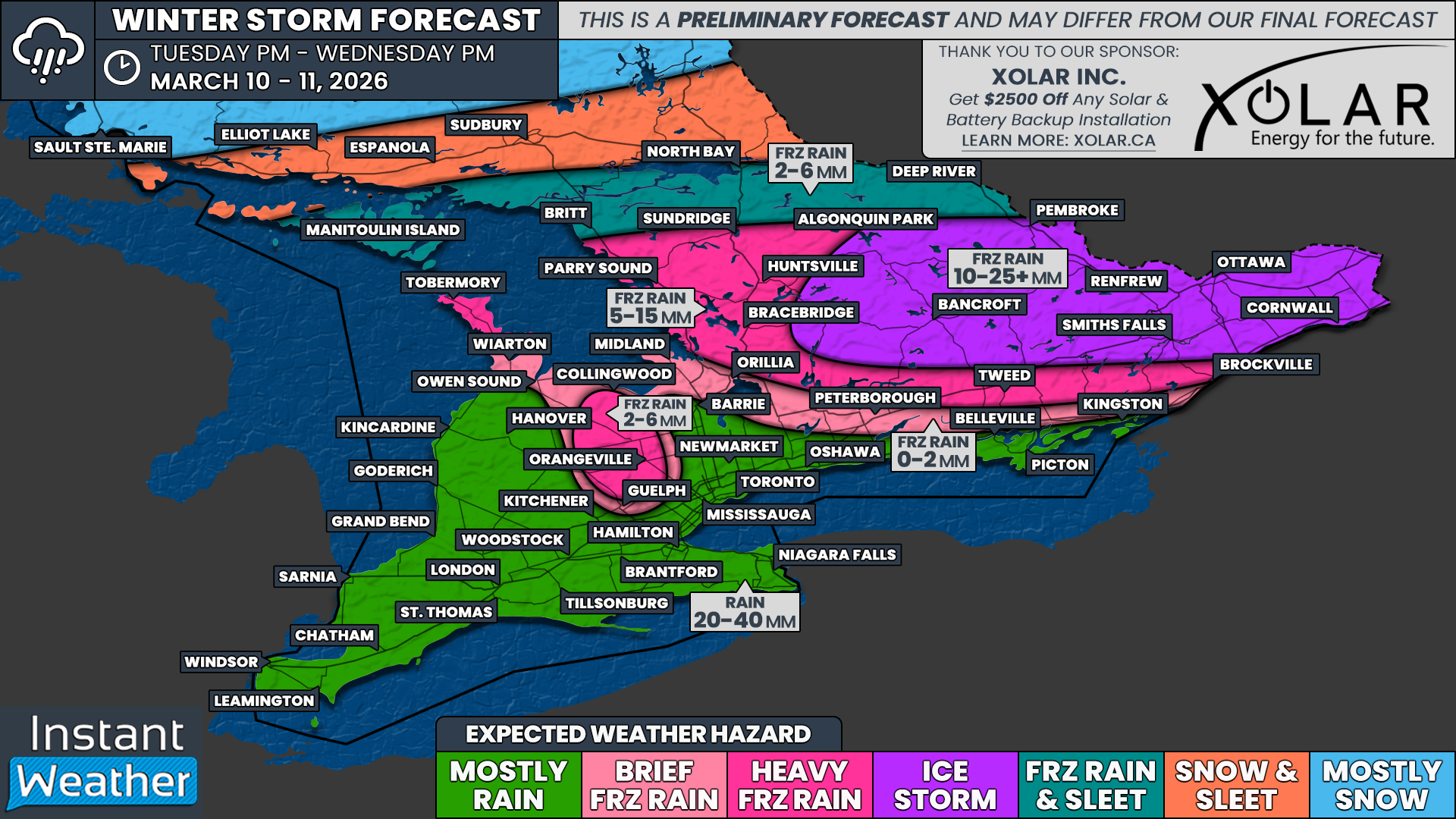
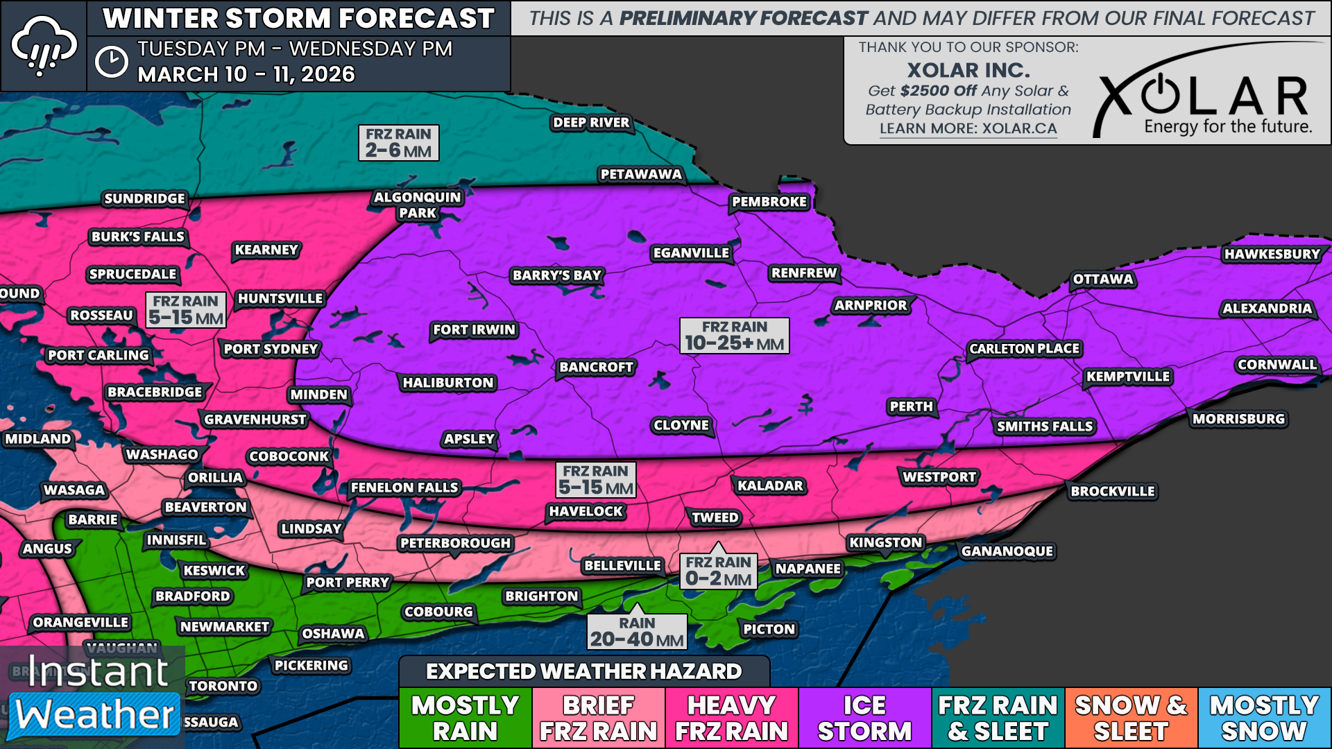
When it comes to the hardest hit areas, we are currently looking at ice storm level impacts potentially developing across much of Eastern Ontario. This includes communities such as Ottawa, Hawkesbury, Alexandria, Cornwall, Kemptville, Carleton Place, Smiths Falls, Perth, Arnprior, Renfrew, Bancroft, Pembroke, Barry’s Bay, Haliburton and Minden.
General ice accretion across this region could range from 10 to 25mm with localized pockets, especially east of Ottawa, closer to the Quebec border, potentially exceeding 25mm.
As mentioned earlier, locations along the southern edge of this zone, including Perth, Smiths Falls, Kemptville and Cornwall, could see somewhat lower ice totals if temperatures briefly rise above freezing during the late morning and afternoon hours.
Outside of the ice storm zone, prolonged freezing rain is still expected across much of Central and Eastern Ontario, roughly north of a line from Orillia to Brockville.
This includes areas such as Brockville, Westport, Kaladar, Havelock, Fenelon Falls, Gravenhurst, Bracebridge, Huntsville, Parry Sound, Burk’s Falls and Sundridge.
Ice accretion in these areas will likely range from 5 to 15mm, with most of the accumulation occurring during the morning hours on Wednesday before temperatures rise above freezing later in the day.
Exactly how quickly this switchover to rain occurs will determine the final ice totals. A faster transition to rain would likely keep totals closer to 5mm, while a slower warm-up could allow some areas to approach 15mm.
Some brief freezing rain during the pre-dawn hours on Wednesday is also possible for locations including Midland, Orillia, Lindsay and Kingston. However, it should remain very minor as temperatures are expected to rise above freezing fairly quickly, switching precipitation over to rain after an hour or two.
The higher elevations of the Dundalk Highlands may be able to hold onto below-freezing temperatures for a few additional hours. Areas such as Orangeville and Shelburne could see around 2 to 6mm of freezing rain accumulation, mostly during the morning hours.
Once temperatures climb above freezing, though, impacts in these areas should quickly improve.
In locations that remain mostly rain, we are generally expecting between 20 and 40mm of rainfall across Southwestern Ontario and into the Golden Horseshoe.
Localized heavier pockets of 50 to 75mm are possible closer to the Lake Erie shoreline, especially in areas that see thunderstorm activity develop within the system.
Keep in mind that this remains a preliminary forecast, and details may still shift before the system arrives. We will have a much more refined forecast on Tuesday with updated timing and precipitation totals as we get closer to the event.


