Canada Day Heatwave Set to Grip Southern Ontario With Near 40°C Heat and Severe Storm Risk
/THIS FORECAST IS SPONSORED BY:
NOTE: YOU CAN CLICK ON THE MAP TO OPEN A ZOOMABLE IMAGE
As we approach the end of June, the weather is set to heat up in a big way across Southern Ontario with the arrival of a prolonged heatwave that is expected to bring dangerously hot temperatures by Canada Day. Based on the latest forecast data, there appears to be very little relief from the heat in the short term, with above seasonal temperatures potentially lasting through much of the week before easing closer to normal by next weekend.
The heat begins to build on Monday and Tuesday with daytime highs approaching the 30°C mark for the first time during this event. Ironically, these may end up being the “coolest” days of the week as temperatures continue to climb, with some areas potentially reaching the mid 30s by Canada Day, even before humidity is taken into account.
To make matters worse, there will be very little relief overnight. Starting Tuesday night, temperatures are expected to remain in the low to mid 20s across much of Southern Ontario. These unusually warm nights prevent homes and buildings from cooling down and give people little opportunity to recover from the daytime heat, increasing the risk of heat-related illnesses, especially after several consecutive days of extreme temperatures.
In addition to the heat, this warming trend is also expected to create an increasingly unstable atmosphere that will provide plenty of fuel for thunderstorms throughout the week. That doesn't necessarily mean storms will develop every day. Thunderstorms also require a trigger to get started, even when the atmosphere is primed.
However, the ingredients are expected to be in place for multiple rounds of thunderstorms over the coming week, including the potential for severe weather beginning as early as Tuesday.
ESTIMATED TEMPERATURE (°C) - MAP FROM WEATHERBELL
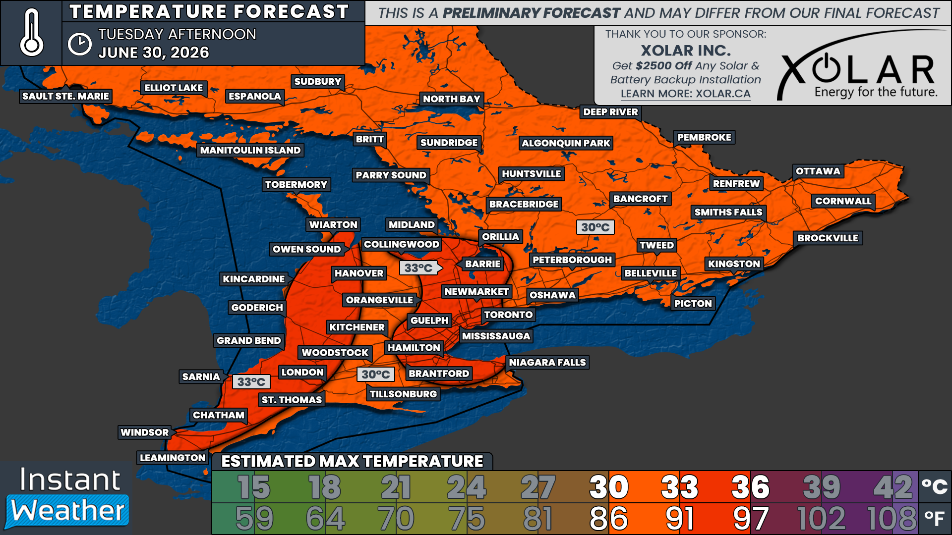
This heat event officially begins on Monday with daytime temperatures generally ranging from 27 to 30°C across Southern Ontario.
Keep in mind that communities located along the shorelines of the Great Lakes may remain a few degrees cooler where lake breezes develop. These breezes act like a natural air conditioner by pulling cooler air off the water and pushing it inland, offering some temporary relief for locations directly downwind.
NOTE: YOU CAN CLICK ON THE MAP TO OPEN A ZOOMABLE IMAGE
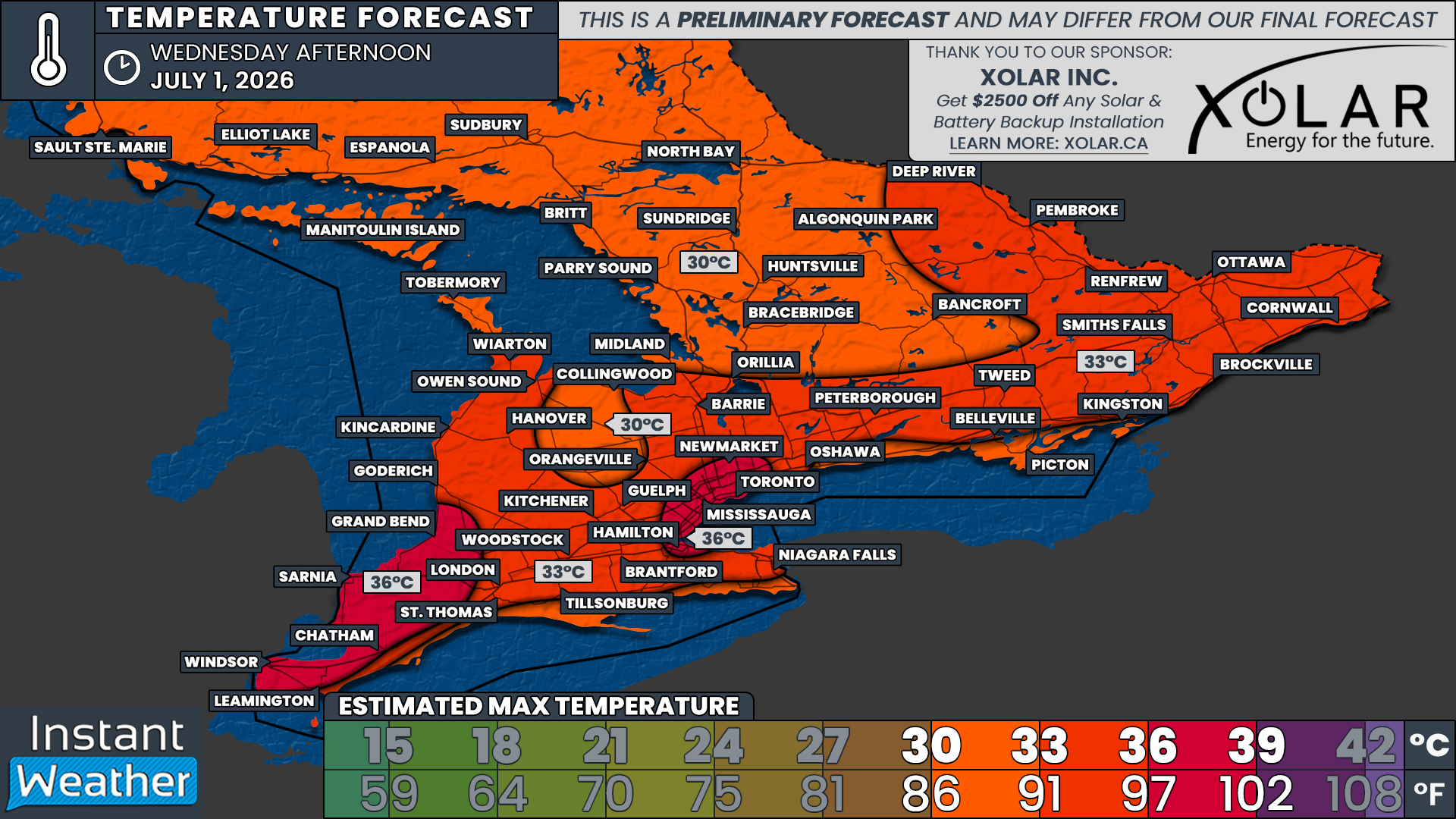
Tuesday brings another step upward with daytime highs expected to exceed 30°C across nearly all of Southern Ontario.
The hottest temperatures are expected across Southwestern Ontario, along with the Golden Horseshoe, where the urban environment creates what is known as the ‘urban heat island’ effect. Cities contain large amounts of concrete, asphalt and buildings that absorb heat from the sun throughout the day. Unlike forests or grassy areas, these surfaces release that stored heat slowly overnight, causing cities to remain noticeably warmer than surrounding rural areas, especially during prolonged heat events.
Temperatures in these areas are currently forecast to reach between 33 and 36°C. Once humidity is factored in, it could feel more like the upper 30s or even low 40s.
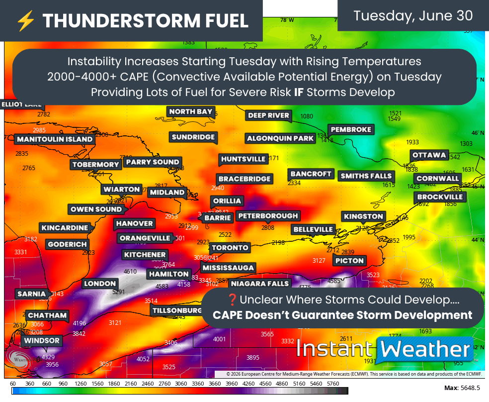
ESTIMATED CAPE - MAP FROM WEATHERBELL
Along with the increasing temperatures on Tuesday will come a significant surge in thunderstorm energy. Forecast models are showing CAPE (Convective Available Potential Energy) values ranging from 2,000 to more than 4,000 J/kg across much of Southern Ontario. For perspective, CAPE values between 1,000 and 2,000 J/kg are already considered more than sufficient to support strong to severe thunderstorms.
While CAPE is only one ingredient needed for severe weather, it gives us an indication of how much energy is available for developing thunderstorms. The higher the CAPE, the greater the potential for storms to grow rapidly and become intense if they are able to form.
What CAPE cannot do on its own is actually produce thunderstorms. A triggering mechanism is still needed to force warm, humid air upward. Common triggers include an approaching cold front, a warm front, lake breeze boundaries, outflow boundaries from earlier storms or even the heating of the ground during the afternoon. Without one of these lifting mechanisms, the atmosphere can remain loaded with energy while little or no storm development occurs.
Since this energy is expected to remain in place for much of the week, there is a high likelihood that at least a few rounds of thunderstorms will develop. Some of these storms could certainly become severe. At this point, Wednesday and Thursday appear to offer the greatest chance for thunderstorm development, although we're still several days away and the exact timing, location and severity will become clearer as we get closer. This will need to be closely watched as it could put a damper on Canada Day celebrations.
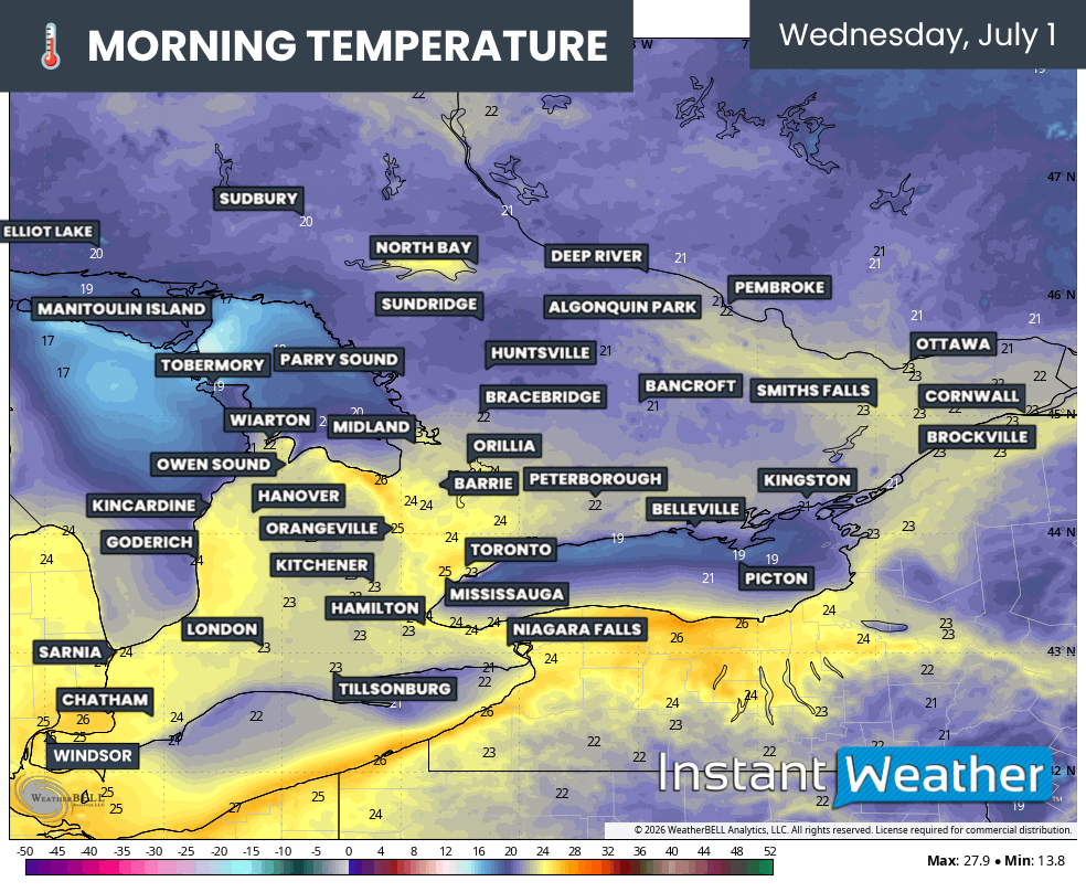
ESTIMATED TEMPERATURE (°C) - MAP FROM WEATHERBELL
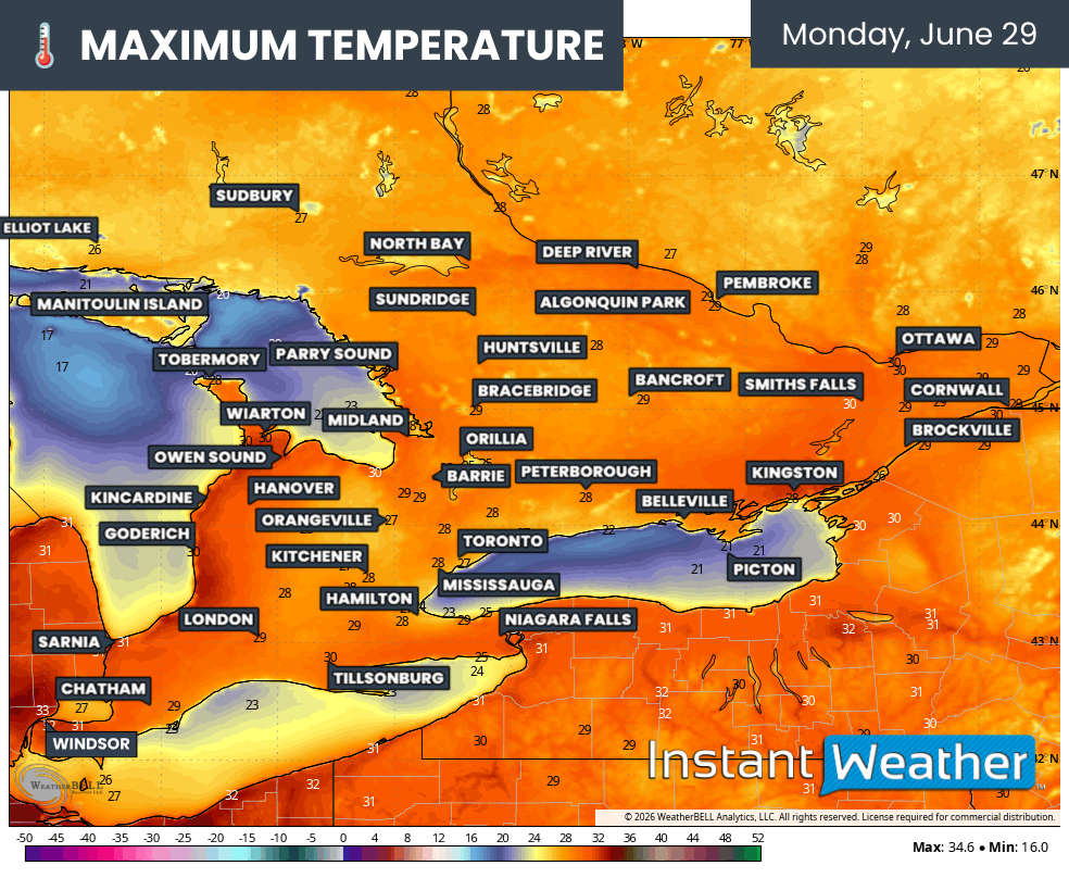
While temperatures will cool somewhat overnight, the overnight relief will be minimal, particularly across Southwestern Ontario and the Greater Toronto Area.
Current projections suggest temperatures on Wednesday morning may struggle to fall below 25°C in these areas before sunrise, with most other parts of Southern Ontario remaining above 20°C.
These warm overnight temperatures are particularly concerning because they greatly increase the health risks associated with prolonged heat. Normally, cooler nights allow the body to recover from daytime heat stress and help homes naturally cool down.
When temperatures stay elevated all night, that recovery becomes much more difficult, especially for seniors, young children, those with chronic health conditions and anyone without access to air conditioning, such as the unhoused. Several consecutive nights of poor overnight cooling can significantly increase the risk of heat exhaustion and heat stroke.

Extreme heat can affect anyone, not just vulnerable groups, so it's important to take precautions throughout this event.
Stay well hydrated by drinking plenty of water, even if you don't feel thirsty, and try to avoid alcohol or excessive caffeine, which can contribute to dehydration.
Limit strenuous outdoor activities during the hottest part of the day, typically from late morning through the early evening, and wear lightweight, loose-fitting, light-coloured clothing whenever possible.
If you have access to air conditioning, spend time indoors where it's cool. If not, consider visiting a shopping mall, library or community cooling centre for a few hours. Also remember to check in on family members, friends and neighbours, especially older adults, young children and those with underlying health conditions.
Never leave children or pets inside a parked vehicle, even for a few minutes. Temperatures inside a vehicle can climb to dangerous levels extremely quickly!
Finally, learn to recognize the warning signs of heat-related illness. Symptoms such as dizziness, nausea, headache, heavy sweating or confusion should never be ignored. Heat stroke is a medical emergency and requires immediate medical attention!

NOTE: YOU CAN CLICK ON THE MAP TO OPEN A ZOOMABLE IMAGE
THIS FORECAST IS SPONSORED BY:
As we head into Canada Day, it is shaping up to be an exceptionally hot day with temperatures potentially reaching between 36 and 38°C across Deep Southwestern Ontario and portions of the Greater Toronto Area.
Once again, temperatures could be noticeably cooler near the Great Lakes, where lake breezes develop. With southwesterly winds currently expected, the greatest cooling influence will likely be found along the northeastern shorelines of the lakes.
Elsewhere across Southern Ontario, temperatures are expected to range from 33 to 36°C across much of Southwestern Ontario, around Lake Simcoe and into Eastern Ontario. Central Ontario, along with the higher elevations of the Dundalk Highlands, should remain slightly cooler with highs between 30 and 33°C.
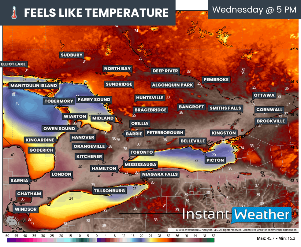
ESTIMATED FEELS LIKE (°C) - MAP FROM WEATHERBELL
Humidity is also expected to continue increasing through Wednesday and Thursday, making it feel even hotter. Factoring in the humidex, it could feel well into the low to mid-40s across much of Southern Ontario. The highest humidex values are expected across Deep Southwestern Ontario and the Golden Horseshoe, although Eastern Ontario could also see "feels like" temperatures approaching 40°C.
A similar setup is expected on Thursday with many areas once again climbing into the mid-30s. Temperatures may ease slightly on Friday before a more noticeable cooldown arrives next weekend, bringing conditions back closer to seasonal values.
While the exact timing of that relief may still shift over the coming days, confidence is increasing that Southern Ontario is about to experience its most significant and prolonged heat event of the year so far. Residents should be prepared for several consecutive days of dangerous heat and stay up to date with the latest forecasts as the week progresses.