


Widespread Severe Thunderstorm Threat in Southwestern Ontario Sunday With Timbit-Sized Hail and Damaging Winds Possible
/
NOTE: YOU CAN CLICK ON THE MAP TO OPEN A ZOOMABLE IMAGE
After a few days of below-seasonal temperatures across Southern Ontario, with daytime highs making it feel more like early September, temperatures are back on the upswing over the next few days.
The cooler weather also brought a quieter period for thunderstorm activity, with our last widespread severe weather event occurring on Tuesday.
While no extreme heat is expected in the near future, temperatures will climb slightly above seasonal levels to start the week. Many areas will see daytime highs in the upper 20s or even low 30s on Monday.
That will be enough to increase instability and bring the potential for multiple rounds of thunderstorms beginning Sunday.
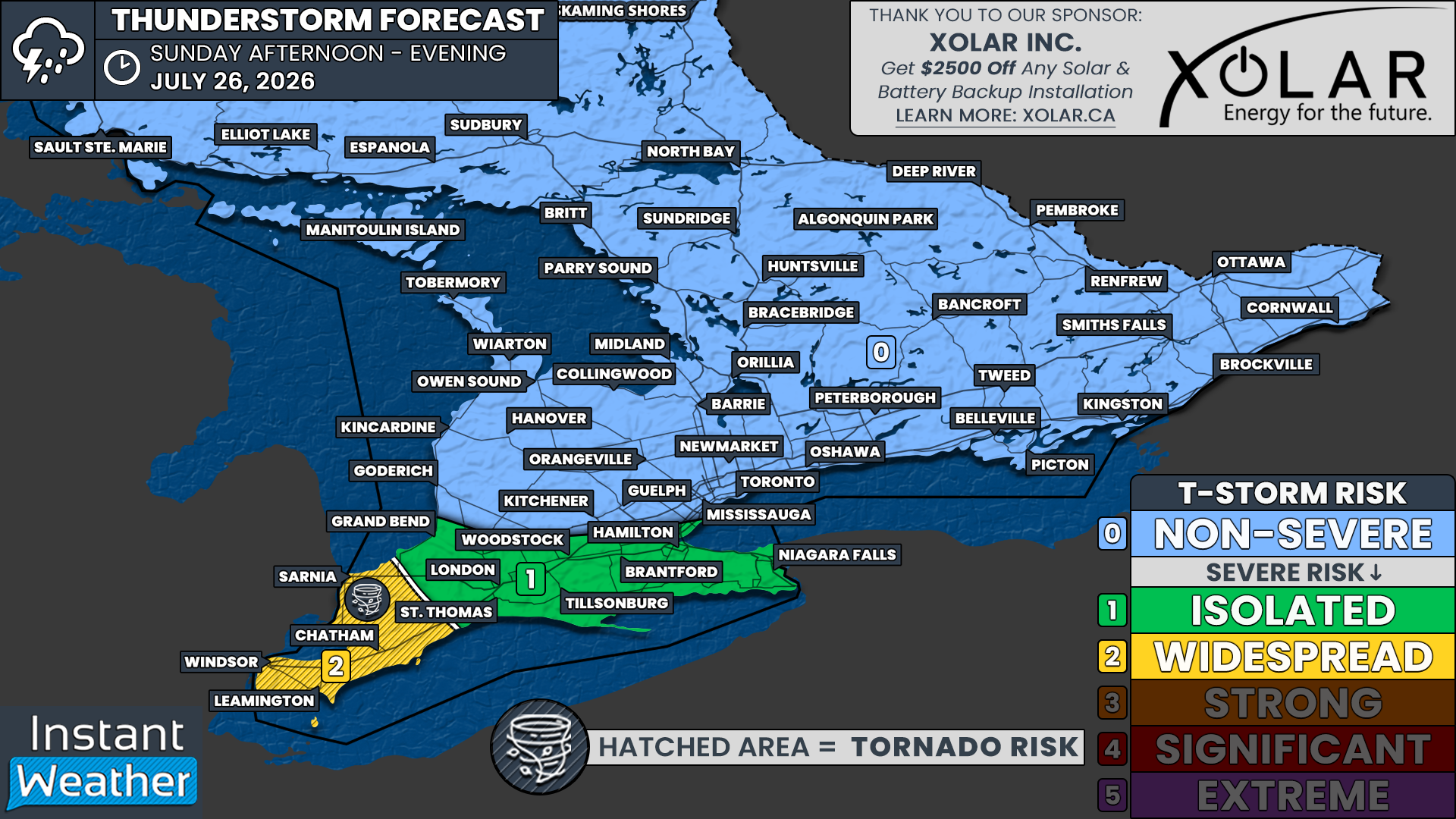
Sunday’s severe thunderstorm threat is expected to be mostly confined to Deep Southwestern Ontario, including Windsor, Chatham and Sarnia. Moderate instability combined with strengthening wind shear could create an environment capable of supporting severe storms.
However, there is still some uncertainty about whether storms will develop and exactly where they might form, as there is no obvious trigger such as a cold front.
Instead, storm development will depend on whether isolated cells can form along smaller-scale boundaries, including lake breezes.
Lake breeze-driven pop-up storms will be possible across Southern Ontario. However, outside of the Lake Erie shoreline and Deep Southwestern Ontario, the environment is not expected to be strong enough to support anything more than isolated, non-severe storms.
Join Us on YouTube for Storm Coverage:
We'll be providing comprehensive live coverage of any storms that develop Sunday on our YouTube channel. Our team will be tracking storms in real time with live radar analysis, warnings, and storm reports, so if severe weather threatens your area, be sure to join us live to help stay informed.
NOTE: YOU CAN CLICK ON THE MAP TO OPEN A ZOOMABLE IMAGE
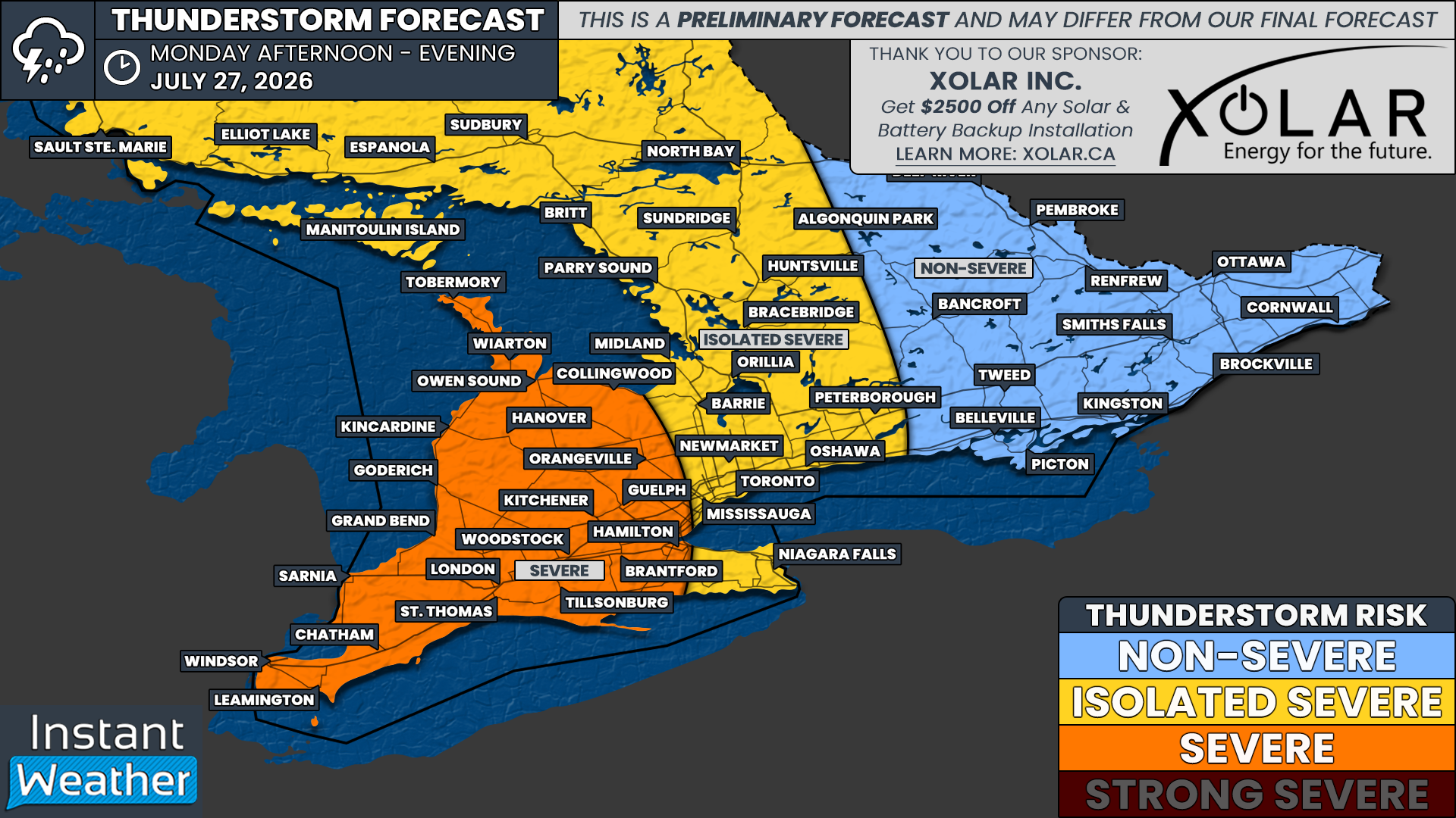
The focus is expected to remain on Southwestern Ontario on Monday, although more widespread thunderstorm development appears increasingly likely as a cold front potentially sweeps through later in the day.
The timing of that cold front is still uncertain and will have a significant effect on the severity of Monday’s storms. A later arrival during the prime hours of daytime heating would likely result in a stronger severe weather threat compared to an evening arrival.
At this point, a wide swath of Southwestern Ontario, including Windsor, Sarnia, London, Hamilton, Kitchener, Goderich, Hanover and Owen Sound, could see severe storms on Monday.
There is also an isolated severe risk extending into the Greater Toronto Area and portions of Central and Northeastern Ontario, including Barrie, Peterborough, Muskoka, Parry Sound, North Bay and Sudbury.
We’ll have more details about Monday’s storm risk, including the expected hazards and timing, in a separate forecast.

DATA FROM WEATHERBELL
For Sunday, isolated thunderstorm activity is possible across Southern Ontario beginning during the early afternoon and continuing into the evening.
Most of these storms are expected to remain below severe levels, with small hail, strong wind gusts and heavy rainfall as the main threats.
The greatest concern for severe weather will be across Deep Southwestern Ontario, extending along the northern Lake Erie shoreline and into the Hamilton and Niagara regions.
If lake breeze boundaries can trigger storms in this area, the environment could support a few storms reaching severe levels. Damaging wind gusts and large hail would be the primary threats.
Weather models often struggle to predict lake breeze-driven pop-up storms. However, the latest data has consistently focused on the Windsor to Leamington corridor as the area most likely to see a storm between 5 and 9 p.m.
Additional thunderstorm activity could develop farther north and east, including around Sarnia, Chatham, London and Hamilton, although models are less certain about storm development in these areas.
The severe weather risk should quickly diminish after sunset, around 9 p.m., as storms lose the daytime heating that helped fuel their development.
DATA FROM WEATHERBELL
Large hail and damaging wind gusts will be the primary threats from any severe storms that develop across Deep Southwestern Ontario on Sunday.
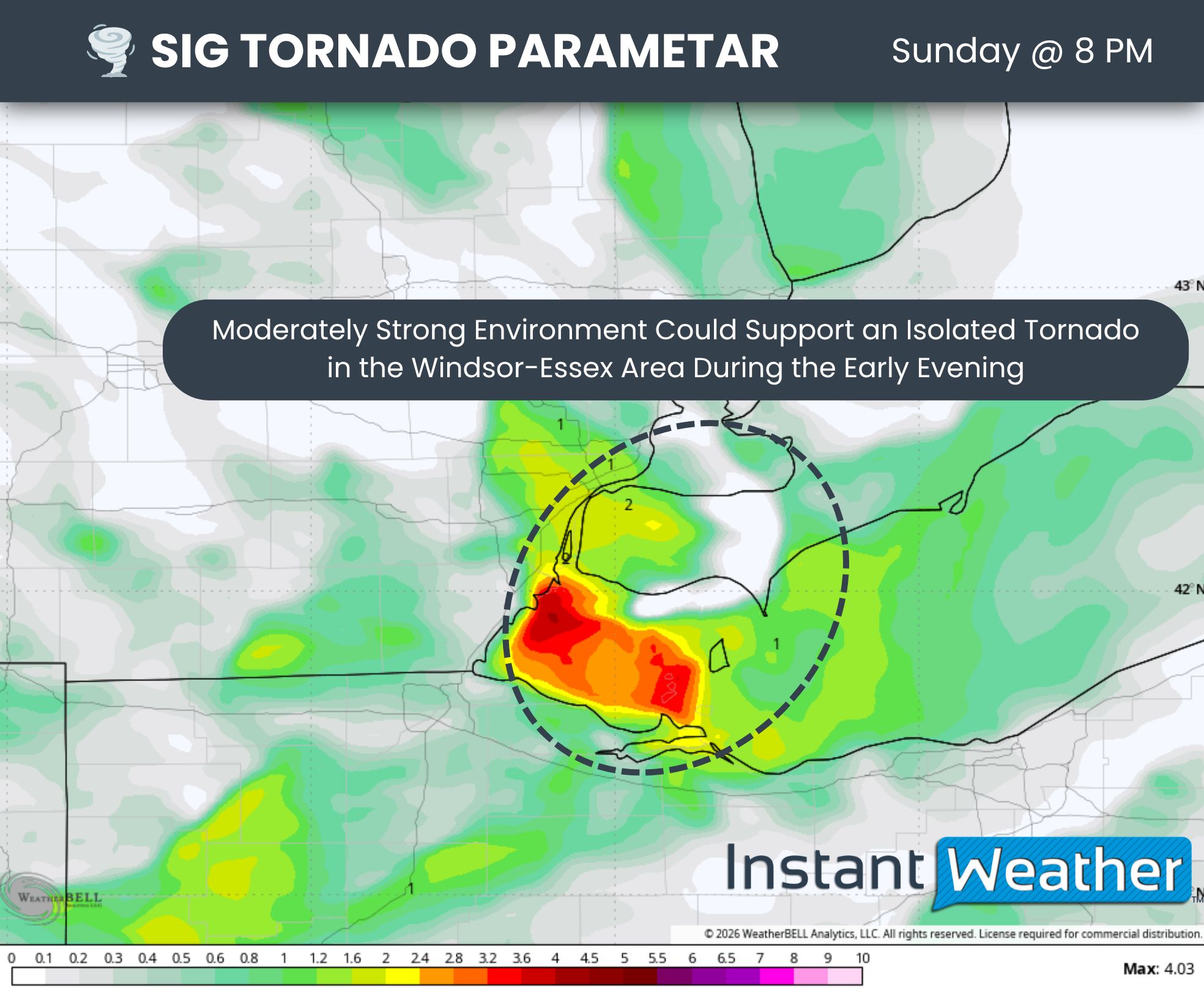
However, increasing wind shear during the early evening could create a narrow window capable of supporting a brief spin-up and an isolated tornado.
The latest model data shows an elevated Significant Tornado Parameter across Essex County. This parameter highlights areas where the atmospheric ingredients could support tornado development.
The most favourable environment appears to be concentrated over Essex County, although it may extend into Chatham-Kent and along the Lake Erie shoreline.
NOTE: YOU CAN CLICK ON THE GRAPHIC TO OPEN A ZOOMABLE IMAGE

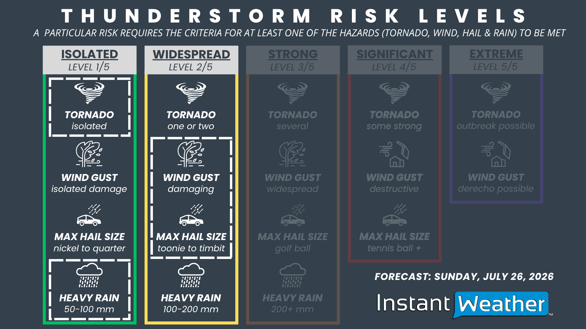
We have a ‘widespread’ severe risk for Windsor, Leamington, Chatham and Sarnia. This risk is driven by the potential for damaging wind gusts and hail up to the size of a Timbit. An isolated tornado cannot be ruled out.
There is an ‘isolated’ severe risk farther north and east along the Lake Erie shoreline, including Grand Bend, London, St. Thomas, Woodstock, Tillsonburg, Brantford, Hamilton and Niagara Falls.
A few storms in this area could reach marginally severe levels, producing hail up to the size of a quarter and isolated damaging wind gusts.
Across the rest of Southern Ontario, isolated non-severe thunderstorms are possible throughout the afternoon and early evening, including across the Golden Horseshoe and portions of Central and Eastern Ontario.
While these storms are expected to remain below severe levels, anyone planning to be outside or on the water should closely monitor the radar.
Be prepared to seek shelter indoors if a storm approaches, as even non-severe thunderstorms can pose a significant safety risk due to lightning, strong wind gusts and small hail.



