Yet Another Round of Intense Winds and Whiteouts Will Batter Alberta & Saskatchewan Tonight Ahead of Bitter Cold
/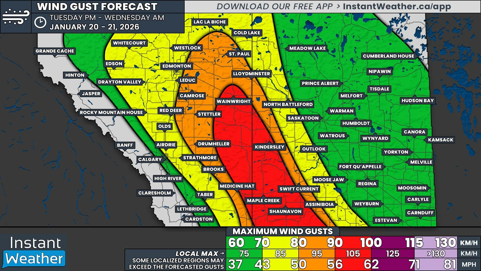
NOTE: if you click or tap on this image you can zoom in
In a seemingly never ending trend of strong winds, it comes as no surprise that we’re in for another bout of intense wind gusts beginning this evening and continuing into Wednesday morning. These strong northerly winds will be courtesy of a cold front that will blast southward from the Northwest Territories, having already crossed into Northern Alberta earlier this afternoon.
As the cold front makes its way across Northern Alberta through the remainder of the afternoon and into the early evening, 70-80km/h gusts are likely. The winds will become stronger as the cold front moves into Central Alberta a bit later in the evening, with gusts expected to exceed 80km/h over most of Eastern Alberta and into Southwest Saskatchewan. This also includes the possibility of gusts up to, and even exceeding, 100km/h, particularly from Kindersley and southeastward to the US border. The strongest winds will exit the region before sunrise, but gusts upwards of 60km/h are expected to linger into Wednesday evening.
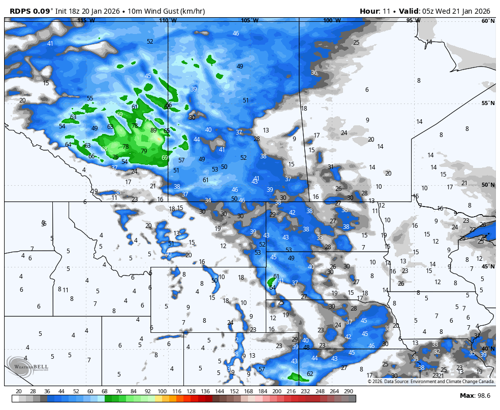
The rdps model showing wind gusts at 10pm MT/11pm CT on Tuesday. courtesy of WeatherBell.
These winds will also once again be accompanied by snow. Bands of flurries are expected to organize into snow squalls, which will reduce visibility in impacted areas. Given how narrow the bands are anticipated to be, there will likely be periods of rapid reductions in visibility followed by sudden clearing. It is also unlikely that there will be any blizzard warnings issued this time around because of how short-lived the whiteouts should be.
Overall, we could see a few centimetres of snow falling, but with the wind, it’ll be impossible to measure anyways. The exception to this will be in deep Southwestern Saskatchewan, in the Cypress Hills area, where 5-10cm of snow could accumulate.
The arrival of this cold front will be the precursor of frigid Arctic air that is slated to start to flood south later in the day Wednesday, and will persist until the beginning of next week. By Friday morning, we’re looking at widespread temperatures in the range of -25°C to -45°C across the Prairies, with windchills below -50°C!
We will have more details regarding how cold it will get and where in the coming days, but you’re definitely going to want to bundle up for the rest of the week!
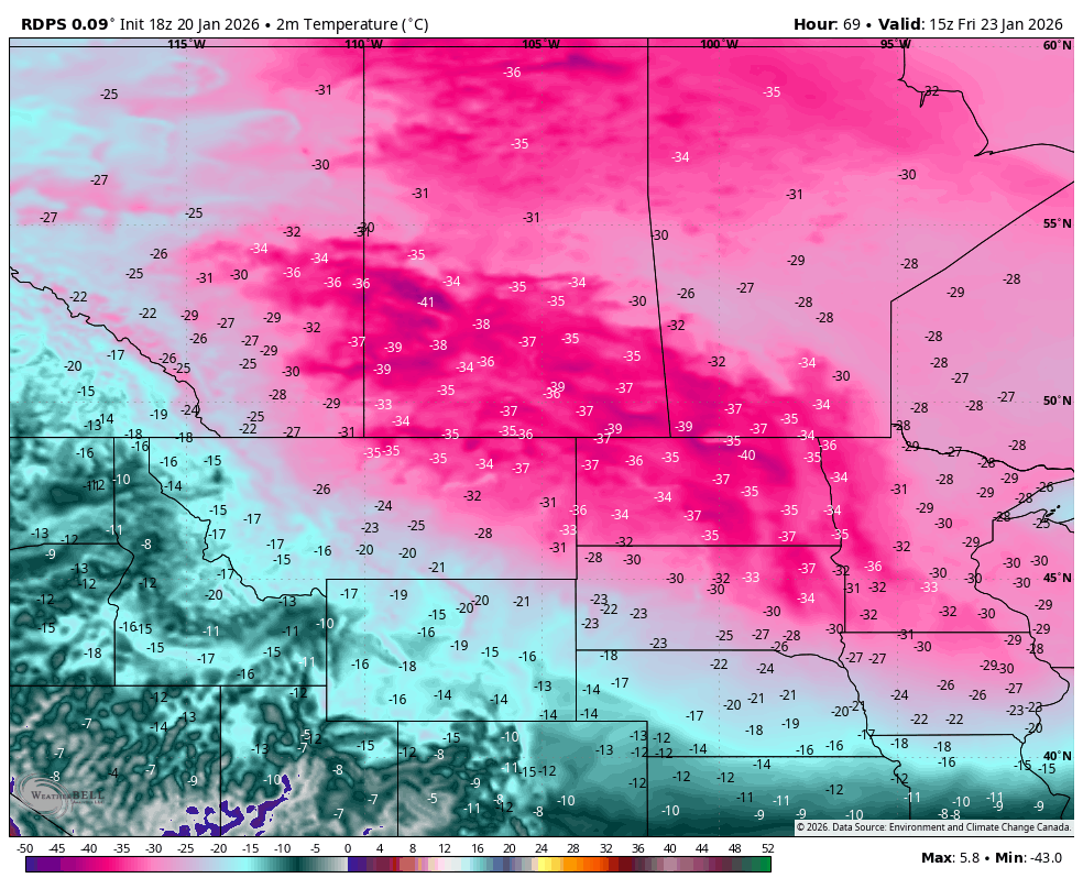
The rdps model showing air temperatures at 8am MT/9am CT on Friday. courtesy of WeatherBell.


