Widespread Tornado Threat and Softball-Sized Hail Possible with Extreme Thunderstorm Risk on Sunday as Severe Weather Outbreak Enters its Second Day
/
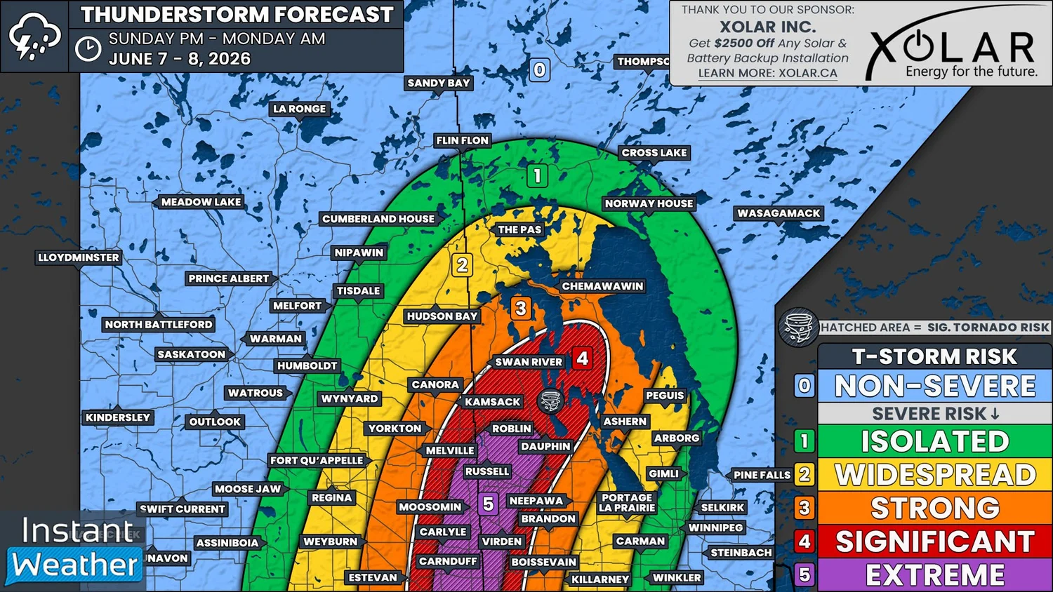
NOTE: YOU CAN CLICK ON THE MAP TO OPEN A ZOOMABLE IMAGE
After a busy day yesterday, that saw severe thunderstorms dropping massive baseball-sized hail over parts of Southeastern Saskatchewan and Southern Manitoba, we have the chance to do it all again today. It’s likely that today could be an even greater severe risk day than yesterday, with an extreme risk posed by the possibility of gigantic hail and multiple tornadoes. However, there has been a little bit of uncertainty surrounding how thunderstorms may end up developing this afternoon and evening.
Like yesterday, today’s severe thunderstorm threat will be triggered by a cold front that is currently oriented on a north-south axis and it located just west of the Saskatchewan/Manitoba border. This is a bit further west than originally anticipated when we issued our preliminary forecast on Friday, due in part to the front becoming stationary for a period of time yesterday. As a result, the severe risk today will cover more of Southeastern Saskatchewan and won’t extend as far east across Southern Manitoba.
To the east of the cold front, temperatures will once again climb into the low 30s this afternoon and it’s expected to be much more humid today, with dew points approaching the 20°C mark. The lack of moisture yesterday kept the cloud bases high, which greatly reduced the tornado risk, but it doesn’t look like that will be the case today.
The heat and humidity will lead to high levels of instability and upwards of 3000J/kg of CAPE to fuel thunderstorm development again today. Veering winds will also create a significant amount of shear to maintain large supercell thunderstorms.
Surface weather map with the positions of highs, lows, and fronts displayed as of 6am cst this morning, courtesy of the national weather service.
As we’ve mentioned in this forecast already, and in our forecast from yesterday, there was uncertainty with today’s severe thunderstorm risk. There have been some mostly non-severe thunderstorms that have tracked through Southern Manitoba already this morning and it is possible these could hinder additional development later today.
The storms have weakened over the past couple of hours and the thought was that if they manage to clear early enough, that will allow for there to be ample surface heating needed for the additional explosive development later. However, if the storms stuck around into the afternoon, the severe thunderstorm risk would be greatly reduced. With the clearing of these morning storms already occurring, it seems likely the severe threat will not be diminished.
The significant severe thunderstorms could develop in the late afternoon and into the early evening, around 4-6pm in Southeastern Saskatchewan and extending northeastward into Southern and Central Manitoba. These storms could once again explode into massive and dangerous supercell thunderstorms that would track roughly northeastward through the evening.
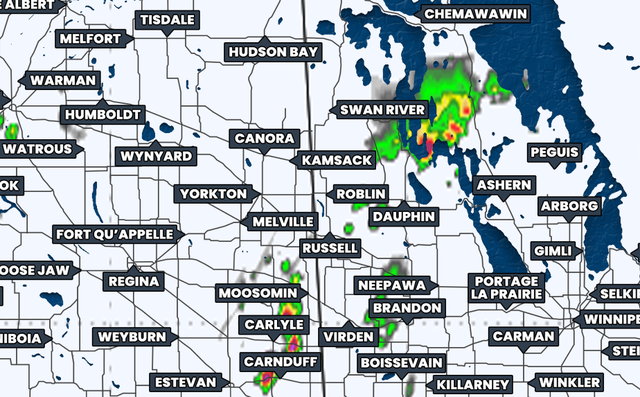
Simulated reflectivity at 4pm CST/5pm CDT, courtesy of weatherbell.
The area highlighted on our map in red, that covers a large portion of Southeastern Saskatchewan and Southwestern Manitoba, will be at a very high risk for dangerous severe thunderstorms. The area highlighted in purple, however, is where the strongest environment is expected to be and where there is an extreme risk for incredibly dangerous and life-threatening thunderstorms.
Throughout this region, the severe thunderstorms could end up producing absolutely massive, and maybe record-breaking, softball-sized hail, damaging wind gusts up to 120km/h, and very heavy rainfall that could lead to localized flooding. If we end up seeing the moisture that we were lacking yesterday, and the storm bases are lower, it is entirely possible that we could be looking at a tornado outbreak.
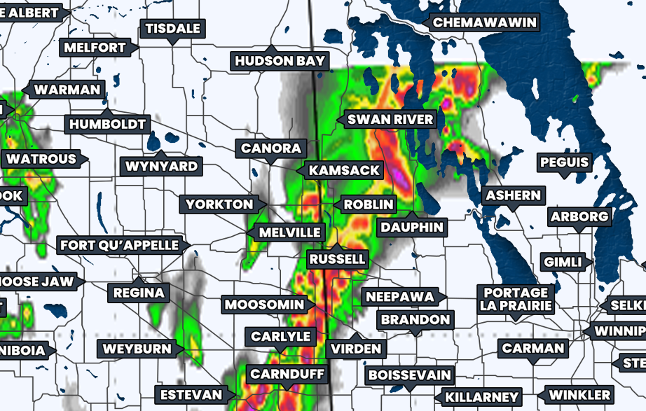
Simulated reflectivity at 8pm CST/9pm CDT, courtesy of weatherbell.
As we progress through the evening, more thunderstorms are expected develop and storms will also move into the region from south of the border. Once again, there is the likelihood that these additional storms will end up merging into a large line of storms which could impact a wide area into the overnight hours.
By the time we see a more linear storm mode, it’s likely that the storms will have weakened from their greatest strength, but they are still expected to be very strong and capable of producing very large hail, damaging wind gusts, and torrential rain.
The tornado threat should also decrease as we get later in the evening and into the overnight hours, but with how strong these thunderstorms could be today, there will still be a slight risk until the storms move into Northern Manitoba during the early morning.
Today’s severe weather threat is very serious. If you live in the area that we’ve highlighted in either red or purple on our map, PLEASE be prepared for the possibility of threatening weather to impact your area today. Make sure you have your phones charged and you have multiple ways to receive weather alerts. It’s also a good idea to have a plan in place in the event that you need to take shelter.
Once again, we will absolutely be live-streaming later so please join us while we monitor and track today’s severe weather. We hope everyone is able to stay safe today!


