Deep Freeze Continues Across the Prairies Thursday Night With Wind Chills Dropping Below -45°C
/
NOTE: if you click or tap on this image you can zoom in
Frigid Arctic air continues to blanket the Prairies, which has led to temperatures plummeting across the region. Dangerously low air temperatures and wind chill values will once again reach their lowest point of the day during the early to mid-morning on Friday, with many areas expecting to be colder than Thursday morning.
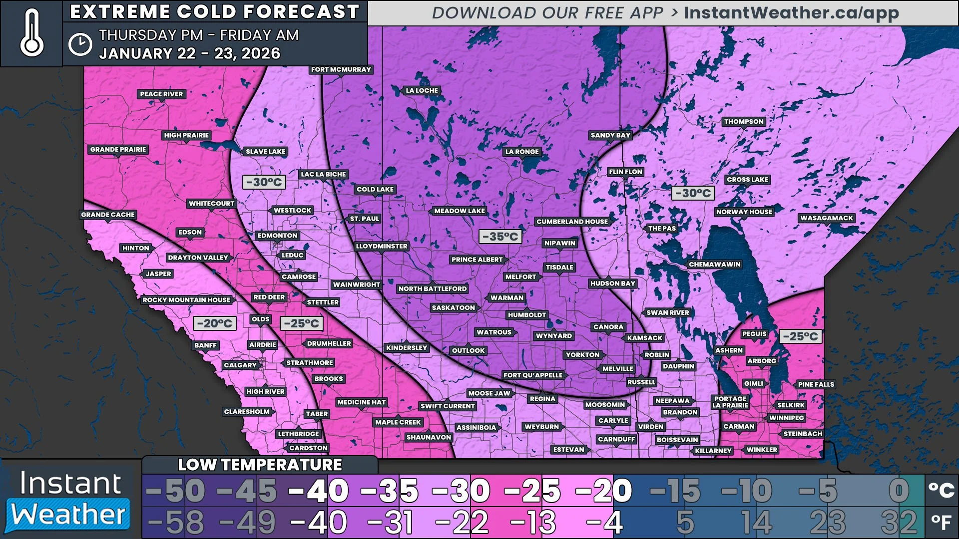
Air Temperature
Alberta can once again expect to be the most mild of the three provinces tonight and tomorrow morning, relatively speaking. However, it will be several degrees colder tonight and tomorrow morning. A majority of the province will see low temperatures drop into the -20°C to -30°C range. East Central and Northeastern Alberta will be in the colder air, with Edmonton falling below -30°C while Lloydminster and Fort McMurray are expected to dip below -35°C.
In Saskatchewan, the “warmest” air will again be found in the Southwest, where the lows are expected to range from -25°C to -30°C. A large portion of the rest of Southern Saskatchewan will drop to into -30°C and -35°C range Thursday morning. Further north, including both Regina and Saskatoon, temperatures will fall below -35°C, though they should stay above -40°C.
Manitoba will experience more variation in low temperatures Thursday night and Friday morning than overnight Wednesday. Much of the province is expected to bottom out between -30°C and -35°C. Slightly warmer air over Southeastern Manitoba, including in Winnipeg, will keep temperatures above -30°C. At the same time, some slightly colder air will nudge into the Parkland Region, bringing temperatures in Roblin and Russel just below the -35°C mark.
NOTE: if you click or tap on this image you can zoom in
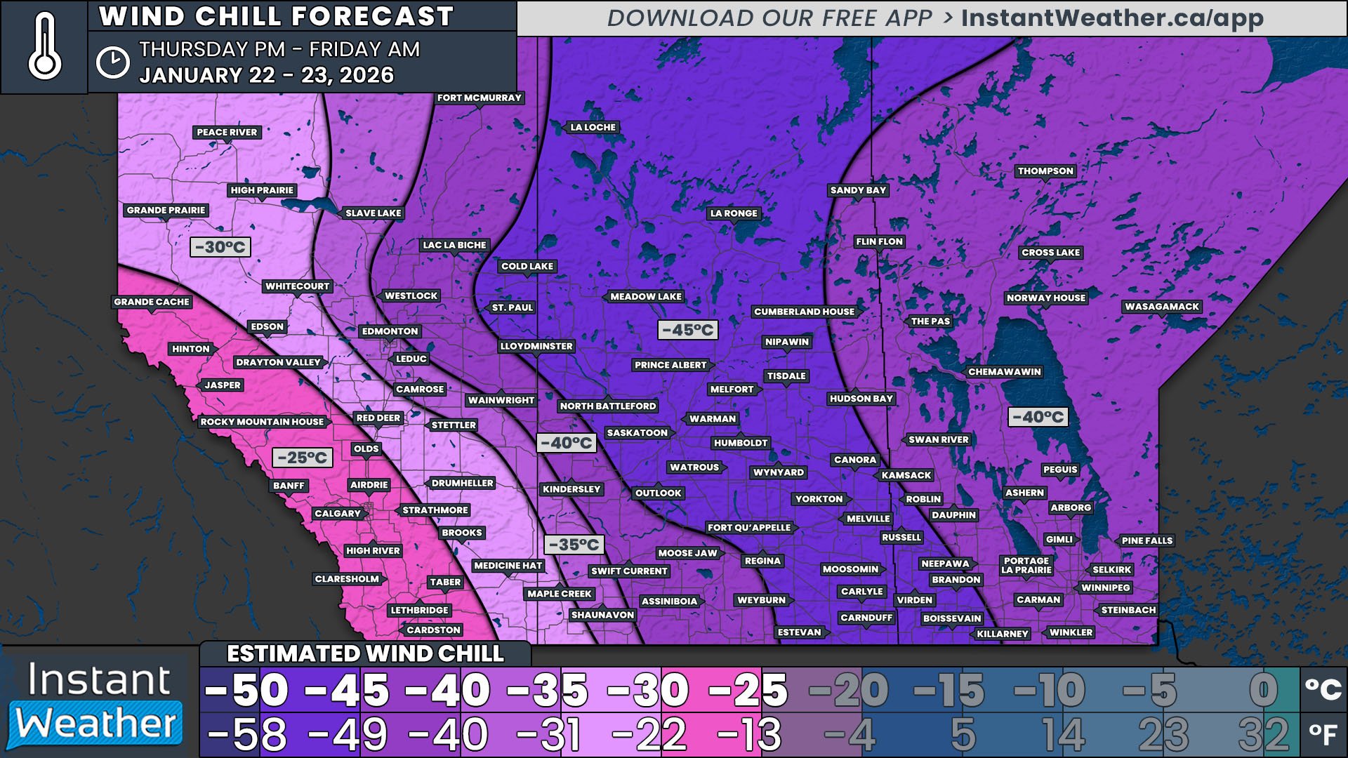
Wind Chill
Sustained wind levels will vary across the Prairies overnight Thursday and Friday morning. The winds will be fairly light across Alberta and Western Saskatchewan, ranging from calm to 15km/h, which will bring several degrees. The situation will be much more drastic in Eastern Saskatchewan and Manitoba. Here, sustained winds are expected to higher, at around 15-30km/h, and gusts up to 50km/h, which will drive wind chills much lower.
In Alberta, the comparatively milder temperatures will also translate to the least extreme wind chills, thanks to the light winds. Wind chill values will be approximately 5-10°C cooler than the air temperature, dropping steadily travelling northeast. It will feel colder than -25°C in Calgary and the Rockies, -30°C in Red Deer and Grande Prairie, -35°C in Edmonton, -40°C in Fort McMurray, and -45°C in Cold Lake and Lloydminster.
Most of Saskatchewan will be dealing with very harsh wind chill values Friday morning. Wind chills across much of the province, including Regina and Saskatoon, will make it feel colder than -45°C. Some weather models are even suggesting that the wind chill could possibly dip below -50° at times throughout Friday morning. There will be a slight reprieve in the Southwest, with Moose Jaw and Kindersley feeling like below -40°C and Maple Creek feeling like below -30°C.
Manitoba will see fairly uniform wind chill values, despite the increased variation in air temperatures. For most of the province, wind chills values will range between -40°C and -45°C. Wind chills will dip below -45°C in Southwestern Manitoba, where the winds will be the strongest.
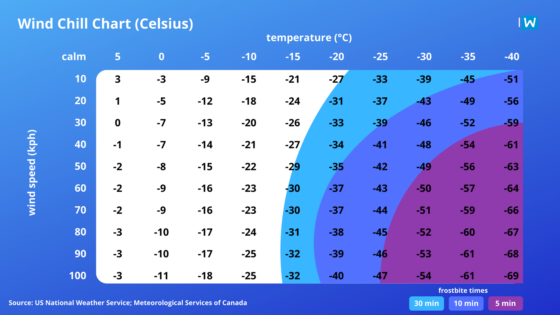
Wind chills values and frostbite times based on air temperatures and wind speeds.
With the wind chill values this low, it’s important to remember that frostbite can develop in as little as 10 minutes on exposed skin. Limiting time outdoors will be important, especially during the coldest part of Thursday morning. If you do need to be outside, dress in multiple warm layers and cover as much exposed skin as possible. Pets should be kept inside and it is also a good idea to keep an eye on any pipes that could be vulnerable to freezing during this prolonged cold.
This stretch of extreme cold is expected to continue for at least a few more days, with little relief during the day. It’s looking like we will be back into regular cold weather by Monday morning. In the meantime, we will continue share updates on just how cold it is expected to get.