Teddy To Pack a Punch Like Arthur or Juan! Down to Only Hours Before The Rain Arrives!

Updated: September 22, 2020 @ 9:16 AM

Valid: September 22, 2020 @ 9 AM

Forecaster: James Follette

Tropical Storm Teddy Impacts Map.jpg

Latest update and the potential impact threat!

Once again, the coastal areas are the ones that are at most risk for extreme impacts from storm surge, flooding rains, Tropical Storm to Hurricane force winds, rip currents, pounding surf affecting the beach & coastal erosion. This will be the area that will be a mess!

Further inland you go, the lesser the impacts. I'm thinking Western NS will only see a Slight to Moderate impact from heavy rain and gusty winds. Should not as bad as rest of the province but will be enough to cause some problems and power outages.

Southern Nova Scotia will see significant impacts. You're going to see those giant waves! Storm surge where it will be 50cm higher than normal, rip currents, and pounding surf. Those waves could be as high as 10-15 metres! And to top it off, heavy rains of possibly 40-50 mm in some places, which would even further flooding! And last but not least, you have the astronomically high tide!!

So flooding is one of the biggest concerns in that region, along with storm surge.

Then, you have the winds... If you’re closer to the track you will be in middle of the Tropical Storm force winds. Winds in these areas will gust as high as 105 to even 110 km/h, especially for towns in the Shelburne area, Clark's Harbour, Barrington Passage, and all the small islands and capes. They will be the ones to be beaten to a pulp more than any other towns in the South Shores.

Look for widespread power outages because there is still lots of foliage. The trees are going to be pressured and pushed really hard. They could fall and land on houses, cars, power lines and power lines could snap.

The only reason I didn’t put you on the Extreme Threat level is because of the winds should not reach over 110 km/h.

Be safe, everyone!

Hurricane Teddy to slam province with Tropical Storm force winds!

Updated: September 22nd, 2020 @ 7:45 AM

Valid: September 22nd, 2020 @ 8 AM

Forecaster: James Follette

Hurricane Teddy Wind Gusts Forecast.jpg

Here are the latest Peak Wind Gusts expected from Teddy.

Tropical Storm Force winds are winds 60 and above, and that will for sure be the case! however, lesser winds to the West where Gusts of only up to 80 km/h.

Closer to the coast, winds Gusting between 80 and 100 km/h, highest winds seems to be in NE Cape Breton where wind Gusts of 110+ is expected, and some models even suggest Gusts of near 130 km/h. Sustained winds in that area will be 90-100 km/h! These are winds that would create some serious wind damage, If there was any place to get the most damage and trees down it would very likely be North Eastern Cape Breton.

I am expecting some wind damage all along the coast, and trees and power lines likely be falling down as well along the coast.

~ James

Heavy Rain To Cause Flooding As Hurricane Teddy Arrives TODAY!

Updated: September 22nd, 2020 @ 6:45 AM

Valid: September 22nd, 2020 - September 24th, 2020

Forecaster: James Follette

Hurricane Teddy Rainfall Amounts.jpg

Good Early Tuesday Morning! and happy first day of fall! & Happy Birthday to my mother!

I continue to be hesitant on the rainfall for the South Shores & Tri-Counties, The GFS model wants to consistently continue with putting them at only under 20 mm, meanwhile the ICON & GEM model, as well as the ECMWF puts 30-40+mm.

For this Forecast Update, I am leaning towards the ICON & GEM model as ECMWF has track way to close to the Left, and the ICON,GEM & GFS have the track fairly well together crossing over Cape Breton.

I am not going by with the GFS for rainfall in SW & Cape Breton, as the track of system keeps rain further to the left, and strongest winds to the right.

So for Southern NS, expect 25-50 mm of rain

For Kentville, Bridgewater & Greenwood areas, 40-75 mm is expected.

For Northern NS, Amherst to New Glasgow, Antigonish, Truro and to Halifax you will see the heaviest rain! with amounts as high as 75-100+ mm

Cape Breton, Looking at 25 to 50 mm.

I will likely change this forecast this afternoon, if I see any changes and if the GFS is going as forecast.

Have a great first day of Fall!, Happy Birthday to my Mudder! and Stay safe out there and hunkers down & please for heavens sake! Stay the Blazes home!! ;)

~James

The Ghost Of Paulette, comes back from the dead!

Updated: September 22, 2020 @ 12:45 AM

Valid: September 22, 2020 @ 6 AM

Forecaster: James Follette

AL172020_5day_cone_no_line_and_wind.png

A new Tropical Storm has developed!!! Everyone, let’s welcome back Tropical Storm Paulette to the Maury show!

This is Paulette's 2nd appearance in the tropics! On the first appearance Paulette was a Storm that Got Angry at Bermuda and have pummeled them as a Hurricane. Only to find out later on that The cold north Atlantic waters was NOT the perfect water father!

She died, and now she is back! and she says that she think that the Azores is responsible!

So everyone Welcome back Paulette!!!

Paulette is a 60 MPH small storm heading East-North East at a speedy 16 mph.

Paulette is threatening the Azores, for potential landfall on Friday as a Tropical Depression, However there are other models that put Paulette to become stronger, and move south so we’ll watch her for a bit but she is no threat to any land mass in this country!

September 21 11PM Update on Hurricane Teddy & it's race towards Nova Scotia

Updated: September 21 @ 11:55 PM

Valid: September 22 @ 12:00 AM

Forecaster: James Follette

Hurricane Teddy Impacts.jpg

Good Evening! Here is the latest on the track and data on Teddy.

First here is what you need to know about Hurricane Teddy current data.

Hurricane Teddy is continuing to move Northward away from Bermuda and increasing in speed, now at a speedy 26 mph.

Teddy is a Category 1 Hurricane with 90 mph winds and is still expected to strengthen Tonight Before weakening again as it nears landfall in Nova Scotia.

Now to Latest track forecast. Teddy is expected to first make landfall over Marie Joseph, then cross through St. Mary's & Goshen then St. Andrew's between Antigonish and Heatherton. all through the day on Tuesday Evening into Wednesday.

After that it will cross over waters between PEI and Cape Breton as a Post-Tropical Storm.

Teddy should make landfall as a Post-Tropical Hurricane with Category 1 winds of 80 mph. There is still a slight chance though that Teddy could maintain Hurricane status just before making landfall.

Nevertheless, Tropical Storm Conditions are expected all over the province, and Tropical Storm Warnings and watches are in place.

There is also Storm Surge warnings, Rainfall warnings & Wind warnings.

If you have not done so yet, to prepare for the storm, you will only have a few hours in the morning to do so before Teddy rushes in.

Storm drains should be cleared, Vulnerable trees cut down, patio furniture, Trampolines, Garbage bins and other objects brought inside before noon Tomorrow!

Should also have your storm plan in place and ready, Generators, food, and chargers ready in case of Power outages.

Storm kits, Emergency plans, Evacuation plans should be ready and viewed over.

Instant Weather Meteorologists and Forecasters will continue to keep you posted through out the storm coverage before, during and after the storm.

Stay safe! and Hunker down, because we have another Arthur on our footsteps!

Teddy to bring risk of Isolated Severe Thunderstorms to the province, along with Tropical Storm Conditions

Updated: September 21st, 2020 @ 9PM

Valid: September 21st, 2020 @ 9 PM

Forecaster: James Follette

Thunderstorm Forecast Tuesday.jpg

While There are Storm surge warnings, Flood warnings, Wind warnings, Tropical Storm watches and warnings all in effect ahead of Hurricane Teddy that is ready to bare down on Nova Scotia arriving Tomorrow morning with rain then wind and the thick of it in the Evening and Overnight hours.

Along with the Stormy conditions, there will also be a risk of some Isolated severe Thunderstorms.

For much of Nova Scotia, there will be a risk of Non-Severe Thunderstorms, however where the storm center will cross, there is more energy, and so there could be a few ISOLATED Severe thunder storms that could produce some large hail, Frequent Cloud to ground lightning, Strong wind Gusts on top of the Tropical Storm Force winds.

Teddy Paying a Visit to PEI

Valid: Tuesday September 22 to Wednesday September 23, 2020

119715892_702893467327800_7717816637776709119_n.png

Well good evening Prince Edward Island. As many of you are aware, Teddy is going to pay a visit to our Island on Tuesday and Wednesday. There has been a lot of speculation as to the impact this will have on the Island and we will do our best to let you know what we are seeing.

The track of the system a couple of days ago was trending off the east coast of Cape Breton. The latest model runs seem to have the centre of the low staying east of PEI.

This system will start on Tuesday mid day and we will see it finally move out of the region Thursday early morning. Here is what the models are currently indicating:

WINDS

The winds will start to increase after noon on Tuesday.

Across the Island we will see sustained winds of 40-60 kmh with gusts up to 70-90 kmh. The higher wind gusts will be after supper into the evening. Winds will diminish after midnight.

Wednesday:

Winds will again start to pick up mid morning and we will see sustained winds of 40-60 kmh with gusts again in the 70-90 kmh range. Winds from the system will remain high until around midnight on Wednesday night before we start seeing them diminish and move out of the region totally by noon on Thursday.

RAINFALL

Total rain accumulations with this system are approximated to be:

Tuesday:

Prince County: 15-25mm

Queens County: 25-35mm

Kings County: 35-45mm

Wednesday:

Prince County: 15-25mm

Queens County: 25-35mm

Kings County: 35-45mm

With the foliage still out, the rain and the winds may cause trees to be uprooted. Please heed the warnings of all safety personnel. Ensure you have your emergency preparedness kit ready should you experience a power outage. It is quite likely that power outages may occur across the region.

Please be safe and let us know what you are experiencing in your area.

We will update you as the system moves across the island and if anything significantly changes.

Storm Chip Probability: 95%

Thanks and stay safe.

IWPE: Harry and Mike

Teddy weakens to Category 2 with 105 mph winds, still on course to make direct hit on Nova Scotia

Brief Tropical Update # 1 Issued @ 11:23 AM

Valid @ 12:30 AM

Forecaster: James Follette

TROPICAL UPDATE.jpg

The latest update in from the NHC as of 8 AM, is that Hurricane Teddy has weakened to a Category 2 Hurricane with winds of 105 mph or 169 km/h. Pressure has also risen from 958 to 964mb.

The storm has also made a more of a jog towards the West more but still going in a NW direction to make the path now a WNW, with no change in speed at 12 mph.

simuawips (3).png

Despite the weakening of the system and a more westerly track, Teddy’s track has little to no change to it and Teddy is still on course to make landfall in Nova Scotia on Wednesday somewhere between Northern NS and Cape Breton.

The wind Radii ( Wind Field) still puts Tropical Storm force winds (60km/h SUSTAINED, not Gust) as far as Central New Brunswick, PEI, & Maine as shown in the graphic. Strong Tropical Storm Force winds ( 90 km/h or greater Sustained) is expected to occur over much of Nova Scotia from Cape Breton to Clark’s Harbour.

Western NS as of the latest update looks to escape the Strong Tropical Storm Force winds. This includes Yarmouth County, Digby County and the rest of Western NS. Winds in these area may not be Strong Tropical Storm Force, but they will still be Tropical Storm Force and so Wind Damage is still expected. Winds will be sustained of 60+ km/h with Gusts to 100 km/h.

Areas in Orange who will see Strong Tropical Storm Force will see Sustained winds at nearly 100 km/h with Gusts at Hurricane force potentially between 120 and 140 km/h.

Life Threatening Rip currents and Surf will continue to increase through the next several days, and the waters will be extremely dangerous all of next week, due to 2 other Tropical systems and a developing system to the North and the size of Teddy.

Very large waves will also increase in magnitude today and into Wednesday and Thursday.

Any boaters or fisherman, ship vessels are asked to take extreme caution as Hurricane conditions will continue in the open waters and for boaters closer to the coast, it’s highly recommended that you secure your boat Very tightly, or bring it on land.

  • As mentioned earlier, this is the time to prepare now as early as you can before Tuesday morning.

  • Cut down old weak trees that are capable of falling on wires, cars or houses

  • Trees with foliage being battered by Tropical Storm Force winds of 60+ sustained and 100 km/h Gust has the highest chance of breaking or falling down on wires, and with this said we expect several numerous trees down and lot’s of power outages similar to Tropical Storm Arthur.

  • Stock up on small food items for a few days incase of power outages

  • In case of power, be best to buy a Generator if don’t have one

  • Go through your Emergency storm kit

  • Go through your Hurricane Aid Kit

  • Go Through your Evacuations Hurricane Plan ( for those living right near the water)

  • BE SURE to clean the storm drains! so that water can flow freely down the storm drain to reduce the threat of flooding.

  • Be sure to have a weather radio and to keep checking regularly for new updates!

  • Check in on your family, friends and elders

Hurricane Teddy Update #1

Forecast Updated at September 20th @ 10:20 AM

Forecast Valid September 20th @ 11 AM

Forecaster: James Follett

TROPICAL UPDATE.jpg

Good Sunday Morning! This is Instant Weather Tropical Update #1 on Hurricane Teddy as it heads for Bermuda and Atlantic Canada.

As of the 5 AM update on Hurricane Teddy, Winds have dropped to now 105 MPH making it a Strong Category 2 Hurricane and it is now jogging to the WNW at 12 MPH and is expected to turn more Northward later today. The pressure has risen substantially to 964mb up from 958 just 3 hours ago.

Teddy's evolution for the next few days appears to be a tale of 3 troughs. Upper-level westerly flow associated with the first upper-level trough, affecting the storm now, is the most likely reason why the hurricane's structure has degraded and has taken on a slightly sheared appearance. Teddy will begin to encounter the 2nd trough, a deep frontal system approaching from the west, later today and that should cause the hurricane to turn north. This interaction should steer the center of Teddy east of Bermuda, but tropical storm impacts from either the large hurricane, the frontal system, or both are still likely Sunday evening through Monday night.

All indications are that Teddy will then continue generally northward and merge with the frontal system, nearing Nova Scotia as an extratropical cyclone early Wednesday. Teddy's maximum winds will likely decrease sharply after it becomes post-tropical, as shown by all the intensity guidance, but its gale and storm-force wind radii will likely increase at the same time. The cyclone should turn northeastward as the 3rd trough, another mid-latitude system, approaches from the west. Teddy could be absorbed by that feature in as soon as 120 h, though this is not explicitly shown in the forecast at this time. The spread in the track and intensity guidance is quite low and confidence in both aspects of the forecast is high. There is a little more uncertainty in the wind radii evolution, but it is clear that Teddy will produce strong winds over a wide area of the northwest Atlantic during the next couple of days.

The extent of 12-foot or higher seas associated with Teddy continues to increase. See the Key Message below regarding swells caused by the hurricane.

We now know more on the highest most likely impacts it will have on the Province of Nova Scotia and the rest of Atlantic Canada.

Hurricane Teddy’s Impacts On Nova Scotia

Hurricane Teddy Impacts.jpg

Highest threat of Hurricane and/or Tropical Storm conditions are Flooding & Wind damage. Where in many areas of the province sustained Tropical Storm force winds of 60-70 km/h will Gust up to 100-110 km/h and with lot’s of foliage on the trees, that will put more stress on the trees and will then break and/or fall, and these can fall on cars, power lines creating power outages. But also flying debris such as roof shingles, house sidings, signs, flower pots, Patio furniture, trampolines the biggest one!.

If you have any small objects that are light that can blow away and create damage, you have until Tuesday Morning to get it done! Things that should be brought in or taken down includes Flower pots, Patio furniture, Trampolines, etc.

Along with objects, it is very important that you cut down any potential tree branches that are old or look weak that has the potential too fall down on the house, or car, this can be done up until Monday Night.

After noon time on Tuesday, time will be up and all bets are off, as Tropical Storm force winds arrive shortly after noon hour, Rain at times heavy begin over Eastern NS and South Shores Tuesday late Morning between 9 and 11 AM.

The next threat then is the flooding, which will be a very big threat for much of Eastern NS and Northern NS with up to 100 mm is expected, further South the amounts are less where only up to 30 mm will fall regardless of how much rain falls, torrential tropical downpours can cause flash flooding, as well as Street, coastal and urban flooding. It is very important that you clean up the storm drains on your street next to you, flooding becomes fast all the time when storm drains are clogged and water cant fall down. This must be done before Tomorrow Night.

Other types of flooding includes Coastal flooding, low lying areas near the water can get severe flooding from Storm surge, and to make things worst is that this storm comes on a night of Astronomical High Tide. Big waves of over 12ft, giant surfs, storm surge and the high heavy rain amounts will cause extreme flooding threats for communities near the water all up and down the coast of Nova Scotia, with exception to Bay of Fundy where land interaction and opposite wind direction will create a lower flooding threat.

Beach erosion is also very likely along all ocean facing Beaches.

Tornadoes… As with all Tropical Cyclones, there is the risk of Tornadoes because of the circulation. how ever the threat for Tornadoes are very low as there will not be much convection as storm weakens.

Hurricane Teddy Wind Field

Hurricane Teddy Wind force.jpg

Correction: Tues, Sept 22nd*

The current track of Teddy puts it heading for extreme Eastern Cape Breton, around Sydney. However as the Hurricane tracks North on it’s way over the next few days and transitions to Post-Tropical the Wind Radii begins to expand, so even though the center of storm may be far offshore, the Tropical Storm Force winds and Tropical Storm conditions will spread all through Southern, South Shores and Western Nova Scotia beginning Tuesday Morning into Wednesday Night.

For Northern Nova Scotia & Cape Breton, The storm will pass very close and will intensify just a little, producing Hurricane force winds that may reach the area, never the less the area will still see Tropical Storm force winds sustained.

Power outages very likely!

Power Outages Forecast.jpg

Correction: Tues, Sept 22nd*

Wide spread Outages can be expected through Southern Shores, Northern NS, & Eastern Cape Breton.

Outages that are likely or very likely covers a big area of the province. much of Tri-Counties up through Halifax and Northern NS into New Glascow as well as Western Cape Breton, for Eastern NS, and parts of Kings and Annapolis Valley will see some possible Outages through Wednesday Night.

Hurricane Teddy Rainfall Intensity Forecast

Hurricane Teddy Rainfall Intensity Tues. Morn-Aft.jpg

Rain will start Early to Mid Tuesday morning, Moderate rain will come from the East, a more lighter rainfall for Western side of the province, as well Cape Breton.

Hurricane Teddy Rainfall Intensity Tues. Eve-Ovr.jpg

By the time we get into the Evening and Overnight hours, we’ll see Moderate to Heavy rain much of province except for Northern and Cape Breton, where very Heavy rainfall is expected, look at 20+ mm/hr rates

Hurricane Teddy Rainfall Intensity Wed. Morning-Afternoon.jpg

By Wednesday, the rain and heavy rain continues especially if in Eastern, Central & Northern parts of the province. By time we are at mid day Wednesday we will have very heavy rain that have rates of 30+ mm/hr, this is where you 70-100+ mm totals come from.

Hurricane Teddy Rainfall Intensity Wed. Evening-Overnight.jpg

By Wednesday Evening into the Overnight, much of the province will see the rain shut off, however some light to Moderate rain continues over Western Cape Breton from Antigonish to Sydney.

Hurricane Teddy Rainfall Intensity Thursday Morning-Afternoon.jpg

As the system pulls away heading for the Island of Newfoundland, still will be a few left over showers over Eastern Cape Breton.

Thunder Storms Likely Tuesday & Wednesday!

Now with Heavy rain, and a lot of Energy and this is a tropical System.. How about Thunderstorms? yup they’re a possibility!

Thunderstorm Forecast Tuesday.jpg

On Tuesday, the entire province has a Isolated Severe risk of Severe Thunderstorms.

Thunderstorm Forecast Wednesday.jpg

Now on Wednesday, as the storm pulls North, we’ll see a Severe risk of Thunder storms and Isolated in Cape Breton!

Teddy’s Impacts!

Tropical Storm Teddy Impacts Map.jpg

Correction: Tues, Sept 22nd*

The biggest impacts will be in Cape Breton as that is where the center will track. but much of the province will see a big impact! From Yarmouth to Antigonish expect Significant Impact, This also includes Digby and Greenwood!

Then Kentville, Amherst, New Glascow, Truro will a lesser impact, but still a Moderate Impact to winds and rain, but not so much storm surge.

Teddy’s Rainfall Through Thursday Morning.

Hurricane Teddy Rainfall Amounts.jpg

Correction: Tues, Sept 22nd*

For Southern, Southern Shores, Annapolis Valley, Kings counties, much of Eastern Cape Breton. You will see the least amount of rain, do to the fast speed, so a wind issue rather than rain. However that is not to say you won’t get anything!! 15 to 30 mm is in the forecast, and there could be some local amounts of 30-40 mm . For Halifax, Halifax Metro, Truro, Amherst. Look at 25 to 50 mm with locally 50 to 70 mm. This is where the Flooding threat is expected. For New Glascow and and surrounding areas, 40 to as much as 75 mm! and you could have locally some amounts approaching 100 mm. Antigonish and remaining areas, look for the heaviest rain, to create severe flood risk, 75 to 125 mm of rainfall with locally some amounts approaching 125 mm.

Teddy’s Winds Through Thursday

Hurricane Teddy Wind Gusts Forecast.jpg

Correction: Tues, Sept 22nd*

A wide swath of the province will see winds between 80 and 100 km/h Gusts. Cape Breton is exception, where they will see the most winds! of Winds Gusting to 110+ km/h , least winds can be found in Western sections such as East of Kentville, Truro, Kentville. winds Gusting 80 to 95 km/h which is Tropical Storm force, anything over 60 km/h is Tropical Storm force.

Teddy’s Hazards

Hurricane Teddy Hazards.jpg

Damaging Wind risk is fairly high! along with Severe weather and Travel can be quite Significant. Flood risk is Moderate to High and the Confidence on the forecast is a bit better now at 75-100%, which is pretty good, however still a few things needs watching that can change the system.

What to do! and How to Prepare!

The Storm is now only about 48 hours away, and with the very high likely hood of a dangerous direct impact on the province. It’s time to prepare! and Go over the Emergency Preparations

What to do before the Hurricane arrives!:

  • Get water, Bread, can food that will last up to 3 days.

  • Buy a Generator!

  • take down old, weak large tree branches that has potential to fall down on your car or house.

  • clean up near the storm drains, make sure there is plenty of room for the water to flow down.

    What to Have during the storm and what to go over:

  • . A flash light

  • Batteries

  • Weather Radio

  • canned food

  • An emergency kit

  • Gas ready in car

  • Money

  • Generator for long lasting Power Outages

You Should be going over the Hurricane kit and Emergency plan with the family.

  • Go over what to do before, During & After the Hurricane or Tropical Storm.

  • Have a Emergency Aid kit! and go over the items with the Family

  • Have an Evacuation Hurricane Plan!! For those living near the coast, where severe flooding and beach erosion is very likely, Coastal evacuations may be needed, Go over what to do in the case of an evacuation

    AND MOST OF ALL….

  • Stay Calm!!!

  • Pandemic rules still apply!!

  • Keep a distance of 6ft!

  • Wear a Mask!!

  • Wash your hands frequently!

Be Safe! and have a great Sunday Morning

  • Next Update is at 4 PM

Warm & Wet Weekend Across Southern Ontario With Temperatures Into the 20s and Up to 20–40mm of Rain on Sunday

Valid: Saturday, September 12, 2020 - Sunday, September 13, 2020

It has been a fairly mild and in some cases, chilly start to fall across Southern Ontario with multiple nights of frost advisories in the more northern areas of the region. Thankfully we aren’t talking about the other f-word just yet and that appears to hold true for at least the next few weeks.

In fact, we’re looking at the exact opposite with much warmer temperatures expected this weekend with the thermometer reaching into the 20s on both days for some areas. For Sunday, the warm temperatures will also be accompanied by heavy rainfall beginning early in the morning and lasting throughout the day. Thunderstorms are also possible in some areas which will increase the potential rainfall totals with local amounts up to 40mm.

On Saturday we will see temperatures ranging from 20-25°C as daytime highs through regions south of Lake Simcoe and out into Eastern Ontario along the international border. Central Ontario and Northeastern Ontario will be slightly colder with daytime highs between 15-20°C.

Moving onto Sunday we will see even warmer temperatures than on Saturday with the 20-25°C zone including much of Southern Ontario. Only very northern parts of Central Ontario and Northeastern Ontario will see a daytime high of less than 20°C. A corridor extending from Extreme Southwestern Ontario and into the Golden Horseshoe could see temperatures reach into the mid to high 20s although this isn’t guaranteed and could very well stay between 20-25°C.

As mentioned, Sunday will also bring the potential for heavy rainfall throughout the day beginning just after midnight. The focus will be a zone to the east of Lake Huron and Georgian Bay where a particularly heavy band of rain could affect the region Sunday morning. This will clear up around noon, but another zone in Eastern Ontario including Kingston and Brockville could also see heavy rainfall during the early afternoon. Other areas will see scattered rain and showers throughout the day with the highest chance earlier in the day and clearing up by the evening.

Rainfall totals will generally range from 10-20mm by the end of the day. Although a few localized spots especially in the aforementioned regions could see between 20-40cm as shown in the orange on the map below.

As we start of a new week, we’ll see temperatures cool down slightly with daytime highs in the mid to high teens. It will only get colder the further we go into the week with the potential for frost returning in the higher elevations by Thursday and Friday. It looks like this may be one of the last real burst of heat left this season before we get deep into fall and yes, winter.

+ Attribution

Icons made by Good Ware from www.flaticon.com
Icons made by Freepik from www.flaticon.com

Scorching Heat Continues, Cool Down in the Forecast & Even Some Showers!

BC Afternoon Forecast Update

Issued at 2:00 PM

Valid: Thursday, September 10th, 2020 at 2PM

BC Thursday Temperatures.jpg

Good Afternoon on this gorgeous Thursday! nearing the middle of September. The heat will continue for much of British Columbia, especially the southern areas as High pressure remains in control funneling in that hot air from the desert and California, along with that some thick smoke from forest fires across much of southern BC, including Vancouver and Vancouver Metro.

A High pressure ridge will continue to bring some far above normal temperatures into the low and mid 30’s for much of the southern half of BC.

The High pressure will continue to move Northward moving over Northern BC by the weekend, A Low pressure trough will move in by Sunday to bring rather cloudy skies to much of BC. Skies will clear a little Sunday Night into Monday, but humid pacific air will fuel some potential Showers and thunderstorms over Vancouver on Monday & Tuesday.

High pressure remains over the province on Wednesday, but will begin to push off through Wednesday evening as a Low pressure off the coast will move in on Thursday.

Temperatures look to get very hot again by Wednesday, will be short lived as cooler and more wetter conditions look to stick around for several days after Thursday.

BC Friday Rainfall.jpg

Rain showers will slide down from the Northern Rockies, A wet weekend is expected with light showers arriving on Friday and lasting through the weekend.

BC Saturday rainfall.jpg
BC Sunday Rainfall.jpg

Showers will become more moderate and widespread as we end the weekend. As of now the rain looks to stay far north and west of Prince George.

BC Total Rainfall this weekend.jpg

Total rainfall amounts are fairly light, 5 to 10 mm is expected, there is also a few local areas that may see locally 10 to as much as 15 mm.

For everyone else, it is dry all the way into next week.

BC Thursday Humidex.jpg

Biggest story besides some rain finally coming is of course that heat, a giant area of BC will see high humidex feel like temperatures into the 30’s to near 40. Hottest will be Naniamo & Vancouver to Whistler and Salmon Arm and south to Penticton. These areas could see humidex readings around 35 to 38, rest of Vancouver Island and areas further north looking at 30 to 35 for humidex, and elsewhere looking at feel like temperatures up to 30 degrees.

Vancouver 7 day.jpg

Looking at the Vancouver Forecast for next 7 days, Another scorcher today, far inland reaching 34 degrees, again humidex making it feel close to 40, cooler on the coast near 30, but still hot even for being near water. Clouds increase a little bit tomorrow with much cooler air! highs in the mid 20’s, still above normal.

Weekend looks somewhat ok, sun & clouds on Saturday and highs in the low to mid 20’s, cloudy skies Sunday and cooler at 22, that’s your coolest day of the week!

Showers!!!! with some sunshine arrives for the new work week, also be humid! highs of 25 and 26 and we keep climbing on Wednesday with sunny and hot skies. highs back up to around 30!

So, If you don’t like the heat, there is a cool relief coming, but it warms up again next week!

BC September Heatwave to Likely Break Records, Pattern Change Next Week!

Wednesday Morning BC Forecast Update

Issued: 6:00 AM, Wednesday, September 9th, 2020

Valid: Wednesday, September 9th, 2020.

Forecaster: James Follett

xx_sat-en-193-0_2020_09_09_12_50_1621_486.png

Good Wednesday Morning! on this early beautiful morning! Gonna be a gorgeous morning out there for a walk or early jog before school or work. Have the AC on full blast folks because it’s going to be a scorcher folks!! We will have wall to wall sunshine all thanks to a Big blue H, our fair weather friend.

This ridge goes far north of the province, and so expect the same kind of weather for several days, with record breaking high temperatures for many much of the week! especially if you’re in the Interior.

Looking above at our Top Alert Super HD Satellite, we have a few mid level clouds bringing a bit of drizzle or light mist and fog to the far north over the ridge, and some clouds over Northern Haidi Gwaii but overall it’s basically crystal clear out there! it’s clear as a bell.

xx_obs-en-193-0_2020_09_09_11_00_1621_101.png

Taking a look at the percentage of cloud cover, as can see almost everyone is seeing clear skies!! which is 0%, some locations under overcast skies at 100%, but the theme here is side to side, top to bottom it is nothing but stars! and a beautiful sunrise.

Taking the kiddos out to the bus stop this morning?? Here is a look at the latest Bus Stop Forecast!

School Bus Forecast  Vancouver Metro.jpg

There is nothing to complain about at the bus stop except that it may be a little cool, so bring a very light jacket just for the morning, but dress in sandals, shorts, t-shirt and hat and sun glasses because it will be a oppressive major heat, and many locations, more so the Interior will see another heatwave which is 3 days of consecutive 32*C or greater.

So at the bus stop, 10*C is the temperature between 6 and 8 am, look for nothing but sunshine, light winds! Those winds will however increase just a tad to the West at the late end of the day, on the bus home along with the near 30 degree weather.

And with the extreme heat, we do have alerts issued regarding heat!

  • Central Coast -Inland sections

  • East Vancouver Island

  • The Fraser Canyon

  • The Fraser Valley

  • Greater Victoria

  • The Howe Sound

  • Inland Vancouver Island

  • Metro Vancouver

  • The Nicola

  • The North Coast-Inland Sections

  • Okanagan Valley

  • The Shuswap

  • Similkameen

  • South Thompson

  • The Southern Gulf Islands

  • The Sunshine Coast

  • West Vancouver Island

  • and Finally Whistler!

    These areas can see Extreme heat that is going to be at least 10 degrees or more above average and Temperatures peeking over 25-30*C with out humidex.

    We also have a Air Quality Advisory issued for the smoke coming from the states covering much of the Southern BC area.

  • Arrow Lakes to Slocan Lakes

  • The Boundary

  • East Kootenay

  • East Vancouver Island

  • Fraser Valley

  • Greater Victoria

  • Howe Sound

  • Inland Vancouver Island

  • Kootenay Lake

  • Metro Vancouver

  • Okanagan Valley

  • Similkameen

  • The Southern Gulf Islands

  • The Sunshine Coast

  • West Kootenay

  • West Vancouver Island

  • Whistler

This is for bad air quality due to forest fire smoke which continues to cover much of Southern BC, If you have bad respiratory problems like asthma, today be a great day to stay in.

As for the Heat, if heading out, drink plenty of fluids, dress in light clothing, wear sunscreen, ignore the sun from 10-4 and check on your elderly, and family members also, please do not keep children and pets in cars!

BC Wednesday Temp Forecast.jpg

Highs today, a very large swath of much of BC will see highs today in the 30 to 35 degree range, this includes Vancouver Island, much of the Interior and southern sections all the way up to Williams lake and as far north as near Kitimat, This is where the hottest temperatures will be.

For Kitimat, Terrace, Smithers, Prince George to Quesnel and Salmon Arm, look for 25 to 30 degrees today, so still a very warm one!

For The Mountains and Northern Rockies and border into Alberta, look for temperatures of 20-25 today.

Now when you factor in a little bit of humidity…

58BC75BB-647B-4FEB-9C3D-59D863DFEEE8.jpeg

These are the forecast Humidex values for today, this is what it will “FEEL LIKE” Smithers to Naniamo and all the way to Salmon Arm, a very big coverage area of red, this is 30 to 35*C humidex readings. for Hope, Penticton and possibly Victoria. look for the hottest humidex readings of 35 to 40*C. Prince George and the Rockies looking at 25 to 30*C humidex readings. Now Quesnel, you may notice is somewhat very close to the dividing line of 25 to 30 and 30-35, the western side should see 30+ humidex while the East side will see up to 30 degree humidex.

Vancouver Hourly forecast.jpg

Here is a look at your hourly forecast starting this morning at 11, we’ll be nearing 20 by noon time and by supper hour with full sunshine, highs today will make a run in the upper 20’s to near 30, again with humidity it will feel like the low to mid 30’s. by 9pm we’re down to 24 and still warm at midnight at 20 degrees.

BC Long Range Outlook.jpg

If you do not like the heat, well then you may want to stay in a AC conditioned room or the basement because it is going to be hot and dry for next several days. in fact much of this week will be sunny and hot.

However to the North, North of Prince George, there is going to be some increasing clouds for the weekend and beyond from a back door cold front.

Also some clouds moving in after the weekend for Vancouver, but it stays dry and warm right through until next Wednesday.

After that! we have a potential weather pattern change where a series of storms will come slamming into the BC coast bringing lot’s of rain and some fairly strong winds. It still to early to say for sure though! but it does look more and more likely we will have a more unsettled weather pattern, and much cooler too! by mid next week!

Until then.. check out these Temperatures for the week in Vancouver and Metro!

Vancouver 7 Day Temperature Trend.jpg

Look at these temperatures!! Today, highs up to 33 in the inland and warmest spots, 34 tomorrow! then we drop down quite a bit! down to 28 on Friday, which is still very warm for this time of year! 25 on Saturday, 22 on Sunday, Monday 23 and 22 Tuesday. So we begin to see a more comfortable airmass once we get pass the weekend, but until then we’re in the oven.

Vancouver Weather Grade.jpg

Weather Grade today, an A- now I could give it a A+ or A++ but, the heat is a bit to hot to give it some good credit! other than that though, light winds, lot’s of wall to wall sunshine. Winds becoming Westerly 5-10 km/h late in the afternoon, and humidity levels almost near 50%.

Regional Forecast Interior to Fort St. John.jpg

Forecast now for the Interior, Peace River and Fraser to Fort George areas.

Kamloops, looking at highs of 31 today, 34 tomorrow, 35! on Friday, cooling down to 32 on Saturday and a cloudy 33 on Sunday. a hot one in the Desert! Nothing but full sunshine through the weekend.

For Prince George Wednesday, Thursday Sunny skies! and mid 20’s, clouds increase by Friday into the weekend. highs in the low to mid 20’s, normal is 17 this time of year!

For Fort-St. James area, Sunny skies today & tomorrow, highs in the low to mid 20’s, clouds increase Friday into the weekend and highs into the low 20’s, still warmer than average! which is 17!

For Fort-St. John area. Sunny skies today and tomorrow with highs in the low to mid 20’s, normal is only 16! we get back to normal on Friday with 16 degrees and showers, rain on Saturday and 15 and look at this! Cold and wet and a possibly a tad white? looking at a potential rain/snow mix early in morning then rain. cold!!! highs ONLY at 8 degrees.

Regional Forecast Kootenay's & Okanagan's.jpg

Moving on now to the Kootenay’s & Okanagan regions.

Hope, Kelowna, Osoyoos & Warfield! looking at sunny skies and blazing heat! for next 5 days. some small clouds on Sunday in Hope.

Highs of 33 today, 35 tomorrow and 30 Friday then down to the upper 20’s at 27 and 26 for the weekend in Hope.

For Kelowna. Sunny skies all way into the weekend! highs of 30 today, 33 Tomorrow, 34 on Friday, 32 on Saturday & Sunday.

for Osoyoos, Sunny skies through the weekend, 31 today, 33 Tomorrow, 34 on Friday, 33 Saturday and Sunday!

and for Warfield… the normal for you is a balmy 24 this time of year, and check out this forecast! sunny skies all week and highs of 30 today, 33 tomorrow. Not hot enough yet? how about a 36! on Friday, then 33 Saturday and 34 on Sunday.

So for the Desert areas, looking at a prolonged summer stretch of record heat.

Vancouver Metro This Afternoon Forecast.jpg

For Vancouver now, Sunny skies this afternoon! highs of 28 to 33 in the region. Westerly winds light becoming 5-10 from the West later this afternoon. records likely to be broken!

Vancouver & Metro 24 hour Forecast.jpg

Next 24 hours, looking at hot sun today and 33 in the hottest areas, down to 13 tonight under clear starry skies.

Vancouver 7 day.jpg

Here now is the 7 day for Vancouver and Metro. 33 today, except cooler 28 near the water. 34, tomorrow under more sunshine. near 30 by the waters. cloudy skies on Friday and 28, 25 on Saturday and partial clouds, clouds and cooler on Sunday at 22, 23 on Monday under partial clouds and clouds and 22 on Tuesday. then beyond that it looks like rain and wind returns for Wednesday. Turns breezy as well on Sunday afternoon through mid week!

That is your Early Morning Forecast Update

Have a great Wednesday, Stay safe please wash your hands, wear a mask and keep a safe distance of 6ft!

A Swift change coming to BC following after a Early September Heatwave

Issued: Monday, September 7th, 2020 at 4 AM PT

Valid: Monday, September 7th, 2020

Forecaster: James Follett


After many British Colombians have been enjoying prevailing sunshine and basking heat that was a real treat which is more typical for July and Early August. A big change in the weather will come for Today Monday, September 7th.

For folks in the Interior, Okanagan, and Kootenays. where it’s been almost a week of 30C+ temperatures and lot’s of sunshine, you will wake up to fairly Gusty winds to 70 km/h, except up to 90 km/h for extreme southern sections of the Okanagan desert and Interior from Whistler to Hope and up to Penticton. and a fairly much cooler day with temperatures 5 to 15 degrees cooler than have been experiencing. Highs are only expected to be in the 20-25 degree range, which is right around average for this time of year between 20 and 22 degrees. The good news is that with the Gusty winds and cooler Temperatures is that there will be sunshine!!

For folks in Vancouver, Vancouver Metro, Vancouver Island, Victoria and all along the BC Coast, you have also been spoiled with warm basking sunshine! and here is the good news! The heat will continue for you! in fact it might be even hotter than yesterday, many areas flirting with 30*C, winds will also be Gusty up to 70 km/h.

For folks in parts of Central spreading far North from North of Kamloops to Williams Lake, Quesnel, and past Prince George, you can Cooler temperatures of around 15 to 20*C, but also will see the least Gusty winds, winds Gusting up to 60 km/h, however there are many locations that may not even get winds Gusting past 40 km/h.

For folks in the Columbia Mountains & Coast Mountains, you will be dealing with a very chilly day! Cold air, typical of Late October and early November will flow down from the mountains & Rockies, Highs only around 5 to 10*C and there might be quite a few locations that may not even get above 5*C, as for winds the Coast Mountains will see Gusts up to 80 km/h, and there could be a few isolated locations getting near 90 km/h. The Columbia Mountains will see small Gusts of up to 60 km/h.


Discussion:

A very large and intense trough of Low pressure located over Northern Ontario is digging far south to a point where it is going to do a buckle in the jet stream. A jet stream is the driver of all weather! and tracker of all weather, it divides cold air from the North to the Warm air down South. When you get a backwards “U” you get what is called a ridge! and that brings Fair weather and warmth, meanwhile when you get a “U” shape, you have what is called a trough and those bring unsettled weather and often cooler temperatures.

Most of the time you may see a roller coaster of a jet stream on a Weather map. the Front and backward “U’s” Think of a steering wheel of a car! you have 1 hand at 3 and 9 O’clock so side by side. you turn the wheel to the right, your hand goes up, while the right hand goes down. That left hand that went up is a ridge, and if the winds are strongest to the right, it is just going to “dig” the right hand falls, and so that is a trough.

In our weather situation for this system, we have a very large ridge of High pressure ( the backwards U shape) just off our coast, meanwhile at the same time we have a Large low ( trough) the “U” shape over Western Alaska, the winds right now are strongest on the right side of the Alaskan trough which will be the Left side on our ridge! this means that the trough is lifting our ridge up north further, this will actually send more sunshine and further warmth for much of the BC coast! However, for everyone else in the province, the strong winds in the jet stream on the right side of our ridge which is the left on our very large trough over Ontario. this will send the dive and the Cooler and windy side to much of BC, however the precipitation should generally skip the province with exception to parts of Eastern BC near the Rockies and Mountains.

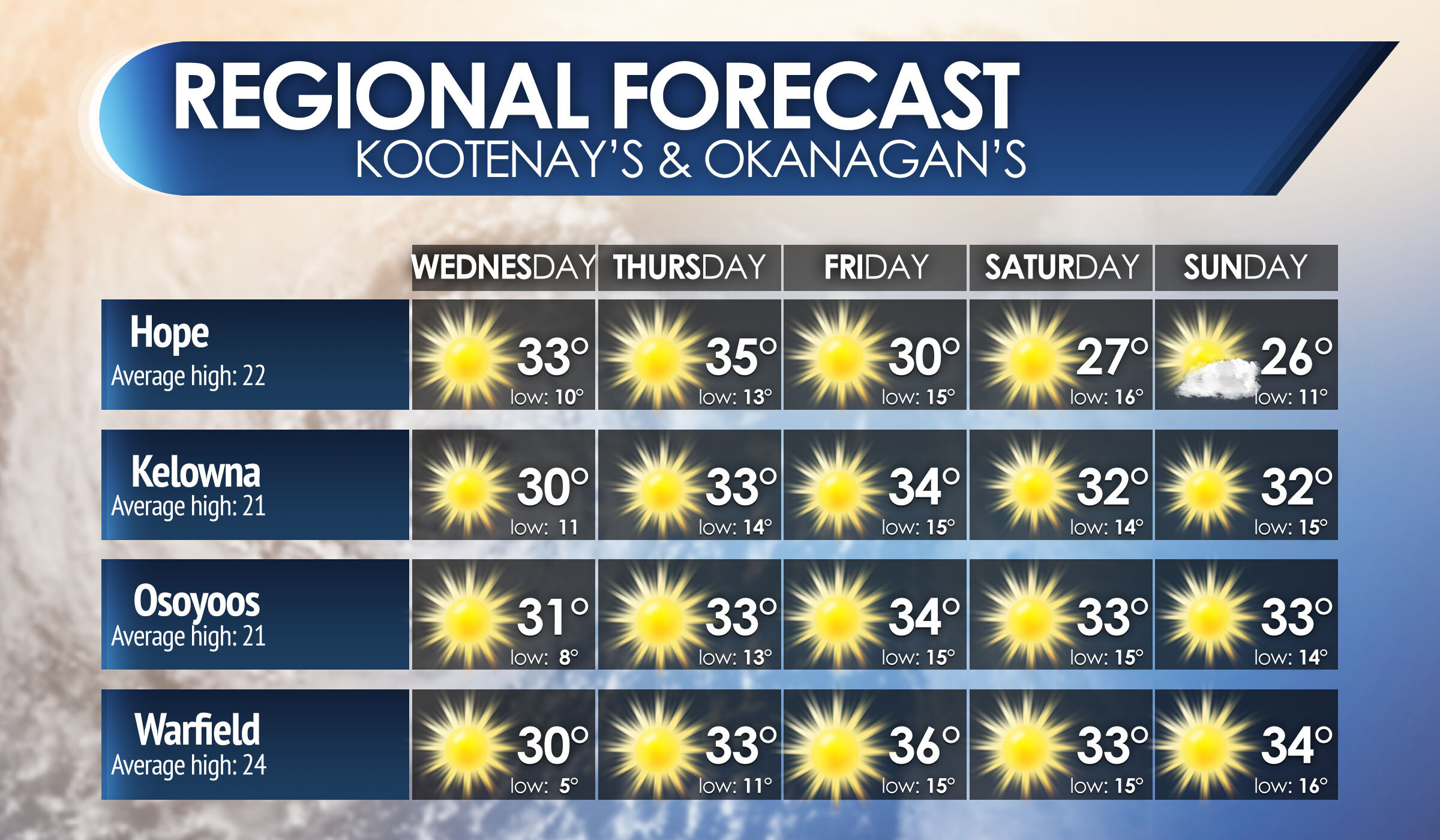
So areas under the ridge tomorrow which will be everyone up and down the entire BC Coast. will see a very lovely Labour Day Monday! and for Northern and Central BC, can expect clouds and much cooler air. parts of the mountains will see temperatures near freezing. for the Southern portions, look for some warmth, about seasonal temperatures, Gusty winds and sunshine!

Now because of the large convergence of the large ridge and large trough, this will bring in some very Gusty winds for much of the province, everyone will see Gusts above 40 km/h, but the strongest winds will be found towards the South, Interior, Okanagan and surrounding areas where Gusts of 70 to as high as 90 km/h is likely.

Trough will be close enough to bring rain to the Rocky Mountains, Columbia Mountains Tonight through tomorrow afternoon. Generally this will be a light rain event, not looking at much rainfall roughly around 5 to 10 mm. there are isolated pockets that can see amounts up to 15 mm on the extreme SE sections of BC, we couldn’t be able to move the legend that is covering that area, but I am forecasting 15 mm in some isolated areas.

Now even though we are going to see a large change in temperatures, and Gusty winds and little rainfall.. that is nowhere near as bad as what the Prairies and much of the Mid-Western states! the Prairies are looking at snow, and cold temperatures near or below freezing.

Think that is bad? How about this, Denver Colorado… still having a heatwave with temperatures nearing 40*C, breaking records they will have one more day of this gorgeous weather, because tomorrow… They can see up to a half foot of snow! Rain, Sleet and strong winds along also with temperatures about 70 degrees colder in a 24 hour period! There are Excessive Heat warning, red flag warnings AND a winter storm warning issued for that state all at the same time! so Be grateful for our small change, compared to a complete flip from blistering heat to a blizzard in a 24 hour period.

Now that change of only a 24 hour period… that will also be the case for us, Tonight into Tuesday, the giant ridge of High pressure off our coast is going to push north and east further inland, this will bring in back that gorgeous sunshine and warmer temperatures for the province, and this will develop a Cut off low for California, they could see some beneficial rain and wind for several days!

and the models are suggesting that the jet stream will be over our province for the next 10 days, well into Mid September with several many more days of 30+ degree heat coming to the south and coast. There are signs that we could see some cooler air and rainfall from a low off the coast after the 10 day period.

Closer to the future though, plan on a change in weather today, followed by another long stretch heatwave for the Interior beginning Wednesday into the weekend.

Severe Thunderstorms Possible Through Southern Ontario Early Monday Morning

Valid: Monday, September 7, 2020

NOTE: The tornado risk zone outlines the region with the highest probability of tornadoes, but tornadoes may occur outside of the zone.


Timing

Southwestern: 12AM - 7AM
Golden Horseshoe: 2AM - 10AM
Central: 1AM - 7AM
Eastern: 5AM - 11AM
Northeastern: 12AM - 5AM

Not sure what region you are in? Click here for a map showing the regions across Southern Ontario. Northeastern Ontario is north of North Bay (not shown on map).

Thunderstorm Threatcast


Thunderstorm Confidence

Very High (90%)


Severe Confidence

Low (25%)


Tornadoes

Isolated


Max Wind Gusts

100+ kmh | 62+ mph


Max Hail Size

Quarter
~2.5cm | ~1"


Max 24-hr Rainfall

~75 mm | ~3"

Forecast Discussion

A developing cluster of storms currently located over Michigan late Sunday evening is expected to track across Lake Huron and into Southwestern Ontario after midnight. These storms have the potential to become severe especially right as they make landfall around the Lake Huron shoreline and extending into Extreme Southwestern Ontario.

Strong wind gusts in excess of 90-100km/h are the main threat with these storms along with small hail and very frequent lightning strikes. Flash flooding could also be a concern with the slow-moving nature of these storms. An isolated tornado cannot be completely ruled out, especially later in the morning and very early afternoon so be sure to have a plan in place should a Tornado Warning be issued for your area.

This line of storms will slowly decay throughout Monday morning as to track towards the east. All severe risk should come to an end shortly after sunrise around 7-9 am with scattered showers and embedded non-severe thunderstorms remaining. There is a questionable severe risk later in the day on Monday for Eastern Ontario - we’ll issue a separate forecast if it’s necessary.

+ Attribution

Icons made by Good Ware from www.flaticon.com

Chilly Air to Invade Saskatchewan for the First Week of September With Temperatures Near the Freezing Mark

Valid: Tuesday, September 8, 2020

Forecast Discussion

It’s hard to believe, but we’re already heading into September and that means we have to say goodbye to the hot scorching temperatures we’ve seen this summer and hello to the colder fall nights. And Mother Nature isn’t wasting any time with temperatures near or slightly below the freezing mark to start off the first full week of September across Saskatchewan.

We’ll begin to see the invasion of this chilly air overnight Sunday and into Monday with overnight lows in the low to mid-single digits. The temperatures will warm up slightly during the day on Monday with daytime highs around 7-12°C. We expect the coldest temperatures will occur overnight Monday and into Tuesday morning where many areas throughout the province will be hovering near the freezing mark or even the low single negative digits.

When it comes to the S-word, the temperature is certainly favourable for a few flurries but there isn’t much moisture expected in the region that will be near the freezing mark Tuesday morning so most areas likely won’t see their first snow just yet.

This cold snap will be brief though because temperatures will warm up substantially as we head into the middle and end of the week. By next weekend, we could be talking about daytime highs in the 20s!

+ Attribution

Icons made by Good Ware from www.flaticon.com
Icons made by Freepik from www.flaticon.com

Chilly Air to Invade Manitoba for the First Week of September With Temperatures Near the Freezing Mark

Valid: Tuesday, September 8, 2020

Forecast Discussion

It’s hard to believe, but we’re already heading into September and that means we have to say goodbye to the hot scorching temperatures we’ve seen this summer and hello to the colder fall nights. And Mother Nature isn’t wasting any time with temperatures near or slightly below the freezing mark to start off the first full week of September across Manitoba.

We’ll begin to see the invasion of this chilly air overnight Sunday and into Monday with overnight lows in the low to mid-single digits. The temperatures will warm up slightly during the day on Monday with daytime highs around 5-10°C. We expect the coldest temperatures will occur overnight Monday and into Tuesday morning where many areas throughout the province, especially in the Western part of Manitoba will be hovering near the freezing mark or even the low single negative digits. Central Manitoba including Winnipeg should stay above the freezing mark around 2-4°C.

When it comes to the S-word, the temperature is certainly favourable for a few flurries but there isn’t much moisture expected in the region that will be near the freezing mark Tuesday morning so most areas likely won’t see their first snow just yet. But certainly further north through the Thompson and Churchill area could see a few centimetres of snow.

This cold snap will be brief though because temperatures will warm up substantially as we head into the middle and end of the week. By next weekend, we could be talking about daytime highs in the high teens or even low 20s!

+ Attribution

Icons made by Good Ware from www.flaticon.com
Icons made by Freepik from www.flaticon.com

Severe Storms Possible Through Eastern Ontario Wednesday Afternoon/Evening With the Potential for an Isolated Tornado

Valid: Wednesday, September 2, 2020

NOTE: The tornado risk zone outlines the region with the highest probability of tornadoes, but tornadoes may occur outside of the zone.


Timing

Southwestern: 2 - 4PM
Golden Horseshoe: 2 - 5PM
Central: 2 - 6PM
Eastern: 3 - 9PM
Northeastern: N/A

Not sure what region you are in? Click here for a map showing the regions across Southern Ontario. Northeastern Ontario is north of North Bay (not shown on map).

Thunderstorm Threat Breakdown


Thunderstorm Confidence

High (75%)


Severe Confidence

Low (25%)


Tornadoes

Isolated


Max Wind Gusts

100+ kmh | 62+ mph


Max Hail Size

Quarter
~2.5cm | ~1"


Max 24-hr Rainfall

~50 mm | ~2"

Forecast Discussion

Heavy showers and non-severe thunderstorms have developed east of Georgian Bay earlier today and are tracking to the east towards Eastern Ontario along the Quebec border. The environment throughout Eastern Ontario is capable for these storms to become severe during the late afternoon into early evening hours. The main threat with these storms will be strong wind gusts potentially in excess of 100km/h and small hail. There is also the threat of an isolated tornado along the Quebec border from Algonquin Park to Ottawa although the risk is much stronger on the Quebec side of the border.

There is a very questionable severe risk through the Niagara region with strong wind gusts up to 90km/h as the main concern, but storm development isn’t guaranteed. The storm risk will come to an end around 9-10 PM as the storms move out of the province.

+ Attribution

Icons made by Good Ware from www.flaticon.com

Rainy Thursday With the Potential for Severe Thunderstorms and Flash Flooding in the Afternoon & Evening Throughout Southwestern Ontario and the Niagara Region

Valid: Thursday, August 27, 2020

NOTE: The tornado risk zone outlines the region with the highest probability of tornadoes, but tornadoes may occur outside of the zone.


Timing

Southwestern: 3PM - 12AM
Golden Horseshoe: 12PM - 8PM
Central: 12AM - 10AM
Eastern: 12AM - 12PM
Northeastern: 12AM - 8AM

Not sure what region you are in? Click here for a map showing the regions across Southern Ontario. Northeastern Ontario is north of North Bay (not shown on map).

Thunderstorm Threatcast


Thunderstorm Confidence

Very High (90%)


Severe Confidence

Low (25%)


Tornadoes

Isolated


Max Wind Gusts

90+ kmh | 56+ mph


Max Hail Size

Quarter
~2.5cm | ~1"


Max 24-hr Rainfall

~100 mm | ~4"

Forecast Discussion

Thunderstorm activity will continue to linger throughout the overnight hours and into Thursday morning as another wave of storms sweeps through Central and Eastern Ontario during the early morning. These storms should remain non-severe although flooding could be a concern particularly in the heavier thunderstorm activity where upwards of 50mm is possible east of Georgian Bay. This nocturnal activity will come to an end by noon as they move across the border and into Upstate New York.

Another round of storms is possible later in the afternoon and into the evening where some of them could reach severe limits, especially with the flooding threat. This threat will be focused on Extreme Southwestern Ontario and along the Lake Erie shoreline although it could make its way into the Western GTA and Niagara region. As mentioned, the flooding threat is the main concern because storms could ‘train’ over a specific location for several hours leading to locally over 100mm of rainfall accumulation. Moderate size hail and strong wind gusts are also possible. The tornado threat isn’t particularly strong but an isolated one can’t be ruled out around the Sarnia, Chatham-Kent and London corridor. The storm threat will end near the midnight hour.

+ Attribution

Icons made by Good Ware from www.flaticon.com